ATLAS of ANTIENT GEOGRAPHY by SAMUEL BUTLER 1843John McInnis Auctioneers,LLC4.6(504)See Sold PriceFeb 24, 2024
18TH C. ANTIQUE MAP: FRENCH & INDIAN WAR, FRAMEDThomaston Place Auction Galleries4.4(389)See Sold PriceFeb 24, 2024
Rand McNally Railroad Map Cabinet w/ 21 Railroad MapsRail & Road Auctions4.6(165)See Sold PriceMar 08, 2024
Keith Haring - Ink on New York Map, Best Buddies, Inscribed, Signed, and DatedSapphire Auction Gallery4.1(67)See Sold PriceMar 02, 2024
LATE 17TH C. FRENCH MAP OF THE NEW WORLD BY ALEXIS-HUBERT JAILLOT (1632-1712)Thomaston Place Auction Galleries4.4(389)See Sold PriceFeb 24, 2024
Central Railroad of New Jersey Map of Sandy Hook Route-ca. 1903JM Hobby Supply and Railroad Artifact Auctions4.4(126)See Sold PriceFeb 24, 2024
Lot of Six Mixed Atlas Box Cars-HO Scale-New in BoxJM Hobby Supply and Railroad Artifact Auctions4.4(126)See Sold PriceFeb 25, 2024
Rand McNally/Santa Fe Railroad Map of Iowa-1912JM Hobby Supply and Railroad Artifact Auctions4.4(126)See Sold PriceFeb 24, 2024
NICOLAES VISSCHER (NETHERLANDS, 1618-1709) MAP OF THE NEW WORLDThomaston Place Auction Galleries4.4(389)See Sold PriceFeb 24, 2024
17TH C. WORLD MAP BY NICOLAES VISSCHER (NETHERLANDS, 1618-1709)Thomaston Place Auction Galleries4.4(389)See Sold PriceFeb 24, 2024
Lot of Six Mixed Atlas Cabooses-HO Scale-New in BoxJM Hobby Supply and Railroad Artifact Auctions4.4(126)See Sold PriceFeb 25, 2024
SoldBowen. An Improved Map of Wilt Shire. c.1760.[England] Bowen, Emanuel. “An Improved Map of Wilt Shire Divided into its Hundreds.” London, John Bowles, c.1760. Engraved map. 17” x 21”. Mounted. Hand-colored. Cartouche andSee Sold Price
SoldA mixed group of English county mapsA mixed group of English county maps,including 3 maps by Morden, 2 of Wiltshire, 1 of Hampshire, an Ogilby road map from 'Monmouth to Llanbeder, c.1676, a Bowen map of Middlesex, and 6 othersSee Sold Price
WiltshireTitle/Content of Map: Wiltshire Date: 1759 Cartographer: BOWEN, EMANUEL Size: 6.8X7.75 "divided into its hundreds, containing the city, burough & market towns, with the roads and distances. By Eman. BSee Sold Price
WiltshirePublication Date: 1759 Title: Wiltshire Cartographer: BOWEN, EMANUEL Height: 6.8 Width: 7.75 "divided into its hundreds, containing the city, burough & market towns, with the roads and distances. By ESee Sold Price
SoldMoule, Thomas C1838 British Map. Wiltshire StonehengeSteel Engraved Map Published C1838 for "A Complete and Universal English Dictionary" by the Rev. James Barclay et al. Maps by Thomas Moule. Paper Size: 10.5 x 8 inch (27 x 21cm) Good ConditionSee Sold Price
SoldMoule, Thomas C1850 British Map. Wiltshire StonehengeSteel Engraved Map Published C1850 "A Complete and Universal English Dictionary" by the Rev. James Barclay et al. Maps by Thomas Moule. Paper Size: 10.5 x 8 inch (27 x 21cm) Good ConditionSee Sold Price
SoldRobert Morden Map of Wilt Shire 13.5 x 16in.Robert Morden coloured engraving Map of Wilt Shire 13.5 x 16in.See Sold Price
Sold19th century hand coloured map of Wiltshire reading19th century hand coloured map of Wiltshire reading 'Map of the County of Wilts. from an accurate survey made in the years 1819 and 1820 by C. and I. Greenwood, published by the proprietors, GreenwoodSee Sold Price
Sold18TH AND 19TH CENTURY MAPS18th C. map of Wilt Shire measures 7 inches x 4.5 inches sight size through the mat. The 19th century map of Rome measures 8 inches x 11.75 inches sight size through the matSee Sold Price
SoldAntique Map of Wilshire by John SpeedEngraved by Jodocus Hondius from The Theatre of the Empire of Great Britaine (1611). A Renaissance map of Wiltshire, UK, with a town map of Salisbury and a view of Stonehenge and a number of coats ofSee Sold Price
Blaue Map. Wiltonia Sive Comitatus Wiltoniensis.This map of Wiltshire was published in "Guil. et Ioannis Blaeu Theatrum Orbis Terrarum, sive Atlas Novus - Part IV". Beautifully Hand Colored. Approx. 16 1/4 x 20".See Sold Price
SoldHendrik Frans de Cort (Dutch, 1742-1810) - The greatHendrik Frans de Cort (Dutch, 1742-1810) The great Elm in Lord Suffolk's ground, Wiltshire, a boundary tree known in the 'Old Maps of Wiltshire' inscribed with title to the reverse pencil 62 x 46cm (2See Sold Price
Staffordshire.- Bowen (Emanuel) - An Improved Map oflarge vignette title with rustic figures washing at a conduit head, upper left, dedication cartouche upper right and descriptive text all around, engraved map with original hand-colouring in outline,See Sold Price
Bowen: Antique Map of Oxford Shire, 1758Title/Content of Map: Oxford Shire Date Printed: 1758 Cartographer: BOWEN, EMANUEL Size (inches): 7x7.8 "divided into its hundreds containing the cities, burough and market towns, with the roads & disSee Sold Price
Bowen: Antique Map of Somerset Shire, 1759Title/Content of Map: Somerset Shire Date Printed: 1759 Cartographer: BOWEN, EMANUEL Size (inches): 6.25x8.25 "divided into its hundreds containing the cities, burough and market towns, with the roadsSee Sold Price
Bowen (Emanuel) Map of Cambridge ShireBowen (Emanuel) An Accurate Map of Cambridge Shire, Divided into Hundreds,large decorative title vignette of waterfowling and eel fishing, lower left, with an elevation of Ely Cathedral upperSee Sold Price
Sold[ENGLAND]. Emanuel Bowen. An Accurate Map Of[ENGLAND]. Emanuel Bowen. An Accurate Map Of Northampton Shire. Divided into its Hundreds... Printed for Robert Wilkinson & Robert Sayer, c.1753-85. 27 1/2 x 21. Double-page engraved map, outline coloSee Sold Price
SoldBowen (Emanuel) - An Accurate map of Devon Shirelarge title vignette of local coastal trades, upper right, inset plan of Plymouth lower right, engraved map with hand-colouring, 685 x 530mm., central vertical fold, faint browning and light spotting,See Sold Price
SoldAfter Emanuel Bowen (1693-1767) British. "NorthamptonAfter Emanuel Bowen (1693-1767) British. "Northampton Shire", Map, Unframed, 7.5" x 7", together with Nine similar Maps, "Oxford Shire", "Lancashire", "Lincolnshire", "Nottingham Shire", "Stratford ShSee Sold Price
SoldEmanuel Bowen (1693-1767) British. "A Map of RadnorEmanuel Bowen (1693-1767) British. "A Map of Radnor Shire", Map, Unframed, 7.25" x 5", and Five other various Maps by different hands, Six (6).See Sold Price
England.- Bowen (Emanuel) An Accurate Map of SussexEngland.- Bowen (Emanuel) An Accurate Map of Sussex ...' Northhampton Shire ...; Nottingham Shire ..., three county maps, engravings, each 570 x 750 mm. (22 1/2 x 29 1/ 2 in ), or the reverse, marginaSee Sold Price
Kitchin (Thomas) Improved Map of HampshireKitchin (Thomas) A New Improved Map of Hampshire,engraved map partly hand-coloured in outline, dissected and linen-backed, 504 x 710 mm., n.d. [c.1760].See Sold Price
SoldJOANNES JANSSON WILTSHIREJoannes Jansson Wiltonia sive Comitatus Wiltoniensis. Anglis Wil Shire, hand coloured map, with good margins, a good impression 41 x 50cmSee Sold Price
OGILVY & BOWEN c1736 Original Map of Oxfordshire Berkshire Etc.Luis Porretta Fine Arts4.3(10)See Sold PriceMar 02, 2024
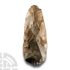
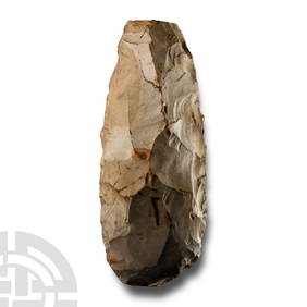
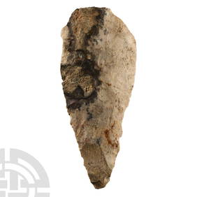
Stone Age 'Salisbury' Grey with Cortex Knapped Flint AxeTimeLine Auctions Ltd.4.6(182)See Sold PriceMar 05, 2024
[ARCTIC]. BOWEN, Emanuel. A New & Accurate Map of the North...Potter & Potter Auctions4.6(544)See Sold PriceMar 07, 2024
Map: An engraved and hand coloured map titled The Countie of Nottingham described The Shire TownesClaydon Auctioneers Ltd4.3(125)See Sold PriceFeb 26, 2024
Map: An 18thC engraved map of Bedfordshire titled An Accurate Map of the County of Bedford DividedClaydon Auctioneers Ltd4.3(125)See Sold PriceFeb 26, 2024
Map: An 18thC engraved map titled A New and Improved Map of Oxfordshire.. after Thomas Kitchin.Claydon Auctioneers Ltd4.3(125)See Sold PriceFeb 26, 2024
1750 Bowen Map of Bermuda and St. Kitts -- A New & Accurate Map of Bermudas or Sommer's Islands...Jasper524.5(9.8k)See Sold PriceFeb 27, 2024
New and Correct Map of North America With the West India Islands,Jasper524.5(9.8k)See Sold PriceFeb 27, 2024
COLONIAL CENTRAL AFRICA. Congo German East Africa Rhodesia. BARTHOLOMEW 1898 mapJasper524.5(9.8k)See Sold PriceFeb 28, 2024


![[ENGLAND]. Emanuel Bowen. An Accurate Map Of (1 of 1)](https://p1.liveauctioneers.com/179/10971/2682715_1_x.jpg?height=282&quality=70&version=1162265652)


![[ARCTIC]. BOWEN, Emanuel. A New & Accurate Map of the North... (1 of 1)](https://p1.liveauctioneers.com/928/318880/171360917_1_x.jpg?height=282&quality=70&version=1707501302)


