ATLAS of ANTIENT GEOGRAPHY by SAMUEL BUTLER 1843John McInnis Auctioneers,LLC4.6(504)See Sold PriceFeb 24, 2024
18TH C. ANTIQUE MAP: FRENCH & INDIAN WAR, FRAMEDThomaston Place Auction Galleries4.4(389)See Sold PriceFeb 24, 2024
Rand McNally Railroad Map Cabinet w/ 21 Railroad MapsRail & Road Auctions4.6(165)See Sold PriceMar 08, 2024
Keith Haring - Ink on New York Map, Best Buddies, Inscribed, Signed, and DatedSapphire Auction Gallery4.1(67)See Sold PriceMar 02, 2024
LATE 17TH C. FRENCH MAP OF THE NEW WORLD BY ALEXIS-HUBERT JAILLOT (1632-1712)Thomaston Place Auction Galleries4.4(389)See Sold PriceFeb 24, 2024
Central Railroad of New Jersey Map of Sandy Hook Route-ca. 1903JM Hobby Supply and Railroad Artifact Auctions4.4(126)See Sold PriceFeb 24, 2024
Lot of Six Mixed Atlas Box Cars-HO Scale-New in BoxJM Hobby Supply and Railroad Artifact Auctions4.4(126)See Sold PriceFeb 25, 2024
Rand McNally/Santa Fe Railroad Map of Iowa-1912JM Hobby Supply and Railroad Artifact Auctions4.4(126)See Sold PriceFeb 24, 2024
NICOLAES VISSCHER (NETHERLANDS, 1618-1709) MAP OF THE NEW WORLDThomaston Place Auction Galleries4.4(389)See Sold PriceFeb 24, 2024
17TH C. WORLD MAP BY NICOLAES VISSCHER (NETHERLANDS, 1618-1709)Thomaston Place Auction Galleries4.4(389)See Sold PriceFeb 24, 2024
Lot of Six Mixed Atlas Cabooses-HO Scale-New in BoxJM Hobby Supply and Railroad Artifact Auctions4.4(126)See Sold PriceFeb 25, 2024
Sold3 maps of the Baltimore/Washington area.[America/ Virginia & Maryland] Various. 3 maps. (1) Hopkins, Griffith Morgan. “Map of Baltimore and Environs.” 1877. Engraved map. 24 1/8” x 16 1/4”. (2) Johnson & Browning. âSee Sold Price
SoldDelamarche: Antique Map of the Americas, 1818Title/Content of Map: Carte Generale De L'amerique Divisee En Ses Principaux Etats Date Printed: 1818 Cartographer: DELAMARCHE, FELIX apres Robert de Vaugondy Size: 21X23.3 Period map with areas of noSee Sold Price
SoldAmerica 1690 UNKNOWN 20thC Print Hand Colored LaidDetails: UNKNOWN. America 1690. 20th century. Hand-colored print on laid, watermarked paper. 21 1/8 x 25 3/4". Map shows areas of Native American habitation, settlements, political divisions, vegetatSee Sold Price
3 REICH GERMA MAP 1940 AREA OF BELARUS 1940MAP 1940 TSCHERWENJ Sonderausgaben X. 1940 Special editions X. 1940 Nur für den Dienstgebrauch! For official use only! Tscherenj :The Tscherwenj District (formerly Belarus: Чэ́рSee Sold Price
3 REICH LUFTWAFFE MAP KIEV AREA UKRAINE 1941DEUTSCHE WELTKARTE 1:500 000 KIJEW-SSUMY Sonderausgaben Einzelne Nachträge 1941 (Special editions, individual supplements 1941) Nur für den Dienstgebrauch! For official use only! Luftwaffe map KievSee Sold Price
SoldMunster (Sebastian) Tabula Asiae VII(-IX)Munster (Sebastian) Tabula Asiae VII(-IX), 3 woodcut maps of the area between modern Iran and northern India, average 250 x 320mm., sheets 300 x 380mm., centre folds, old red-brown rules outsiSee Sold Price
Des Furstenthums Asturien Westlicher Theil Nro. 588.Title: Des Furstenthums Asturien Westlicher Theil Nro. 588. Publication Date: 1797 ca. Cartographer: LOPEZ, T. i.e. L. de V.M. ? Size: 9.5X11.3 Detailed area map from a German edition of Lopez's miniaSee Sold Price
Die Provinz La Mancha Nro.562.Title: Die Provinz La Mancha Nro.562. Cartographer: LOPEZ, T. i.e. L. de V.M. ? Height: 7.75 Width: 10.3 Detailed area map from a German edition of Lopez's miniature atlas of Spain done for participanSee Sold Price
Die Provinz La Mancha Nro.562.Publication Date: c1797 Title: Die Provinz La Mancha Nro.562. Cartographer: LOPEZ, T. i.e. L. de V.M. ? Height: 7.75 Width: 10.3 Detailed area map from a German edition of Lopez's miniature atlas of SSee Sold Price
Denver, Colorado Artesian BasinTitle: Denver, Colorado Artesian Basin Publication Date: 1890 Cartographer: U.S.G.S. Publisher: U.S.G.S. Size: 17 X 14.3 Grid map of Denver & adjoining areas (Boulder, Fort Lupton, Golden, etc.). ShowSee Sold Price
SoldCOLTON, George Woolworth (1827-1901). Map of theCOLTON, George Woolworth (1827-1901). Map of the Country Thirty Three Miles Around the City of New York. New York: J. H. Colton, 1846 [i.e., 1865]. Hand-colored lithographed map, visible area 23 3/4 bSee Sold Price
SoldOld West Surrey, plates and illustrations, originalOld West Surrey, plates and illustrations, original cloth, gilt, slightly marked, spine dulled, 1904; and 8 others, Topography, including 3 Ordnance Survey maps of the Witley area, tears along folds,See Sold Price
Sold3 Reich - German map of the Litzmannstadt Ghetto AreaVery worn condition German map of the Litzmannstadt Ghetto area in Lodz, when occupied by Germany. Map is so used and worn that it was repaired and reinforced in all the edges with adhesive type. HoweSee Sold Price
Sold3 Reich - German map of the Litzmannstadt Ghetto AreaWorn condition German map of the Litzmannstadt Ghetto area in Lodz, when occupied by Germany. Map is so used and worn that it was repaired and reinforced in all the edges with adhesive type. However iSee Sold Price
Mitchell, S.A. Canada E. & W., N.S. & N.B. (3 maps)Mitchel, Samuel A. Canada East, Canada West, Nova Scotia and New Brunswick (3 maps) 1860 Steel engraving; outline coloured Printed area: Brunswick: 10.6 x 13.3 cm; 4.1 x 5.2 in; Map of Canada East inSee Sold Price
Seutter, M. Electoratus sive Marchia BrandenburgensisSeutter, Matthaus Electoratus sive Marchia Brandenburgensis C. 1725 Copperplate engraving; area coloured Printed area: 55.6 x 49.2 cm; 21.8 x 19.3 in The map shows the the elective area of the Mark BrSee Sold Price
SoldMontana Tourist MemorabiliaThis lot is Montana Tourist Memorabilia. There are 40 Public Lands in Montana maps of different areas, 3 Charles M. Russell National Wilderness Refuge maps, 1 Northern Pacific Yellowstone Park Line brSee Sold Price
New York Central RR The Adirondacks Brochure 1916-1917JM Hobby Supply and Railroad Artifact Auctions4.4(126)See Sold PriceFeb 24, 2024
DUNLEVIE c1856 Map Counties Of Gaspe & Bonaventure Quebec Canada SCARCE! #1Luis Porretta Fine Arts4.3(10)See Sold PriceMar 02, 2024
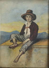
Alfoner Watercolor on paper, portrait "Hirtenknabe" or Shepherd boy, c 1843Global Auctions Company4.3(36)See Sold PriceMar 03, 2024
17th Century Hand Colored Engraved Map of GermanyGlobal Auctions Company4.3(36)See Sold PriceMar 03, 2024
Theodore Rousseau (1812-1867) Oil on Panel Pastoral LandscapeHughes Auctions4.4(165)See Sold PriceFeb 25, 2024
Map of St. Kitts and Nevis Depot de la Marine, Paris, 1758Global Auctions Company4.3(36)See Sold PriceMar 03, 2024
Hand Colored Engraved Map of Europe, Jean Baptiste Bourguignon Anville 1754Global Auctions Company4.3(36)See Sold PriceMar 03, 2024
Chatelain - 3 Maps of the British Isles (England, Ireland, Scotland)Trillium Antique Prints & Rare Books4.5(30)See Sold PriceFeb 24, 2024
MODERN BATHROOM BEDROOM DINING ROOM CRYSTAL WALL SCONCE FIXTURE BLACK LIGHT 18inBidhaus4.3(757)See Sold PriceMar 04, 2024
Hand Knotted Tribal Navy Amber Nomadic Afghan Balouch Oriental Wool Area Rug 3' x 5'4"Jasper524.5(9.8k)See Sold PriceFeb 28, 2024
Emory's Notes of a Military Reconnoissance larger issuePBA Galleries4.7(383)See Sold PriceMar 07, 2024
Operation Torch Nov 1942-May 1943. World War 2. Western Mediterranean 1966 mapJasper524.5(9.8k)See Sold PriceFeb 28, 2024
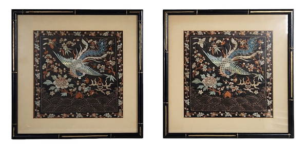
Two Framed Chinese Silk Art TapestriesLegacy Auctions & Estate Sales4.6(72)See Sold PriceFeb 29, 2024
Set of 3 Maps - Netherlands - Belgien - Switzerland - J. BarlowProverde Auctions4.3(3)See Sold PriceFeb 28, 2024
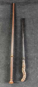
Harry Potter Interactive Oak & Hazel Wands Universal StudiosRapid Estate Liquidators and Auction Gallery4.5(1.1k)See Sold PriceFeb 27, 2024
Interactive Luna & Ginny Potter Wands Universal StudiosRapid Estate Liquidators and Auction Gallery4.5(1.1k)See Sold PriceFeb 27, 2024