ATLAS of ANTIENT GEOGRAPHY by SAMUEL BUTLER 1843John McInnis Auctioneers,LLC4.6(502)See Sold PriceFeb 24, 2024
18TH C. ANTIQUE MAP: FRENCH & INDIAN WAR, FRAMEDThomaston Place Auction Galleries4.4(386)See Sold PriceFeb 24, 2024
Rand McNally Railroad Map Cabinet w/ 21 Railroad MapsRail & Road Auctions4.6(165)See Sold PriceMar 08, 2024
Keith Haring - Ink on New York Map, Best Buddies, Inscribed, Signed, and DatedSapphire Auction Gallery4(67)See Sold PriceMar 02, 2024
LATE 17TH C. FRENCH MAP OF THE NEW WORLD BY ALEXIS-HUBERT JAILLOT (1632-1712)Thomaston Place Auction Galleries4.4(386)See Sold PriceFeb 24, 2024
Central Railroad of New Jersey Map of Sandy Hook Route-ca. 1903JM Hobby Supply and Railroad Artifact Auctions4.4(126)See Sold PriceFeb 24, 2024
Lot of Six Mixed Atlas Box Cars-HO Scale-New in BoxJM Hobby Supply and Railroad Artifact Auctions4.4(126)See Sold PriceFeb 25, 2024
Rand McNally/Santa Fe Railroad Map of Iowa-1912JM Hobby Supply and Railroad Artifact Auctions4.4(126)See Sold PriceFeb 24, 2024
NICOLAES VISSCHER (NETHERLANDS, 1618-1709) MAP OF THE NEW WORLDThomaston Place Auction Galleries4.4(386)See Sold PriceFeb 24, 2024
17TH C. WORLD MAP BY NICOLAES VISSCHER (NETHERLANDS, 1618-1709)Thomaston Place Auction Galleries4.4(386)See Sold PriceFeb 24, 2024
Lot of Six Mixed Atlas Cabooses-HO Scale-New in BoxJM Hobby Supply and Railroad Artifact Auctions4.4(126)See Sold PriceFeb 25, 2024
SoldAN ANTIQUE MAP, "Spanish North America," 1814,AN ANTIQUE MAP, "Spanish North America," 1814, hand colored engraving on paper, "Drawn and Engraved for Thomson's New General Atlas..." 20" x 25" Note: "A large map of Texas, Mexico and the American SSee Sold Price
SoldJohn Thomson, Spanish North America, double pageJohn Thomson, Spanish North America, double page engraved map of Texas and Mexico, sight size 20 3/4" x 25". Provenance: Property from the Credit Suisse Americana Collection.See Sold Price
Thomson: Antique Map of Spanish North America, 1817Title/Content of Map: 'Spanish North America [northern part]' A large map of Texas, Mexico and the American Southwest, published in Edinburgh by John Thompson, based on the explorations of Humboldt anSee Sold Price
Thomson: Antique Map of Spanish North America, 1817Title/Content of Map: 'Spanish North America [northern part]' A large map of Texas, Mexico and the American Southwest, published in Edinburgh by John Thompson, based on the explorations of Humboldt anSee Sold Price
SoldUnframed Map Engraving Spanish North AmericaUnframed Map Engraving Spanish North America - Southern Part - drawn & engraved for Thomson's New General Atlas - 1816 - 21 1/4" x 28 1/2"See Sold Price
Spanish North America. THOMSON. Texas, Mexico & Southwestern USA 1830 mapTitle: "Spanish North America". THOMSON. Texas, Mexico & Southwestern USA 1830 map Description: Spanish North America [northern part] by Drawn & engraved for John Thomson's "New General Atlas" (1830).See Sold Price
SoldSpanish North America. THOMSON. Texas, Mexico &TITLE/CONTENT OF MAP: 'Spanish North America [northern part]' A large map of Texas, Mexico and the American Southwest, published in Edinburgh by John Thompson, based on the explorations of Humboldt anSee Sold Price
Thomson: Map of Spanish North America, 1817Map Title: 'Spanish North America, southern part' Date Printed: 1817 Size: Approx 53.5 x 66.0cm, 21 x 26 inches (Large) Type: Antique early 19th century atlas map with original hand colouring ConditioSee Sold Price
SoldTwo maps to include: (1) Spanish North America sightTwo maps to include: (1) Spanish North America sight size: 20" x 24 1/2" (2) United States North America According to Calvin, Smith, & Tanner by G.H. Swanston sight size: 21 1/4" x 16 3/4" both pSee Sold Price
Thomson: Antique Map of Spanish North America, 1817TITLE/CONTENT OF MAP: 'Spanish North America, southern part' Central America DATE PRINTED: 1817 IMAGE SIZE: Approx 53.5 x 66.0cm, 21 x 26 inches (Large); Please note that this is a folding map. TYPE:See Sold Price
"Spanish North America, southern part" by John Thomson.TITLE/CONTENT OF MAP: 'Spanish North America, southern part' DATE: 1817 IMAGE SIZE: Approx 53.5 x 66.0cm, 21 x 26 inches (Large); Please note that this is a folding map. TYPE: Antique early 19th centuSee Sold Price
Thomson: Antique Map of Spanish North America, 1817TITLE/CONTENT OF MAP: 'Spanish North America [northern part]' A large map of Texas, Mexico and the American Southwest, published in Edinburgh by John Thompson, based on the explorations of Humboldt anSee Sold Price
"Spanish North America". THOMSON. Texas, Mexico &TITLE/CONTENT OF MAP: Spanish North America [northern part] A large map of Texas, Mexico and the American Southwest. There are extensive observations of Native American Indian settlements and huntingSee Sold Price
Spanish North America.Publication Date: 1817 Title: Spanish North America. Cartographer: THOMSON, JOHN & CO. Publisher: JOHN THOMSON, JUNR. & CO. Height: 20 Width: 24.25 No.45 from Thomson's New General Atlas 1817. Polar pSee Sold Price
SoldA MAP, SPANISH NORTH AMERICA, JOHN THOMSON (& CO.), 184A MAP, SPANISH NORTH AMERICA, JOHN THOMSON (& CO.), 1844. 21" x 28". Framed. The Spanish possessions in North America are the focus of this large and significant map. Especially noteworthy is the deliSee Sold Price
Spanish North America.Title/Content of Map: Spanish North America. Cartographer: THOMSON, JOHN & CO. Date: 1817 Publisher: JOHN THOMSON, JUNR. & CO. Size: 20Height - 24.25Width No.45 from Thomson's New General Atlas 1817.See Sold Price
"Spanish North America". THOMSON. Texas, Mexico &TITLE/CONTENT OF MAP: 'Spanish North America [northern part]' A large map of Texas, Mexico and the American Southwest, published in Edinburgh by John Thompson, based on the explorations of Humboldt anSee Sold Price
Spanish North America.Title/Content of Map: Spanish North America. Date: 1817 Cartographer: THOMSON, JOHN & CO. Publisher: JOHN THOMSON, JUNR. & CO. Size: 20Height - 24.25Width No.45 from Thomson's New General Atlas 1817.See Sold Price
"Spanish North America". THOMSON. Texas, Mexico &TITLE/CONTENT OF MAP: 'Spanish North America [northern part]' A large map of Texas, Mexico and the American Southwest, published in Edinburgh by John Thompson, based on the explorations of Humboldt anSee Sold Price
SoldThomson: Spanish North America / Central AmericaCartographer: John Thomson Place/Date: Edinburgh / 1816 Size: 24 1/4" x 20" Condition: outline color; overall age toning; some overprinting and browning and staining in margins In Thomson's large-scalSee Sold Price
d'Anville: Antique Map of British/French North AmericaAmérique Septentrionale. British French Spanish North America. This fabulous map shows North America divided between British (red), French (Green) and Spanish (Yellow) possessions. At this time the BSee Sold Price
SoldThomson: Antique Map of Central America, 1816Map: Spanish North America Southern Part Cartographer: John Thomson Place & Date: Edinburgh / 1816 Size: 24 1/4" x 20" Condition: outline color; light overprinting; browning and staining in margins InSee Sold Price
Thomson: Antique Map of Central America, 1817Title/Content of Map: 'Spanish North America, southern part' Date Printed: 1817 Image Size: Approx 53.5 x 66.0cm, 21 x 26 inches (Large); Please note that this is a folding map. Type: Antique early 19See Sold Price
Thomson: Antique Map of Central America, 1817TITLE/CONTENT OF MAP: 'Spanish North America, southern part' DATE PRINTED: 1817 IMAGE SIZE: Approx 53.5 x 66.0cm, 21 x 26 inches (Large); Please note that this is a folding map. TYPE: Antique early 19See Sold Price
LARGE EARLY 18TH C. DUTCH CHART OF UPPER NORTH AMERICA, PIERRE MORTIER (1661-1711), FRAMEDThomaston Place Auction Galleries4.4(386)See Sold PriceFeb 24, 2024
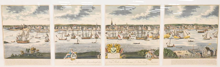
A South Prospect of Ye Flourishing City of New York in the Province of New York, North AmericaNadeau's Auction Gallery4.7(401)See Sold PriceFeb 24, 2024
Audubon's Animals - The Quadrupeds of North America 1954 Folio Size BookNorth American Artifact Auctions4.6(182)See Sold PriceApr 20, 2024
Arrowsmith & Lewis - Map of PolynesiaTrillium Antique Prints & Rare Books4.5(30)See Sold PriceFeb 24, 2024
Arrowsmith & Lewis - Map of North AmericaTrillium Antique Prints & Rare Books4.5(30)See Sold PriceFeb 24, 2024
Arrowsmith & Lewis - Map of the World on Mercator's ProjectionTrillium Antique Prints & Rare Books4.5(30)See Sold PriceFeb 24, 2024
Arrowsmith & Lewis - Map of LouisianaTrillium Antique Prints & Rare Books4.5(30)See Sold PriceFeb 24, 2024
Arrowsmith & Lewis - Map of the United StatesTrillium Antique Prints & Rare Books4.5(30)See Sold PriceFeb 24, 2024
Map: An 18thC engraved and hand coloured map of North America and South America, titled DeClaydon Auctioneers Ltd4.3(125)See Sold PriceFeb 26, 2024
1862 North America Anthony Trollope West Indies AND Spanish Main CANADA NIAGARAJasper524.5(9.8k)See Sold PriceFeb 27, 2024
New and Correct Map of North America With the West India Islands,Jasper524.5(9.8k)See Sold PriceFeb 27, 2024
Map of United States of North America, 1785Antiques Online Auctions4.6(407)See Sold PriceMar 14, 2024