ATLAS of ANTIENT GEOGRAPHY by SAMUEL BUTLER 1843John McInnis Auctioneers,LLC4.6(502)See Sold PriceFeb 24, 2024
18TH C. ANTIQUE MAP: FRENCH & INDIAN WAR, FRAMEDThomaston Place Auction Galleries4.4(386)See Sold PriceFeb 24, 2024
Rand McNally Railroad Map Cabinet w/ 21 Railroad MapsRail & Road Auctions4.6(165)See Sold PriceMar 08, 2024
Keith Haring - Ink on New York Map, Best Buddies, Inscribed, Signed, and DatedSapphire Auction Gallery4(67)See Sold PriceMar 02, 2024
LATE 17TH C. FRENCH MAP OF THE NEW WORLD BY ALEXIS-HUBERT JAILLOT (1632-1712)Thomaston Place Auction Galleries4.4(386)See Sold PriceFeb 24, 2024
Central Railroad of New Jersey Map of Sandy Hook Route-ca. 1903JM Hobby Supply and Railroad Artifact Auctions4.4(126)See Sold PriceFeb 24, 2024
Lot of Six Mixed Atlas Box Cars-HO Scale-New in BoxJM Hobby Supply and Railroad Artifact Auctions4.4(126)See Sold PriceFeb 25, 2024
Rand McNally/Santa Fe Railroad Map of Iowa-1912JM Hobby Supply and Railroad Artifact Auctions4.4(126)See Sold PriceFeb 24, 2024
NICOLAES VISSCHER (NETHERLANDS, 1618-1709) MAP OF THE NEW WORLDThomaston Place Auction Galleries4.4(386)See Sold PriceFeb 24, 2024
17TH C. WORLD MAP BY NICOLAES VISSCHER (NETHERLANDS, 1618-1709)Thomaston Place Auction Galleries4.4(386)See Sold PriceFeb 24, 2024
Lot of Six Mixed Atlas Cabooses-HO Scale-New in BoxJM Hobby Supply and Railroad Artifact Auctions4.4(126)See Sold PriceFeb 25, 2024
Scarce 1849 map of China, Joseph MeyerEngraved outline hand color map of China by Joseph Meyer. From Meyer’s scarce 1850 Zeitlung atlas. Scarce and interesting with lots of detail. Very light toning. 8.375 x 10.25 Reserve: $40.00 ShippiSee Sold Price
SoldScarce 1849 map of AmericaScarce 1849 map of North America and South America by Joseph Meyer as found in the Meyer’s Zeitungs-Atlas of 1850. Shows all of North America as well as South America from the Arctic to Cape Horn. ISee Sold Price
Scarce 1849 map of AmericaScarce 1849 map of North America and South America by Joseph Meyer as found in the Meyer’s Zeitungs-Atlas of 1850. Shows all of North America as well as South America from the Arctic to Cape Horn. ISee Sold Price
SoldScarce 1850 world hemispheres mapInteresting and scarce map by Joseph Meyer highlighting how much of the Earth is land and how much is water. Various tables of information also adorn the map. Original outline hand color. From Meyer��See Sold Price
1849 Joseph Meyer map of IrelandThis antique map of Ireland shows each county in the country. Really nice topographical rendering. Original outline hand coloring. From an 1850 edition of Meyer’s Zeitungs Atlas. Some soiling anSee Sold Price
1849 Joseph Meyer map of ScotlandHighly detailed map of Scotland from Joseph Meyer’s Zeitungs Atlas. Dated 1849, this map shows forts, rivers, mountain passes, rapids, fords, cities, towns, rivers, coastal features and highly rSee Sold Price
SoldScarce 1850 plants distributionScarce 1850 map or chart by Joseph Meyer depicting plant geography. Shows the distribution of vegetation throughout the world. Features five illustrations showing the vegetation in various regions, inSee Sold Price
SoldIsothermal Curves of N. Hemisphere, 1850Scarce map showing northern regions of the globe, along with the isothermal curves in that hemisphere. By Joseph Meyer from Meyer’s Zeitungs-Atlas of 1850. General toning with some scattered foxing.See Sold Price
Scarce 1850 map of New EnglandEngraved outline hand color map of New England by Joseph Meyer. From Meyer’s 1850 Zeitlung atlas. Insets of Boston, New Haven and Hartford. Shows administrative boundaries, cities and towns. ReliefSee Sold Price
Sold6pc 19th Century German Maps of China6pc 19th Century German Maps of China. Includes Weimar 'Charte vom China' 1820 (15.25x18.5''), Joseph Meyer 'Chinesische Reich' 1846 (14.75x18''), 3pc Kaegelmann 'maps of China, Mongolia, and Tibet' (See Sold Price
Map of Duchy of Brunswick in Germany, Meyer 1849Map titled Herzogthum Braunschweig from Joseph Meyer’s Zeitungs Atlas. Incredible amount of highly detailed information on this map. Original outline hand coloring. Overall toning but a sound maSee Sold Price
Meyer: Brazil and the Guianas with Rio Area InsetMap Title: Brasilien und Guiana Cartographer: Joseph Meyer / Bibliographischen Instituts Place/Date: Hildburghausen / 1849/1857 Size: 12 1/8" x 15 1/8" Condition: original outline color; light overallSee Sold Price
Meyer: Brazil and the Guianas with Rio Area InsetMap Title: Brasilien und Guiana Cartographer: Joseph Meyer / Bibliographischen Instituts Place / Date: Hildburghausen / 1849/1857 Size: 12 1/8" x 15 1/8" Condition: original outline color; light overaSee Sold Price
SoldMeyer: New Jersey, 1850Map Title: Neueste Karte von New Jersey 1850 Cartographer: Joseph Meyer/Bibliographischen Instituts. Place / Date: Hildburghausen / 1849/1857 Size: 12 3/4" x 14 1/2" Condition: original color; overallSee Sold Price
Meyer: South America in 1856Title/Content of Map: Meyer: South America in 1856 Date Printed: Hildburghausen/1849/1857 Cartographer: Joseph Meyer / Bibliographischen Instituts Size: 11 3/4" x 15" A highly detailed political map oSee Sold Price
Meyer: Chile, Argentina, Uruguay with Patagonia InsetMap Title: Die Republiken Chili, La Plata und Uruguay 1856 Cartographer: Joseph Meyer / Bibliographischen Instituts Place / Date: Hildburghausen / 1849/1857 Size: 11 5/8" x 14 3/8" Condition: originalSee Sold Price
Meyer: New Jersey, 1850Map Title: Neueste Karte von New Jersey 1850Cartographer: Joseph Meyer/Bibliographischen Instituts. Place/Date: Hildburghausen / 1849/1857 Size: 12 3/4" x 14 1/2" Condition: original color; overall agSee Sold Price
1850s Brazil and the Guianas with Rio Area InsetTitle/Content of Map: 1850s Brazil and the Guianas with Rio Area Inset Date Printed: 1849/1857, Hildburghausen Cartographer: Joseph Meyer / Bibliographisches Instituts Size: 12 1/8" x 15 1/8" The supeSee Sold Price
Meyer: New Jersey, 1850Map Title: Neueste Karte von New Jersey 1850 Cartographer: Joseph Meyer/Bibliographischen Instituts. Place / Date: Hildburghausen / 1849/1857 Size: 12 3/4" x 14 1/2" Condition: original color; overallSee Sold Price
Meyer: Chile, Argentina, Uruguay with Patagonia InsetMap: Die Republiken Chili, La Plata und Uruguay 1856 Cartographer: Joseph Meyer / Bibliographischen Instituts Place/Date: Hildburghausen / 1849/1857 Size: 11 5/8" x 14 3/8" Condition: original outlineSee Sold Price
1850s Brazil and the Guianas with Rio Area InsetTitle/Content of Map: 1850s Brazil and the Guianas with Rio Area Inset Date Printed: 1849/1857, Hildburghausen Cartographer: Joseph Meyer / Bibliographisches Instituts Size: 12 1/8" x 15 1/8" The supeSee Sold Price
Meyer: South America, 1856Title/Content of Map: Meyer: South America, 1856 Date Printed: 1849/1857, Hildburghausen Cartographer: Joseph Meyer / Bibliographischen Instituts Size: 11 3/4" x 15" A highly detailed political map ofSee Sold Price
1850s Brazil and the Guianas with Rio Area InsetTitle/Content of Map: 1850s Brazil and the Guianas with Rio Area Inset Date Printed: 1849/1857, Hildburghausen Cartographer: Joseph Meyer / Bibliographisches Instituts Size: 12 1/8" x 15 1/8" The supeSee Sold Price
SoldMeyer: Chile, Argentina, Uruguay with Patagonia InsetCartographer: Joseph Meyer / Bibliographischen Instituts Place/Date: Hildburghausen / 1849/1857 Size: 11 5/8" x 14 3/8" Condition: original outline color; light overall age toning The highly detailedSee Sold Price
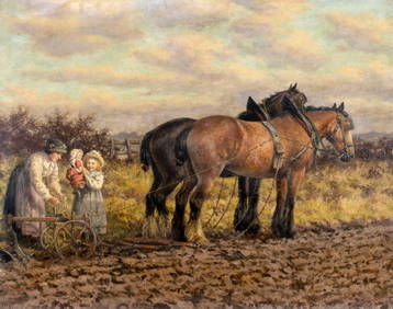
Dixon Clark (UK,1849-1944) oil painting antiqueBroward Auction Gallery4.8(277)See Sold PriceMar 31, 2024
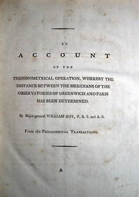
WILLIAM ROY Rare Navigation Book c1797 Trigonometry Between Paris & GreenwichLuis Porretta Fine Arts4.3(10)See Sold PriceMar 02, 2024
DEVINE c1856 Dr Salters Map Of Lake Huron Ontario Indian Lands etc. No. 7 ScarceLuis Porretta Fine Arts4.3(10)See Sold PriceMar 02, 2024
MATTHEWS c1856 Map Of Upper Canada Ontario Indian Land Agency Divisions Scarce!Luis Porretta Fine Arts4.3(10)See Sold PriceMar 02, 2024
DUNLEVIE c1856 Map Counties Of Gaspe & Bonaventure Quebec Canada SCARCE! #1Luis Porretta Fine Arts4.3(10)See Sold PriceMar 02, 2024
Dixon Clark (UK,1849-1944) oil painting antiqueBroward Auction Gallery4.8(277)See Sold PriceApr 14, 2024
1849 Mitchell School ATLAS 24 MAPS America Holy Land France Africa Egypt AsiaSchilb Antiquarian Rare Books4.8(421)See Sold PriceMar 31, 2024
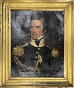
Portrait Study of Joseph P Traylor Attributed to Joshua HenshawChina Luban Art & Antique, Inc.4.4(78)See Sold PriceFeb 24, 2024
1849 THE NEW-ENGLAND MERCANTILE UNIONNorth American Artifact Auctions4.6(182)See Sold PriceApr 20, 2024
Matte Glaze Newcomb Baluster Vase, 1916, Cynthia Littlejohn, H.- 6 1/2 in., Dia.- 5 1/2 in.Crescent City Auction Gallery4.3(229)See Sold PriceMar 09, 2024
Joseph Meyer - Set of 12 Prints - Prag - Czech Republic - Germany - Buchberg - Nachod - JohannisbergProverde Auctions4.3(3)See Sold PriceFeb 28, 2024
Joseph Meyer - Set of 50 Prints - Views of Austria - Germany - Italy - Sweden - France - CzechProverde Auctions4.3(3)See Sold PriceFeb 28, 2024
Joseph Meyer - Set of 50 Prints - Views of Austria - Germany - Italy - Sweden - France - UnitedProverde Auctions4.3(3)See Sold PriceFeb 28, 2024
Joseph Meyer - Set of 20 Prints - Views of Austria - Germany - Italy - Torino - PisaProverde Auctions4.3(3)See Sold PriceFeb 28, 2024
Joseph Meyer - Set of 20 Prints - Views of Austria - Germany - Italy - Switzerland - France - SpainProverde Auctions4.3(3)See Sold PriceFeb 28, 2024