ATLAS of ANTIENT GEOGRAPHY by SAMUEL BUTLER 1843John McInnis Auctioneers,LLC4.6(504)See Sold PriceFeb 24, 2024
18TH C. ANTIQUE MAP: FRENCH & INDIAN WAR, FRAMEDThomaston Place Auction Galleries4.4(389)See Sold PriceFeb 24, 2024
Rand McNally Railroad Map Cabinet w/ 21 Railroad MapsRail & Road Auctions4.6(165)See Sold PriceMar 08, 2024
Keith Haring - Ink on New York Map, Best Buddies, Inscribed, Signed, and DatedSapphire Auction Gallery4.1(67)See Sold PriceMar 02, 2024
LATE 17TH C. FRENCH MAP OF THE NEW WORLD BY ALEXIS-HUBERT JAILLOT (1632-1712)Thomaston Place Auction Galleries4.4(389)See Sold PriceFeb 24, 2024
Central Railroad of New Jersey Map of Sandy Hook Route-ca. 1903JM Hobby Supply and Railroad Artifact Auctions4.4(126)See Sold PriceFeb 24, 2024
Lot of Six Mixed Atlas Box Cars-HO Scale-New in BoxJM Hobby Supply and Railroad Artifact Auctions4.4(126)See Sold PriceFeb 25, 2024
Rand McNally/Santa Fe Railroad Map of Iowa-1912JM Hobby Supply and Railroad Artifact Auctions4.4(126)See Sold PriceFeb 24, 2024
NICOLAES VISSCHER (NETHERLANDS, 1618-1709) MAP OF THE NEW WORLDThomaston Place Auction Galleries4.4(389)See Sold PriceFeb 24, 2024
17TH C. WORLD MAP BY NICOLAES VISSCHER (NETHERLANDS, 1618-1709)Thomaston Place Auction Galleries4.4(389)See Sold PriceFeb 24, 2024
Lot of Six Mixed Atlas Cabooses-HO Scale-New in BoxJM Hobby Supply and Railroad Artifact Auctions4.4(126)See Sold PriceFeb 25, 2024
SoldGrp: 10 Maps of ParisGroup of ten maps of Paris. Adolf Stieler Hand Colored Map of France "Sudwestliches Frankreich" from "Stieler's Hand Atlas" Gotha: Justus Perthes, 1871; City Plan of Paris "Plan von Paris" Published bSee Sold Price
SoldGrp: 10 Maps of New York City 18th-Early 20th c.Group of 18th to early 20th century maps of New York City. Multiple are 19th-20th c. reprints of 17th-18th c. maps. Includes a small census map of New York City from 1850 with populations of New YorkSee Sold Price
SoldGrp: 10 Maps of India and Sri LankaGroup of ten maps of India and Sri Lanka (Ceylon), by cartographers including Rigobert Bonne (1727-1795), Nicolaes Visscher I (1618-1679), and Jacques-Nicolas Bellin (1703-1772). Many of the maps featSee Sold Price
SoldGrp: 10 Maps of Africa 17th-19th c.Ten maps of Africa by cartographers including Pierre Duval (1618–1683), F. Von. Stulpnagel, Emanuel Bowen (1693-1767), and Abraham Ortelius (1527-1598). Includes three maps of Morocco and thSee Sold Price
SoldGrp: 10 Maps of British Cities w/ 1 Map VeniceGroup of maps of British cities. Includes one map of Birmingham; two road maps for the London area: "A Map of the New Roads & c. from Westminster Bridge" and "A Plan of the intended New Road from PadiSee Sold Price
SoldHenri Soules' Revolutionary War Map retracingUntitled Revolutionary War Map Showing Rochambeau’s March from Boston to the Chesapeake.Henri Soules (18th century). Engraved Map. Paris, 1787. 10 x 35 1/2 inches visible, 18 x 43 inches framed. FasSee Sold Price
SoldHenri Soules' Revolutionary War Map retracingUntitled Revolutionary War Map Showing Rochambeau’s March from Boston to the Chesapeake. Henri Soules (18th century). Engraved Map. Paris, 1787. 10 x 35 1/2 inches visible, 18 x 43 inches framed. FaSee Sold Price
SoldCollot Plan of Natchez, MSCOLLOT, George Henri Victor (1750-1805). Town and Fort of Natchez. Engraved Map. Paris, 1796-1826. 10" x 12 3/4" sheet. Probably the earliest map of Natchez, and the only one listed by Phillips.See Sold Price
SoldCollot Map Baton RougeCOLLOT, George Henri Victor (1750-1805). Plan of Fort Baton Rouge. Engraved Map. Paris, 1796-1826. 10" x 12 3/4" sheet. The First Map of Baton Rouge.See Sold Price
SoldCollot Plan of Vicksburg, MSCOLLOT, George Henri Victor (1750-1805). Plan of Nogales, Plate 32. Engraved Map. Paris, 1796-1826. 10" x 12 3/4" sheet. First printed plan of the site of Vicksburg, Mississippi.See Sold Price
1929 Map of ParisAuthor: Anonymous Title: 1929 Map of Paris Medium: Ink on Paper Dimensions: 10.5"X14.5" Map of Paris. Engraved for the Leipzig Institute of Bibliography. Published Berlin and Leipzig. Key lower left.See Sold Price
SoldDiderot, Suite de Receuil De Planches Sur les SciDiderot, Suite de Receuil De Planches Sur les Sciences, Paris, 1779, vol. III, with 10 maps, etc., plates include, architecture, music, atlas, surgery and militarySee Sold Price
SoldGrp: 10 Alexander Calder Books Derriere le MiroirGroup of ten issues of Derriere le Miroir about Alexander Calder, published Paris: Aime Maight, ca. 1950-1981. SKU: 03815See Sold Price
SoldAntique Map, Paris View from 1815Title/Content of Map: Paris view from 1815 Date Printed: 1815 Cartographer: Unknown Material/Medium: Paper Size: 10 1/2" x 8 1/3" Published in London Please note that this lot has a confidential reserSee Sold Price
SoldGrp: Maps of Greece and ItalyGroup of ten maps of Italy and Greece. Includes several maps from "Voyage in Italie," including Ravenna, Mantua; "Pianta della Citta di Pisa;" Map of Naples, Paris, 1705. "Cratere Maritimo, o Parte deSee Sold Price
SoldATLAS ILLUSTRE GEOGRAPHIE 10 CARTES, (1843).[Atlas]. Atlas Illustre Geographie Elementaire 10 Cartes. Maps by Jean-Guillaume Barbie du Bocage. Paris: Basset, c.1848 or later (some maps dated 1848). Tall 8vo. Astronomical plate + 9 maps: World,See Sold Price
SoldAdolphe Thiers (French, 1797-1877),Adolphe Thiers (French, 1797-1877), Atlas des Campagnes de la Revolution Francaise, 1846, Paris, Furne et Cie., thirty-two maps, 10-7/8" x 16-1/2", engraved by Charles Dyonnet (fl. 1838-1865), surveyeSee Sold Price
SoldAdolphe Thiers (French, 1797-1877)Adolphe Thiers (French, 1797-1877), Atlas des Campagnes de la Revolution Francaise, 1846, Paris, Furne et Cie., thirty-two maps, 10-7/8" x 16-1/2", engraved by Charles Dyonnet (fl. 1838-1865), surveyeSee Sold Price
SoldVuillemin, A 1848 Hand Colored Map of Paris, FranceHand Coloured Steel Engraved Map Published 1848, Paris for "La France et ses colonies" by Alexandre Vuillemin & Migeon. Paper Size: 13 x 10 inch (33 x 25cm) Good ConditionSee Sold Price
SoldGrp: 17 Maps from Nicolas Bellin "Le Petit AtlasThis lot includes 17 Jacques Nicolas Bellin (1703-1772) (Publisher: Didot, Paris) 18th Century Maps from "Le Petit Atlas Maritime Recueti de Cartes et Plans des Quatre Parlies du Monde en Cinq VolumesSee Sold Price
SoldGrp: Early Maps of North America w/ 1 Map EnglandGroup of early maps of North America with one map of England. Includes Louis Brion de la Tour (1743-1803), "Amerique Septentrionale, ou se remarquent les Etats Unis," Paris, 1779; John Melish (1771-18See Sold Price
Sold1901 Cram Map of Paris and Madrid -- Paris [verso]Title/Content of Map: 1901 Cram Map of Paris and Madrid -- Paris [verso] Madrid Date: 1901 Chicago Cartographer: G Cram Size: 13.1 x 10.1 in. This is a nice map of these two key West European capitalSee Sold Price
1901 Cram Map of Paris and Madrid -- Paris [verso]Title/Content of Map: 1901 Cram Map of Paris and Madrid -- Paris [verso] Madrid Date: 1901 Chicago Cartographer: G Cram Size: 13.1 x 10.1 in. This is a nice map of these two key West European capitalSee Sold Price
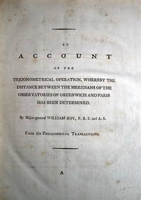
WILLIAM ROY Rare Navigation Book c1797 Trigonometry Between Paris & GreenwichLuis Porretta Fine Arts4.3(10)See Sold PriceMar 02, 2024
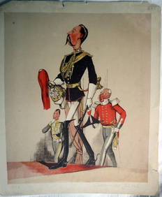
JOSEPH MARTIN KRONHEIM - "Captain Of The Blues" Early Colore Printing MilitaryLuis Porretta Fine Arts4.3(10)See Sold PriceMar 02, 2024
Collection of 10 Maps of Cities in Israel for TouristsLevy Auction House4.3(11)See Sold PriceFeb 27, 2024
1758 MAP PARTIE DE LA MER GLACIALE contenants La Nouvelle Zemble RUSSIA antiqueJasper524.5(9.8k)See Sold PriceFeb 27, 2024
1749 MAP CARTE DE LA TARTARIE ORIENTALE RUSSIA & CHINA antique EASTERN TARTARYJasper524.5(9.8k)See Sold PriceFeb 27, 2024
Geographical Statistical and Historical Map of the Windward IslandsJasper524.5(9.8k)See Sold PriceFeb 27, 2024
Barthelemy, Jean 1790 Map. Greece - Essa sur la Bataille de PlateeAlbion Auctions4.6(341)See Sold PriceMar 01, 2024
Barthelemy, Jean 1790 Map. Greece - Plan de L'AcademieAlbion Auctions4.6(341)See Sold PriceMar 01, 2024
Barthelemy, Jean 1790 Map. Greece - Essai sur les Environs de DelphesAlbion Auctions4.6(341)See Sold PriceMar 01, 2024
Denis Diderot (1713 - 1784) & Jean Le Rond d’Alembert (1717 - 1783) - Set of 10 Military Prints -Proverde Auctions4.3(3)See Sold PriceFeb 28, 2024
Denis Diderot (1713-1784) & Jean Le Rond d’Alembert - Set of 10 Military Prints - Empty frame [forProverde Auctions4.3(3)See Sold PriceFeb 28, 2024
Poster "Les jardins de Paris", illustrated map and plan of Paris with its parcs, gardens, monuments,Proverde Auctions4.3(3)See Sold PriceFeb 28, 2024
Jules Verne, De La Terre a La Lune, Au Steamer Red MacaronLion and Unicorn4.8(1.9k)See Sold PriceMar 10, 2024
Jules Verne, L'Archipel en Feu, Au Steamer Red MacaronLion and Unicorn4.8(1.9k)See Sold PriceMar 10, 2024
Jules Verne, L'Etoile du Sud, Au Steamer Red MacaronLion and Unicorn4.8(1.9k)See Sold PriceMar 10, 2024
Antique French Depose Frosted Glass Clock W/ BoxTom Hall Auctions Inc.4.4(113)See Sold PriceMar 04, 2024


![1901 Cram Map of Paris and Madrid -- Paris [verso] (1 of 2)](https://p1.liveauctioneers.com/5584/136888/69480755_1_x.jpg?height=282&quality=70&version=1551220587)
![1901 Cram Map of Paris and Madrid -- Paris [verso] (1 of 2)](https://p1.liveauctioneers.com/5584/128489/65352466_1_x.jpg?height=282&quality=70&version=1538523113)