ATLAS of ANTIENT GEOGRAPHY by SAMUEL BUTLER 1843John McInnis Auctioneers,LLC4.5(494)See Sold PriceFeb 24, 2024
18TH C. ANTIQUE MAP: FRENCH & INDIAN WAR, FRAMEDThomaston Place Auction Galleries4.4(386)See Sold PriceFeb 24, 2024
Rand McNally Railroad Map Cabinet w/ 21 Railroad MapsRail & Road Auctions4.6(165)See Sold PriceMar 08, 2024
Keith Haring - Ink on New York Map, Best Buddies, Inscribed, Signed, and DatedSapphire Auction Gallery3.9(67)See Sold PriceMar 02, 2024
LATE 17TH C. FRENCH MAP OF THE NEW WORLD BY ALEXIS-HUBERT JAILLOT (1632-1712)Thomaston Place Auction Galleries4.4(386)See Sold PriceFeb 24, 2024
Central Railroad of New Jersey Map of Sandy Hook Route-ca. 1903JM Hobby Supply and Railroad Artifact Auctions4.4(126)See Sold PriceFeb 24, 2024
Lot of Six Mixed Atlas Box Cars-HO Scale-New in BoxJM Hobby Supply and Railroad Artifact Auctions4.4(126)See Sold PriceFeb 25, 2024
Rand McNally/Santa Fe Railroad Map of Iowa-1912JM Hobby Supply and Railroad Artifact Auctions4.4(126)See Sold PriceFeb 24, 2024
NICOLAES VISSCHER (NETHERLANDS, 1618-1709) MAP OF THE NEW WORLDThomaston Place Auction Galleries4.4(386)See Sold PriceFeb 24, 2024
17TH C. WORLD MAP BY NICOLAES VISSCHER (NETHERLANDS, 1618-1709)Thomaston Place Auction Galleries4.4(386)See Sold PriceFeb 24, 2024
Lot of Six Mixed Atlas Cabooses-HO Scale-New in BoxJM Hobby Supply and Railroad Artifact Auctions4.4(126)See Sold PriceFeb 25, 2024
SoldRare 1st ed./1st state decorative map, 1848From the first comprehensive physical atlas of the world. This map comes from the rare first edition/first state of “Physikalischer Atlas oder Sammlung von Karten” by Heinrich Berghaus. Full titleSee Sold Price
SoldRare 1st ed/1st state NYC map by ColtonA rare and beautiful example of J. H. Colton map of New York City and vicinity, including Manhattan as well as parts of Brooklyn, Jersey City, Hoboken, and Queens. This is the first edition, first staSee Sold Price
SoldRARE GILMAN'S 1848 MAP OF THE USImportant and uncommon map - Ephraim Gilman’s 1848 Map of the United States, Now Expanded Coast to Coast. The map reflects President Polk's view that the best solution to the sectional crisis over sSee Sold Price
SoldRARE EARLY AMERICAN MAP"Ornamental Map of the United States & Mexico" sold by Sowle & Ward of Boston, published by Ensign & Thayer, 1848. Woodcut with hand coloring. A decorative broadside map produced during the Mexican-AmSee Sold Price
SoldR M Martin IRELAND BEFORE AND AFTER THE UNION WITHR M Martin IRELAND BEFORE AND AFTER THE UNION WITH GREAT BRITAIN 1848 Rare Decorative Fold-Out Map Statistical Table Irish History Exports Agriculture Finances Railways Commerce Banking Irish Church CSee Sold Price
SoldTallis, John. Mexico, California and Texas. London, ca.Tallis, John. Mexico, California and Texas. London, ca. 1848. Engraved map with coloured limits, 25x33 cm. 1st edition very rare.See Sold Price
SoldDe Cordova map of Texas 1849 1st edition RareHeading: Author: De Cordova, Jacob Title: J. De Cordova's Map of the State of Texas Compiled from the Records of the General Land Office of the State, by Robert Creuzbaur, Houston, 1849 Place PublishSee Sold Price
SoldRare 1st ed. map of Europe, Perthes 1847Rare ethnographic map of Europe in full color with full color key. Map comes from the rare 1845/48 first edition/first state of “Physikalischer Atlas oder Sammlung von Karten” by Heinrich BergSee Sold Price
Rare 1st ed. map of South America, Perthes 1847Full color ethnographic map of South America. Includes an inset map of the distribution of European languages throughout the continent. From the rare 1845/48 first edition/first state of “PhysikalSee Sold Price
Rare 1st ed. map of Africa, Perthes 1845Full color map of Africa by ethnography. With an inset map of Australia, Polynesia, and the Pacific Islands. From the rare 1845/48 first edition/first state of “Physikalischer Atlas oder Sammlung voSee Sold Price
[PRINT]. ENSIGNS. Ornamental Map.... 1848[PRINT]. ENSIGNS & THAYER (publishers). Ornamental Map of the United States & Mexico. [along bottom] Bowle and Ward, 43 Cornhill, Boston. Entered According to Act of Congress in the Year 1848,See Sold Price
SoldEpiphone United States Map Shaped Guitar DGUI37"Epiphone United States Map Shaped Guitar DGUI37. New Condition! GF123LQ. Epihone's rare United States map shaped size guitar is one of 200 made! Certainly unique, it has 2 humbucking pickups and tendSee Sold Price
SoldRARE MAP FOR PROPOSED 1896 MAINE ISLAND TENT RESORTNever realized plans for the "New England Tent Club Plan of Dirigo, Shown on Maps as Butter Island, State of Maine", dated January 1st, 1896. "For all information apply to Harriman Bros. Landscape EngSee Sold Price
Sold19th c 1st editions, rare imprints19th c 1st editions, rare imprints including 1839 Nicholas Nickleby by Charles Dickens Chapman & Hall, London (later state of the 1st edition), cover taped, 1853 Lines for the Gentle & Loving by ThomaSee Sold Price
SoldRare "Fredonia" folding map of U.S. 1848Title: Fredonia. Or the United States of North America; including also Cabotia, or the Canadian Provinces; The Western Territory To the Pacific Ocean' And the Northern Part of the Mexican States AuthoSee Sold Price
Battle of Cerro Gordo, 1848"The Battle of Thermopylae of the West" 141. [MAP]. UNITED STATES. ARMY. CORPS OF TOPOGRAPHICAL ENGINEERS. McCLELLAN, [George Brinton] & [William] Turnbull. Battle of Cerro Gordo April 1See Sold Price
Gilman, Map of U.S., ca. 1848The Cartographic Culmination of Manifest Destiny 146. [MAP]. UNITED STATES. GENERAL LAND OFFICE. GILMAN, E. [Untitled map of the United States showing boundaries after the Treaty of Guadalupe Hidalgo]See Sold Price
Battles of Mexico, 1848Rare Separate Issue on Thick Paper 139. [MAP]. UNITED STATES. ARMY. CORPS OF TOPOGRAPHICAL ENGINEERS. HARDCASTLE, [Edmund La Fayette], [George Brinton] McClellan & [William] Turnbull. Battles of MSee Sold Price
Sold1848 1st ed French ATLAS 95 Maps France Colonies1848 1st ed French ATLAS 95 Maps France Colonies Brittany Herault Illustrated A rare 19th-century French atlas published by Migeon and collected by Vuillemin. Each of these extremely desirable engraviSee Sold Price
SoldMapping the Golden State Through History, 1st EdTitle: Mapping the Golden State Through History. Rare and Unusual Maps from the Library of Congress Guilford. GPP. 2010 Author(s): Virga, Vincent California First edition. Condition: Fine copy in fineSee Sold Price
SoldRare early map showing United StatesHeading: Author: Stackhouse, Thomas Title: North America in its present Divisions, agreeable to the Peace Place Published: London Publisher:Published by T. Stackhouse Date Published: June 1sSee Sold Price
SoldCounty Map of the State of TexasCounty Map of the State of Texas, Samuel Augustus Mitchell Co., 1880. This decorative double-page colored county map has the attractively engraved grape vine border that characterized virtually all MiSee Sold Price
Sold(Western Exploration, United States), Abert, James(Western Exploration, United States), Abert, James W., Report and Map of the Examination of New Mexico, [Washington], 1848, included in the 1st Session of the 29th Congress, in later wraps, with largeSee Sold Price
Sold1811 MAP OF THE STATE OF PENNSYLVANIA HAND COLORED1811 MAP OF THE STATE OF PENNSYLVANIA: Powell, Reading (after); Philadelphia: Kimber & Conrad; Map engraved by J. Vallance, with decorative cartouches and inset view of the Schuylkill Permanent BridgeSee Sold Price
Crams Railroad Map of New York-1881JM Hobby Supply and Railroad Artifact Auctions4.4(126)See Sold PriceFeb 24, 2024
Crams Township and Railroad Map of New York-1890JM Hobby Supply and Railroad Artifact Auctions4.4(126)See Sold PriceFeb 24, 2024
ANNIE BEAN Breath of a ROSE 1916 1st Edition Rare Poetry Book Early CaliforniaLuis Porretta Fine Arts4.3(10)See Sold PriceMar 02, 2024
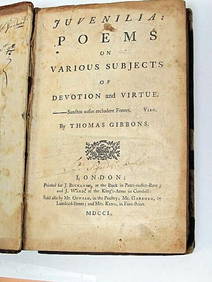
Thomas Gibbons Juvenalia 1750 Very Rare 1st Edition Full CalfLuis Porretta Fine Arts4.3(10)See Sold PriceMar 02, 2024
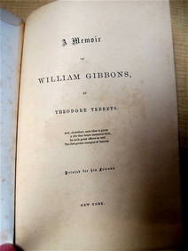
WILLIAM GIBBONS by Tebbets 1865 1st Ed. Rare Quaker Interest Signed by Author New YorkLuis Porretta Fine Arts4.3(10)See Sold PriceMar 02, 2024
ALEXANDER BALD 1780 1st Edition Scotland Corn Dealer Agriculture AssistantLuis Porretta Fine Arts4.3(10)See Sold PriceMar 02, 2024
JOHN FULTON Coke Coal Mining Rare c1895 1st Edition TreatiseLuis Porretta Fine Arts4.3(10)See Sold PriceMar 02, 2024
E M Forster Abinger Harvest True 1st Edition Dust Jacket - RARELuis Porretta Fine Arts4.3(10)See Sold PriceMar 02, 2024
1886 A Larger History of the United States 1st EditionNorth American Artifact Auctions4.7(175)See Sold PriceApr 20, 2024
[CHICAGO]. Rare Pre-Fire Illinois Map: “Blanchard’s Map of ...Potter & Potter Auctions4.6(538)See Sold PriceMar 07, 2024
Arrowsmith & Lewis - Map of the United StatesTrillium Antique Prints & Rare Books4.5(28)See Sold PriceFeb 24, 2024
Putnam - First Map of the State of Ohio by Rufus PutnamTrillium Antique Prints & Rare Books4.5(28)See Sold PriceFeb 24, 2024
Mitchell - Map of the City of Washington (Washington, DC)Trillium Antique Prints & Rare Books4.5(28)See Sold PriceFeb 24, 2024
Carey, pub. 1796 - Map of the State of MarylandTrillium Antique Prints & Rare Books4.5(28)See Sold PriceFeb 24, 2024
Carey, pub. 1796 - Map of The State of South CarolinaTrillium Antique Prints & Rare Books4.5(28)See Sold PriceFeb 24, 2024
Carey, pub. 1796 - Map of the Tennassee State formerly part of North Carolina (Tennessee)Trillium Antique Prints & Rare Books4.5(28)See Sold PriceFeb 24, 2024


![[PRINT]. ENSIGNS. Ornamental Map.... 1848 (1 of 3)](https://p1.liveauctioneers.com/514/95456/48680539_1_x.jpg?height=282&quality=70&version=1477936169)


![[CHICAGO]. Rare Pre-Fire Illinois Map: “Blanchard’s Map of ... (1 of 2)](https://p1.liveauctioneers.com/928/318880/171361260_1_x.jpg?height=282&quality=70&version=1707501302)


