Gothic Revival Stained Glass Window of The ResurrectionSchmidt's Antiques Inc. Since 19114.8(431)See Sold PriceMar 02, 2024
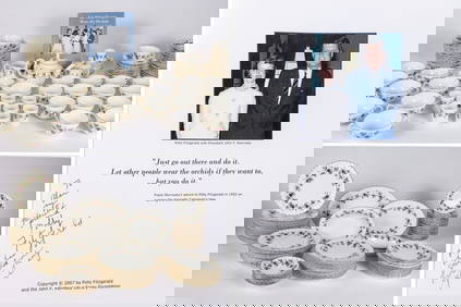
THE FITZGERALD FAMILY TEA and DINNER SERVICEJohn McInnis Auctioneers,LLC4.5(505)See Sold PriceFeb 25, 2024
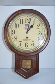
Union Pacific RR Cheyenne, WY Locomotive Shop ClockJM Hobby Supply and Railroad Artifact Auctions4.4(127)See Sold PriceFeb 24, 2024
A CHINESE PORCELAIN GREEN ENAMELED DRAGON MOON FLASK BIANHUBerkeley Auction Gallery4.4(16)See Sold PriceMar 03, 2024
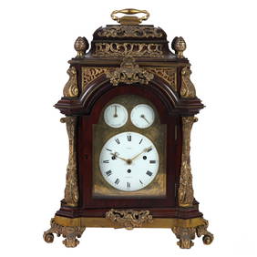
Antique George III Musical Bracket Clock by Hare LondonHill Auction Gallery 4.7(1k)See Sold PriceFeb 28, 2024
No Reserve Early 20th century French / Flemish Design Tapestry 6 ft 2 in x 4 ft 9 in (1.87 m x 1.44Nazmiyal Auctions4.4(34)See Sold PriceFeb 25, 2024
Central Anatolia Konya Antique Rug 4 ft 8 in x 3 ft 8 in (1.42 m x 1.11 m)Nazmiyal Auctions4.4(34)See Sold PriceFeb 25, 2024
PAIR MAGNIFICENT AND LARGE CLOISONNE ENAMEL CRANES INCENSE BURNERSBerkeley Auction Gallery4.4(16)See Sold PriceMar 03, 2024
From Davide Halevim Collection Antique Persian Mohtashem Kashan Rug 10'11" x 7'10" (3.32 m x 2.38 m)Nazmiyal Auctions4.4(34)See Sold PriceFeb 25, 2024
RARE COVENTRY GLASS WORKS MASONIC FLASKJohn McInnis Auctioneers,LLC4.5(505)See Sold PriceFeb 25, 2024
Empire by Buccellati Italy Sterling Silver Flatware Set 99 pieces DinnerBidhaus4.4(762)See Sold PriceFeb 25, 2024
SoldMap of Poland, Baltics and Sections of Russia byCopper plate, lightly hand-colored engraved map titled "Regni Poloniae et Ducatus Lithuaniae Voliniae, Podoliae Ucraniae..." by Frederick De Wit and published by De Wit circa 1680. Map is framed and mSee Sold Price
SoldLandkarte Map Poland Baltic States Russia18. Jh.-Kolorierte Landkarte mit Kartusche. 14 x 17,5 cm (53864004) - - Poland, Baltic States and western Russia. Coloured Map with cartouche. Image size: 14 x 17,5 cmSee Sold Price
1860 Map of Poland and RussiaAuthor: Stockley Title: 1860 Map of Poland and Russia Medium: Ink on Paper Dimensions: 9"X10.5" Map of Russia and Poland dated 1860. Engraved by James Stockley. Published by James Wyld engraver to QueSee Sold Price
Russia & Poland. Caucasus. Republics krais oblastsTITLE/CONTENT OF MAP: 'Russia & Poland' DATE PRINTED: 1896 IMAGE SIZE: Approx 65.5 x 52.5cm, 25.75 x 20.5 inches (Large); Please note that this is a folding map. TYPE: Large (folio) antique atlas mapSee Sold Price
SoldVaried Collection of Books - Complete and IncompleteVaried collection of books and book sections. Russia-Poland printings, Mussar and Halacha, the Vilna Gaon and his disciples, Kabbalah, Passover Haggadot etc. 23 items. For a complete list, please contSee Sold Price
SoldRussia, Poland, Finland Map Lithograph, 1897Russia, Poland, Finland Map Lithograph, 1897 Map 12â€Â x 16â€Â H **Age appropriate condition, as seen in photosSee Sold Price
Map of Russia Poland Sweden of NorwayMap of Russia Poland Sweden of Norway and Denmark in the end of XIV century. Print in 1850.Print of steel engraving titled „La Russie La Pologne la Suede la Norwege et le Danemarck a la fin du XIV sSee Sold Price
Map of Russia Poland Sweden of Norway and DenmarkMap of Russia Poland Sweden of Norway and Denmark in 1849. Print in 1850.Print of steel engraving titled „La Russie La Pologne la Suede la Norwege et le Danemarck en 1849.Author A. Houze.Engraved bySee Sold Price
Poland, Shewing the Claims of Russia, Prussia & AustriaTitle/Content of Map: Poland, Shewing the Claims of Russia, Prussia & Austria Cartographer: KITCHIN, T. ? Date: c1780 Size: 7.5Height - 8.5Width "from the best authorities." Folding illustration map pSee Sold Price
SoldGrp: 13 Maps from Herman Moll Atlas MinorGroup of twelve maps from Herman Moll's (ca. 1654-1732) "Atlas Minor," together with the colophon from the book. Includes maps of Hungary and Transylvania, Poland, Russia ("the Dominion of Muscovy"),See Sold Price
SoldTHREE 18TH CENTURY MAPS OF RUSSIA AND POLANDTHREE 18TH CENTURY MAPS OF RUSSIA AND POLAND. Comprising three maps of Russia, including 1775 Robert Sayer map entitled "The Russian Discoveries, from the Map Published by the Imperial Academy of St.See Sold Price
SoldMap of Poland, showing the Claims of Russia, PrussMap of Poland, showing the Claims of Russia, Prussia & Austria, until the late Depredations. "Engraved for Carey's American Edition of Guthrie's Geography improved" 4 1/2" tear in bottom center creaseSee Sold Price
1820 Map of Russia and PolandAuthor: Stockley Title: 1820 Map of Russia and Poland Medium: Ink on Paper Dimensions: 9"X10.5" Map of Russia and Poland dated 1820. Engraved by James Stockley. Published by James Wyld engraver to QueSee Sold Price
1860 Map of Russia and PolandAuthor: Stockley Title: 1860 Map of Russia and Poland Medium: Ink on Paper Dimensions: 9"X10.5" Map of Russia and Poland dated 1860. Engraved by James Stockley. Published by James Wyld engraver to QueSee Sold Price
Map of Russia and Poland. 1854.Print of hand colored steel engraving titled „Carte Physique et Politique de al Rissie de la Pologne”.Drawn by L. Dussieux.Engraved by unknown.From „Atlas General De Geographie physique, politiqSee Sold Price
1860 Map of Russia and PolandAuthor: Stockley Title: 1860 Map of Russia and Poland Medium: Ink on Paper Dimensions: 9"X10.5" Description: Map of Russia and Poland dated 1860. Engraved by James Stockley. Published by James Wyld enSee Sold Price
1860 Map of Russia and PolandAuthor: Stockley Title: 1860 Map of Russia and Poland Medium: Ink on Paper Dimensions: 9"X10.5" Map of Russia and Poland dated 1860. Engraved by James Stockley. Published by James Wyld engraver to QueSee Sold Price
1860 Map of Russia and PolandAuthor: Stockley Title: 1860 Map of Russia and Poland Materials: Ink on Paper Size/Dimensions: 9"X10.5" Description: Map of Russia and Poland dated 1860. Engraved by James Stockley. Published by JamesSee Sold Price
Thomson: Antique Map of European Russia, 1817Title/Content of Map: 'European Russia' including Baltics Belarus Ukraine Date Printed: 1817 Image Size: Approx 62.5 x 52.5cm, 24.75 x 20.75 inches (Large); Please note that this is a folding map. TypSee Sold Price
Sold1807 POLAND MAP C. BRIGHTLY & E. KENNERSTY BUNGAY1807 POLAND MAP C. BRIGHTLY & E. KENNERSTY BUNGAY Map of "Poland Shewing the Claims of Russia, Prussia, and Austria from the beft Authorities" by C. Brightly and E. Kennersty Bungay in Suffolk, April,See Sold Price
1807 POLAND MAP C. BRIGHTLY & E. KENNERSTY BUNGAY1807 POLAND MAP C. BRIGHTLY & E. KENNERSTY BUNGAY Map of "Poland Shewing the Claims of Russia, Prussia, and Austria from the beft Authorities" by C. Brightly and E. Kennersty Bungay in Suffolk, April,See Sold Price
Thomson: Antiuque Map of European Russia, 1817TITLE/CONTENT OF MAP: "European Russia" including Baltics Belarus Ukraine. DATE PRINTED: 1817 IMAGE SIZE: Approx 62.5 x 52.5cm, 24.75 x 20.75 inches (Large); Please note that this is a folding map. TYSee Sold Price
SoldMurray's Russia, Poland, and FinlandMurray (John, publisher) Handbook for Travellers in Russia, Poland, and Finland,folding map, plans, advertisements at end on blue paper, original limp cloth, recased, rubbed and faded, 1865; aSee Sold Price
1807 POLAND MAP C. BRIGHTLY & E. KENNERSTY BUNGAY1807 POLAND MAP C. BRIGHTLY & E. KENNERSTY BUNGAY Map of "Poland Shewing the Claims of Russia, Prussia, and Austria from the beft Authorities" by C. Brightly and E. Kennersty Bungay in Suffolk, April,See Sold Price
Joseph Biel (NY,Russia,1891-1943) oil painting antiqueBroward Auction Gallery4.7(292)See Sold PriceMar 10, 2024
Cleveland and Mahoning RR 2nd Annual Report-December 20, 1854JM Hobby Supply and Railroad Artifact Auctions4.4(127)See Sold PriceFeb 24, 2024
2 Early Postcards of Tel Aviv - Herzl & RothschildLevy Auction House4.3(11)See Sold PriceFeb 27, 2024
Nova Totius Full Color Geographical World MapThe Benefit Shop Foundation Inc.4.3(2.9k)See Sold PriceFeb 28, 2024
Joseph Biel, 1891-1943 (Belarus/France/Australia/USA)CULTURAL TRADITION4.3(5)See Sold PriceFeb 27, 2024
Johann Homann Hand-Colored Map Engraving, c. 1730Auctions at Showplace4.6(740)See Sold PriceMar 17, 2024
Duval - Pair: Map of Georgia & Map of Moscow, RussiaTrillium Antique Prints & Rare Books4.5(32)See Sold PriceFeb 24, 2024
1816 MAP SOUTHERN PART OF RUSSIA or MUSCOVY in EUROPE copper engraving ANTIQUEJasper524.5(9.9k)See Sold PriceFeb 27, 2024
1736 LARGE MAP OF SILESIA POLAND OPPAVIENSIS antique 25 by 34 3/4"Jasper524.5(9.9k)See Sold PriceFeb 27, 2024
1816 MAP NORTHERN PART OF RUSSIA or MUSCOVY in EUROPE copper engraving ANTIQUEJasper524.5(9.9k)See Sold PriceFeb 27, 2024
1736 LARGE MAP OF SILESIA POLAND KARNOVIENSIS antique 25 x 4 3/4" Duchy of KrnovJasper524.5(9.9k)See Sold PriceFeb 27, 2024
AFRICA shows 1911 Neukamerun border changes. Equatorial cross section 1912 mapJasper524.5(9.9k)See Sold PriceFeb 28, 2024
Antique Map of Poland, 1700 by Guillaume De Lisle, ParisAntiques Online Auctions4.6(415)See Sold PriceMar 14, 2024