ATLAS of ANTIENT GEOGRAPHY by SAMUEL BUTLER 1843John McInnis Auctioneers,LLC4.6(504)See Sold PriceFeb 24, 2024
18TH C. ANTIQUE MAP: FRENCH & INDIAN WAR, FRAMEDThomaston Place Auction Galleries4.4(389)See Sold PriceFeb 24, 2024
Rand McNally Railroad Map Cabinet w/ 21 Railroad MapsRail & Road Auctions4.6(165)See Sold PriceMar 08, 2024
Keith Haring - Ink on New York Map, Best Buddies, Inscribed, Signed, and DatedSapphire Auction Gallery4.1(67)See Sold PriceMar 02, 2024
LATE 17TH C. FRENCH MAP OF THE NEW WORLD BY ALEXIS-HUBERT JAILLOT (1632-1712)Thomaston Place Auction Galleries4.4(389)See Sold PriceFeb 24, 2024
Central Railroad of New Jersey Map of Sandy Hook Route-ca. 1903JM Hobby Supply and Railroad Artifact Auctions4.4(126)See Sold PriceFeb 24, 2024
Lot of Six Mixed Atlas Box Cars-HO Scale-New in BoxJM Hobby Supply and Railroad Artifact Auctions4.4(126)See Sold PriceFeb 25, 2024
Rand McNally/Santa Fe Railroad Map of Iowa-1912JM Hobby Supply and Railroad Artifact Auctions4.4(126)See Sold PriceFeb 24, 2024
NICOLAES VISSCHER (NETHERLANDS, 1618-1709) MAP OF THE NEW WORLDThomaston Place Auction Galleries4.4(389)See Sold PriceFeb 24, 2024
17TH C. WORLD MAP BY NICOLAES VISSCHER (NETHERLANDS, 1618-1709)Thomaston Place Auction Galleries4.4(389)See Sold PriceFeb 24, 2024
Lot of Six Mixed Atlas Cabooses-HO Scale-New in BoxJM Hobby Supply and Railroad Artifact Auctions4.4(126)See Sold PriceFeb 25, 2024
SoldFrance.- Paris.- [Vaugondy (Gilles Robert de)] PlanFrance.- Paris.- [Vaugondy (Gilles Robert de)] Plan Géométral de Paris et de ses Fauxbourgs..., large city plan of Paris centred on the Seine, with inset map of the environs of Paris, numeroSee Sold Price
[France Belgique Angleterre] Nicolas de FER - Lion Vill[France Belgique Angleterre] Nicolas de FER - Lion Ville tres considerable du Royaume de France [...] Paris, 1706. Plan gravé en couleurs. 240 x 350 mm. JOINTS: - [ROBERT de VAUGONDY] - Carte partiSee Sold Price
SoldFrance.- Brittany.- Vaugondy (Gilles Robert de) CarteFrance.- Brittany.- Vaugondy (Gilles Robert de) Carte du Gouvernement de Bretagne, engraved map with some outline hand-colouring on laid paper, platemark 525 x 710 mm. (20 3/4 x 28 in), sheet 565 x 78See Sold Price
SoldLes Indes Orientales Ou Sount Distingues Les Empires etGilles Robert de Vaugondy. Paris: Vangundy, 1755. Engraved map with original hand color in outline. 26 x 19 1/2 inches sheet. A crisply engraved map describing India, Thailand, Cambodia, Vietnam, MalaSee Sold Price
SoldMAP C. 1765, SWEDEN & NORWAY, VAUGONDY & GIBSONFramed map, c. 1765, "A New and Accurate Map of Sweden and Norway from the Sieur Roberts Atlas with Improvements", Sr. Robert (Gilles Robert de Vaugondy, France,1688–1766), J. Gibson Engraver (See Sold Price
16 18th C ROBERT DE VAUGONDY ENGRAVED MAPSA lot of 16 18th century Robert de Gilles Vaugondy (FRANCE, 1688–1766) engraved maps. Each measures approx. 21" height x 29" width (53.3cm x 73.6cm).See Sold Price
La Royaume de Boheme le Duch de Silesiae et les"La Royaume de Boheme le Duch de Silesiae et les Marqisats de Moravie et Lusace. Grenzkol. Kupferstichkarte von Gilles Robert De Vaugondy. Paris dat. 1751. Plattenmae ca. 50 x 58 cm. Mit TitelkartuschSee Sold Price
SoldLes Indes Orientales en-desa du Ganges[,] pour ServirBy Robert (Gilles Robert de Vaugondy), [Paris], 176237.5 cm x 30.5 cm Watermarked paper (“P PRAT[,] AGENOIS”). Clear, clean impression. Very attractive cartouche of baroque frame with flowers.See Sold Price
SoldGilles Robert De Vaugondy (1688-1766, Paris), "La JudeeGilles Robert De Vaugondy (1688-1766, Paris), "La Judee Depuis le Retour la Captive.. Supplement l'Atlas Vaugondi (insets),"1786, H. - 22 in., W. - 30 1/2 in.See Sold Price
SoldRobert de Vaugondy, World Map ‘Mappe Monde’, Paris,Copperplate map, colored in outlines on laid/wove paper (watermark paw cross in wreath and writing) France, Paris, 1786 Robert de Vaugondy (1688-1766) – French cartographer Publisher: Charles FrancoSee Sold Price
[France] Gilles ROBERT DE VAUGONDY - Comtés de[France] Gilles ROBERT DE VAUGONDY - Comtés de Hainaut, et de Cambrésis avec les confins du comté de Flandre, du duché de Brabant, du comté de Namur, et une partie de la seigneurie de LSee Sold Price
SoldCounts of Hainaut and Cambresis. VaugondyComtes de Hainaut, et de Cambresis, avec les confins Du Comte.... Maker: Robert de Vaugondy, Gilles. Origin: Paris, 1754 Medium: Original engraving with early hand-coloring. Sheet size: 22 x 29 1/2 inSee Sold Price
Sold(2) 18TH CENTURY FRENCH & GERMAN MAPS(lot of 2) Maps; (1) framed map from the "Atlas Universal" by Gilles Robert de Vaugondy and son (France, c.1723-1786), entitled "Gouvernement General de L'Isle de France, divise par Pays, Par le Sr. RSee Sold Price
MAP, Northern France, Robert de VaugondyNorthern France. Gilles Robert de Vaugondy, Partie Septentrionale du Gouvernem? General de Champagne ou se Trouvent le Retelois, le Rhemois, la Champagne Propre, Partie de la Brie et du Pertois, &c.,See Sold Price
Sold[VAUGONDY, Gilles Robert de (1688-1766)] - Una serie di[VAUGONDY, Gilles Robert de (1688-1766)] - Una serie di tavole dall'Atlas Universel, alcune colorate nei contorni all'epoca. [Paris: XVIII secolo]. (515 x 682mm). The maps are the following: Isles deSee Sold Price
SoldROBERT de VAUGONDY, GILLES Map.ROBERT de VAUGONDY, GILLES: Environs de Paris, Par Le Sr. Robert Geographe Ordinaire Du Roi with Privileged 1753 Hand-colored double-page engraved map of the country surrounding Paris. 20 ¼ x 2See Sold Price
SoldGilles Robert de Vaugondy (1688-1766), "Environs ofGilles Robert de Vaugondy (1688-1766), "Environs of Paris," 1753, hand colored, H.- 20 1/2 in., W.- 26 1/2 in.See Sold Price
SoldA Hand Colored Map on Laid Paper of 'Royaume D'Irlande'A Hand Colored Map on Laid Paper of 'Royaume D'Irlande' by Gilles Robert de Vaugondy (1688-1766), Published in Paris, ca. 1750. Framed dimensions: h: 29 1/4 x w: 30 5/8 in. H: 19 14 W: 21 1/2 in. TheSee Sold Price
A Hand Colored Map on Laid Paper of 'Royaume D'Irlande'A Hand Colored Map on Laid Paper of 'Royaume D'Irlande' by Gilles Robert de Vaugondy (1688-1766), Published in Paris, ca. 1750. Framed dimensions: h: 29 1/4 x w: 30 5/8 in. H: 19 14 W: 21 1/2 in. TheSee Sold Price
SoldVaugondy, Empire de la Chine. 1749Gilles Robert de Vaugondy, Empire de la Chine. Paris, 1749. Impression measures 7x8.25'' on 8.5x11.75'' sheet. (84)See Sold Price
Robert de Vaugondy, Gilles : Landkarte von BayernRobert de Vaugondy, Gilles : Map of Bavaria (France 1688-1766) ''Le cercle de Bavière...''. Copper engraving with area and border colouring. Visible size 50,5 x 46 cm; in passepartout and framed unSee Sold Price
SoldVaugondy, L'Empire de la Chine. Paris, 1751Gilles Robert de Vaugondy, L'Empire de la Chine. Paris, 1751. Outline coloring of provinces. Impression measures 19.5x21.5'' on 20.5x27.5'' sheet. Toning in margins around edges. (109)See Sold Price
Vaugondy Amerique SepentrionaleAmerique Septentrionale. Didier Robert de Vaugondy (1723-1786) & Gilles Robert de Vaugondy (1688-1766). Engraved map with hand color in outline. Paris, 1750. 21 1/2 x 32 1/2 inches sheet.See Sold Price
Gouvernement General De L'isle De France Divise ParTitle/Content of Map: Gouvernement General De L'isle De France Divise Par Pays. Cartographer: ROBERT DE VAUGONDY, GILLES (1686-1766) Date: 1754 Publisher: ROBERT DE VAUGONDY Size: 18.75Height - 20.5WiSee Sold Price
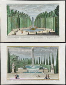
Demortain - 4 Fountain & Garden EngravingsTrillium Antique Prints & Rare Books4.5(30)See Sold PriceFeb 24, 2024
R. Crumb (American, b. 1943) Robert Johnson, 1988Freeman's | Hindman4.4(1.6k)See Sold PriceMar 07, 2024
Kees Van Dongen - Chanteurs des rues, ou le reve a bon marche, 1949NCAG4.4(32)See Sold PriceMar 10, 2024
Kees Van Dongen - Van Dongen et Roland Dorgeles, Le Marche de la rue des Abbesses, 1949NCAG4.4(32)See Sold PriceMar 10, 2024
Kees Van Dongen - La soiree au "Lapin Agile" lorsque Frede chantait, 1949NCAG4.4(32)See Sold PriceMar 10, 2024
Robert de Vaugondy - Map of Canada - Mer de l' Ouest or Sea of the West and a Northwest PassageProverde Auctions4.3(3)See Sold PriceFeb 28, 2024
![France.- Paris.- [Vaugondy (Gilles Robert de)] Plan First Image](https://p1.liveauctioneers.com/5458/156131/78785244_1_x.jpg?height=282&quality=95&version=1574849334&width=282)

![France.- Paris.- [Vaugondy (Gilles Robert de)] Plan First Image](https://p1.liveauctioneers.com/5458/156131/78785244_1_x.jpg?height=282&quality=1&version=1574849334&width=282)


![France.- Paris.- [Vaugondy (Gilles Robert de)] Plan (1 of 1)](https://p1.liveauctioneers.com/5458/156131/78785244_1_x.jpg?height=282&quality=70&version=1574849334)
![[France Belgique Angleterre] Nicolas de FER - Lion Vill (1 of 3)](https://p1.liveauctioneers.com/828/70915/36353161_1_x.jpg?height=282&quality=70&version=1429545165)


![Les Indes Orientales en-desa du Ganges[,] pour Servir (1 of 1)](https://p1.liveauctioneers.com/6940/190006/95714350_1_x.jpg?height=282&quality=70&version=1609440753)


![[France] Gilles ROBERT DE VAUGONDY - Comtés de (1 of 1)](https://p1.liveauctioneers.com/828/70915/36353159_1_x.jpg?height=282&quality=70&version=1429545165)


![[VAUGONDY, Gilles Robert de (1688-1766)] - Una serie di (1 of 1)](https://p1.liveauctioneers.com/3662/175274/88222580_1_x.jpg?height=282&quality=70&version=1597918246)