SoldEarly Map of Philadelphia.Map titled "Plan of the City of Philadelphia" engraved by William Barker. Map measures 10.75" x 12.5" (plate mark) and exhibits some toning. Late 18th, early 19th century. Framed.See Sold Price
SoldAN EARLY ENGRAVED MAP OF PHILADELPHIA, NICHOLAS SCULL,AN EARLY ENGRAVED MAP OF PHILADELPHIA, NICHOLAS SCULL, 1762 To the Mayor, Recorder, Aldermen, Common Council and Freemen of Philadelphia this plan of the improved part of the city, surveyed and laid dSee Sold Price
Sold1818 Map of OhioFine and early map by John Melish, 1818 Publication info. Philadelphia: John Melish 1818 Original cost $800. Size 9 x 9 sight, Frame 16 x 15.See Sold Price
SoldEarly Map of The Michigan Territory by CareyThe Upper Territories of the United States, 1814. Matthew Carey (1760-1839). Engraved map with original hand color in outline. Philadelphia, 1814. 22 x 17 1/4 inches sheet. The map reflects a very earSee Sold Price
SoldEARLY MAP OF NORTHEAST & NEW YORKby Nicholas Visscher, ‘NOVI BELGII NOVAEQUE ANGLIAE…’, Amsterdam, 1684 (this being the third edition with Philadelphia added for the first time), engraving with hand-coloring. h. 21 w. 25 in. (sSee Sold Price
SoldVery Early Map of North CarolinaVery Early Map of North Carolinafrom American Pocket Atlas (Philadelphia: Matthew Carey, 1801), copperplate engraving by W. Barker, with outline color. Presented behind a mat. Sheet 8 x 9 in. AdditioSee Sold Price
SoldEarly Map Of New YorkEarly map of New York. Published by H.S. Tanner, Philadelphia, Engraved by W. Brose, Philadelphia. Sight 11 1/2" x 13".See Sold Price
SoldEarly Map1858 Dutchess County map. John Gillette Publisher....Philadelphia. As found.See Sold Price
SoldTwo Early Map and Geography Books1909 copy of Baedeker's United States, with 33 old colored maps and 48 plans, as well as a copy of Warren's Brief Course in Geography published by Cowperthwait & Co Philadelphia; Baedeker's book retaiSee Sold Price
SoldTwo Early Maps"J. Churchill Dacuerrean Artist Delhi" (one) states "1856 Delaware Co. Map of New York from actual Survey by Jay Gould Published by Collins G. Keeney No 17 & 19 Minor St. Philadelphia." Paper on canvaSee Sold Price
1827 Carey & Lea Ohio Map -- Geographical, StatisticalCarey & Lea, 1827, Philadelphia, 17 x 21.8 in. with text panels This early map of Ohio is on a full folio sheet with English text below and on sides concerning the state's topography, climate, populatSee Sold Price
Sold(5) EARLY LOOSE MAPS & BROCHURESIncluding: "Map of the Oil District of West Virginia", Compiled and Drawn by Peter F. Straut, Publisehed by R. L. Barnes, Philadelphia, No 7., 1864, Hackingport to Ritchie C.H., 16" x 19", beginning tSee Sold Price
SoldEARLY FRAMED MAP OF MISSOURI BY FINLEYEARLY FRAMED MAP OF MISSOURI BY FINLEYPublished by A. Finley, Philadelphia, ca.1824. Local historic significance as the earliest map of Missouri published upon gaining statehood. Early depictions of SSee Sold Price
Sold(2) EARLY 1800'S MAPS OF DELAWAREIncludes: "Geographical, Historical, and Statistical Map of Delaware"; pencil writing identifies it as from Delaware - Carey and Lea, Philadelphia, 1822, (page 19); drawn by F. Lucas Jr., Engraved bySee Sold Price
SoldThree Early American Maps"Tennasee (sic) lately the S.Wn. Territory" from "Cary's American Pocket Atlas", Philadelphia, 1801, 8 x 6-1/2 in. (sight), matted with gilt painted frame, sun exposure at center fold; "Tennessee" MapSee Sold Price
SoldLate 19thc Early 20thc Maps of AsiaTwo maps of Asia from the late 19th century. Book atlas maps. One of them marked pg. 74 from an 1874 edition of a text book entitled, "A Brief Course In Geography" published in Philadelphia by CowpertSee Sold Price
SoldBradford: Antique Map of Early American Cities, 1835Title/Content of Map: Early American Cities: New York, Portland (MI), Boston, Providence, Baltimore, Albany, Philadelphia, Charleston, Savanna, New Orleans, St. Louis, Louisville, Nashville, CincinnatSee Sold Price
Sold"A Map of Old Philadelphia…..", 1932"A Map of Old Philadelphia on which are indicated Buildings of Architectural Interest that were built during the 18th and early 19th Centuries and are still standing AD 1932, Two Hundred and Fifty YeaSee Sold Price
SoldAn Early 20th Century Map of Chestnut HillA map from an unknown atlas of Chestnut Hill, a neighborhood in Philadelphia. W. Graham Arader III tag at the reverse. Dimensions: Sight is 17 1/4" x 27", the frame 23 1/2" x 33".See Sold Price
SoldEARLY OHIO TRAVELLER'S MAP.EARLY OHIO TRAVELLER'S MAP. Tanner's Traveller's Map of Ohio, engraved by E.B. Dawson, published by H.S. Tanner, Philadelphia, 1836, with steamboat routes and a "Profile of the Ohio Canal". Light toniSee Sold Price
SoldHoly Bible, Philadelphia 1813"The Holy Bible: Containing the Old and New Testaments: Together with the Apocrypha" (Philadelphia, M. Carey 1813); contemporary calf; With two folding maps, an early Bible imprint to contain the ApocSee Sold Price
SoldA GROUP OF TWO ANTIQUE MAPS OF THE STATE OF TEXAS,A GROUP OF TWO ANTIQUE MAPS OF THE STATE OF TEXAS, AMERICAN, EARLY 20TH CENTURY,   "No. 13 Map of the State of Texas," Philadelphia, circa 1912, hand colored engraving on paper, a page fragment fSee Sold Price
SoldJOHN MELISH (SCOTLAND/AMERICAN 1771-1822), EARLY ANDJOHN MELISH (SCOTLAND/AMERICAN 1771-1822), EARLY AND RARE MAP OF THE UNITED STATES OF AMERICA, C.1813. ENTERED AS THE ACT DIRECTS AND PUBLISHED BY JOHN MELISH, PHILADELPHIA, JUNE 1813. SIGHT 13 X 17 1See Sold Price
Sold[America, Maps] 3 city maps, about 1910SCARCE EDITIONS OF EARLY 1900 OF THREE HANDY MAPS OF USA CITIES (NEW YORK, PHILADELPHIA AND NEW ORLEANS) [1.]: Rand, McNally Co.. New handy map of New York City with a large scale map of the borough oSee Sold Price
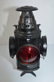
Philadelphia and Reading RY Dressel Switch LampJM Hobby Supply and Railroad Artifact Auctions4.4(126)See Sold PriceFeb 24, 2024
Carey, pub. 1796 - A Chart of the West IndiesTrillium Antique Prints & Rare Books4.5(30)See Sold PriceFeb 24, 2024
Carey, pub. 1796 - Map of the State of MarylandTrillium Antique Prints & Rare Books4.5(30)See Sold PriceFeb 24, 2024
Carey, pub. 1796 - Map of GeorgiaTrillium Antique Prints & Rare Books4.5(30)See Sold PriceFeb 24, 2024
Carey, pub. 1796 - Map of The State of South CarolinaTrillium Antique Prints & Rare Books4.5(30)See Sold PriceFeb 24, 2024
Carey, pub. 1796 - Map of KentuckyTrillium Antique Prints & Rare Books4.5(30)See Sold PriceFeb 24, 2024
Carey, pub. 1796 - Map of the Tennassee State formerly part of North Carolina (Tennessee)Trillium Antique Prints & Rare Books4.5(30)See Sold PriceFeb 24, 2024
1856 ARCTIC EXPLORATIONS 2nd GRINNEL EXPEDITION 2 v. E.KANE antique ILLUSTRATEDJasper524.5(9.8k)See Sold PriceFeb 27, 2024
WEST AFRICA Explorers' routes Senegal Ashanti. Mountains of Kong. SDUK 1857 mapJasper524.5(9.8k)See Sold PriceFeb 28, 2024
AFRICA. Map pre-dating much exploration. Mountains of Kong. SDUK 1851 oldJasper524.5(9.8k)See Sold PriceFeb 28, 2024
THE ANTIQUE ILLUSTRATED BOOK "1856 ARCTIC EXPLORATIONS: SECOND GIRNEL EXPEDITION 2" BY E. KANENY Elizabeth 4.3(84)See Sold PriceMar 03, 2024


![[America, Maps] 3 city maps, about 1910 (1 of 10)](https://p1.liveauctioneers.com/2198/56199/31005028_1_x.jpg?height=282&quality=70&version=1415833748)