ATLAS of ANTIENT GEOGRAPHY by SAMUEL BUTLER 1843John McInnis Auctioneers,LLC4.6(504)See Sold PriceFeb 24, 2024
18TH C. ANTIQUE MAP: FRENCH & INDIAN WAR, FRAMEDThomaston Place Auction Galleries4.4(389)See Sold PriceFeb 24, 2024
Rand McNally Railroad Map Cabinet w/ 21 Railroad MapsRail & Road Auctions4.6(165)See Sold PriceMar 08, 2024
Keith Haring - Ink on New York Map, Best Buddies, Inscribed, Signed, and DatedSapphire Auction Gallery4.1(67)See Sold PriceMar 02, 2024
LATE 17TH C. FRENCH MAP OF THE NEW WORLD BY ALEXIS-HUBERT JAILLOT (1632-1712)Thomaston Place Auction Galleries4.4(389)See Sold PriceFeb 24, 2024
Central Railroad of New Jersey Map of Sandy Hook Route-ca. 1903JM Hobby Supply and Railroad Artifact Auctions4.4(126)See Sold PriceFeb 24, 2024
Lot of Six Mixed Atlas Box Cars-HO Scale-New in BoxJM Hobby Supply and Railroad Artifact Auctions4.4(126)See Sold PriceFeb 25, 2024
Rand McNally/Santa Fe Railroad Map of Iowa-1912JM Hobby Supply and Railroad Artifact Auctions4.4(126)See Sold PriceFeb 24, 2024
NICOLAES VISSCHER (NETHERLANDS, 1618-1709) MAP OF THE NEW WORLDThomaston Place Auction Galleries4.4(389)See Sold PriceFeb 24, 2024
17TH C. WORLD MAP BY NICOLAES VISSCHER (NETHERLANDS, 1618-1709)Thomaston Place Auction Galleries4.4(389)See Sold PriceFeb 24, 2024
Lot of Six Mixed Atlas Cabooses-HO Scale-New in BoxJM Hobby Supply and Railroad Artifact Auctions4.4(126)See Sold PriceFeb 25, 2024
Sold(5) EARLY LOOSE MAPS & BROCHURESIncluding: "Map of the Oil District of West Virginia", Compiled and Drawn by Peter F. Straut, Publisehed by R. L. Barnes, Philadelphia, No 7., 1864, Hackingport to Ritchie C.H., 16" x 19", beginning tSee Sold Price
SoldEarly Map of ItalyAn early map of Italy. Loose, unframed and not glued or mounted, etc. Image size 10 3/8" x 8 7/8" (26.5cm x 22.5cm). Sheet size 14 5/8" x 13" (37cm x 33cm). Very good condition. This plate is shown inSee Sold Price
SoldEarly CCM Bicycle CataloguesThree (3). Canadian. Largest 8.25" x 6.5". Includes 1903 CCM Dominion Exhibition Map, 1907 Welland Vale Bicycles Brochure and 1919 CCM "Perfect" bicycles brochure.See Sold Price
SoldEarly Engraving Hand-Colored [Map, People]Early engraving hand-colored. Image measures 7 in. x 8.25 in. and sheet measures 8.5 in. x 11.5 in. Unframed, loose and not glued or mounted. If lot is absent of a condition report one may be requesteSee Sold Price
SoldAlbum containing 33 pcs of ephemera related toDighton, MA, to include: 3 vintage maps taken from an early map book, brochures for Mt Hope finishing Co. , Dighton Unitarian cemetery, stereoptic card of Berkley Bridge, Dighton Bi-centennial celebraSee Sold Price
Walch: Antique Map of the Northern Hemisphere, 1787Title/Content of Map: [Untitled Map of the Northern Hemisphere] Date Printed: 1787 Cartographer: Walch Size: 9" x 7.5" Rare early map of the Northern Hemisphere, one of the earliest maps engraved by WSee Sold Price
SoldLARGE LOT of VINTAGE TRANSPORTATION EPHEMERANice lot includes Auto, Boat, and Bicycle brochures. Also included are early auto maps, brochures for auto parts, railroad ephemera and more. Condition varies. Very Good-ExcellentSee Sold Price
Map of Tuscia (Tuscany) Gerard MercatorTuscia (Tuscany). Maker: Gerard Mercator - Jodocus Hondius. Date: 1619. Size: sheet 18.5" x 22.5". This early map of Tuscany is from Gerardi Mercatoris - Atlas sive Cosmographicae, published by the HoSee Sold Price
Sold5 Copies of Early Maps by Penn Prints, New York.Five Copies of Early Maps by Penn Prints, New York. All are framed and measure 15-3/4" x 20-1/2" overall. Condition: Good with light foxing.See Sold Price
(5) EARLY FRAMED BRITISH MAPS & COAT OF ARMS(lot of 5) Framed English color maps, originally in a bound book, likely 18th c., showing the coat of arms and regions of Rippon, Scarborough, Pontefract, the Bishoprick of Durham and Stamford, set inSee Sold Price
SoldAUTO UNION 5 brochures, early '50s, DKW Meisterklasse,AUTO UNION 5 brochures, early '50s, DKW Meisterklasse, all with German text, condition: 2- German Description AUTO UNION 5 Prospekte, Anfang 50er Jahre, DKW Meisterklasse, alles deutscher Text, ZustanSee Sold Price
Map of EnglandTitle: Map of England Medium: Ink on Paper Dimensions: 11" X 10.5" Early 18th century map of Great Britain in the 11th century. Engraved by James Lodge. Includes information about the country before tSee Sold Price
SoldBMW mixed lot of 5 pieces, early '60s, brochures/oneBMW mixed lot of 5 pieces, early '60s, brochures/one page flyers "Die Neue Klasse" BMW 1500, all with German text, condition 2 German Description BMW Konv. 5tlg., Anfang 60er Jahre, Prospekte/EinblattSee Sold Price
SoldLot of Early Travel Brochures, Maps and PostcardsLot of Early Travel Brochures, Guides, Maps and Postcards; includes (28) different pieces from all over the world; includes many Bartholomew's Guides including Tourists & Cyclists, Edinburgh District,See Sold Price
SoldVW Mixed lot of 5-pieces, brochures, early '50s, inVW Mixed lot of 5-pieces, brochures, early '50s, in German and English text, condition 2 German Description VW, Konv. 5-teilig, Prospekte, Anfang 50er Jahre, deutsch und englischer Text, Zust. 2See Sold Price
SoldBible, English. The Holy Bible, 1679Bible, English. The Holy Bible, engraved title (cut down, loose), 5 engraved map (some defects), contemporary leather over wooden boards, worn and defective, 1679 § Link (Karl) Passions-TypenSee Sold Price
SoldCunard and Anchor Lines ephemeraCunard and Anchor Lines ephemera including booklets, brochures, maps, ship diagrams, early 1900'sSee Sold Price
Bradford: Map of Massachusetts,1835Map: Massachusetts Maker: Bradford Date: 1835 Size: 7.5 x 10 inches Nice early map of the state of Massachusetts by Thomas Gamaliel Bradford. Original hand coloring. Clean with good margins. Please noSee Sold Price
Sold3 color atlases, 1892-1902. Century, Popular, Chi[Atlases]. 3 Atlases. 4to/Folio. ++ The Century Atlas Of The World. Vol X of Century Dictionary. NY: (1897). Publisher's 3/4 morocco. Front joint starting, lacking Map 5, Map 1 loose and edge frayed,See Sold Price
Sold3 color atlases, 1892-1902. Century, Popular, Chi[Atlases]. 3 Atlases. 4to/Folio. Hardcover. Good - very good. ++ The Century Atlas Of The World. Vol X of Century Dictionary. NY: (1897). Publisher's 3/4 morocco. Lacking Map 5, Map 1 loose and edge fSee Sold Price
SoldCharles Launay 1720 ''Typus Orbis Terrarum'' World MapCharles Launay 1720 ''Typus Orbis Terrarum'' World Map 7.5''x9'' Sheet. An early hand colored map engraving. Some ink writing in margin. Impression size 5''x8''.Trimmed right margin with some toning.See Sold Price
SoldWhiting & Davis Mesh PurseWhiting & Davis Mesh Purse, Art Deco silvered and cornelian enameled frame with marcasite and matching chain, multi colored mesh with fringe, small round interior loose mirror, early 20th C, 5" x 8".See Sold Price
SoldBetty Valentine Queen Anne ChairsThree Queen Anne side chairs with pad feet 3.5" H, early work with rough finish. Loose seats covered in silk.See Sold Price
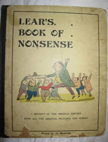
EDWARD LEAR Book Of Nonsense Early ca1890 Routledge Printing RareLuis Porretta Fine Arts4.3(10)See Sold PriceMar 02, 2024
ANNIE BEAN Breath of a ROSE 1916 1st Edition Rare Poetry Book Early CaliforniaLuis Porretta Fine Arts4.3(10)See Sold PriceMar 02, 2024
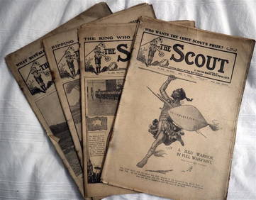
The SCOUT MAGAZINE Rare c1912 5 x Issues RARE!Luis Porretta Fine Arts4.3(10)See Sold PriceMar 02, 2024
An Early "Welcome to Disneyland" Main Gate Brochure.Van Eaton Galleries4.6(99)See Sold PriceMar 02, 2024
A 1975 Walt Disney World Magic Kingdom Souvenir Map.Van Eaton Galleries4.6(99)See Sold PriceMar 02, 2024
[EARLY PHOTOGRAPHY]. Tintype of an African American couple in an outdoor setting.Freeman's | Hindman4.4(1.6k)See Sold PriceFeb 27, 2024
1856 ARCTIC EXPLORATIONS 2nd GRINNEL EXPEDITION 2 v. E.KANE antique ILLUSTRATEDJasper524.5(9.8k)See Sold PriceFeb 27, 2024
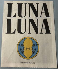
LUNA LUNA - OFFICAL PROGRAM (HARING, BASQUIAT, LICHTENSTEIN, DALI)ArtMeetsStreet x Mercer Auctions4.4(44)See Sold PriceMar 02, 2024
SOUTH CENTRAL AFRICA. Shows Zambesi river as circular! WELLER 1863 old mapJasper524.5(9.8k)See Sold PriceFeb 28, 2024
Western Africa by Edward Weller. Early British/French settlements 1860 old mapJasper524.5(9.8k)See Sold PriceFeb 28, 2024
WEST AFRICA II. NIGERIA. Bight of Benin-Lake Chad. Yariba Houssa. SDUK 1851 mapJasper524.5(9.8k)See Sold PriceFeb 28, 2024
NIGERIA early explorers' routes. Lake Chad. Yariba Houssa Borgou SDUK 1844 mapJasper524.5(9.8k)See Sold PriceFeb 28, 2024
NIGERIA w/ early explorers' routes. Lake Chad Yariba Houssa Borgou.SDUK 1844 mapJasper524.5(9.8k)See Sold PriceFeb 28, 2024
Western Africa by Edward Weller. Early British/French settlements 1859 old mapJasper524.5(9.8k)See Sold PriceFeb 28, 2024
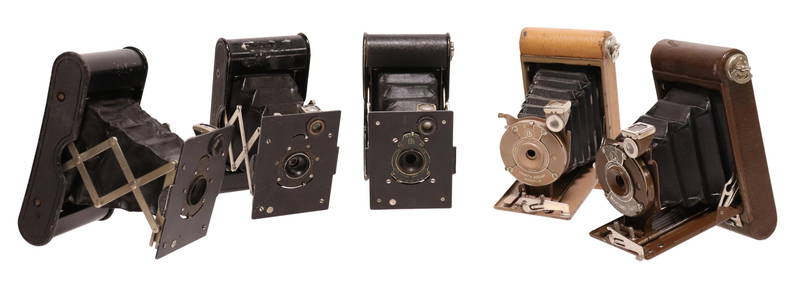
(5) EARLY KODAK VEST POCKET BELLOWS CAMERAS, BOOKAustin Auction Gallery4.7(1.2k)See Sold PriceApr 12, 2024


![Early Engraving Hand-Colored [Map, People] (1 of 3)](https://p1.liveauctioneers.com/5755/195519/98659024_1_x.jpg?height=282&quality=70&version=1614114976)


![[EARLY PHOTOGRAPHY]. Tintype of an African American couple in an outdoor setting. (1 of 2)](https://p1.liveauctioneers.com/197/319238/171467952_1_x.jpg?height=282&quality=70&version=1707520367)