1952 MAY, J.F.K. HANDWRITTEN LETTER & ENVELOPEJohn McInnis Auctioneers,LLC4.6(502)See Sold PriceFeb 25, 2024
WARNER BECKMAN'S TIGER MAPLE CELLO / SEABROOK NHJohn McInnis Auctioneers,LLC4.6(502)See Sold PriceFeb 25, 2024
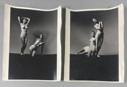
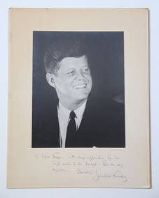
Victor Skrebneski Lingerie Fashion PhotographsEpic Auctions and Estate Sales4.6(204)See Sold PriceMar 02, 2024
[DOUGLASS, Frederick (1818-1895)]. ROBERTS, J.B., photographer. CDV of Frederick Douglass.Freeman's | Hindman4.4(1.6k)See Sold PriceFeb 27, 2024
1952 J.F.K. for SENATE TEAS & RECEPTION MATERIALJohn McInnis Auctioneers,LLC4.6(502)See Sold PriceFeb 25, 2024
HUGH D. AUCHINCLOSS' 70th BIRTHDAY with FAMILYJohn McInnis Auctioneers,LLC4.6(502)See Sold PriceFeb 25, 2024
CAROLINE KENNEDY at BAILEYS BEACH, NEWPORT, RIJohn McInnis Auctioneers,LLC4.6(502)See Sold PriceFeb 25, 2024
WILLIAM LINSMAN PHOTO SIGNED by JACKIE KENNEDYJohn McInnis Auctioneers,LLC4.6(502)See Sold PriceFeb 25, 2024
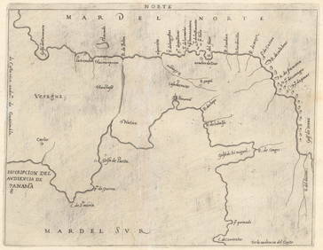
SoldAmerica Septentrio Map [Americas Map]America Septentrio Map, printed 20th-century, exact date unknown. Beautiful colors and detail. Measures 19.5-in. x 24.5-in. sheet size. In VG/EX condition. Unframed, loose and not glued or mounted. IfSee Sold Price
SoldSeptentrio America Restrike Engraving [Map]Septentrio map of the Americas restrike color engraving. From the original plate and created in the third quarter of the 20th century. Measures 14.375-in. x 19.5-in. image size, 19.625-in. x 24.375-inSee Sold Price
SoldAmerica Noviter Delineata Map [Americas Map]Jodicus Hondius (1563-1811), 'America Noviter Delineata Auct: Henrico Hondio, 1631' map. Exact date unknown; this restrike appears to be the right-side 2/3rds of original map. Beautiful colors and detSee Sold Price
Sold1783, History of America, MAP of Americas, 17771783, History of America, MAP of Americas, 1777 Strahan Cadell The History of America. By William Robertson, D.D., Principal of the University of Edinburgh, Historiographer to His Majesty for ScotlandSee Sold Price
Sold18th and 19th century maps Americas18th and 19th century maps, Americas: "America Divided Into North and South…", Lourie & Whittle, London, 1794, native tribes noted, 19-3/4 x 21-3/4 in. (sight), [separated at central fold]; "The WorSee Sold Price
Sold18th Century map of New World, insular California[Americas]. America. Engraved map of North and South America, early full hand-coloring, early 1700s? 6 1/4 x 7 1/2 in. Several locations on map labelled with abbreviations glossed in panels at right.See Sold Price
Reproduction of America Septentrio Nalis MapMap: Reproduction of 1639 Map "America Septentrio Nalis” Amstelodami Excudit Ioannes Ianbonius Size: 21 x 23 inches Please note that this lot has a reserve. When you leave a bid in advance of the auSee Sold Price
SoldAMERICA NOVA TABULA MAP OF THE AMERICASLarge Nova Tabula Map of the Americas. Vintage 20th century, depicting North and South America, bordered with ethnographic figures, after Guilielmo Blaeu. Professionally framed for Southern FurnitureSee Sold Price
SoldAmerica, Rare Early Map of the Americas"America", Rare Early Map of the Americas by Jodocus Hondius (Flemish/Dutch, 1563-1612) for a French edition of Mercator's Atlas, North and South America, hand-colored copper engraved map, published ASee Sold Price
Soldc.1740 Homann Heirs 4 Subject MapMapsLovely Colorful “Homann Heirs” Americas Map c. 1740, DOMINIA ANGLORUM IN AMERICA SEPTENTRIONAL DIE GROS-BRITANISCHE COLONIE-LAENDER IN NORD-AMERICA..., By Homann Heirs, Nuremberg, ChoiSee Sold Price
Soldc.1740 Homann Heirs 4 Subject MapMapsColorful Homann Heirs Four-Subject Americas Map c. 1740, DOMINIA ANGLORUM IN AMERICA SEPTENTRIONAL DIE GROS-BRITANISCHE COLONIE-LAENDER IN NORD-AMERICA..., By Homann Heirs, Nuremberg, Choice ExtreSee Sold Price
Thomson: Antique Map of North/South Americas, 1817TITLE/CONTENT OF MAP: 'America' A large detailed map of the Americas, printed in 1817. Florida is coloured yellow in common with British Canada and the Bahamas, indicating British territory which hadSee Sold Price
America. North/South Americas. British Florida.TITLE/CONTENT OF MAP: 'America' A large detailed map of the Americas, printed in 1817. Florida is coloured yellow in common with British Canada and the Bahamas, indicating British territory which hadSee Sold Price
America. North/South Americas. British Florida.TITLE/CONTENT OF MAP: 'America' A large detailed map of the Americas, printed in 1817. Florida is coloured yellow in common with British Canada and the Bahamas, indicating British territory which hadSee Sold Price
1863 Johnson's South America MapOne of America's best known map makers of the 19th Century, Johnson, showing territories that have changed over the last 150 years, Copyright 1863, Published by Johnson & Ward. Image size is 16 1/2" bSee Sold Price
SoldLarge Lot of Maps AmericasLarge group of maps including maps of the South Seas, North and South America, the Azore Islands, a province of Peru, Lima, Cayenne Island, Suriname, a world map, the cost of Peru, and Pisco. SKU: 034See Sold Price
Sold1779 French Engraved Framed Map Americas NR1779 French engraved framed map of North & Central America (probably printed about 100 years later) (Center fold with small, minor tears & holes; nice old appearance; frame much later; Old Print ShopSee Sold Price
SoldZaktieri Map of North America 1566ZALTIERI, Bolognino (fl. 1555-1575) after Paolo Forlani (fl.1560-71). [Americas Map] Il Disegno Del Discoperto Della Nova Franza, il quale s’e hauuto ultimamente dalla nouissima nauigatione de�See Sold Price
Soldc. 1717 North & South America Map as Discovered byHistoric Maps Impresive c. 1717 Map of the Americas by Nicolas de Fer with Title “ISLE DE CALIFORNIE” Prominently Shown c. 1717, Map of the Americas titled “Map of North and Middle America, baseSee Sold Price
Soldc. 1717 Americas Map as Discovered by ColumbusHistoric Maps Map of the Americas With “ISLE DE CALIFORNIE” c. 1717 Map of the Americas titled, “Map of North and Middle America, based on the observations of the members of the Academy of ScienSee Sold Price
c. 1717 Americas Map as Discovered by ColumbusHistoric Maps c. 1717 Map of the Americas "ISLE DE CALIFORNIE" c. 1717 Map of the Americas titled, "Map of North and Middle America, based on the observations of the members of the Academy of SciencesSee Sold Price
Soldc. 1717 North & South America Map as Discovered byHistoric Maps c. 1717 “ISLE DE CALIFORNIE” Map of the Americas c. 1717, Map of the Americas titled “Map of North and Middle America, based on the observations of the members of the Academy of ScSee Sold Price
Soldc. 1717 North & South America Map as Discovered byHistoric Maps c. 1717 Map of the Americas Title “ISLE DE CALIFORNIE” c. 1717, Map of the Americas titled “Map of North and Middle America, based on the observations of the members of the AcademySee Sold Price
Soldc. 1717 Americas Map as Discovered by ColumbusHistoric Maps c. 1717 Map of the Americas "ISLE DE CALIFORNIE" c. 1717 Map of the Americas titled, "Map of North and Middle America, based on the observations of the members of the Academy of SciencesSee Sold Price
1849 Mitchell School ATLAS 24 MAPS America Holy Land France Africa Egypt AsiaSchilb Antiquarian Rare Books4.8(421)See Sold PriceMar 31, 2024
Two (2) Antique 18th C. Copper Engraved Framed Maps - America & EuropeMagnusson Art Group4.5(46)See Sold PriceMar 14, 2024
Chatelain - Map of the Americas and Details and Insets of Government CounselsTrillium Antique Prints & Rare Books4.5(30)See Sold PriceFeb 24, 2024
Chatelain - 3 Maps of the British Isles (England, Ireland, Scotland)Trillium Antique Prints & Rare Books4.5(30)See Sold PriceFeb 24, 2024
Arrowsmith & Lewis - Map of North AmericaTrillium Antique Prints & Rare Books4.5(30)See Sold PriceFeb 24, 2024
Arrowsmith & Lewis - Map of the World on Mercator's ProjectionTrillium Antique Prints & Rare Books4.5(30)See Sold PriceFeb 24, 2024
Arrowsmith & Lewis - Map of LouisianaTrillium Antique Prints & Rare Books4.5(30)See Sold PriceFeb 24, 2024
Arrowsmith & Lewis - Map of the United StatesTrillium Antique Prints & Rare Books4.5(30)See Sold PriceFeb 24, 2024
Buffon, Vaugody & Bell 1785 America - Map of the New ContinentAlbion Auctions4.6(336)See Sold PriceMar 01, 2024
Herman Moll A New Map of Ye North Parts of AmericaWillow Auction House4.5(283)See Sold PriceMar 14, 2024


![America Septentrio Map [Americas Map] First Image](https://p1.liveauctioneers.com/5755/154409/77936931_1_x.jpg?height=282&quality=95&version=1573094011&width=282)
![America Septentrio Map [Americas Map] First Image](https://p1.liveauctioneers.com/5755/154409/77936931_1_x.jpg?height=282&quality=1&version=1573094011&width=282)

![[DOUGLASS, Frederick (1818-1895)]. ROBERTS, J.B., photographer. CDV of Frederick Douglass. (1 of 2)](https://p1.liveauctioneers.com/197/319238/171467829_1_x.jpg?height=282&quality=70&version=1707520367)


![America Septentrio Map [Americas Map] (1 of 3)](https://p1.liveauctioneers.com/5755/154409/77936931_1_x.jpg?height=282&quality=70&version=1573094011)
![Septentrio America Restrike Engraving [Map] (1 of 5)](https://p1.liveauctioneers.com/5755/161739/81664910_1_x.jpg?height=282&quality=70&version=1581557184)
![America Noviter Delineata Map [Americas Map] (1 of 3)](https://p1.liveauctioneers.com/5755/154409/77936930_1_x.jpg?height=282&quality=70&version=1573094011)