ATLAS of ANTIENT GEOGRAPHY by SAMUEL BUTLER 1843John McInnis Auctioneers,LLC4.6(502)See Sold PriceFeb 24, 2024
18TH C. ANTIQUE MAP: FRENCH & INDIAN WAR, FRAMEDThomaston Place Auction Galleries4.4(386)See Sold PriceFeb 24, 2024
Rand McNally Railroad Map Cabinet w/ 21 Railroad MapsRail & Road Auctions4.6(165)See Sold PriceMar 08, 2024
Keith Haring - Ink on New York Map, Best Buddies, Inscribed, Signed, and DatedSapphire Auction Gallery4(67)See Sold PriceMar 02, 2024
LATE 17TH C. FRENCH MAP OF THE NEW WORLD BY ALEXIS-HUBERT JAILLOT (1632-1712)Thomaston Place Auction Galleries4.4(386)See Sold PriceFeb 24, 2024
Central Railroad of New Jersey Map of Sandy Hook Route-ca. 1903JM Hobby Supply and Railroad Artifact Auctions4.4(126)See Sold PriceFeb 24, 2024
Lot of Six Mixed Atlas Box Cars-HO Scale-New in BoxJM Hobby Supply and Railroad Artifact Auctions4.4(126)See Sold PriceFeb 25, 2024
Rand McNally/Santa Fe Railroad Map of Iowa-1912JM Hobby Supply and Railroad Artifact Auctions4.4(126)See Sold PriceFeb 24, 2024
NICOLAES VISSCHER (NETHERLANDS, 1618-1709) MAP OF THE NEW WORLDThomaston Place Auction Galleries4.4(386)See Sold PriceFeb 24, 2024
17TH C. WORLD MAP BY NICOLAES VISSCHER (NETHERLANDS, 1618-1709)Thomaston Place Auction Galleries4.4(386)See Sold PriceFeb 24, 2024
Lot of Six Mixed Atlas Cabooses-HO Scale-New in BoxJM Hobby Supply and Railroad Artifact Auctions4.4(126)See Sold PriceFeb 25, 2024
Soldc. 1717 Americas Map as Discovered by ColumbusHistoric Maps Map of the Americas With “ISLE DE CALIFORNIE” c. 1717 Map of the Americas titled, “Map of North and Middle America, based on the observations of the members of the Academy of ScienSee Sold Price
c. 1717 Americas Map as Discovered by ColumbusHistoric Maps c. 1717 Map of the Americas "ISLE DE CALIFORNIE" c. 1717 Map of the Americas titled, "Map of North and Middle America, based on the observations of the members of the Academy of SciencesSee Sold Price
Soldc. 1717 Americas Map as Discovered by ColumbusHistoric Maps c. 1717 Map of the Americas "ISLE DE CALIFORNIE" c. 1717 Map of the Americas titled, "Map of North and Middle America, based on the observations of the members of the Academy of SciencesSee Sold Price
c. 1717 Americas Map as Discovered by ColumbusHistoric Maps c. 1717 Map of the Americas "ISLE DE CALIFORNIE" c. 1717 Map of the Americas titled, "Map of North and Middle America, based on the observations of the members of the Academy of SciencesSee Sold Price
c. 1717 Americas Map as Discovered by ColumbusHistoric Maps c. 1717 Map of the Americas "ISLE DE CALIFORNIE" c. 1717 Map of the Americas titled, "Map of North and Middle America, based on the observations of the members of the Academy of SciencesSee Sold Price
Soldc. 1717 North & South America Map as Discovered byHistoric Maps c. 1717 “ISLE DE CALIFORNIE” Map of the Americas c. 1717, Map of the Americas titled “Map of North and Middle America, based on the observations of the members of the Academy of ScSee Sold Price
Soldc. 1717 North & South America Map as Discovered byHistoric Maps Impresive c. 1717 Map of the Americas by Nicolas de Fer with Title “ISLE DE CALIFORNIE” Prominently Shown c. 1717, Map of the Americas titled “Map of North and Middle America, baseSee Sold Price
Soldc. 1717 North & South America Map as Discovered byHistoric Maps c. 1717 Map of the Americas Title “ISLE DE CALIFORNIE” c. 1717, Map of the Americas titled “Map of North and Middle America, based on the observations of the members of the AcademySee Sold Price
Soldc. 1706 Map of North & South America - ColumbusHistoric Maps c. 1706 Map of North & South America Discovered by Columbus c. 1706-1708, Original Map of North & South America, titled “America or the New World, first discovered and sailed by C. ColSee Sold Price
Soldc. 1706 Map of North & South America - ColumbusHistoric Maps c. 1706 Map of North & South America Discovered by Columbus c. 1706-1708, Original Map of North & South America, titled “America or the New World, first discovered and sailed by C. ColSee Sold Price
Soldc. 1706 Map of North & South America - ColumbusHistoric Maps c. 1706 Map of North & South America as Discovered & Sailed by Columbus by Dutch Map artist Pieter van der Aa c. 1706-1708, Original Map of North & South America, titled “America or thSee Sold Price
Sold(Maps and Charts, Americas), Lotter, Tobias Conrad(Maps and Charts, Americas), Lotter, Tobias Conrad (1717-1777), Recens Edita totius Novi Belgii..., Augsburg, [c.1760], with hand-coloring, double-page folio, unframed, 25 5/8 x 21 3/4 in., (repairedSee Sold Price
Soldc.1740 Homann Heirs 4 Subject MapMapsLovely Colorful “Homann Heirs” Americas Map c. 1740, DOMINIA ANGLORUM IN AMERICA SEPTENTRIONAL DIE GROS-BRITANISCHE COLONIE-LAENDER IN NORD-AMERICA..., By Homann Heirs, Nuremberg, ChoiSee Sold Price
Soldc.1740 Homann Heirs 4 Subject MapMapsColorful Homann Heirs Four-Subject Americas Map c. 1740, DOMINIA ANGLORUM IN AMERICA SEPTENTRIONAL DIE GROS-BRITANISCHE COLONIE-LAENDER IN NORD-AMERICA..., By Homann Heirs, Nuremberg, Choice ExtreSee Sold Price
Sold17TH C. MAP OF AMERICAS NICOLAUM VISSCHER(1618-1679):17th century map of Americas by Nicolaum Visscher. Also known as: Nicolaes Visscher Among the many great Dutch map publishers active in the seventeenth century were the Visscher family, begun by ClaesSee Sold Price
SoldSeuters Large Map of the Americas, c. 1730MapsSeutter’s Large Map of the Americas with California as an Island c. 1730, NOVUS ORBIS SIVE AMERICA MERIDOIONALIS ET SEPTENTRIONALIS...”, by Matthew Seutter, Augsburg, Very Fine. 19.5&rSee Sold Price
SoldSeuters Large Map of the Americas, c. 1730MapsSeutter’s Large Map of the Americas with California as an Island c. 1730, NOVUS ORBIS SIVE AMERICA MERIDOIONALIS ET SEPTENTRIONALIS...”, by Matthew Seutter, Augsburg, Very Fine. 19.5&rSee Sold Price
Soldc. 1730 Seuters Large Map of the AmericasMapsSeutter’s Large Map of the Americas c. 1730, NOVUS ORBIS SIVE AMERICA MERIDOIONALIS ET SEPTENTRIONALIS...”, by Matthew Seutter, Augsburg, Very Fine. 19.5” x 22.75” matted,See Sold Price
SoldSeuterÕs Large Map of the AmericasMapsSeutter’s Large Map of the Americas c. 1730, NOVUS ORBIS SIVE AMERICA MERIDOIONALIS ET SEPTENTRIONALIS...”, by Matthew Seutter, Augsburg, Very Fine. 19.5” x 22.75” matted,See Sold Price
Soldc. 1730 Seuters Large Map of the AmericasMapsSeutter’s Large Map of the Americas c. 1730, NOVUS ORBIS SIVE AMERICA MERIDOIONALIS ET SEPTENTRIONALIS...”, by Matthew Seutter, Augsburg, Very Fine. 19.5” x 22.75” matted,See Sold Price
SoldArend Fokke 18th-Early 19th c Dutch Map of AmericasAmsterdam writer & artist who was the son of the engraver Simon Fokke who illustrated the first Dutch edition of Perrault's "Contes de ma mère l'Oye" with 8 engraved plates, in 1754.Framed. North anSee Sold Price
SoldLarge Map of the Americas by Homann, c. 1720MapsLarge Map of the Americas by Homann c. 1720, German Cartographer's Map of North and South America, Very Fine. 20.25" x 24" hand-colored map with two large uncolored pictorial cartouches.See Sold Price
SoldLarge Map of the Americas by Homann, c. 1720MapsLarge Map of the Americas by Homann c. 1720, German Cartographer’s Map of North and South America, Very Fine. 20.25” x 24” hand-colored map with two large uncolored pictorial carSee Sold Price
Soldc. 1720, French Map of AmericasMapsc. 1720, AMERIQUE SEPTENTRIONALE, Choice Very Fine. 8.25” x 12.5”, uncolored. From a French atlas, showing North America to the Bay of Baffin, Central America, and the upper part of SSee Sold Price
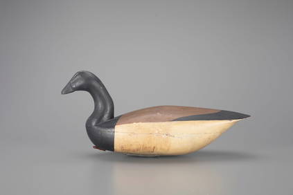
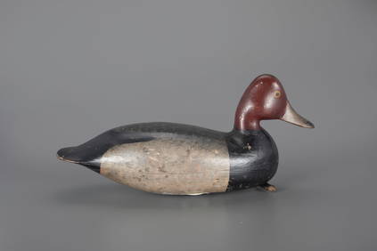
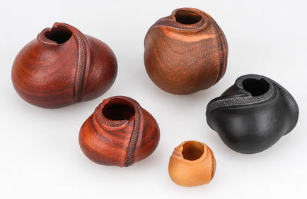
Rare Brant Decoy by Henry Kilpatrick (1867-1945)Copley Fine Art Auctions4.5(40)See Sold PriceFeb 24, 2024
JEB Rig Redhead Drake Decoy by Harry V. Shourds (1861-1920)Copley Fine Art Auctions4.5(40)See Sold PriceFeb 24, 2024
LARGE LATE 17TH C. DUTCH CHART OF CANADA, GREAT LAKES, NEW FRANCE, LABRADOR, HUDSON BAY, BY PIERREThomaston Place Auction Galleries4.4(386)See Sold PriceFeb 24, 2024
17TH C. WORLD MAP BY NICOLAES VISSCHER (NETHERLANDS, 1618-1709)Thomaston Place Auction Galleries4.4(386)See Sold PriceFeb 24, 2024
LATE 17TH C. FRENCH MAP OF THE NEW WORLD BY ALEXIS-HUBERT JAILLOT (1632-1712)Thomaston Place Auction Galleries4.4(386)See Sold PriceFeb 24, 2024
18TH C. ANTIQUE MAP: FRENCH & INDIAN WAR, FRAMEDThomaston Place Auction Galleries4.4(386)See Sold PriceFeb 24, 2024
PAIR (18th c) OF FLINTLOCK DUELING PISTOLSJohn McInnis Auctioneers,LLC4.6(502)See Sold PriceFeb 24, 2024
AMERICAN SCHOOL (Early 20th c) Two WorksJohn McInnis Auctioneers,LLC4.6(502)See Sold PriceFeb 25, 2024
Set of Two (2) Lounge Chairs by Warren Platner for Knoll in Original Red Knoll Fabric c. 1966Bidhaus4.3(747)See Sold PriceFeb 24, 2024
Michael K. Lee (Hawaiian, b.1960) 5 Sculptural BowlsMaterial Culture4.6(765)See Sold PriceFeb 29, 2024
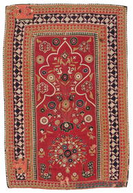
Resht Prayer Niche Embroidery, Persia, Mid 19th C., 3'4'' x 5'2''Material Culture4.6(765)See Sold PriceFeb 29, 2024
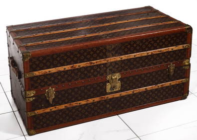
A FINE LARGE LOUIS VUITTON TRAVELING WARDROBE C. 1920sSoulis Auctions4.8(953)See Sold PriceFeb 24, 2024
A FINE PERSIAN MALAYER PRAYER RUG WITH CYPRESS C. 1860Soulis Auctions4.8(953)See Sold PriceFeb 24, 2024
19TH C GERMAN OIL PAINTING BY EMIL ZSCHIMMER C 1872Antique Arena Inc.4.5(852)See Sold PriceFeb 24, 2024
Willem Blaeu, Etc. 17th C. Antiquarian Maps, 2Auctions at Showplace4.5(726)See Sold PriceMar 17, 2024
Period 18Th C. Queen Anne Bonnet Top Tiger Maple HighboyRalph Fontaine Heritage Auctions Inc.4.7(235)See Sold PriceFeb 25, 2024
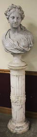
Magnificent 19Th C. Hand Carved Marble Bust And PedestalRalph Fontaine Heritage Auctions Inc.4.7(235)See Sold PriceFeb 25, 2024
Donovan's The Natural History of British Shells - 5 Volumes in 3 Books with 180 EngravingsTrillium Antique Prints & Rare Books4.5(30)See Sold PriceFeb 24, 2024
Rare Mid-Century Modern Egyptian Revival Ebonized "Thebes" Stool by Liberty & Company UnitedBidhaus4.3(747)See Sold PriceFeb 26, 2024
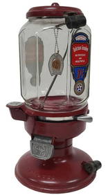
Restored Columbus Penny Glass Gumball Machine 1 C.Legacy Auctions & Estate Sales4.6(70)See Sold PriceFeb 25, 2024