ATLAS of ANTIENT GEOGRAPHY by SAMUEL BUTLER 1843John McInnis Auctioneers,LLC4.6(502)See Sold PriceFeb 24, 2024
18TH C. ANTIQUE MAP: FRENCH & INDIAN WAR, FRAMEDThomaston Place Auction Galleries4.4(386)See Sold PriceFeb 24, 2024
Rand McNally Railroad Map Cabinet w/ 21 Railroad MapsRail & Road Auctions4.6(165)See Sold PriceMar 08, 2024
Keith Haring - Ink on New York Map, Best Buddies, Inscribed, Signed, and DatedSapphire Auction Gallery4(67)See Sold PriceMar 02, 2024
LATE 17TH C. FRENCH MAP OF THE NEW WORLD BY ALEXIS-HUBERT JAILLOT (1632-1712)Thomaston Place Auction Galleries4.4(386)See Sold PriceFeb 24, 2024
Central Railroad of New Jersey Map of Sandy Hook Route-ca. 1903JM Hobby Supply and Railroad Artifact Auctions4.4(126)See Sold PriceFeb 24, 2024
Lot of Six Mixed Atlas Box Cars-HO Scale-New in BoxJM Hobby Supply and Railroad Artifact Auctions4.4(126)See Sold PriceFeb 25, 2024
Rand McNally/Santa Fe Railroad Map of Iowa-1912JM Hobby Supply and Railroad Artifact Auctions4.4(126)See Sold PriceFeb 24, 2024
NICOLAES VISSCHER (NETHERLANDS, 1618-1709) MAP OF THE NEW WORLDThomaston Place Auction Galleries4.4(386)See Sold PriceFeb 24, 2024
17TH C. WORLD MAP BY NICOLAES VISSCHER (NETHERLANDS, 1618-1709)Thomaston Place Auction Galleries4.4(386)See Sold PriceFeb 24, 2024
Lot of Six Mixed Atlas Cabooses-HO Scale-New in BoxJM Hobby Supply and Railroad Artifact Auctions4.4(126)See Sold PriceFeb 25, 2024
MAP - Sardinia. Le RougeSardinia. Le Rouge, Le Royaume de Sardaigne Dresse sur les Cartes Manuscrites Levees dans le Pays par les Ingenieurs Piemontois, 1753 (dated). Hand Color. This handsome map of Sardinia provides excellSee Sold Price
MAP - Sardinia. Le RougeSardinia. Le Rouge, Le Royaume de Sardaigne Dresse sur les Cartes Manuscrites Levees dans le Pays par les Ingenieurs Piemontois, 1753 (dated). Hand Color. This handsome map of Sardinia provides excellSee Sold Price
Sold1753 Map of SardiniaHand-colored 1753 map of Sardinia. George Louis Le Rouge. Framed under glass. Image: 28-1/2" x 17".See Sold Price
SoldLe Royaume de Sardaigne'. Sardegna. Kingdom of Sardinia. LE ROUGE 1753 mapTitle: Le Royaume de Sardaigne'. Sardegna. Kingdom of Sardinia. LE ROUGE 1753 map Description: Le Royaume de Sardaigne [The Kingdom of Sardinia]' by George Louis Le Rouge (1753 (This date is printed oSee Sold Price
Soldle Rouge: Highly detailed 1753 Kingdom of Sardinia MapMap Title: Le Royaume de Sardaigne Cartographer: le Rouge Place / Date: Paris / 1753 Size: 16 1/2" x 28 1/2" Condition: outline color; spotting mostly (but not entirely) confined to margins and lowerSee Sold Price
Le Rouge: Antique Map of Kingdom of Sardinia 1753The fortified towns of Sassari, Alghero, Cagliari, Terra Nova (Olbia), Ampurias (Castelsardo) and Carloforte on Isola di San Pietro are marked DATE PRINTED: 1753 (This date is printed on the map) IMAGSee Sold Price
le Rouge: The Kingdom of Sardinia, 1753Le Royaume de Sardaigne Le Rouge's large, splendidly detailed map of the Kingdom of Sardinia ("based on the manuscript maps drawn on the island by Piedmontese engineers") includes a brief historical sSee Sold Price
le Rouge: The Kingdom of SardiniaMap Title: Le Royaume de Sardaigne Cartographer: le Rouge Place/Date: Paris / 1753 Size: 16 1/2" x 28 1/2" Conditon: outline color; spotting mostly (but not entirely) confined to margins and lower lefSee Sold Price
le Rouge: The Kingdom of SardiniaReserve Reduced! Map Title: Le Royaume de Sardaigne Cartographer: le Rouge Place / Date: Paris / 1753 Size: 16 1/2" x 28 1/2" Condition: outline color; spotting mostly (but not entirely) confined to mSee Sold Price
le Rouge: The Kingdom of SardiniaCartographer: le Rouge Place/Date: Paris / 1753 Size: 16 1/2" x 28 1/2" Condition: outline color; spotting mostly (but not entirely) confined to margins and lower left corner; some wrinkling at centerSee Sold Price
SoldLes Bermudes. Map. Le Rouge, 1779.[Bermuda]. Les Bermudes Levees par Lempriere Determinees Astronomiquement a Londres en 1775. Traduit de l’Anglois.. Paris: Le Rouge, 1779. 17 ½” x 24 ¼”. Watermarked laid paper. Occasional nicSee Sold Price
Map, Homann, Le Rouge, Westphalia, Mayence(lot of 2) Unframed handcolored engraved map, ''La Westphalie Suivant les dernieres observations de Homann et de Hubener,'' 1742, by Georges Louis Le Rouge (French, c.1712-c.1790) after maps by HomannSee Sold Price
Map, Homann, Le Rouge, Westphalia, Mayence(lot of 2) Unframed handcolored engraved map, ''La Westphalie Suivant les dernieres observations de Homann et de Hubener,'' 1742, by Georges Louis Le Rouge (French, c.1712-c.1790) after maps by HomannSee Sold Price
Map, Homann, Le Rouge, Westphalia, Mayence(lot of 2) Unframed handcolored engraved map, ''La Westphalie Suivant les dernieres observations de Homann et de Hubener,'' 1742, by Georges Louis Le Rouge (French, c.1712-c.1790) after maps by HomannSee Sold Price
SoldMaps, Jaillot, le Rouge, Germany, Spain(lot of 5) Unframed handcolored engraved maps: ''Eveche d'Osnabruc,'' 1757, published by le Rouge, plate: 20.375''h x 16.875''w, sheet: 28.5''h x 21.125''w; ''Galicia, Asturias, Leon, Castilla la ViejSee Sold Price
Maps, Jaillot, le Rouge, Germany, Spain(lot of 5) Unframed handcolored engraved maps: ''Eveche d'Osnabruc,'' 1757, published by le Rouge, plate: 20.375''h x 16.875''w, sheet: 28.5''h x 21.125''w; ''Galicia, Asturias, Leon, Castilla la ViejSee Sold Price
Sold1743 Le Rouge Map of Southern Poland and parts of CzechTitle/Content of Map: 1743 Le Rouge Map of Southern Poland and parts of Czech Republic (Silesia) -- Le Duche De Silesie divse en XVII Principautees . . . Date: 1743, Paris Cartographer: G Le Rouge SizSee Sold Price
Sold1743 Le Rouge Map of Southern Czech Republic (Moravia)Title/Content of Map: 1743 Le Rouge Map of Southern Czech Republic (Moravia) -- Le Marquisat de Moravie par et Chez le St. le Rouge ingenieur Geogrephe du Roy Rue des Augustins a Paris 1743 Date: 1743See Sold Price
Sold1743 Le Rouge Map of the German Empire -- L'EmpireTitle/Content of Map: 1743 Le Rouge Map of the German Empire -- L'Empire d'Allemagne de die a Monseigneur a Melot ministre a Secretaire d'Etal par le Rouge a Paris... Date: 1743, Paris Cartographer: GSee Sold Price
1743 Le Rouge Map of Southern Czech Republic (Moravia)Reserve Reduced! Title/Content of Map: 1743 Le Rouge Map of Southern Czech Republic (Moravia) -- Le Marquisat de Moravie par et Chez le St. le Rouge ingenieur Geogrephe du Roy Rue des Augustins a PariSee Sold Price
1748 Le Rouge Map of Southern Germany and NorthernReserve Reduced! Title/Content of Map: 1748 Le Rouge Map of Southern Germany and Northern Switzerland -- La Souabe Aparis par et Chez le St. le Rouge Geo. du Roy rue des Grands Augistins Date: 1748, PSee Sold Price
1743 Le Rouge Map of Southern Czech Republic (Moravia)Title/Content of Map: 1743 Le Rouge Map of Southern Czech Republic (Moravia) -- Le Marquisat de Moravie par et Chez le St. le Rouge ingenieur Geogrephe du Roy Rue des Augustins a Paris 1743 Date: 1743See Sold Price
1743 Le Rouge Map of Southern Poland and parts of CzechTitle/Content of Map: 1743 Le Rouge Map of Southern Poland and parts of Czech Republic (Silesia) -- Le Duche De Silesie divse en XVII Principautees . . . Date: 1743, Paris Cartographer: G Le Rouge SizSee Sold Price
1748 Le Rouge Map of Southern Germany and NorthernTitle/Content of Map: 1748 Le Rouge Map of Southern Germany and Northern Switzerland -- La Souabe Aparis par et Chez le St. le Rouge Geo. du Roy rue des Grands Augistins Date: 1748, Paris CartographerSee Sold Price
Simona Candini original acrylic on masonite, titled "Le Moulin Rouge - three fates", low brow, popNeely Auction4.6(224)See Sold PriceFeb 25, 2024
Jean Gilles (In the Style of Louis Icart) - Le Manteau RougeDane Fine Art Auctions4.4(494)See Sold PriceMar 21, 2024
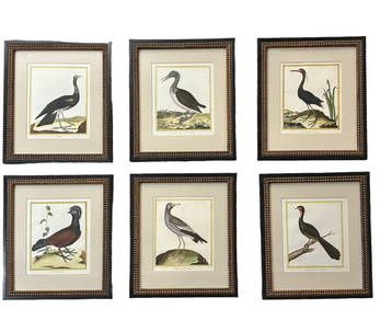
6 Francois Martinet Engravings of BirdsBroken Arch Auction Gallery NCFL#93994.6(294)See Sold PriceMar 04, 2024
NORTH & WEST AFRICA. Sahara Niger river 'Zaara ou le Desert'. MALLET 1683 mapJasper524.5(9.8k)See Sold PriceFeb 28, 2024
Coste Occidentale d’Afrique…' Arguin Bay Cap Blanc Mauritania. BELLIN 1746 mapJasper524.5(9.8k)See Sold PriceFeb 28, 2024
Coste Occidentale d’Afrique'. Bay of Arguin, Mauritania. BELLIN/SCHLEY 1747 mapJasper524.5(9.8k)See Sold PriceFeb 28, 2024
Le Canal de Mosambique, l'Isle de Madagascar… Mozambique. Africa. BONNE 1788 mapJasper524.5(9.8k)See Sold PriceFeb 28, 2024
Le Royaume d’Adel… Ajan & Zanguebar. Adal Ajuran. Kenya Tanzania. BONNE 1788 mapJasper524.5(9.8k)See Sold PriceFeb 28, 2024
Coste d’Afrique…' Guinea-Bissau & Bissagos archipelago. BELLIN 1746 old mapJasper524.5(9.8k)See Sold PriceFeb 28, 2024
Le Canal de Mosambique, l'Isle de Madagascar… Mozambique. Africa. BONNE 1790 mapJasper524.5(9.8k)See Sold PriceFeb 28, 2024
Le Royaume d’Adel… Ajan & Zanguebar. Adal Ajuran. Kenya Tanzania. BONNE 1790 mapJasper524.5(9.8k)See Sold PriceFeb 28, 2024
Carte du Golfe de Guinée. Gulf of Guinea Nigeria Cameroon BELLIN/SCHLEY 1748 mapJasper524.5(9.8k)See Sold PriceFeb 28, 2024
Coste d’Afrique…' Guinea-Bissau & Bissagos archipelago. BELLIN/SCHLEY 1747 mapJasper524.5(9.8k)See Sold PriceFeb 28, 2024
Cooke, George 1801 Antique Map. Italy, Sicily, Sardinia & CorsicaAlbion Auctions4.6(336)See Sold PriceMar 01, 2024
Framed Vintage Map Of Le Port Au Prince In The Island Of Santo DomingoRapid Estate Liquidators and Auction Gallery4.5(1.1k)See Sold PriceMar 01, 2024