160farbige Maps and plans160farbige Landkarten und Stadtpläne aus Meyers Konversationslexikon, 6. Auflage, verlegt vom Bibliographischen Institut Leipzig, altersgemäß guter Zustand, ca. 18,5 x 23,5 cm (HxB); BiSee Sold Price
SoldMawman: Antique Map Plan of Athens, Greece, 1791Original copper engraving from the 1791 "Maps, Plans, Views, and Coins Illustrative of the Travels of Anacharsis the Younger in Greece". by J. Mawman, 1805. Plan of the Academy & Environs for the travSee Sold Price
SoldMawman: Antique Map Plan of Athens, Greece, 1791Original copper engraving from the 1791 "Maps, Plans, Views, and Coins Illustrative of the Travels of Anacharsis the Younger in Greece". by J. Mawman, 1805. Plan of the Athens for the travels of AnachSee Sold Price
SoldStedman's American Revolution, 1794, with maps & plansHeading: Author: Stedman, Charles Title: The History of the Origin, Progress, and Termination of the American War Author: Stedman, Charles Place: London Publisher: Printed fSee Sold Price
SoldA History of Rome with Maps, Plans, Engravings 1883"A History of Rome. Amply Illustrated with Maps, Plans, and Engravings", by R. F. Leighton, published by Clark amd Mynard, New York, 1883, copyright 1878. US: Priority (c 2-4 days) -------- $8.50 CanaSee Sold Price
SoldMaps, Plans, Views and Coins Travels of Anacharsis theMaps, Plans, Views and Coins Illustrative of the Travels of Anacharsis the Younger in Greece, during the middle of the fourth century before the christian aera. Vol VIII, Second Edition. Published LonSee Sold Price
Sold1854 U.S. Reports volume w/ 45 maps & plansHeading: (U.S. Government - General Land Office) Author: Title: Message from the President of the United States to the Two Houses of Congress, At the Commencement of the Second Session of the Thirty-See Sold Price
SoldA HISTORY OF ROME WITH MAPS, PLANS, ENGRAVINGS BY RFA HISTORY OF ROME WITH MAPS, PLANS, ENGRAVINGS BY RF LEIGHTON 1887See Sold Price
SoldMawman: Antique Map Plan of Athens, Greece, 1791Original copper engraving from the 1791 "Maps, Plans, Views, and Coins Illustrative of the Travels of Anacharsis the Younger in Greece". by J. Mawman, 1805. Plan of the Athens for the travels of AnachSee Sold Price
SoldWyld (James) Maps & PlansWyld (James) Maps & Plans, Showing the Principal Movements, Battles & Sieges, in which the British Army was engaged during the War from 1808 to 1814 in the Spanish Peninsula and the South of France,See Sold Price
A History of Rome with Maps, Plans, Engravings 1883"A History of Rome. Amply Illustrated with Maps, Plans, and Engravings", by R. F. Leighton, published by Clark amd Mynard, New York, 1883, copyright 1878. Please let us know if you prefer the faster sSee Sold Price
Sold[Greece/Turkey]. Approx. 50 Maps, Plans, and Engr[Greece/Turkey]. Approx. 50 Maps, Plans, and Engravings. Size varies 9 x 13 to 6 x 4 inches. Half in Greek, many in outline color. Condition varies, should be seen. This is a live auction at our physiSee Sold Price
Sold3 pieces. Engraved Maps & Plans - Egypt: [Mercato3 pieces. Engraved Maps & Plans - Egypt: [Mercator/Hondius/Jansson Atlas?] Africae, Egyptum Inferiorem Exhibens." Ca. 1730. Partly hand-colored engraving. 9 3/4 x 14 1/2 inches (247 x 368 mm), wide maSee Sold Price
Sold[Staunton (Sir George)] Maps, Plans[Staunton (Sir George)] A small group of maps, plans, and plates from An Authentic Account of an Embassy from the King of Great Britain to the Emperor of China,including Plans, ...of the GreatSee Sold Price
SoldRoux's Mediterranean Atlas w/121 maps plans 1761Title: Recueil des principaux plans des ports et rades de la Mer Mediterranee... Author: Roux, Joseph Description: With engraved title & 120 (of 121) copper-engraved charts & plans; + 11 additional maSee Sold Price
SoldWyld, James, publisher Maps & Plans Showing theLondon, [n.d.] Elephant folio, 37 engraved maps and plans, original red half morocco gilt over green cloth, some foxing and occasional light dampstaining; Belmas, J. Journaux des Siéges faits ouSee Sold Price
SoldMaps & plans, showing the principal movements, battles(James, editor ) Maps & plans, showing the principal movements, battles & Sieges, in which the British army was engaged during the war from 1808 to 1814… , 57 engraved or lithographed plans andSee Sold Price
SoldMaps & plans of Tuscany Rome and NaplesRobert de Vaugondy (Gilles & Didier) Carte du Grand-Duch‚ de Toscane,Tuscany from Genoa to the Isle of Elba, large decorative title cartouche lower left, engraved map by P. Santini, with origiSee Sold Price
SoldCol Cooper’s personal files, installation maps, plans +This lot is to include a large amount of paperwork and files such as USAF major installations maps, personal hand written notes, resume, perform and configurations, phone numbers, air war college studSee Sold Price
Sold-. large mixed group of maps, plans, and topograp-. large mixed group of maps, plans, and topographical views (A)including maps of Europe, Asia Minor, and with plans of Venice and Rome, an elevation of the facade of the Orangery at VersaillSee Sold Price
SoldU.S. Senate documents with maps & plansHeading: Author: U.S. Senate Title: Two volumes of Maps & Views to Accompany Message from the President of the United States to the Two Houses of Congress... 1855-6 & 1856-7 Place Published: WashingtSee Sold Price
Sold(James, editor) Maps & plans, showing the principaWyld (James, editor) Maps & plans, showing the principal movements, battles & Sieges, in which the British army was engaged during the war from 1808 to 1814..., 39 double-page lithographed mapSee Sold Price
17thc Copper Engraving Map, Plan of Canterbury City1661 copper engraving, black and white as issued, blank verso. Plan of Cantuaria, Canterbury, Kent, from Rutger Hermannides’ Magna Britannia. Nearly all of the plans are based on the small inseSee Sold Price
1887 Appletons' General Guide to the United State and Canada Part IIRail & Road Auctions4.6(165)See Sold PriceMar 08, 2024
1711 GREEK BIBLE ILLUSTRATED w/ MAPS VELLUM BOUND antique NEW TESTAMENTJasper524.5(9.8k)See Sold PriceFeb 27, 2024
THE MATRIX RELOADED (2003)/THE MATRIX REVOLUTIONS (2003) - VFX Freeway Diagram PortfolioPropstore4.2(6)See Sold PriceMar 14, 2024
1730 BIBLE in DUTCH ILLUSTRATED w/ MAPS antique MASSIVE FOLIO BIBLIAJasper524.5(9.8k)See Sold PriceFeb 27, 2024
West Africa by Arrowsmith & Lewis 1812 old antique vintage map plan chartJasper524.5(9.8k)See Sold PriceFeb 28, 2024
AFRICA. Pre 'Scramble for Africa'. BARTHOLOMEW 1876 old antique map plan chartJasper524.5(9.8k)See Sold PriceFeb 28, 2024
Carte d'Afrique. Africa Soudan Zanzibar. LAPIE 1831 old antique map plan chartJasper524.5(9.8k)See Sold PriceFeb 28, 2024
Western Sahara. Africa 1885 old antique vintage map plan chartJasper524.5(9.8k)See Sold PriceFeb 28, 2024
AFRICA. Africa. Britannica 9th edition 1898 old antique vintage map plan chartJasper524.5(9.8k)See Sold PriceFeb 28, 2024
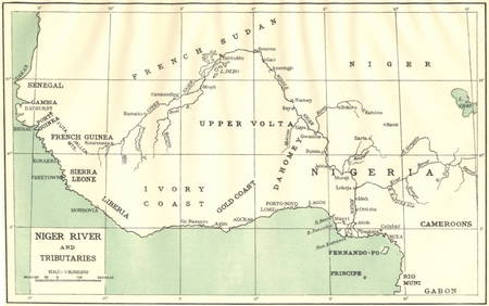
AFRICA. Niger River and Tributaries 1936 old vintage map plan chartJasper524.5(9.8k)See Sold PriceFeb 28, 2024
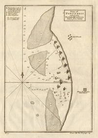
Plan of Portendic… Portu d'Addi or Penia. Portendick Mauritania. LABAT 1745 mapJasper524.5(9.8k)See Sold PriceFeb 28, 2024
AFRICA. French North Africa and Morocco 1907 old antique map plan chartJasper524.5(9.8k)See Sold PriceFeb 28, 2024
Showers of Red Dust. Africa. Sahara 1886 old antique vintage map plan chartJasper524.5(9.8k)See Sold PriceFeb 28, 2024
Africa by Arrowsmith & Lewis 1812 old antique vintage map plan chartJasper524.5(9.8k)See Sold PriceFeb 28, 2024
Barthelemy, Jean 1790 Map. Greece - Plan de L'AcademieAlbion Auctions4.6(336)See Sold PriceMar 01, 2024
Poster "Les jardins de Paris", illustrated map and plan of Paris with its parcs, gardens, monuments,Proverde Auctions4.3(3)See Sold PriceFeb 28, 2024
[Constructivism]. The general plan of reconstruction of Moscow. - Moscow: Moscow Worker, 1936. -ARTMAXIMUM4.3(4)See Sold PriceMar 14, 2024


![[Greece/Turkey]. Approx. 50 Maps, Plans, and Engr (1 of 0)](https://p1.liveauctioneers.com/dist/images/placeholder.jpg?height=282&quality=70)


![[Constructivism]. The general plan of reconstruction of Moscow. - Moscow: Moscow Worker, 1936. - (1 of 6)](https://p1.liveauctioneers.com/6171/320219/172084257_1_x.jpg?height=282&quality=70&version=1708525949)