ATLAS of ANTIENT GEOGRAPHY by SAMUEL BUTLER 1843John McInnis Auctioneers,LLC4.6(502)See Sold PriceFeb 24, 2024
18TH C. ANTIQUE MAP: FRENCH & INDIAN WAR, FRAMEDThomaston Place Auction Galleries4.4(386)See Sold PriceFeb 24, 2024
Rand McNally Railroad Map Cabinet w/ 21 Railroad MapsRail & Road Auctions4.6(165)See Sold PriceMar 08, 2024
Keith Haring - Ink on New York Map, Best Buddies, Inscribed, Signed, and DatedSapphire Auction Gallery4(67)See Sold PriceMar 02, 2024
LATE 17TH C. FRENCH MAP OF THE NEW WORLD BY ALEXIS-HUBERT JAILLOT (1632-1712)Thomaston Place Auction Galleries4.4(386)See Sold PriceFeb 24, 2024
Central Railroad of New Jersey Map of Sandy Hook Route-ca. 1903JM Hobby Supply and Railroad Artifact Auctions4.4(126)See Sold PriceFeb 24, 2024
Lot of Six Mixed Atlas Box Cars-HO Scale-New in BoxJM Hobby Supply and Railroad Artifact Auctions4.4(126)See Sold PriceFeb 25, 2024
Rand McNally/Santa Fe Railroad Map of Iowa-1912JM Hobby Supply and Railroad Artifact Auctions4.4(126)See Sold PriceFeb 24, 2024
NICOLAES VISSCHER (NETHERLANDS, 1618-1709) MAP OF THE NEW WORLDThomaston Place Auction Galleries4.4(386)See Sold PriceFeb 24, 2024
17TH C. WORLD MAP BY NICOLAES VISSCHER (NETHERLANDS, 1618-1709)Thomaston Place Auction Galleries4.4(386)See Sold PriceFeb 24, 2024
Lot of Six Mixed Atlas Cabooses-HO Scale-New in BoxJM Hobby Supply and Railroad Artifact Auctions4.4(126)See Sold PriceFeb 25, 2024
Sold1874 Mitchell Map of Kentucky and Tennessee -- CountyTitle/Content of Map: 1874 Mitchell Map of Kentucky and Tennessee -- County Map of Kentucky and Tennessee Date: 1874 Philadelphia Cartographer: S Mitchell Size: 10.5 x 13.4 in. A nice map of KentuckySee Sold Price
1874 Mitchell Map of Kentucky and Tennessee -- CountyTitle/Content of Map: 1874 Mitchell Map of Kentucky and Tennessee -- County Map of Kentucky and Tennessee Date: 1874 Philadelphia Cartographer: S Mitchell Size: 10.5 x 13.4 in. A nice map of KentuckySee Sold Price
1874 Mitchell Map of Kentucky and Tennessee -- CountyTitle: 1874 Mitchell Map of Kentucky and Tennessee -- County Map of Kentucky and Tennessee Date: 1874 Philadelphia Cartographer: S Mitchell Size: 10.5 x 13.4 in. Additional Information: A nice map ofSee Sold Price
1874 Mitchell Map of Kentucky and Tennessee -- CountyReserve Reduced! Title/Content of Map: 1874 Mitchell Map of Kentucky and Tennessee -- County Map of Kentucky and Tennessee Date: 1874 Philadelphia Cartographer: S Mitchell Size: 10.5 x 13.4 in. A niceSee Sold Price
1874 Mitchell Map of Kentucky and Tennessee -- CountyTitle/Content of Map: 1874 Mitchell Map of Kentucky and Tennessee -- County Map of Kentucky and Tennessee Date Printed: 1874 Philadelphia Cartographer: S Mitchell Size: 10.5 x 13.4 in. A nice map of KSee Sold Price
SoldMitchell: Antique Map of Kentucky and Tennessee, 1874Title/Content of Map: 1874 Mitchell Map of Kentucky and Tennessee -- County Map of Kentucky and Tennessee Date Printed: 1874 Philadelphia Cartographer: S Mitchell Size: 10.5 x 13.4 in. A nice map of KSee Sold Price
Antique 1874 Mitchell Map of Kentucky and TennesseeTitle/Content of Map: 1874 Mitchell Map of Kentucky and Tennessee -- County Map of Kentucky and Tennessee Date Printed: 1874 Philadelphia Cartographer: S Mitchell Size: 10.5 x 13.4 in. A nice map of KSee Sold Price
Mitchell: Antique Map of Kentucky and Tennessee, 1874Title/Content of Map: 1874 Mitchell Map of Kentucky and Tennessee -- County Map of Kentucky and Tennessee Date Printed: 1874 Philadelphia Cartographer: S Mitchell Size: 10.5 x 13.4 A nice map of KentuSee Sold Price
Sold1867 Mitchell Map of Kentucky and Tennessee -- CountyReserve Reduced! Title/Content of Map: 1867 Mitchell Map of Kentucky and Tennessee -- County Map of Kentucky and Tennessee Date: 1867 Philadelphia Cartographer: S Mitchell Size: 10.5 x 13.4 in. A niceSee Sold Price
1860 Mitchell Map of Kentucky and Tennessee -- County Map of Kentucky and TennesseeTitle: 1860 Mitchell Map of Kentucky and Tennessee -- County Map of Kentucky and Tennessee Cartographer: S Mitchell Year / Place: 1860, Philadelphia Map Dimension (in.): 10.6 X 13.3 in. This is an excSee Sold Price
1871 Mitchell Map of Kentucky and Tennessee -- CountyReserve Reduced! Title/Content of Map: 1871 Mitchell Map of Kentucky and Tennessee -- County Map of Kentucky and Tennessee Date: 1871 Philadelphia Cartographer: S Mitchell Size: 10.6 X 13.5 in. HandsoSee Sold Price
1871 Mitchell Map of Kentucky and Tennessee -- CountyTitle/Content of Map: 1871 Mitchell Map of Kentucky and Tennessee -- County Map of Kentucky and Tennessee Cartographer: S Mitchell Size: 10.6 X 13.5 in. Handsome county map of Kentucky and Tennessee wSee Sold Price
1867 Mitchell Map of Kentucky and Tennessee -- CountyTitle/Content of Map: 1867 Mitchell Map of Kentucky and Tennessee -- County Map of Kentucky and Tennessee Date Printed: 1867 Philadelphia Cartographer: S Mitchell Size: 10.5 x 13.4 in. A nice map of KSee Sold Price
1871 Mitchell Map of Kentucky and Tennessee -- CountyTitle/Content of Map: 1871 Mitchell Map of Kentucky and Tennessee -- County Map of Kentucky and Tennessee Date: 1871, Philadelphia Cartographer: S Mitchell Size: 10.5 X 13.5 in. Nicely detailed map shSee Sold Price
1871 Mitchell Map of Kentucky and Tennessee -- CountyTitle/Content of Map: 1871 Mitchell Map of Kentucky and Tennessee -- County Map of Kentucky and Tennessee Date: 1871 Philadelphia Cartographer: S Mitchell Size: 10.6 X 13.5 in. Handsome county map ofSee Sold Price
Mitchell: Antique Map of Kentucky & Tennessee, 1883Map: 1883 Mitchell Map of Kentucky and Tennessee -- County Map of Kentucky and Tennessee Date Printed: 1883, Philadelphia Cartographer: S Mitchell Size: 14.8 X 19 in. Condition: Excellent. Very nicelySee Sold Price
1871 Mitchell Antique Map of Kentucky and TennesseeTitle/Content of Map: 1871 Mitchell Map of Kentucky and Tennessee -- County Map of Kentucky and Tennessee Date Printed: 1871, Philadelphia Cartographer: S Mitchell Size: 10.5 X 13.5 in. Nicely detaileSee Sold Price
1871 Mitchell Antique Map of Kentucky and TennesseeTitle/Content of Map: 1871 Mitchell Map of Kentucky and Tennessee -- County Map of Kentucky and Tennessee Date Printed: 1871, Philadelphia Cartographer: S Mitchell Size: 10.5 X 13.5 Nicely detailed maSee Sold Price
SoldMitchell: County Map of Kentucky & Tennessee, 1870Title/Content of Map: County Map of Kentucky and Tennessee Cartographer: S. A. Mitchell Place & Date: Philadelphia / 1870 Size: 13 3/8" x 9 3/4" Condition: full color; light overall age toning; slightSee Sold Price
Sold1872 MITCHELL COUNTY MAP OF KENTUCKY AND TENNESSEEHand colored map by Samuel Augustus Mitchell measuring 13 by 10 inches. It is in very good condition with some minor foxing to border.See Sold Price
SoldCivil War Era County Map of Kentucky & Tennessee, 1860Civil War Era Hand Colored County Map of Kentucky & Tennessee | Map no. 28 from Mitchell's New General Atlas. Philadelphia: S. Augustus Mitchell, Jr., 1860 | Inscribed in the lower left margin: "EnterSee Sold Price
Samuel Augustus Mitchell (1790-1868), "County Map ofSamuel Augustus Mitchell (1790-1868), "County Map of Kentucky and Tennessee," 1866, H. - 12 1/4 in., W. - 15 1/4 in.See Sold Price
SoldCivil War Era County Map of Kentucky & Tennessee, 18601860 Hand-Colored Engraved Civil War Era County Map of Kentucky & Tennessee by Samuel Augustus Mitchell, Jr., Philadelphia, 1860, From Mitchell's Atlas, Plate 31, Steel engraved floral border | A detaSee Sold Price
Sold19TH CENTURY MITCHELL MAP OF SOUTHERN STATESTwo maps in lot , one 1860 County Map of Georgia and Alabama and the other is a 1867 County Map of Kentucky and Tennessee. Both are hand colored and in excellent condition with some foxing to the bordSee Sold Price
Hammonds Map of Kentucky and Tennessee Railroads-1910JM Hobby Supply and Railroad Artifact Auctions4.4(126)See Sold PriceFeb 24, 2024
Map UNITED COUNTIES LEEDS & GRENVILLE by Walling 1861 Rare Canada Map 5ft x 5ftLuis Porretta Fine Arts4.3(10)See Sold PriceMar 02, 2024
DUNLEVIE c1856 Map Counties Of Gaspe & Bonaventure Quebec Canada SCARCE! #2Luis Porretta Fine Arts4.3(10)See Sold PriceMar 02, 2024
DUNLEVIE c1856 Map Counties Of Gaspe & Bonaventure Quebec Canada SCARCE! #1Luis Porretta Fine Arts4.3(10)See Sold PriceMar 02, 2024
Early 1900's Railway Service Map, Illinois, Ohio, Indiana, Kentucky, TennesseeConnoisseur Auctions4(333)See Sold PriceFeb 24, 2024
Vintage County Map Of NY State Plate EngravingThe Benefit Shop Foundation Inc.4.3(2.9k)See Sold PriceFeb 28, 2024
Portfolio of 15 County Maps by Robert Morden (English 1650-1703)Nadeau's Auction Gallery4.7(401)See Sold PriceFeb 24, 2024
1849 Mitchell School ATLAS 24 MAPS America Holy Land France Africa Egypt AsiaSchilb Antiquarian Rare Books4.8(421)See Sold PriceMar 31, 2024
Pair of Early Railroad Maps - 1874 Delaware, Lackawanna & Western and 1876 Pennsylvania RailroadRail & Road Auctions4.6(165)See Sold PriceMar 07, 2024
5"Bi Pointed Knife. Sonora flint. Hardin County, Kentucky. Ex Dale RectorTony Putty Artifacts4.7(404)See Sold PriceMar 09, 2024
8 5/8" Dover Blade. Found by John Putrum in the 1950s.Tony Putty Artifacts4.7(404)See Sold PriceMar 09, 2024
2 9/16" Archaic Bannerstone. Logan County, Kentucky.Tony Putty Artifacts4.7(404)See Sold PriceMar 09, 2024
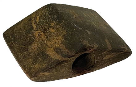
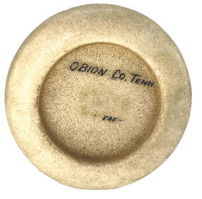
4" Quartz Discoidal. Obion Co, TN. Ex Townsend, ThompsonTony Putty Artifacts4.7(404)See Sold PriceMar 09, 2024
2 11/16" Quad. Grayson County, Kentucky. Davis COATony Putty Artifacts4.7(404)See Sold PriceMar 09, 2024
4 3/4" Cache Blade. Hornstone. Scott Co, KY. Pictured.Tony Putty Artifacts4.7(404)See Sold PriceMar 09, 2024
2 1/8" Cumberland. Hornstone. Hardin County, Kentucky.Tony Putty Artifacts4.7(404)See Sold PriceMar 09, 2024
Obsolete Jefferson County Kentucky State Police BadgeDiamond Auctions LLC4.3(10)See Sold PriceFeb 29, 2024
Mitchell - Map of the City of Washington (Washington, DC)Trillium Antique Prints & Rare Books4.5(30)See Sold PriceFeb 24, 2024
Carey, pub. 1796 - Map of KentuckyTrillium Antique Prints & Rare Books4.5(30)See Sold PriceFeb 24, 2024