ATLAS of ANTIENT GEOGRAPHY by SAMUEL BUTLER 1843John McInnis Auctioneers,LLC4.6(504)See Sold PriceFeb 24, 2024
18TH C. ANTIQUE MAP: FRENCH & INDIAN WAR, FRAMEDThomaston Place Auction Galleries4.4(389)See Sold PriceFeb 24, 2024
Rand McNally Railroad Map Cabinet w/ 21 Railroad MapsRail & Road Auctions4.6(165)See Sold PriceMar 08, 2024
Keith Haring - Ink on New York Map, Best Buddies, Inscribed, Signed, and DatedSapphire Auction Gallery4.1(67)See Sold PriceMar 02, 2024
LATE 17TH C. FRENCH MAP OF THE NEW WORLD BY ALEXIS-HUBERT JAILLOT (1632-1712)Thomaston Place Auction Galleries4.4(389)See Sold PriceFeb 24, 2024
Central Railroad of New Jersey Map of Sandy Hook Route-ca. 1903JM Hobby Supply and Railroad Artifact Auctions4.4(126)See Sold PriceFeb 24, 2024
Lot of Six Mixed Atlas Box Cars-HO Scale-New in BoxJM Hobby Supply and Railroad Artifact Auctions4.4(126)See Sold PriceFeb 25, 2024
Rand McNally/Santa Fe Railroad Map of Iowa-1912JM Hobby Supply and Railroad Artifact Auctions4.4(126)See Sold PriceFeb 24, 2024
NICOLAES VISSCHER (NETHERLANDS, 1618-1709) MAP OF THE NEW WORLDThomaston Place Auction Galleries4.4(389)See Sold PriceFeb 24, 2024
17TH C. WORLD MAP BY NICOLAES VISSCHER (NETHERLANDS, 1618-1709)Thomaston Place Auction Galleries4.4(389)See Sold PriceFeb 24, 2024
Lot of Six Mixed Atlas Cabooses-HO Scale-New in BoxJM Hobby Supply and Railroad Artifact Auctions4.4(126)See Sold PriceFeb 25, 2024
SoldMap of the Atlantic Coast Southern StatesMap of the Atlantic Coast of the Southern States North Carolina South Carolina Constructed and Engraved to Illustrate the War with the South Print Type: EngravingSee Sold Price
Map of the Atlantic Coast Southern StatesMap of the Atlantic Coast of the Southern States North Carolina South Carolina Constructed and Engraved to Illustrate the War with the South Print Type: ESee Sold Price
Map of the Atlantic Coast Southern StatesMap of the Atlantic Coast of the Southern States North Carolina South Carolina Constructed and Engraved to Illustrate the War with the South Print Type: ESee Sold Price
Map of the Atlantic Coast Southern StatesMap of the Atlantic Coast of the Southern States North Carolina South Carolina Constructed and Engraved to Illustrate the War with the South Print Type: EngravingSee Sold Price
Map of the Atlantic Coast Southern StatesMap of the Atlantic Coast of the Southern States North Carolina South Carolina Constructed and Engraved to Illustrate the War with the South Print Type: ESee Sold Price
Map of the Atlantic Coast Southern StatesMap of the Atlantic Coast of the Southern States North Carolina South Carolina br>Constructed and Engraved to Illustrate the War with the South Print Type: EnSee Sold Price
Map of the Atlantic Coast Southern StatesMap of the Atlantic Coast of the Southern States North Carolina South Carolina Constructed and Engraved to Illustrate the War with the South Print Type: EngraSee Sold Price
Sold3 Nautical Maps inc. Southern 18611st item: Nautical Map: A New Chart of the Western or Atlantic Ocean, Drawn from the Best Authorities by J. S. Norie, printed London, 1831. Shows the coasts of the United States, Labrador and EskmauxSee Sold Price
SoldTimetables from the South ACL AT&N G&F VgnA group of 8 public timetables from Southern States. Atlantic Coast Line 1887, AT&N 1929, Georgia & Florida 1928, Virginian 1930 and others including Illinois Central. Expect some wear, soiling, minorSee Sold Price
Atlantic Coast Map of the United States, 1864Map: Atlantic Coast of the United States (in Four Sheets) Date: 1864 Authors: U.S.C.S., U.S. COAST SURVEY Publisher: U.S.C.S. Size: Folio – 23.30 H x 27.60 W Inches "Sheet No.I Cape Sable to Sandy HSee Sold Price
North America Atlantic Coast of the United StatesTitle/Content of Map: North America Atlantic Coast of the United States Cartographer: L. DESSEZ/H. C. EVANS/U.S. COAST SURVEY Date: 1890-07-01 Publisher: U.S. NAVY HYDROGRAPHIC OFFICE Size: 44.25HeighSee Sold Price
USCGS: Antique Survey Map of US Atlantic Coast, 1889United States Coast and Geodetic survey sketch showing the progress of the survey in sections 3&4 June 30, 1888' USA ATLANTIC COAST:Chesapeake & Delaware Bay.Cape Fear & Lookout Date Printed: 1889 ImaSee Sold Price
Atlantic Coast of the United States (in Four Sheets).Title: Atlantic Coast of the United States (in Four Sheets). Sheet No. IV Mosquito Inlet To Key West Cartographer:BACHE, A.D. Publisher: U.S. COAST SURVEY Height: 23.5 Width: 27.3 Detailed map showingSee Sold Price
North America Atlantic Coast of the United StatesTitle: North America Atlantic Coast of the United States Publication Date: 1890-07-01 Publisher: U.S. NAVY HYDROGRAPHIC OFFICE Size: 44.25 x 29.5 "BUZZARD'S BAY TO CAPE LOOKOUT compiled from the latesSee Sold Price
North America Atlantic Coast of the United StatesReserve Reduced! Title: North America Atlantic Coast of the United States Publication Date: 1890-07-01 Cartographer: L. DESSEZ/H. C. EVANS/U.S. COAST SURVEY Publisher: U.S. NAVY HYDROGRAPHIC OFFICE SiSee Sold Price
North America. Atlantic Coast of the United States.Title: North America. Atlantic Coast of the United States. Cape Hatteras to Cape Canaveral. Compiled from the Latest U.S. Coast and British Admiralty Surveys. 1884 Publication Date: 1890-06-01 CartogrSee Sold Price
North America. Atlantic Coast of the United States. Cape Hatteras to Cape Canaveral. Compiled fromPublication Date: 1890-06-01 Title: North America. Atlantic Coast of the United States. Cape Hatteras to Cape Canaveral. Compiled from the Latest U.S. Coast and British Admiralty Surveys. 1884 CartogrSee Sold Price
Sea Chart Mid Atlantic StatesDessez, L. & Evans, H. C. North America Atlantic Coast of the United States. Lithographed Map. U.S. Navy Hydrographic Office, 1890. 44 ¼" x 29 ½" sheet. "BUZZARD'S BAY TO CAPE LOOKOUT compiled fSee Sold Price
U.S. Navy Chart On Linen - Definitive S. Atlantic CoastFillmore, John H. North America. Atlantic Coast of the United States. Cape Hatteras to Cape Canaveral... Lithographed map. U.S. Navy Hydrographic Office, 1890. 44" x 29 ¼" sheet. U.S. Navy chart, lSee Sold Price
SoldPictorial map of West Coast from S.P.R.RHeading: (United States - West Coast) Author: Bull, W.H. Title: Scenic Map of the Pacific Coast - Southern Pacific Line Place Published: [San Francisco?] Publisher: Date Published: 1923See Sold Price
SoldUS Cruise Line Brochures and Time Tables (9) (106542)Southern Pacific Steamship Lines, Black Ball Lines Puget Sound map, Dollar Steamship Line, California. American Export Lines deck plans, Eastern Steamship-Maine Coast, Southern Pacific Atlantic SteamsSee Sold Price
G. Woolworth ColtonÃs Hand Colored Map of theG. Woolworth ColtonÃs Hand Colored Map of the Pictorial History of War of 1861, Featuring the Mid Atlantic, Southern and Midwest of the United States Including the Indian Territory, p.166-7, FramedSee Sold Price
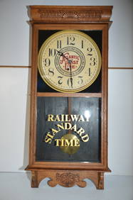
Atlantic Coast Line RR Station ClockJM Hobby Supply and Railroad Artifact Auctions4.4(126)See Sold PriceFeb 24, 2024
Timetable, Paper and Ephemera Lot-Eastern USA RailroadsJM Hobby Supply and Railroad Artifact Auctions4.4(126)See Sold PriceFeb 24, 2024
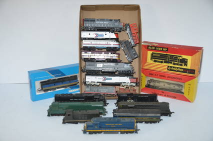
18 Non-Working/Dummy Locomotives-SSW/AMTRAK/ACL/PC/SP/NYC/CO/BO-HO ScaleJM Hobby Supply and Railroad Artifact Auctions4.4(126)See Sold PriceFeb 25, 2024
Group of Railroad Lapel Pins and Button - West Point Route, Texas & Pacific, Atlantic Coast Line,Rail & Road Auctions4.6(165)See Sold PriceMar 07, 2024
1887 Appletons' General Guide to the United State and Canada Part IIRail & Road Auctions4.6(165)See Sold PriceMar 08, 2024
Southern Africa Cape of Good Hope-Madagascar ADMIRALTY sea chart 1935 (1955) mapJasper524.5(9.8k)See Sold PriceFeb 28, 2024
Afrique. Benguela #44. Southern Angola & Northern Namibia. VANDERMAELEN 1827 mapJasper524.5(9.8k)See Sold PriceFeb 28, 2024
Partie de la Coste d'Afrique'. Southern Mauritania BELLIN/SCHLEY 1747 old mapJasper524.5(9.8k)See Sold PriceFeb 28, 2024
Partie Occidentale de l’Afrique. West Africa coast Canary islands BONNE 1788 mapJasper524.5(9.8k)See Sold PriceFeb 28, 2024
Coste Orientale d’Afrique'. South Africa Mozambique BELLIN/SCHLEY 1747 mapJasper524.5(9.8k)See Sold PriceFeb 28, 2024
Western coast of Africa… to the River Sanaga. Southern Mauritania LABAT 1745 mapJasper524.5(9.8k)See Sold PriceFeb 28, 2024
SOUTHERN AFRICA Monomotapa (Mutapa Kingdom) Cafrerie (Kaffraria) MALLET 1683 mapJasper524.5(9.8k)See Sold PriceFeb 28, 2024