ATLAS of ANTIENT GEOGRAPHY by SAMUEL BUTLER 1843John McInnis Auctioneers,LLC4.6(502)See Sold PriceFeb 24, 2024
18TH C. ANTIQUE MAP: FRENCH & INDIAN WAR, FRAMEDThomaston Place Auction Galleries4.4(386)See Sold PriceFeb 24, 2024
Rand McNally Railroad Map Cabinet w/ 21 Railroad MapsRail & Road Auctions4.6(165)See Sold PriceMar 08, 2024
Keith Haring - Ink on New York Map, Best Buddies, Inscribed, Signed, and DatedSapphire Auction Gallery4(67)See Sold PriceMar 02, 2024
LATE 17TH C. FRENCH MAP OF THE NEW WORLD BY ALEXIS-HUBERT JAILLOT (1632-1712)Thomaston Place Auction Galleries4.4(386)See Sold PriceFeb 24, 2024
Central Railroad of New Jersey Map of Sandy Hook Route-ca. 1903JM Hobby Supply and Railroad Artifact Auctions4.4(126)See Sold PriceFeb 24, 2024
Lot of Six Mixed Atlas Box Cars-HO Scale-New in BoxJM Hobby Supply and Railroad Artifact Auctions4.4(126)See Sold PriceFeb 25, 2024
Rand McNally/Santa Fe Railroad Map of Iowa-1912JM Hobby Supply and Railroad Artifact Auctions4.4(126)See Sold PriceFeb 24, 2024
NICOLAES VISSCHER (NETHERLANDS, 1618-1709) MAP OF THE NEW WORLDThomaston Place Auction Galleries4.4(386)See Sold PriceFeb 24, 2024
17TH C. WORLD MAP BY NICOLAES VISSCHER (NETHERLANDS, 1618-1709)Thomaston Place Auction Galleries4.4(386)See Sold PriceFeb 24, 2024
Lot of Six Mixed Atlas Cabooses-HO Scale-New in BoxJM Hobby Supply and Railroad Artifact Auctions4.4(126)See Sold PriceFeb 25, 2024
SoldJ. Stockdale A Map of Essex 1797, 54cm x 44cm - StockJ. Stockdale A Map of Essex 1797, 54cm x 44cm - Stock Ref:255-46See Sold Price
SoldJ. Stockdale A Map of Kent 1797, 53cm x 44cm - StockJ. Stockdale A Map of Kent 1797, 53cm x 44cm - Stock Ref:255-48See Sold Price
J. Stockdale A Map of Hartfordshire 1798, 52.5cm x 44cmJ. Stockdale A Map of Hartfordshire 1798, 52.5cm x 44cm - Stock Ref:255-47See Sold Price
SoldJ. Stockdale A Map of Surrey 1798, 52cm x 43cm - StockJ. Stockdale A Map of Surrey 1798, 52cm x 43cm - Stock Ref:255-45See Sold Price
SoldRed clouds, unsigned oil on canvas, housed in a giltRed clouds, unsigned oil on canvas, housed in a gilt frame, 54cm x 44cm - Stock Ref:8639-5See Sold Price
Sold5 Unframed Antique New Jersey MapsLot includes: 1794 J. Stockdale "A Map of New Jersey from the beft Authorities" (8 1/8" x 10 5/8"), 1855 JH Colton (Johnson & Browning) "Colton's New Jersey" (17 3/8" x 14 5/8"), GW & CB Colton 1855 PSee Sold Price
SoldMap of Essex, with cartouche "Essex Actually SurveyedMap of Essex, with cartouche "Essex Actually Surveyed with The Several Roads from London", by Thomas and John Bowles 1733, housed in a gilt and ebonised frame, the map 53cm x 42cm - Stock Ref:255-43See Sold Price
Map- J Stockdale, plan of the City of Venice, LondonMap- J Stockdale, plan of the City of Venice, London 1800, includes a key locating over 130 places of interest, 26.5 x 19cmSee Sold Price
SoldMap- J Stockdale, plan of the City of Venice, LondonMap- J Stockdale, plan of the City of Venice, London 1800, includes a key locating over 130 places of interest, 26.5 x 19cmSee Sold Price
Sold*Lake District Interest - Walter J. Roberts (20th Century), watercolour, 'Spring Time, Cartmel',*Lake District Interest - Walter J. Roberts (20th Century), watercolour, 'Spring Time, Cartmel', framed, mounted, and under glass, measuring 26cm x 36cm, & 44cm x 54cm overall, together with a JudSee Sold Price
Sold1858 J H French map of Essex Co, NY on original1858 J H French map of Essex Co, NY on original rollers- minor looses at top corners 54” x 60”See Sold Price
75: ENGRAVED/COLORED MAP, ESSEX COUNTY, N.YENGRAVED/COLORED MAP, ESSEX COUNTY, N.Y. 1829. 24 X 24See Sold Price
SoldOriginal railway carriage print by Henry J. Denham,Original railway carriage print by Henry J. Denham, Maldon, Essex, housed in a stained glazed frame with visible screw heads, the print 49.5cm x 24.5cm - Stock Ref:7561-6See Sold Price
Sold1798 (18th C.) Map The United States J. StockdalePublished by J. Stockdale ,Piccadilly on November 15th This wonderful partial map of the united states surrounding Philadelphia measures 17 1/4" x 20 1/2" and is in nice condition with some slight staSee Sold Price
SoldWikes: Antique Map of Canada, 1797Title/Content of Map: 1797 Canada Date Printed: 1797 Cartographer: J. Wikes Material/Medium: Paper Size: 7 1/2" x 9 1/2" Rare Map. Published in London. Hand colored copperplate engraved. Map shows BriSee Sold Price
Sold2 18th/19th C United States Maps1.) 1831 Map of the Eclipse of Feb 12th in its Passage Across the United States. Published by Gray and Bowen. 9" high x 8-3/4" wide. Cut from book. 2.) 1797 United States map. Published by J. Wilkes.See Sold Price
1803 English County Map of Essex1803 English county map of Essex printed by J. Wilkes at London. Very Good, measures 10 x 8.5". Please note that this lot has a confidential reserve. When you leave a bid in advance of the auction, suSee Sold Price
SoldA Newe Mape of Poland Done into English by J. SpeedeJOHN SPEEDE New Map of Poland, annotated to scaled key 'Humble 1626', framed, 54cm x 24cm, Edward Gordon label verso. CONDITION REPORT: Centre fold. Rather brown overall. Colours slightly faded to marSee Sold Price
Stockdale: Map of Eastern United States, 1798Map: 1798 Stockdale Map of Eastern United States -- Part of the United States of North America Cartographer: J. Stockdale Year / Place: 1798 London Map Dimensions: 18.4 x 16.2 in. Condition: Very GoodSee Sold Price
Stockdale: Map of Niagara Falls, 1798Map: 1798 Stockdale Map of Niagara Falls -- An Eye Sketch of the Falls of Niagara Cartographer: J. Stockdale Year / Place: 1798 London Map Dimensions: 6.5 x 9 in. Condition: Very Good. Light offset anSee Sold Price
Sold1798 Stockdale Map of Eastern United StatesTitle/Content of Map: 1798 Stockdale Map of Eastern United States -- Part of the United States of North America Date Printed: 1798 London Cartographer: J. Stockdale Size: 18.4 x 16.2 in. This antiqueSee Sold Price
Stockdale: Map of Niagara Falls, 1798Map: 1798 Stockdale Map of Niagara Falls -- An Eye Sketch of the Falls of Niagara Cartographer: J. Stockdale Year/Place: 1798 London Dimensions: 6.5 x 9 in. A relatively uncommon antique map of NiagarSee Sold Price
Sold18TH C ENGRAVED MAP OF THE VIRGIN ISLANDS18TH C ENGRAVED MAP OF THE VIRGIN ISLANDS Map engraving of the Virgin Islands for the History of the West Indies by J Stockdale, 18th century. Size: 7 x 9"See Sold Price
SoldCary (John) A reduced Map Of DorsetshireCary (J.) A reduced Map Of Dorsetshire From the Best Authorities, a map of the county, engraving with some hand-colouring, one central vertical fold, 380 x 530mm., J. Stockdale, 1805; with anoSee Sold Price
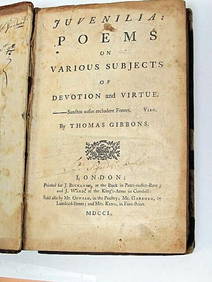
Thomas Gibbons Juvenalia 1750 Very Rare 1st Edition Full CalfLuis Porretta Fine Arts4.3(10)See Sold PriceMar 02, 2024
ORCHIDS Culture & Management 1st Edition c1903 ScarceLuis Porretta Fine Arts4.3(10)See Sold PriceMar 02, 2024
ALKEN / ACKERMAN Original Equestrian Aquatint Victorious Bunchclod c1847 FramedLuis Porretta Fine Arts4.3(10)See Sold PriceMar 02, 2024
A J HANDFORD British Lithographer Rome from Mount Aventi Signed c1910 FramedLuis Porretta Fine Arts4.3(10)See Sold PriceMar 02, 2024
SENATOR J.F.K. STERLING PEN & CAMPAIGN MATERIALSJohn McInnis Auctioneers,LLC4.6(502)See Sold PriceFeb 25, 2024
John Potter Wheat (American/ Mexican 1920-1980)Nadeau's Auction Gallery4.7(401)See Sold PriceFeb 24, 2024
1855 Map of New York & Erie Railroad and 1917 Trespassing On Railway Property Is A MisdemeanorRail & Road Auctions4.6(165)See Sold PriceMar 07, 2024
Pair of Early Railroad Maps - 1874 Delaware, Lackawanna & Western and 1876 Pennsylvania RailroadRail & Road Auctions4.6(165)See Sold PriceMar 07, 2024
Antique Oil on Canvas. Harbor Scene w/ShipMid-Hudson Auction Galleries4.4(468)See Sold PriceFeb 24, 2024
Roger de la Fresnaye (French, 1885-1925) - Académie d'HommeFreeman's | Hindman4.5(158)See Sold PriceFeb 27, 2024
1867 Map of the Railroads of The State of New YorkRail & Road Auctions4.6(165)See Sold PriceMar 08, 2024
[STOCKS]. [CARNEGIE, Andrew, 1835-1919]. United States Stee...Potter & Potter Auctions4.6(539)See Sold PriceMar 07, 2024
Keith Haring Artwork Signed on a Shell Oil New York Road Map 18 in. x 24 in.Donny Malone Auctions4.5(1.7k)See Sold PriceMar 04, 2024
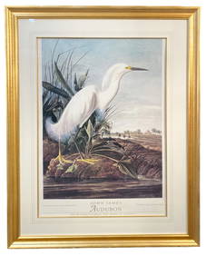
ORIGINAL JOHN J. AUDUBON (1785-1851) NATIONAL GALLERY OF ART EXHIBITION POSTER, 35IN x 43IN (89cm xThe Rug Life4.3(12)See Sold PriceMar 07, 2024
Mid Cent Painting sgnd F.T. J'Osias 24 x 39State Line Auctions & Estate Services4.6(275)See Sold PriceFeb 25, 2024
1764 Bellin Map of Lesser Antilles Northern Portion -- Petites Antilles ou Isles du Vent 3e. Partie.Jasper524.5(9.8k)See Sold PriceFeb 27, 2024
Continental Green Patinated Bronze Figure of a Faun, After the Antique, Chiurazzi FoundrySTAIR4.6(286)See Sold PriceMar 06, 2024


![[STOCKS]. [CARNEGIE, Andrew, 1835-1919]. United States Stee... (1 of 2)](https://p1.liveauctioneers.com/928/318880/171361200_1_x.jpg?height=282&quality=70&version=1707501302)