ATLAS of ANTIENT GEOGRAPHY by SAMUEL BUTLER 1843John McInnis Auctioneers,LLC4.6(504)See Sold PriceFeb 24, 2024
18TH C. ANTIQUE MAP: FRENCH & INDIAN WAR, FRAMEDThomaston Place Auction Galleries4.4(389)See Sold PriceFeb 24, 2024
Rand McNally Railroad Map Cabinet w/ 21 Railroad MapsRail & Road Auctions4.6(165)See Sold PriceMar 08, 2024
Keith Haring - Ink on New York Map, Best Buddies, Inscribed, Signed, and DatedSapphire Auction Gallery4.1(67)See Sold PriceMar 02, 2024
LATE 17TH C. FRENCH MAP OF THE NEW WORLD BY ALEXIS-HUBERT JAILLOT (1632-1712)Thomaston Place Auction Galleries4.4(389)See Sold PriceFeb 24, 2024
Central Railroad of New Jersey Map of Sandy Hook Route-ca. 1903JM Hobby Supply and Railroad Artifact Auctions4.4(126)See Sold PriceFeb 24, 2024
Lot of Six Mixed Atlas Box Cars-HO Scale-New in BoxJM Hobby Supply and Railroad Artifact Auctions4.4(126)See Sold PriceFeb 25, 2024
Rand McNally/Santa Fe Railroad Map of Iowa-1912JM Hobby Supply and Railroad Artifact Auctions4.4(126)See Sold PriceFeb 24, 2024
NICOLAES VISSCHER (NETHERLANDS, 1618-1709) MAP OF THE NEW WORLDThomaston Place Auction Galleries4.4(389)See Sold PriceFeb 24, 2024
17TH C. WORLD MAP BY NICOLAES VISSCHER (NETHERLANDS, 1618-1709)Thomaston Place Auction Galleries4.4(389)See Sold PriceFeb 24, 2024
Lot of Six Mixed Atlas Cabooses-HO Scale-New in BoxJM Hobby Supply and Railroad Artifact Auctions4.4(126)See Sold PriceFeb 25, 2024
Geological survey maps of S.F. Bay AreaHeading: (California - San Francisco Bay Area) Author: U.S. Geological Survey Title: Six maps of the San Francisco Bay Area issued by the U.S. Geological Survey Place Published: Washington, D.C. PubliSee Sold Price
Geological survey maps of S.F. Bay AreaHeading: (California - San Francisco Bay Area) Author: U.S. Geological Survey Title: Six maps of the San Francisco Bay Area issued by the U.S. Geological Survey Place Published: Washington, D.C. PubliSee Sold Price
SoldGeological Pocket Map of San Francisco Bay AreaTitle: Map Of The Region Adjacent To The Bay Of San Francisco. 1873. The Coast, Rancho, Township and Section Lines from Materials furnished by the U.S. Coast Survey and the U.S. Surveyor General's OffSee Sold Price
Geology Bay St. George Carboniferous Area NewfoundlandGeology of the Bay St. George Carboniferous area, (Newfoundland. Geological survey. [Bulletin). Hayes, Albert Orion. 1938. Later. Scarce. Map present. Some light yellowing to edges. Please note that tSee Sold Price
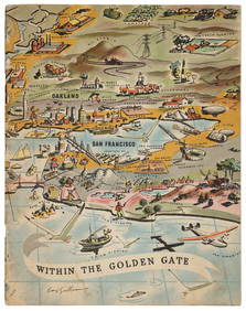
SoldRare pictorial map of S.F. Bay Area 1905Heading: Author: Whitaker & Ray Co. Title: New Relief Map of the Bay Counties Place Published: San Francisco Publisher: Date Published: 1905 Description: Lithographed map,See Sold Price
SoldRare "Grapho-relief" map of S.F. Bay Area 1907Heading: Author: Whitaker & Ray Co. Title: Grapho-Relief Map of the Bay Counties Compiled from the latest and most accurate Official Data Place Published: San Francisco Publisher: Date PublishedSee Sold Price
SoldRare Road Map of S.F. Bay Area 1907Heading: Author: Whitaker & Ray Co. Title: Road Map of the Bay Counties:Compiled from the latest and most accurate official data Place Published: San Francisco Publisher:Whitaker and Ray Co. DatSee Sold Price
SoldRoad map of greater S.F. Bay Area 1926Heading: (California - San Francisco Bay Area) Author: Title: Map of the South Bay touring district Place Published: No place Publisher:National Automobile Club. Date Published: 1926See Sold Price
Group of six maps to include Boston 1877 AugustusGroup of six maps to include Boston 1877 Augustus Mitchell Johnsons lower Canada, White Plains, Scarsdale, Switzerland, Roman Empire, Geological map San Francisco Bay Area 1853, print of California.See Sold Price
A FRAMED HAND COLOURED GEOLOGICAL SURVEY MAP, showingA FRAMED HAND COLOURED GEOLOGICAL SURVEY MAP, showing an area of Great Britain and the River Wye. 37 cm x 52 cm.See Sold Price
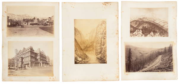
Sold6 US Geological Survey Maps Pisgah ForestCollection of six US Geological Survey topographical maps covering areas of the Tennessee River watershed including; 10 Horse Shoe, NC, 2) Shining Rock, NC, 3) Skyland, NC, 4) Rosman, NC, 5) StandingsSee Sold Price
6 US Geological Survey Maps Pisgah ForestCollection of six US Geological Survey topographical maps covering areas of the Tennessee River watershed including; 10 Horse Shoe, NC, 2) Shining Rock, NC, 3) Skyland, NC, 4) Rosman, NC, 5) StandiSee Sold Price
6 US Geological Survey Maps Pisgah ForestCollection of six US Geological Survey topographical maps covering areas of the Tennesseeï¾ River watershed including; 10 Horse Shoe, NC, 2) Shining Rock, NC, 3) Skyland, NC, 4) Rosman, NC, 5) StanSee Sold Price
SoldGeological Map of San Francisco Bay Area, 1853Title/Content of Map: 1853 Geological Map of San Francisco Bay Area for the Pacific Rail Road -- Geological Map of the Vicinity of San Francisco Date Printed: 1853, Philadelphia Cartographer: W BlakeSee Sold Price
Sold1930's Bay Area Survey Maps(lot of 4) San Joaquin River (1936), San Francisco: Candlestick Point to Angel Island (1937), Suisun Bay (1935), and Mare Island Strait (1939) Survey Maps, Published in Washington D.C By the U.S CoastSee Sold Price
Sold1930's Bay Area Survey Maps(lot of 6) (3) San Joaquin River (1933/1936), Sacramento River (1926), Suisun Bay (1935), and Pfeiffer Point to Cypress Point (1935) Survey Maps, Published in Washington D.C. by the U.S Coast and GeodSee Sold Price
Sold1930/40's Bay Area Survey Maps(lot of 4) San Francisco Entrance (1937) San Pablo Bay (1934), San Francisco Bay; Candlestick Point to Angel Island (1941- not reissued) Survey Maps, Published in Washington D.C by the U.S Coast and GSee Sold Price
Sold1930's Bay Area Survey Maps(lot of 4) San Joaquin River (1936), San Francisco: Candlestick Point to Angel Island (1937), Suisun Bay (1935), and Mare Island Strait (1939) Survey Maps, Published in Washington D.C By the U.S CoastSee Sold Price
Sold1930's Bay Area Survey Maps(lot of 6) (3) San Joaquin River (1933/1936), Sacramento River (1926), Suisun Bay (1935), and Pfeiffer Point to Cypress Point (1935) Survey Maps, Published in Washington D.C. by the U.S Coast and GeodSee Sold Price
SoldMaps and Books of S.F. Bay Area (120358)Lot of 6. 1. Sunset Sportsman[x=#8217/]s Atlas. S.F. Bay and Delta Area. 1955. Information on fishing, maps of boat liveries and hunting. Detailed maps. 2. The San Quentin Story by Warden Clinton T. DSee Sold Price
Antique Geological Map of San Francisco Bay Area, 1853Title/Content of Map: 1853 Geological Map of San Francisco Bay Area for the Pacific Rail Road -- Geological Map of the Vicinity of San Francisco Date Printed: 1853, Philadelphia Cartographer: W BlakeSee Sold Price
Sold1867 Geological Survey Map of San Francisco BayTitle: Map of the Region Adjacent to the Bay of San Francisco Author: Whitney, J.D., State Geologist Description: Folding linen-backed lithographed topographical map of the San Francisco Bay Region, wSee Sold Price
Sold1867 Geological Survey Map of San Francisco BayHeading: Author: California, State Geological Survey Title: Map of the Region Adjacent to the Bay of San Francisco. J.D. Whitney, State Geologist, W.H. Bewer, W.M. Gabb and A. Rémond, Assistants. C.See Sold Price
California New Indexed Atlas of the WorldTitle: California New Indexed Atlas of the World Publication Date: 1887 Cartographer: RAND, MCNALLY & CO. Publisher: RAND, MCNALLY & CO. Size: 19 x 13.5 Map with inset of S.F. & Bay area. Quite detailSee Sold Price
Jerusalem Map for British Soldiers in Palestine - WW2Levy Auction House4.3(11)See Sold PriceFeb 27, 2024
Proposed Sportsground Map - Haifa, Palestine - 1926Levy Auction House4.3(11)See Sold PriceFeb 27, 2024
Nottingham.- Ordnance Survey Office (publisher) Collection 8 geological maps on the environs ofForum Auctions4.3(53)See Sold PriceFeb 29, 2024
Stanford, Edward 1901 Large Map. Geological Map of the British IslesAlbion Auctions4.6(341)See Sold PriceMar 01, 2024
Virginia and West Virginia Topography MapsRapid Estate Liquidators and Auction Gallery4.5(1.1k)See Sold PriceFeb 28, 2024