ATLAS of ANTIENT GEOGRAPHY by SAMUEL BUTLER 1843John McInnis Auctioneers,LLC4.5(505)See Sold PriceFeb 24, 2024
18TH C. ANTIQUE MAP: FRENCH & INDIAN WAR, FRAMEDThomaston Place Auction Galleries4.4(393)See Sold PriceFeb 24, 2024
Rand McNally Railroad Map Cabinet w/ 21 Railroad MapsRail & Road Auctions4.6(165)See Sold PriceMar 08, 2024
Keith Haring - Ink on New York Map, Best Buddies, Inscribed, Signed, and DatedSapphire Auction Gallery4(67)See Sold PriceMar 02, 2024
LATE 17TH C. FRENCH MAP OF THE NEW WORLD BY ALEXIS-HUBERT JAILLOT (1632-1712)Thomaston Place Auction Galleries4.4(393)See Sold PriceFeb 24, 2024
Central Railroad of New Jersey Map of Sandy Hook Route-ca. 1903JM Hobby Supply and Railroad Artifact Auctions4.4(127)See Sold PriceFeb 24, 2024
Lot of Six Mixed Atlas Box Cars-HO Scale-New in BoxJM Hobby Supply and Railroad Artifact Auctions4.4(127)See Sold PriceFeb 25, 2024
Rand McNally/Santa Fe Railroad Map of Iowa-1912JM Hobby Supply and Railroad Artifact Auctions4.4(127)See Sold PriceFeb 24, 2024
NICOLAES VISSCHER (NETHERLANDS, 1618-1709) MAP OF THE NEW WORLDThomaston Place Auction Galleries4.4(393)See Sold PriceFeb 24, 2024
17TH C. WORLD MAP BY NICOLAES VISSCHER (NETHERLANDS, 1618-1709)Thomaston Place Auction Galleries4.4(393)See Sold PriceFeb 24, 2024
Lot of Six Mixed Atlas Cabooses-HO Scale-New in BoxJM Hobby Supply and Railroad Artifact Auctions4.4(127)See Sold PriceFeb 25, 2024
SoldAN ANTIQUE MAP, "Map of Oklahoma and Indian Territory,"AN ANTIQUE MAP, "Map of Oklahoma and Indian Territory," 1890-1892, color engraving on paper, copyrighted by Mast, Crowell & Kirkpatrick, with view of Beaver. 10.375" x 13" Note: Showing populations oSee Sold Price
SoldAntique Map : Oklahoma Indian Territory - 1903Antique Map : Oklahoma Indian Territory - 1903. Size : 21.5" x 13.5"See Sold Price
SoldAN ANTIQUE MAP OF OKLAHOMA, "Indian Territory,"AN ANTIQUE MAP OF OKLAHOMA, "Indian Territory," CHICAGO, CIRCA 1901, color engraving on paper, published by George F. Cram (1842-1948), a page fragment from Cram's Modern Atlas The New Unrivaled.See Sold Price
SoldAN ANTIQUE MAP, "The Century Atlas, Oklahoma and IndianAN ANTIQUE MAP, "The Century Atlas, Oklahoma and Indian Territory," 1897-1933, color print on paper, "Copyright 1897, by The Century Co., New York," printed by "The Matthews-Northup Co., Buffalo,See Sold Price
Sold[Nine American Indian Territory Maps][Nine Antique American Indian Territory Maps], including "Map of Indian Territory and Oklahoma", 1890, NY, Julius Bien; "Map of the Navajo Indian Reservation", 1886, Santa Fe; "Outline Map of the FielSee Sold Price
SoldAN ANTIQUE MAP, "Rand McNally & Co. New Business AtlasAN ANTIQUE MAP, "Rand McNally & Co. New Business Atlas Map of Indian Territory & Oklahoma," CHICAGO, CIRCA 1892, color engraving on paper, with view of Beaver County, a page fragment from Indexed AtlaSee Sold Price
AN ANTIQUE MAP, "Rand McNally & Co.'s New BusinessAN ANTIQUE MAP, "Rand McNally & Co.'s New Business Atlas Map of Indian Territory and Oklahoma," CIRCA 1903, color engraving on paper, showing chief cities, populations, and numbered railroad lines, paSee Sold Price
SoldAN ANTIQUE MAP, "Rand McNally & Co.'s New BusinessAN ANTIQUE MAP, "Rand McNally & Co.'s New Business Atlas Map of Indian Territory and Oklahoma," CIRCA 1903, color engraving on paper, showing chief cities, populations, and numbered railroad lines, paSee Sold Price
SoldRand McNally: Antique Map of Texas & Indian TerritoryTitle/Content of Map: 1895 Rand McNally Map of Texas and Indian Territory/Oklahoma -- Texas; Oklahoma and Indian Territory Date Printed: 1895 Chicago Cartographer: Rand McNally Size: 9.2 x 12.5 in. CoSee Sold Price
SoldRand McNally: Antique Map of Texas & Indian TerritoryMap: 1895 Rand McNally Map of Texas and Indian Territory/Oklahoma -- Texas; Oklahoma and Indian Territory Cartographer: Rand McNally Year / Place: 1895 Chicago Map Dimensions: 9.2 x 12.5 in. ConditionSee Sold Price
Rand McNally: Antique Map of Texas & Indian TerritoryTitle/Content of Map: 1895 Rand McNally Map of Texas and Indian Territory/Oklahoma -- Texas; Oklahoma and Indian Territory Date Printed: 1895 Chicago Cartographer: Rand McNally Size: 9.2 x 12.5 in. ThSee Sold Price
Rand McNally: Antique Map Texas, Indian Territory, 1895Title/Content of Map: 1895 Rand McNally Map of Texas and Indian Territory/Oklahoma -- Texas; Oklahoma and Indian Territory Date Printed: 1895 Chicago Cartographer: Rand McNally Size: 9.2 x 12.5 in. ThSee Sold Price
SoldAN ANTIQUE MAP, "Rand McNally & Co.'s New 11" x 14" MapAN ANTIQUE MAP, "Rand McNally & Co.'s New 11" x 14" Map of Indian Territory and Oklahoma," CHICAGO, CIRCA 1895, color engraving on paper, showing the "Western portion of Oklahoma," the border lisSee Sold Price
Rand McNally: Antique Map of Texas and Indian TerritoryTitle/Content of Map: 1895 Rand McNally Map of Texas and Indian Territory/Oklahoma -- Texas; Oklahoma and Indian Territory Date Printed: 1895 Chicago Cartographer: Rand McNally Size: 9.2 x 12.5 in. ThSee Sold Price
1896 Rand McNally Antique Map of Texas Indian TerritoryTitle/Content of Map: 1896 Rand McNally Map of Texas and Indian Territory/Oklahoma -- Texas [verso] Oklahoma and Indian Territory Date Printed: 1896 Chicago Cartographer: Rand McNally Size: 9.2 x 12.5See Sold Price
SoldAN ANTIQUE MAP, "Map of Indian Territory ShowingAN ANTIQUE MAP, "Map of Indian Territory Showing Distribution of Woodland," NEW YORK, 1899, color lithograph, published by Julius Bien (1826-1909), "Compiled under the direction of C.H. Fitch by GilbeSee Sold Price
SoldAN ANTIQUE MAP, "Map of Oklahoma and Indian Ters.,"AN ANTIQUE MAP, "Map of Oklahoma and Indian Ters.," CHICAGO, CIRCA 1900, color engraving, published by George F. Cram (1842-1928). 14" x 20" Provenance: Property from a Fortune 500 Energy Company, HouSee Sold Price
SoldAN ANTIQUE SURVEY MAP, "Map of the Indian Territory,AN ANTIQUE SURVEY MAP, "Map of the Indian Territory, Exhibit B," WASHINGTON D.C., June 30, 1902, color lithograph on paper, "Showing the progress and status of townsite surveys, under the direction ofSee Sold Price
SoldAN ANTIQUE MAP, "Railroad and County Map of IndianAN ANTIQUE MAP, "Railroad and County Map of Indian Territory," New York, 1885-1893, hand colored engraving on paper, published by A.A. Grant, plates 165-165, page fragments from an atlas. 16 1/2" x 22See Sold Price
Sold1892 Lippencott Map of Texas, Oklahoma and IndianReserve Reduced! Title/Content of Map: 1892 Lippencott Map of Texas, Oklahoma and Indian Territory -- Texas, Oklahoma & Indian Territory Date: 1892, Edinburgh Cartographer: J Lippencott Size: 11.3 X 9See Sold Price
1892 Cram Map of Texas [verso] Oklahoma and IndianTitle/Content of Map: 1892 Cram Map of Texas [verso] Oklahoma and Indian Territory [verso] Arkansas -- Texas [verso] Oklahoma and Indian Ters. [verso] Arkansas Cartographer: G Cram Year/Place: 1892, CSee Sold Price
1892 Cram Map of Texas [verso] Oklahoma and IndianTitle/Content of Map: 1892 Cram Map of Texas [verso] Oklahoma and Indian Territory [verso] Arkansas -- Texas [verso] Oklahoma and Indian Ters. [verso] Arkansas Cartographer: G Cram Year/Place: 1892, CSee Sold Price
SoldAN ANTIQUE MAP, "Indian Territory Showing TownsitesAN ANTIQUE MAP, "Indian Territory Showing Townsites Approved to June 30, 1902," NEW YORK, color engraving on paper, "The Ninth Annual Report Commission to the Five Civilized Tribes," Exhibit 6, preparSee Sold Price
General Land Office Antique Map Indian Territory, 1883Title/Content of Map: 1883 General land Office Map of Indian Territory -- Indian Territory Date Printed: 1883, Washington Cartographer: General Land Office Size: 12 x 16 in. This is a highly detailedSee Sold Price
18TH C. ANTIQUE MAP: FRENCH & INDIAN WAR, FRAMEDThomaston Place Auction Galleries4.4(393)See Sold PriceFeb 24, 2024
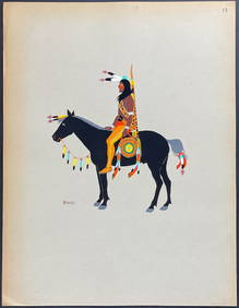
Kiowa Indian Art - Mopope: Kiowa Warrior on HorsebackTrillium Antique Prints & Rare Books4.5(32)See Sold PriceFeb 24, 2024
Kiowa Indian Art - Mopope: Kiowa Warrior and wifeTrillium Antique Prints & Rare Books4.5(32)See Sold PriceFeb 24, 2024
Carte du Canal de Mosambique…. Madagascar Bonne Esperance. BONNE 1780 mapJasper524.5(9.9k)See Sold PriceFeb 28, 2024
Northwest Africa. Morocco Sahara Rio do Oro Ain Sefra Gardaia. STANFORD 1904 mapJasper524.5(9.9k)See Sold PriceFeb 28, 2024
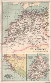
MOROCCO LIBERIA & MAURITIUS. Sierra Leone. BARTHOLOMEW 1886 old antique mapJasper524.5(9.9k)See Sold PriceFeb 28, 2024
AFRICA. Shows Mountains of Kong/the Moon. Caravan routes. RAPKIN/TALLIS 1851 mapJasper524.5(9.9k)See Sold PriceFeb 28, 2024
North & West Africa. Dahomey. Gold Coast. Military Territory. THE TIMES 1922 mapJasper524.5(9.9k)See Sold PriceFeb 28, 2024
Northwest Africa. Morocco Sahara Rio do Oro Ain Sefra Gardaia. STANFORD 1904 mapJasper524.5(9.9k)See Sold PriceFeb 28, 2024
Blackie (Pub) 1882 Folio Map. East Indies - Indian ArchipelagoAlbion Auctions4.6(341)See Sold PriceMar 01, 2024
Robert H Labberton - Map of The Territory of the Present United States - The territory of theProverde Auctions4.3(3)See Sold PriceFeb 28, 2024


![[Nine American Indian Territory Maps] (1 of 10)](https://p1.liveauctioneers.com/268/66576/33774620_1_x.jpg?height=282&quality=70&version=1421356640)


![1892 Cram Map of Texas [verso] Oklahoma and Indian (1 of 3)](https://p1.liveauctioneers.com/5584/182355/91727175_1_x.jpg?height=282&quality=70&version=1603285541)
![1892 Cram Map of Texas [verso] Oklahoma and Indian (1 of 3)](https://p1.liveauctioneers.com/5584/173638/87405881_1_x.jpg?height=282&quality=70&version=1594766493)