ATLAS of ANTIENT GEOGRAPHY by SAMUEL BUTLER 1843John McInnis Auctioneers,LLC4.6(502)See Sold PriceFeb 24, 2024
18TH C. ANTIQUE MAP: FRENCH & INDIAN WAR, FRAMEDThomaston Place Auction Galleries4.4(386)See Sold PriceFeb 24, 2024
Rand McNally Railroad Map Cabinet w/ 21 Railroad MapsRail & Road Auctions4.6(165)See Sold PriceMar 08, 2024
Keith Haring - Ink on New York Map, Best Buddies, Inscribed, Signed, and DatedSapphire Auction Gallery4(67)See Sold PriceMar 02, 2024
LATE 17TH C. FRENCH MAP OF THE NEW WORLD BY ALEXIS-HUBERT JAILLOT (1632-1712)Thomaston Place Auction Galleries4.4(386)See Sold PriceFeb 24, 2024
Central Railroad of New Jersey Map of Sandy Hook Route-ca. 1903JM Hobby Supply and Railroad Artifact Auctions4.4(126)See Sold PriceFeb 24, 2024
Lot of Six Mixed Atlas Box Cars-HO Scale-New in BoxJM Hobby Supply and Railroad Artifact Auctions4.4(126)See Sold PriceFeb 25, 2024
Rand McNally/Santa Fe Railroad Map of Iowa-1912JM Hobby Supply and Railroad Artifact Auctions4.4(126)See Sold PriceFeb 24, 2024
NICOLAES VISSCHER (NETHERLANDS, 1618-1709) MAP OF THE NEW WORLDThomaston Place Auction Galleries4.4(386)See Sold PriceFeb 24, 2024
17TH C. WORLD MAP BY NICOLAES VISSCHER (NETHERLANDS, 1618-1709)Thomaston Place Auction Galleries4.4(386)See Sold PriceFeb 24, 2024
Lot of Six Mixed Atlas Cabooses-HO Scale-New in BoxJM Hobby Supply and Railroad Artifact Auctions4.4(126)See Sold PriceFeb 25, 2024
1855 Colton Map of the United States -- The UnitedTitle/Content of Map: 1855 Colton Map of the United States -- The United States of America Date: 1855, New York Cartographer: J Colton Size: 14.6 X 25 in. This is an outstanding large US map. It doesSee Sold Price
1855 Colton Map of the United States -- The UnitedTitle/Content of Map: 1855 Colton Map of the United States -- The United States of America Date: 1855, New York Cartographer: J Colton Size: 14.6 X 25 in. This is an outstanding large US map. It doesSee Sold Price
1855 Colton Map of the United States -- The UnitedTitle/Content of Map: 1855 Colton Map of the United States -- The United States of America Date: 1855, New YorkCartographer: J Colton Size: 14.6 X 25 in. This is an outstanding large US map. It does fSee Sold Price
1855 Colton Map of the United States -- The UnitedTitle/Content of Map: 1855 Colton Map of the United States -- The United States of America Date: 1855, New York Cartographer: J Colton Size: 14.6 X 25 in. This is an outstanding large US map. It doesSee Sold Price
SoldJ. H. Colton: Map of United States of America, 1855The United States of America. J. H. Colton, 1855. 15.75 x 26. From the 1856 second edition of Colton’s Atlas of the World. Clean with very minor edge toning. Couple of tiny margin spots. One extremeSee Sold Price
SoldColton's Map of the United StatesColton's Map of the United States. c. 1855. Railroads, canals and stagecoach roads. 26 1/2" x 30 1/4". A Prominent Buffalo, NY Family.See Sold Price
1855 Colton Map of Washington DC -- Georgetown and theReserve Reduced! Title/Content of Map: 1855 Colton Map of Washington DC -- Georgetown and the City of Washington the Capital of the United States of America Date: 1855, New York Cartographer: J ColtonSee Sold Price
Sold1855 map of United StatesHeading: Author: Cummings & Hillliard Title: The United States Place Published: Boston Publisher: Date Published: c.1815 Description: Copper-engraved map, hand-colored. 20.See Sold Price
SoldColton Wall Map of U.S. 1855Title: Colton's Map of the United States of America, the British Provinces, Mexico and the West Indies, Showing the Country from the Atlantic to the Pacific Ocean Author: Colton, J.H. Description: LitSee Sold Price
SoldColton: Antique Map of United States of America, 1864Map: Colton's United States of America. Unusual Idaho Includes Colored, Un-named Montana and Wyoming - Rare Publication Date: 1864 Authors: J.H. COLTON, COLTON, JOSEPH HUTCHINS Publisher: J.H. COLTONSee Sold Price
SoldJ.H. Colton, "Map of the United States, the BritishJ.H. Colton, "Map of the United States, the British Provinces and Mexico, Showing the Routes of the U.S. Mail Steam Packets to California, and a Plan of the Gold Region" (New York, Colton 1849); ThisSee Sold Price
SoldColton MAP OF THE UNITED STATES THE CANADAS &C 1853Details: COLTON, J.H. (1800-1893). Colton's Map of the United States the Canadas &c. Showing the Rail Roads, Canals & Stage Roads with Distances from Place to Place. New York: Colton, 1853. Folding pSee Sold Price
SoldJ.H. Colton Map of the United States of America, c 1849J.H. Colton Map of the United States of America, c 1849. 1st edition wall version drawn by George W. Colton and engraved by John M. Atwood with the grapevine border design with small vignettes done anSee Sold Price
1862 Colton Map of the United States -- Colton's NewTitle/Content of Map: 1862 Colton Map of the United States -- Colton's New Railroad & County Map of the United States the Canadas &c. Date: 1862, New York Cartographer: J Colton Size: 33.1 X 39 in. ThSee Sold Price
1862 Colton Map of the United States -- Colton's NewTitle/Content of Map: 1862 Colton Map of the United States -- Colton's New Railroad & County Map of the United States the Canadas &c. Date: 1862, New York Cartographer: J Colton Size: 33.1 X 39 in. ThSee Sold Price
SoldColton folding map of United States 1859Heading: Author: Colton, George Woolworth Title: Map of the United States of America, The British Provinces, Mexico, the West Indies and Central America with part of New Granada and Venezuela Place PSee Sold Price
SoldJ.H. COLTON MAP OF THE UNITED STATESJ.H. COLTON MAP OF THE UNITED STATES British Provinces, Mexico and Colorado, showing the routes of the U.S. Mail Steam Packets to California and a plan of the Gold Region. Published by J.H. Colton, 86See Sold Price
Sold1862 Colton Map of the United States -- Colton's NewTitle/Content of Map: 1862 Colton Map of the United States -- Colton's New Railroad & County Map of the United States the Canadas &c. Cartographer: J Colton Year/Place: 1862, New York Size: 33.1 X 39See Sold Price
SoldColton.Map of the United StatesColton (J.H., publisher) Colton's Map of the United States,The Canadas &c., engraved map, original outline hand-colouring, 695 x 860mm., New York, Johnson & Brownrigg, 1859 § Wyld (JaSee Sold Price
SoldColton wall map of United States 1853Title: Colton's Map of the United States of America, the British Provinces, Mexico and the West Indies, Showing the Country from the Atlantic to the Pacific Ocean Author: Colton, Joseph Hutchins DescrSee Sold Price
SoldColton, Map of the United States, 1849Map of the United States the British Provinces Mexico.... Showing the Routes of the U.S. Mail Steam Packets to California, and a Plan of the Gold Region. New York: J.H. Colton, 1849. Drawn & EngravedSee Sold Price
SoldColton's Map of the United States of America datedColton's Map of the United States of America dated 1866, some paper loss!See Sold Price
J. H. Colton: United StatesMap: Colton’s United States of America Maker: J. H. Colton Publisher: G.W & C.B. Colton & Co. Size: Large Folio, 16.5 inches high x 27.5 inches wide Date: 1867 Please note that this lot has a reservSee Sold Price
SoldFramed and matted 1850 "Colton's Map of the UnitedFramed and matted 1850 "Colton's Map of the United States and the Canadas Showing the Rail Roads, Canals and Stage Roads…". Site- 26"x30"See Sold Price
American Express/New York Central Railroad Map of the United States-1934JM Hobby Supply and Railroad Artifact Auctions4.4(126)See Sold PriceFeb 24, 2024
Union Pacific RR Map of the United States-1926JM Hobby Supply and Railroad Artifact Auctions4.4(126)See Sold PriceFeb 24, 2024
United States Map with American Flag 3-D Wall Mount PaintingWeatherham Estate Treasures3.9(157)See Sold PriceFeb 29, 2024
Wilson - Wood Thrush, Red-breasted Thrush or Robin, & Nuthatches. 2Trillium Antique Prints & Rare Books4.5(30)See Sold PriceFeb 24, 2024
Wilson - Grosbeak, Warbler, Siskin, & Flycatcher. 17Trillium Antique Prints & Rare Books4.5(30)See Sold PriceFeb 24, 2024
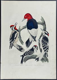
Wilson - Woodpeckers - Red-headed, Yellow-bellied, Hairy, & Downy. 9Trillium Antique Prints & Rare Books4.5(30)See Sold PriceFeb 24, 2024
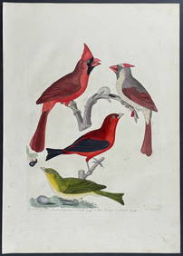
Wilson - Cardinal Grosbeak & Red Tanager. 11Trillium Antique Prints & Rare Books4.5(30)See Sold PriceFeb 24, 2024
Wilson - Mottled Owl, Lark, Creeper, & Warbler. 19Trillium Antique Prints & Rare Books4.5(30)See Sold PriceFeb 24, 2024
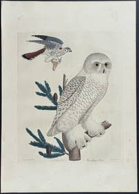
Wilson - Snow Owl (Snowy Owl) & Sparrow Hawk. 32Trillium Antique Prints & Rare Books4.5(30)See Sold PriceFeb 24, 2024
Wilson - Ivory-billed Woodpecker, Red-headed & Pileated Woodpeckers. 29Trillium Antique Prints & Rare Books4.5(30)See Sold PriceFeb 24, 2024
Wilson - Carolina Parrot & Flycatchers. 26Trillium Antique Prints & Rare Books4.5(30)See Sold PriceFeb 24, 2024
A23 United States in the Caribbean Denoyer-Geppert Social Science MapsJasper524.5(9.8k)See Sold PriceFeb 27, 2024
Cooke, George 1801 Antique Map. United States of AmericaAlbion Auctions4.6(336)See Sold PriceMar 01, 2024
Robert H Labberton - Map of The Territory of the Present United States - The territory of theProverde Auctions4.3(3)See Sold PriceFeb 28, 2024
Map of United States of North America, 1785Antiques Online Auctions4.6(407)See Sold PriceMar 14, 2024
Vintage 1920s Rand McNally Auto Trails MapThe Benefit Shop Foundation Inc.4.3(2.9k)See Sold PriceMar 20, 2024