ATLAS of ANTIENT GEOGRAPHY by SAMUEL BUTLER 1843John McInnis Auctioneers,LLC4.5(505)See Sold PriceFeb 24, 2024
18TH C. ANTIQUE MAP: FRENCH & INDIAN WAR, FRAMEDThomaston Place Auction Galleries4.4(393)See Sold PriceFeb 24, 2024
Rand McNally Railroad Map Cabinet w/ 21 Railroad MapsRail & Road Auctions4.6(165)See Sold PriceMar 08, 2024
Keith Haring - Ink on New York Map, Best Buddies, Inscribed, Signed, and DatedSapphire Auction Gallery4(67)See Sold PriceMar 02, 2024
LATE 17TH C. FRENCH MAP OF THE NEW WORLD BY ALEXIS-HUBERT JAILLOT (1632-1712)Thomaston Place Auction Galleries4.4(393)See Sold PriceFeb 24, 2024
Central Railroad of New Jersey Map of Sandy Hook Route-ca. 1903JM Hobby Supply and Railroad Artifact Auctions4.4(127)See Sold PriceFeb 24, 2024
Lot of Six Mixed Atlas Box Cars-HO Scale-New in BoxJM Hobby Supply and Railroad Artifact Auctions4.4(127)See Sold PriceFeb 25, 2024
Rand McNally/Santa Fe Railroad Map of Iowa-1912JM Hobby Supply and Railroad Artifact Auctions4.4(127)See Sold PriceFeb 24, 2024
NICOLAES VISSCHER (NETHERLANDS, 1618-1709) MAP OF THE NEW WORLDThomaston Place Auction Galleries4.4(393)See Sold PriceFeb 24, 2024
17TH C. WORLD MAP BY NICOLAES VISSCHER (NETHERLANDS, 1618-1709)Thomaston Place Auction Galleries4.4(393)See Sold PriceFeb 24, 2024
Lot of Six Mixed Atlas Cabooses-HO Scale-New in BoxJM Hobby Supply and Railroad Artifact Auctions4.4(127)See Sold PriceFeb 25, 2024
SoldPhilips' Authentic Imperial Maps for Tourists andHeading: (Maps) Author: Title: Philips' Authentic Imperial Maps for Tourists and Travellers: South America Place Published: London Publisher:George Philip & Son Ltd. Date Published: No date<See Sold Price
Philips' Authentic Imperial Maps for Tourists andHeading: (South America) Author: Title: Philips' Authentic Imperial Maps for Tourists and Travellers: South America Place Published: London Publisher:George Philip & Son Ltd. Date Published:See Sold Price
SoldAN ANTIQUE MAP, "United States (South Central),"AN ANTIQUE MAP, "United States (South Central)," LIVERPOOL, GREAT BRITAIN, 1891-1917, a color engraving on paper,"Philips' Authentic Imperial Maps for Tourists and Travelers," printed by George PhilipSee Sold Price
World On Mercator's Projection.Title: World On Mercator's Projection. Publication Date: c1925 Cartographer:PHILIP, GEORGE & SON Publisher: THE LONDON GEOGRAPHICAL INSTITUTE Brief Description: (Philip's Authentic Imperial maps. ForSee Sold Price
SoldWilliams, W.L.First Lesson in the Maori Language. [ plus map] Auck: Upton and Co 1904, 5th ed, loose hinges. 2. Philip's Authentic Maps - New Zealand. Paper map mounted on cloth and folded in green cloth covers. LnSee Sold Price
SoldRare pictorial tourist map of Imperial Valley, Cal.Heading: (California - Imperial Valley) Author: Pique, Ethel Title: Points of Interest in Imperial Valley, Land of Sunshine & Romance Place Published: El Centro, Calif. Publisher:El Centro Chamber ofSee Sold Price
Three early 20th century hardback books comprising TheThree early 20th century hardback books comprising The Authentic Map Directory of South Lancashire published by Geographia, Philips Handy Atlas of the Countries of England and G Freytag's Welt-Atlas pSee Sold Price
Bulkeley, John - John Cummins A Voyage to theLondon: Jacob Robinson, 1743. First edition, 8vo, modern half calf, early ownership signature to title-page, some light browning [ESTC T142350]; Philips, John An Authentic Journal of the late ExpeditiSee Sold Price
Authentic Antique 19th C. Maps-Provinces ofAuthentic Antique 19th C. Maps-Provinces of France-Engravings-Set Of 6 Set of six (6) imperial folio sized engraved pictorial maps from mid-19th century of departments (counties/provinces) of France aSee Sold Price
"ZELL'S IMPERIAL LIBRARY ATLAS," Circa 1878"ZELL'S IMPERIAL LIBRARY ATLAS," Circa 1878. Hard cover. A series of new and authentic maps, engraved from original drawings, accompanied by an index of reference. Edited by William Hughes, .F.R.G.S.See Sold Price
SoldCrofutt's Trans-Continental Guide 1874Heading: Author: Crofutt, George A. Title: Crofutt's Trans-Continental Tourist, Containing a Full and Authentic Description of Over Five Hundred Cities, Towns, Villages, Stations, Government Forts anSee Sold Price
Faberge - Authentic Imperial Egg FabergeFaberge egg.Excellent condition.Dimensions of the egg ca 6cmSee Sold Price
Sold1960's Authentic Imperial Tex-Tan Western Saddle Hand1960's Authentic Tex-Tan Western Saddle Hand Tooled: Gorgeous Tex-Tan Saddle, hand tooled. Serial number on saddle reads 104V AXFD804. Hand tooled with stunning rosettes, scrolling and such.See Sold Price
Sold1960's Authentic Imperial Tex-Tan Western Saddle Hand1960's Authentic Tex-Tan Western Saddle Hand Tooled: Gorgeous Tex-Tan Saddle, hand tooled. Serial number on saddle reads 104V AXFD804. Hand tooled with stunning rosettes, scrolling and such.See Sold Price
SoldA SET OF FIVE ANTIQUE RUSSIAN IMPERIAL MAPSThe lot includes 5 19th-century maps of Russian territories: Sketch of the Acquisitions of Russia in Europe and Central Asia since the Accession of Peter 1st to the Throne; Carte de la Russie D'Asie SSee Sold Price
SoldA SET OF FOUR ANTIQUE RUSSIAN IMPERIAL MAPSIncludes: The Russian Empire with its gradual Acquisitions traced and Explained; Russian in Europe, Sweden and Norway; Asiatiska Ryssland; The Aral sea according to Khanikoff drawn by Augustus PetermaSee Sold Price
SoldFaberge - Authentic Imperial Egg FabergeFaberge egg, excellent conditionDimensions of the egg ca 6cmSee Sold Price
Faberge - Authentic Imperial Egg FabergeFaberge eggExcellent conditionDimensions of the egg ca 6cmSee Sold Price
SoldColorado Rand, McNally Indexed Pocket Map Tourists' AndTitle: Colorado Rand, McNally Indexed Pocket Map Tourists' And Shippers' Guide Publication Date: 1924 Cartographer: RAND, MCNALLY & CO. Publisher: RAND, MCNALLY & CO. Size: 19X25.8 Map with 42 pp indeSee Sold Price
Sold19th C Russian Authentic Imperial EmbroideryAn authentic Imperial Russian embroidery of the Romanov double headed eagle. This was made into a pillow.See Sold Price
Sold19th C Russian Authentic Imperial EmbroideryAn authentic Imperial Russian embroidery of the Romanov double headed eagle. This was made into a pillow.See Sold Price
Sold19th C Russian Authentic Imperial EmbroideryAn authentic Imperial Russian embroidery of the Romanov double headed eagle. This was made into a pillow.See Sold Price
Sold19th C Russian Authentic Imperial EmbroideryAn authentic Imperial Russian embroidery of the Romanov double headed eagle. This was made into a pillow.See Sold Price
Sold19th C Russian Authentic Imperial EmbroideryAn authentic Imperial Russian embroidery of the Romanov double headed eagle. This was made into a pillow.See Sold Price
Collection of 10 Maps of Cities in Israel for TouristsLevy Auction House4.3(11)See Sold PriceFeb 27, 2024
Morocco, Algeria, Tunisia & Libya. North Africa. HUGHES 1876 old antique mapJasper524.5(9.9k)See Sold PriceFeb 28, 2024
West Africa by Arrowsmith & Lewis 1812 old antique vintage map plan chartJasper524.5(9.9k)See Sold PriceFeb 28, 2024
SOUTHERN AFRICA. Congo British/Portuguese/German East Africa Rhodesia 1912 mapJasper524.5(9.9k)See Sold PriceFeb 28, 2024
Colonial Africa. British German French Spanish Portuguese Italian TIMES 1900 mapJasper524.5(9.9k)See Sold PriceFeb 28, 2024
North-west Africa. Morocco &c. Sahara desert. Unresolved borders. TIMES 1922 mapJasper524.5(9.9k)See Sold PriceFeb 28, 2024
Western Sahara. Africa 1885 old antique vintage map plan chartJasper524.5(9.9k)See Sold PriceFeb 28, 2024
NORTH AFRICA.Afrika;Atlaslander Morocco Algeria Marokko Algerien 1958 old mapJasper524.5(9.9k)See Sold PriceFeb 28, 2024
Colonial West Africa. Nigeria Cameroon Congo. British German. TIMES 1900 mapJasper524.5(9.9k)See Sold PriceFeb 28, 2024
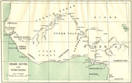
AFRICA. Niger River and Tributaries 1936 old vintage map plan chartJasper524.5(9.9k)See Sold PriceFeb 28, 2024
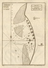
Plan of Portendic… Portu d'Addi or Penia. Portendick Mauritania. LABAT 1745 mapJasper524.5(9.9k)See Sold PriceFeb 28, 2024
FRENCH WEST AFRICA Nigeria Gold Coast Rio de Oro Portuguese Guinea 1912 mapJasper524.5(9.9k)See Sold PriceFeb 28, 2024
Western coast of Africa… to the River Sanaga. Southern Mauritania LABAT 1745 mapJasper524.5(9.9k)See Sold PriceFeb 28, 2024
Colonial Africa North-East. Hejaz Kenya Abyssinia Colonial. THE TIMES 1900 mapJasper524.5(9.9k)See Sold PriceFeb 28, 2024
Afrique Ancienne. Ancient North Africa. MALTE-BRUN c1871 old antique map chartJasper524.5(9.9k)See Sold PriceFeb 28, 2024
Colonial Southern Africa. British Portuguese German. Madagascar. TIMES 1900 mapJasper524.5(9.9k)See Sold PriceFeb 28, 2024
Colonial Africa North-West. British French. Nigeria Sahara. THE TIMES 1900 mapJasper524.5(9.9k)See Sold PriceFeb 28, 2024
Africa by Arrowsmith & Lewis 1812 old antique vintage map plan chartJasper524.5(9.9k)See Sold PriceFeb 28, 2024