ATLAS of ANTIENT GEOGRAPHY by SAMUEL BUTLER 1843John McInnis Auctioneers,LLC4.6(502)See Sold PriceFeb 24, 2024
18TH C. ANTIQUE MAP: FRENCH & INDIAN WAR, FRAMEDThomaston Place Auction Galleries4.4(386)See Sold PriceFeb 24, 2024
Rand McNally Railroad Map Cabinet w/ 21 Railroad MapsRail & Road Auctions4.6(165)See Sold PriceMar 08, 2024
Keith Haring - Ink on New York Map, Best Buddies, Inscribed, Signed, and DatedSapphire Auction Gallery4(67)See Sold PriceMar 02, 2024
LATE 17TH C. FRENCH MAP OF THE NEW WORLD BY ALEXIS-HUBERT JAILLOT (1632-1712)Thomaston Place Auction Galleries4.4(386)See Sold PriceFeb 24, 2024
Central Railroad of New Jersey Map of Sandy Hook Route-ca. 1903JM Hobby Supply and Railroad Artifact Auctions4.4(126)See Sold PriceFeb 24, 2024
Lot of Six Mixed Atlas Box Cars-HO Scale-New in BoxJM Hobby Supply and Railroad Artifact Auctions4.4(126)See Sold PriceFeb 25, 2024
Rand McNally/Santa Fe Railroad Map of Iowa-1912JM Hobby Supply and Railroad Artifact Auctions4.4(126)See Sold PriceFeb 24, 2024
NICOLAES VISSCHER (NETHERLANDS, 1618-1709) MAP OF THE NEW WORLDThomaston Place Auction Galleries4.4(386)See Sold PriceFeb 24, 2024
17TH C. WORLD MAP BY NICOLAES VISSCHER (NETHERLANDS, 1618-1709)Thomaston Place Auction Galleries4.4(386)See Sold PriceFeb 24, 2024
Lot of Six Mixed Atlas Cabooses-HO Scale-New in BoxJM Hobby Supply and Railroad Artifact Auctions4.4(126)See Sold PriceFeb 25, 2024
SoldKlamath Indian Reservation mapsHeading: (Klamath Indians) Author: Title: Letter from the Acting Secretary of the Interior, in Response to Senate resolution of December 13, 1894, transmitting information concerning the survey of thSee Sold Price
Klamath Indian Reservation mapsHeading: (Klamath Indians) Author: Title: Letter from the Acting Secretary of the Interior, in Response to Senate resolution of December 13, 1894, transmitting information concerning the survey of thSee Sold Price
SoldOriginal 1895 Indian Reservation MapThis is an original Native American Indian reservation map from 1895. The map is marked "Map Showing Indian Reservations within the Limits of the United States Compiled Under the Direction of the Hon.See Sold Price
Sold1891 Indian Reservation Map of the United StatesThis is a RARE 1891 map of Indian reservations in the United States. With the Indian Removal Act of 1830, the U.S. Government began moving Native American populations to secluded tracts of land. FromSee Sold Price
SoldMontana Indian Reservation Map Flathead Lake 1939For your consideration is a 1939 former Flathead Indian reservation map from the department of the Interior office of Indian Affairs forestry and grazing division. It was compiled from data obtained fSee Sold Price
Klamath Indian ReservationTitle: Letter from the Acting Secretary of the Interior, in Response to Senate resolution of December 13, 1894, transmitting information concerning the survey of the Klamath Indian Reservation, in OreSee Sold Price
SoldIndian Reservation MapShowing all the Reservations in the United States and Southern Canada - "Tribal Locations in America - Past and Present". Excellent condition, unframed. Circa: Late 1900s Size: 10" x 12"See Sold Price
Sold1889 Indian Reservation Map of the United StatesThis is a RARE 1889 map of Indian reservations in the United States. With the Indian Removal Act of 1830, the U.S. Government began moving Native American populations to secluded tracts of land. FromSee Sold Price
Sold7 folding maps: Indian Reservations (1892)-1920.[Native Americans/Indian Reservation Maps] 7 large folding maps showing locations of Indian reservations. ++ MAP SHOWING THE INDIAN RESERVATIONS WITHIN THE LIMITS OF THE UNITED STATES UNDER THE DIRECTSee Sold Price
Sold1857 DENVER Autograph Letter SignedPolitics on the Klamath Indian Reservation (JAMES WILLIAM DENVER), Mexican War Captain, Commander in Army of the Tennessee, for whom the city of Denver, Colorado is named. Autograph Letter Signed, "H.See Sold Price
1857 Letter to James W. DenverPolitics on the Klamath Indian Reservation (JAMES WILLIAM DENVER), Mexican War Captain, Commander in Army of the Tennessee, for whom the city of Denver, Colorado is named. Autograph Letter Signed, &ldSee Sold Price
SoldOFFICE OF INDIAN AFFAIRS HISTORICAL AMERICAN INDIANOFFICE OF INDIAN AFFAIRS HISTORICAL AMERICAN INDIAN RESERVATIONS MAP, title in circular cartouche to lower right corner "MAP / SHOWING / INDIAN RESERVATIONS / WITHIN THE LIMITS OF THE / UNITED STATESSee Sold Price
Sold1915 Department of Interior US Indian ReservationsFeatured in this lot is this 1915, Department of Interior U.S. Indian Reservations map. The map shows Indian Reservations as of the year 1915 and shows those areas in orange. The map also shows the DeSee Sold Price
SoldWestern Indian Reservations 1880 mapUnknown. Western Indian Reservations 1880. Western Indian Reservations 1880 Compared with reservations of 1840 Printed by BORMAY Eng. CO., NY.. Framed. Medium: Print. Size: 6.5" X 8.5". Signature: UnsSee Sold Price
Sold1904 MAP OF NORTH AMERICA1904 MAP OF NORTH AMERICA 1904 Map of North America. Highlights the major cities for each of the States and other interesting places such as Indian Reservations. Paper map on cloth back with minor weaSee Sold Price
LARGE 1904 WALL MAP OF NORTH AMERICALARGE 1904 WALL MAP OF NORTH AMERICA 1904 Map of North America. Highlights the major cities for each of the States and other interesting places such as Indian Reservations. Paper map on cloth back witSee Sold Price
LARGE 1904 WALL MAP OF NORTH AMERICALARGE 1904 WALL MAP OF NORTH AMERICA 1904 Map of North America. Highlights the major cities for each of the States and other interesting places such as Indian Reservations. Paper map on cloth back witSee Sold Price
LARGE 1904 WALL MAP OF NORTH AMERICALARGE 1904 WALL MAP OF NORTH AMERICA 1904 Map of North America. Highlights the major cities for each of the States and other interesting places such as Indian Reservations. Paper map on cloth back witSee Sold Price
SoldON 2, LARGE FRAMED MAP, INDIAN RESERVATIONS HON.HIRAM PRICE, 1884, PHOTO LITHOGRAPH, BELL BROS, WASHINGTON TOGETHER WITH PHOTO OF CHIEFS, MAP 21" X 33" SIGHT, PHOTO 7 1/2" X 9" SIGHT.See Sold Price
SoldGeneral Thomas Ruger's Cherokee-Arapahoe Land RushGeneral Thomas Ruger's Cherokee-Arapahoe Land Rush Map, two maps of Indian reservations. First is Map of the Cheyenne & Arapahoe Reservation...showing lands to be opened for settlement on April 19,See Sold Price
SoldOil prospectus Blackfeet Indian Reservation in MTTitle: Oil prospector's workbook for the Blackfeet Indian Reservation – containing topographical maps, blueprint maps, and blue line maps of townships Author: ** Description: Approximately 242 pp. WSee Sold Price
Sold1902 map of Indian ReservationsHeading: (United States - Indian Reservations) Author: Title: Map Showing Indian Reservations Within the Limits of the United States, Compiled Under the Direction of Hon. W.A. Jones, Commissioner ofSee Sold Price
SoldManuscript Map of Pyramid Lake NevadaMONROE, Eugene (Surveyor).Map of Pyramid Lake Indian Reservation, Nevada.Manuscript map in pen and ink with original hand color.Nevada, c. 1874 (surveyeed in 1865).23" x 33 1/2" sheet, 32 1/2" x 43" fSee Sold Price
Secretary of Interior report on coal fields in ArizonaOfficial letters to the Secretary of the Interior. Includes one from the Office of Indian Affairs about the character of the coal in the White Mountain Indian Reservation. Cross section map fold out oSee Sold Price
Rand McNally Railroad Map of Washington-1906JM Hobby Supply and Railroad Artifact Auctions4.4(126)See Sold PriceFeb 24, 2024
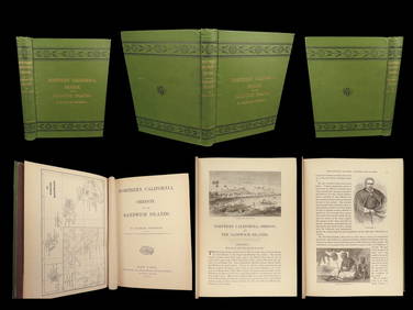
1874 HAWAII 1ed Northern California Oregon Pacific Island Travel Puget RedwoodsSchilb Antiquarian Rare Books4.8(421)See Sold PriceMar 10, 2024
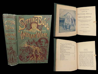
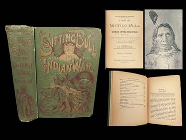
1891 Sitting Bull 1st ed Life Native American Sioux Indians DAKOTA Ghost DanceSchilb Antiquarian Rare Books4.8(421)See Sold PriceMar 10, 2024
18TH C. ANTIQUE MAP: FRENCH & INDIAN WAR, FRAMEDThomaston Place Auction Galleries4.4(386)See Sold PriceFeb 24, 2024
DEVINE c1856 Dr Salters Map Of Lake Huron Ontario Indian Lands etc. No. 7 ScarceLuis Porretta Fine Arts4.3(10)See Sold PriceMar 02, 2024
MATTHEWS c1856 Map Of Upper Canada Ontario Indian Land Agency Divisions Scarce!Luis Porretta Fine Arts4.3(10)See Sold PriceMar 02, 2024
1818 RARE Geography Made Easy MAPS Jedidiah Morse Boston Indians Atlas AsiaSchilb Antiquarian Rare Books4.8(421)See Sold PriceMar 31, 2024
1891 DAKOTA Indians 1st ed Life Sitting Bull Native American Sioux Ghost DanceSchilb Antiquarian Rare Books4.8(421)See Sold PriceMar 31, 2024
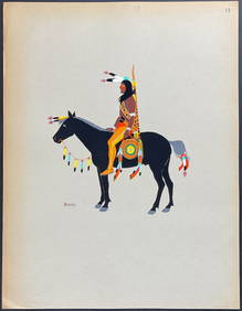
Kiowa Indian Art - Mopope: Kiowa Warrior on HorsebackTrillium Antique Prints & Rare Books4.5(30)See Sold PriceFeb 24, 2024
Kiowa Indian Art - Mopope: Kiowa Warrior and wifeTrillium Antique Prints & Rare Books4.5(30)See Sold PriceFeb 24, 2024
Karl Bodmer - A Young Mandan Indian. 24Trillium Antique Prints & Rare Books4.5(30)See Sold PriceFeb 24, 2024
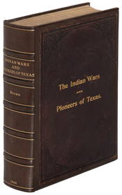
Hist. of Indian wars of the Far West - Massacres of the MountainsJasper524.5(9.8k)See Sold PriceFeb 27, 2024
Carte du Canal de Mosambique…. Madagascar Bonne Esperance. BONNE 1780 mapJasper524.5(9.8k)See Sold PriceFeb 28, 2024
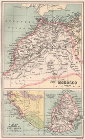
MOROCCO LIBERIA & MAURITIUS. Sierra Leone. BARTHOLOMEW 1886 old antique mapJasper524.5(9.8k)See Sold PriceFeb 28, 2024
Blackie (Pub) 1882 Folio Map. East Indies - Indian ArchipelagoAlbion Auctions4.6(336)See Sold PriceMar 01, 2024
A LARGE ERRATA BOOK INDIAN MAPS AND STUDIES including the provinces of Bengal, Cossimbuzar Island, THannam's Auctioneers Ltd4.3(386)See Sold PriceFeb 27, 2024