SoldMAP OF CHARLESTON AND HARBOR DATED 1880Dimensions: (Frame) H 34.25" x W 26.25", (Sight) H 25" x W 19.5" Condition: Creases and toning to paper.See Sold Price
MAP OF CHARLESTON AND HARBOR DATED 1880Dimensions: (Frame) H 34.25" x W 26.25", (Sight) H 25" x W 19.5" Condition: Creases and toning to paper.See Sold Price
SoldFramed Map, HarpersvWeekly Page, 18619.5 x 9 inch framed map Charleston Harbor dated 1841?, framed page from Harpers Weekly, 1861 showing city of Charleston looking seawardSee Sold Price
SoldRare and early Colonial Charleston South CarolinaRare and early Colonial Charleston South Carolina map dated 1776BARRE ET DU HAVRE CHARLES-TOWN (Charles-Town Bar and Harbor) illustrating various significant locations including: Charlestowne, SavagesSee Sold Price
SoldRevolutionary map, Charleston Harbor,"A Birds Eye View from part of Mount Pleasant…" by William Faden (1750-1836), London, 1776, showing panoramic view of islands in Charleston Harbor including fortifications, encampments, and a legendSee Sold Price
SoldUS GEOLOGICAL MAP CHARLESTON HARBOR APPROACHESLARGE US GEOLOGICAL SURVEY MAP CHARLESTON HARBOR APPROACHESSee Sold Price
Sold1858 US Coast Survey Map of Charleston Harbor --Title/Content of Map: 1858 US Coast Survey Map of Charleston Harbor -- Preliminary Chart of Charleston Harbor and Its Approaches from a Trigonometrical Survey Under the Direction of A.D. Bache… CartSee Sold Price
SoldMap of Charleston Harbor S. C.Reserve Reduced! Title/Content of Map: Map of Charleston Harbor S. C. Date: 1860 Cartographer: Gratiot, C. et al. Publisher: American State Papers Size: 17.5 x 22.5 inches Large map from "The ConstrucSee Sold Price
SoldLarge Framed Map of Charleston HarborLarge framed map of Charleston Harbor. Approx. 36 inches x 50 inches. Overall good condition.See Sold Price
Sold1858 Chart Map of Charleston Harbor"Preliminary Chart of Charleston Harbor And Its Approaches From a Trigonometric Survey . . . Triangulation by C.O. Boutelle . . . Topography by S.A. Gilbert & J. Seib . . . Hydrography by the PartiesSee Sold Price
SoldMap of Charleston Harbor, Showing Fort Sumter and theTitle: Map of Charleston Harbor, Showing Fort Sumter and the Confederate Batteries. Date: 1861-04-27 Cartographer: ANONYMOUS Size: 9.25 X 13.8 Please note that this lot has a confidential reserve. WheSee Sold Price
SoldRare and Imposing 1825 Map of Charleston HarborCharleston Harbour and the adjacent coast and country, South Carolina: surveyed at intervals in 1823, 1824, and 1825, drawn by Hartman Bache, James Duncan Graham, Constant M. Eakin, William M. Boyce,See Sold Price
SoldBowen & Co. Map of Charleston Harbor S.C.Bowen & Co. Map of Charleston Harbor S.C. American, ca. 1860. View of Charleston Harbor describing water depths. Includes Forts Johnson, Sumter, Moultrie, and Castle Pinckney with lines showing the raSee Sold Price
1858 US Coast Survey Map of Charleston Harbor --Title/Content of Map: 1858 US Coast Survey Map of Charleston Harbor -- Preliminary Chart of Charleston Harbor and Its Approaches from a Trigonometrical Survey Under the Direction of A.D. Bache… DateSee Sold Price
1858 US Coast Survey Map of Charleston Harbor --Title/Content of Map: 1858 US Coast Survey Map of Charleston Harbor -- Preliminary Chart of Charleston Harbor and Its Approaches from a Trigonometrical Survey Under the Direction of A.D. Bache… CartSee Sold Price
1858 US Coast Survey Map of Charleston Harbor --Title/Content of Map: 1858 US Coast Survey Map of Charleston Harbor -- Preliminary Chart of Charleston Harbor and Its Approaches from a Trigonometrical Survey Under the Direction of A.D. Bache… DateSee Sold Price
1858 US Coast Survey Map of Charleston Harbor --Title/Content of Map: 1858 US Coast Survey Map of Charleston Harbor -- Preliminary Chart of Charleston Harbor and Its Approaches from a Trigonometrical Survey Under the Direction of A.D. Bache… DateSee Sold Price
1858 US Coast Survey Map of Charleston Harbor --Title/Content of Map: 1858 US Coast Survey Map of Charleston Harbor -- Preliminary Chart of Charleston Harbor and Its Approaches from a Trigonometrical Survey Under the Direction of A.D. Bache… DateSee Sold Price
1858 US Coast Survey Map of Charleston Harbor --Title/Content of Map: 1858 US Coast Survey Map of Charleston Harbor -- Preliminary Chart of Charleston Harbor and Its Approaches from a Trigonometrical Survey Under the Direction of A.D. Bache… DateSee Sold Price
1858 US Coast Survey Map of Charleston Harbor --Title: 1858 US Coast Survey Map of Charleston Harbor -- Preliminary Chart of Charleston Harbor and Its Approaches from a Trigonometrical Survey Under the Direction of A.D. Bache… Cartographer: US CoSee Sold Price
Original Map Engraving Charleston Harbor 1806Navigations. All original. Not a reproduction. Image is 7 1/2 x 4 inches. In a 17 x 15 inch frame.See Sold Price
Sold1867 NORTH + SOUTH CAROLINA MAPOriginal antique map of North and South Carolina published by S. Augustus Mitchell, Jr. Includes inset maps of Charleston Harbor in the bottom left and a Plan of Charleston in the bottom right. It feaSee Sold Price
Sold1886 Map of CharlestonAuthor: Cram Title: 1886 Map of Charleston Medium: Ink on Paper Dimensions: 11"X14.5" Map of Charleston dated 1886. Engraved and printed by George Cram in Chicago. Out of all the city maps, CharlestonSee Sold Price
SoldCharleston Harbor, Civil War-Date Map Owned byCharleston Harbor, Civil War-Date Map Owned by Confederate Engineer Col. David B. Harris, Plus Lot of 2, featuring a hand-tinted map of Charleston Harbor accompanied by a hand-tinted albumen print oSee Sold Price
Cleveland and Mahoning RR 2nd Annual Report-December 20, 1854JM Hobby Supply and Railroad Artifact Auctions4.4(126)See Sold PriceFeb 24, 2024
Rand McNally Railroad Map of Colorado-1929JM Hobby Supply and Railroad Artifact Auctions4.4(126)See Sold PriceFeb 24, 2024
Rand McNally Township County and Railroad Map of Illinois-1879JM Hobby Supply and Railroad Artifact Auctions4.4(126)See Sold PriceFeb 24, 2024
Rand McNally Township County and Railroad Map of Indiana-1880JM Hobby Supply and Railroad Artifact Auctions4.4(126)See Sold PriceFeb 24, 2024
Rand McNally/Santa Fe Railroad Map of Iowa-1912JM Hobby Supply and Railroad Artifact Auctions4.4(126)See Sold PriceFeb 24, 2024
Chicago and Northwestern RY Travelers Companion Notebook-1880JM Hobby Supply and Railroad Artifact Auctions4.4(126)See Sold PriceFeb 24, 2024
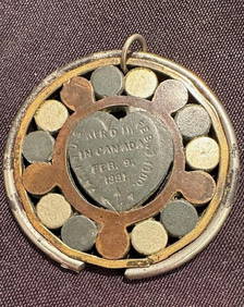
Richardson's Medical Quackery Magentic Galvantic Canadian 1881 BatteryCowboy Joe's Antiques4.7(196)See Sold PriceFeb 27, 2024
19th Century Gold & Organic Swagger / Pointer StickHeritage Gallery Auctions4.4(56)See Sold PriceMar 10, 2024
Vintage Vanguard Studio wall map, dated 1968South Jersey Auction by Babington Auction Inc4.6(123)See Sold PriceFeb 25, 2024
German 19C. Antique Meerschaum Pipe & Leather CaseHill Auction Gallery 4.7(1k)See Sold PriceFeb 28, 2024
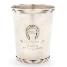
A Kentucky Derby Commemorative Sterling Silver Julep CupLeland Little4.5(697)See Sold PriceFeb 29, 2024
BRITISH SCHOOL, OIL ON CANVAS, RIVERSCAPE,Pridham's Auctions & Appraisals4.7(223)See Sold PriceMar 02, 2024
ANTIQUE HUNGARIAN ZSOLNAY PORCELAIN TABLEWARE SETAntique Arena Inc.4.5(866)See Sold PriceMar 09, 2024
Tray 3 19th C Glasses 1 Dated 1880 W/Etched Cathedral Etched + Cut W/ 3 Bouquets, 1 Pressed +George Cole Auctions4.5(391)See Sold PriceMar 02, 2024