SoldMap, Scotland, after Mercator, Isle Skye, HebridesFramed double-sided engraved and handcolored map, Scotiae Regnum (Southern section including the Isle of Skye and the Southern Hebrides), after Gerardus Mercator (Flemish, 1512-1594), text verso beginSee Sold Price
SoldOrdnance Survey maps,West Coast of Scotland, late 19th century with some revisions, approx 60 sheets, some with vignettes, including Lochs, Western Isles, Skye, Harris, Hebrides etc, condition varies (c.60)See Sold Price
SoldCollection of Continental Maps and Other Items ofCollection of Continental maps including many maps of Scotland, Isle of Skye, London, Brighton, Chatham, Margate, and Hastings as well as a book of Elizabethan Miniatures, "The Sad Shepherd" Henry VanSee Sold Price
SoldMap, after Mercator, Scotland, Okneys, HebridesFramed double-sided engraved and handcolored map, ''Scotiae Regnum'' (Northern section including the Orkney Islands and the Hebrides), after Gerardus Mercator (Flemish, 1512-1594), text verso beginninSee Sold Price
SoldFour 17th Century British Isles Maps,Four 17th Century British Isles Maps, all ca. 1650s, as follows: "Aebudae Insulae Sive Hebrides...The Western Isles of Scotland," Timothy Pont, published by Joan Blau, Amsterdam, (SS:15" x 21"); "EpisSee Sold Price
SoldMacdonald (James)Macdonald (James) General View of the Agriculture of the Hebrides, or Western Isles of Scotland, first edition, engraved plate and 5 folding maps, lacking frontispiece, some foxing and spottinSee Sold Price
SoldMacdonald (James)Macdonald (James) General View of the Agriculture of the Hebrides, or Western Isles of Scotland, first edition, engraved plate and 5 folding maps, some foxing and spotting (heavy in places), lSee Sold Price
SoldMercator (Gerard) 3 maps of ScotlandMercator (Gerard) Scotia Regnum,Scotland, with the Orkneys and Hebrides, and the north coast of Ireland, with large strapwork cartouche, upper right, engraved map, 350 x 400mm., French text veSee Sold Price
SCOTLAND ISLANDS. Western Isles. Orkneys, Shetlands andTITLE/CONTENT OF MAP: 'SCOTLAND, III., Islands - Orkneys, Shetlands and Hebrides' DATE PRINTED: 1874 IMAGE SIZE: Approx 40.5 x 34.0cm, 16 x 13.25 inches (Large) TYPE: Antique steel engraved map with oSee Sold Price
SCOTLAND ISLANDS. Western Isles. Orkneys, Shetlands andTITLE/CONTENT OF MAP: 'SCOTLAND, III., Islands - Orkneys, Shetlands and Hebrides' The top image on the right hand side shows the entire map. To view a close up of the map showing the level of printedSee Sold Price
Sold17th Century Map of Northern ScotlandMap titled "Isle De Fero de Scheland Orknay et Hebrides" by Alain Manesson Mallet, Frankfurt ,1686. Framed map measures 5.75" x 4.25" (sight). Map exhibits extensive hand coloring. Frame measuresSee Sold Price
MERCATOR [Gerard] Scotiae regnum. 36 x 46MERCATOR [Gerard] Scotiae regnum. 36 x 46 cms. Black wood frame. Hand coloured map of Northern Scotland and the Isles. ? Amsterdam, c. 1640s.See Sold Price
SoldGerard Mercator, (2) 16th c. maps of British IslesGerard Mercator, (2) 16th c. maps of British Isles, Gerard Mercator (German, 1512-1594), half sheets of Scotland and England, c. 1580s, 19.5"h x 22.5"w (sheet), unframed Provenance: Property from a maSee Sold Price
SoldMercator Hondius. Southern ScotlandMercator (Gerard) and Henricus Hondius. La Partie Meridionale de l'Ecosse,southern Scotland, the Hebrides and northern Ireland, engraved map with full hand-colouring, 350 x 455mm., French textSee Sold Price
SoldMercator (G) ScotiaMercator (Gerard) Tab. III Scotiae, Scotland and the Hebrides, engraved map with original outline hand-colouring, 345 x 455mm., central vertical fold, slight splitting at foot, Latin text on vSee Sold Price
SoldMercator (Gerard) Scotiae RegnumMercator (Gerard) Scotiae Regnum, engraved map of the north of Scotland, the Orkneys, and the Hebrides, with original outline hand-colouring, ornamental cartouche, 355 x 460mm., French text oSee Sold Price
SoldMap, Gerhard MercatorGerhard Mercator (Flemish, 1512-1594), Scotiae, Scotland and the Hebrides, copper engraved map with hand coloring, overall (with frame): 22"h x 25.25"w. Note: exact printing date is unknown.See Sold Price
SoldMercator (Gerard) Scotiae RegnumMercator (Gerard) Scotiae Regnum,north and south Scotland, the Orkneys and the Hebrides, with strapwork title cartouche on northern sheet, 2 engraved map sheets, with original hand-colouring,See Sold Price
SoldMercator (Gerard) Scotiae RegnumMercator (Gerard) Scotiae Regnum,north and south Scotland, the Orkneys and the Hebrides, with strapwork title cartouche on northern sheet, 2 engraved map sheets, with original hand-colouring,See Sold Price
SoldScotland - Isle of SkyeSchmid, Richard, (1934- ), 14 x 22 inches, oil on canvas, signed lower rightSee Sold Price
SoldTWO 18TH CENTURY MAPS - SALZBURG, ISLE OF SKYEIncludes Johann Baptist Homann's undated 'Salisburgensis,' 19 x 22.5 inch sight size, 25 x 28.5 inch frame. Hand tinted, some tearing at edges, and stain to middle left edge. Homann was perhaps the moSee Sold Price
SoldCowperthwait: Map of Scotland & Shetland Isles, 1850Map of Scotland & Shetland Isles. Original engraving by Thomas Cowperthwait, circa 1850. Inset includes Shetland Isles. Beautiful original color. Dimensions 14" x 17". Please note that this lot has aSee Sold Price
Isle of Skye. Inverness-shire part. Lochalsh Rum EigTITLE/CONTENT OF MAP: 'Skye Island &c. Part of Inverness-shire' Places named on the map include: Isle of Skye, Lochalsh, Portree, Applecross, Rum, Eig, Mallaig, Talisker The top image on the right hanSee Sold Price
SoldScotland. North sheet. Highlands and Islands. SIDNEYTITLE/CONTENT OF MAP: 'Scotland [inset: Orkney Isles] [North sheet]' DATE: c1845 IMAGE SIZE: Approx 43.0 x 57.5cm, 17 x 22.75 inches (Large); Please note that this is a folding map. TYPE: Antique atlaSee Sold Price
LATE 16TH C. MAP OF SCOTLAND BY MERCATOR, FRAMEDThomaston Place Auction Galleries4.4(386)See Sold PriceFeb 24, 2024
Chatelain - 3 Maps of the British Isles (England, Ireland, Scotland)Trillium Antique Prints & Rare Books4.5(30)See Sold PriceFeb 24, 2024
De Jode, Rare, pub. 1593 - Map of the British Isles [England, Scotland, Ireland] (Angliae Scotiae etTrillium Antique Prints & Rare Books4.5(30)See Sold PriceFeb 24, 2024
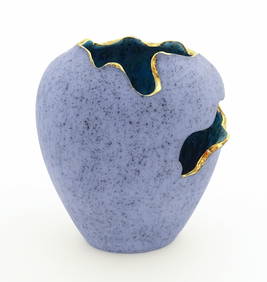
A modern Scottish studio pottery Torn Pot vase by Carbostcraft Pottery, Isle of Skye. Designed byClaydon Auctioneers Ltd4.3(125)See Sold PriceFeb 25, 2024
Map: A 17thC engraved and hand coloured map of Scotland titled Strath-Navernia / Strath Navern afterClaydon Auctioneers Ltd4.3(125)See Sold PriceFeb 26, 2024
Blackie (Pub) 1882 Folio Map. World on Mercators ProjectionAlbion Auctions4.6(336)See Sold PriceMar 01, 2024
Paterson & Mogg 1822 Pair of British Road Maps. Isle of Thanet & WightAlbion Auctions4.6(336)See Sold PriceMar 01, 2024
Isle of Skye-21 year old (1) Grand Slam Dram-10 year old (4) Famous Grouse Vintage Malt Whisky...Bonhams4.1(305)See Sold PriceFeb 26, 2024


![De Jode, Rare, pub. 1593 - Map of the British Isles [England, Scotland, Ireland] (Angliae Scotiae et (1 of 2)](https://p1.liveauctioneers.com/6581/319571/171593327_1_x.jpg?height=282&quality=70&version=1707853304)