ATLAS of ANTIENT GEOGRAPHY by SAMUEL BUTLER 1843John McInnis Auctioneers,LLC4.6(502)See Sold PriceFeb 24, 2024
18TH C. ANTIQUE MAP: FRENCH & INDIAN WAR, FRAMEDThomaston Place Auction Galleries4.4(386)See Sold PriceFeb 24, 2024
Rand McNally Railroad Map Cabinet w/ 21 Railroad MapsRail & Road Auctions4.6(165)See Sold PriceMar 08, 2024
Keith Haring - Ink on New York Map, Best Buddies, Inscribed, Signed, and DatedSapphire Auction Gallery4(67)See Sold PriceMar 02, 2024
LATE 17TH C. FRENCH MAP OF THE NEW WORLD BY ALEXIS-HUBERT JAILLOT (1632-1712)Thomaston Place Auction Galleries4.4(386)See Sold PriceFeb 24, 2024
Central Railroad of New Jersey Map of Sandy Hook Route-ca. 1903JM Hobby Supply and Railroad Artifact Auctions4.4(126)See Sold PriceFeb 24, 2024
Lot of Six Mixed Atlas Box Cars-HO Scale-New in BoxJM Hobby Supply and Railroad Artifact Auctions4.4(126)See Sold PriceFeb 25, 2024
Rand McNally/Santa Fe Railroad Map of Iowa-1912JM Hobby Supply and Railroad Artifact Auctions4.4(126)See Sold PriceFeb 24, 2024
NICOLAES VISSCHER (NETHERLANDS, 1618-1709) MAP OF THE NEW WORLDThomaston Place Auction Galleries4.4(386)See Sold PriceFeb 24, 2024
17TH C. WORLD MAP BY NICOLAES VISSCHER (NETHERLANDS, 1618-1709)Thomaston Place Auction Galleries4.4(386)See Sold PriceFeb 24, 2024
Lot of Six Mixed Atlas Cabooses-HO Scale-New in BoxJM Hobby Supply and Railroad Artifact Auctions4.4(126)See Sold PriceFeb 25, 2024
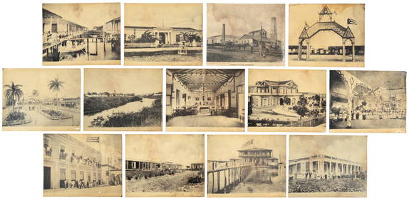
Cuba – Map of Cuba, it's Provinces, Railroads...Cuba – Map of Cuba, it's Provinces, Railroads, Cities, Towns, Harbours, Bays etc. – by Mast Crowell and Kirkpatrick, in colour, measures 51x35cm approx., folds in places o/w a good exampleSee Sold Price
Cuba – Map of Cuba, it’s Provinces, Railroads...Cuba – Map of Cuba, it's Provinces, Railroads, Cities, Towns, Harbours, Bays etc. – by Mast Crowell and Kirkpatrick, in colour, measures 51x35cm approx., folds in places o/w a good exampleSee Sold Price
Rand-McNally: Antique Cuba Railroads Map, 1901Cuba. A meticulously detailed map of the island showing 18 railroad lines, all station stops, clear topography, and countless towns and place names, with inset plans of Havana Harbor, Port Matanzas, CSee Sold Price
Cuba, S. Augustus Mitchell, 1873A beautiful example of S. A. Mitchell Jr.'s 1872 map of Cuba. Shows cities, towns, railroads and roadways with color coding according to district. Also includes the Great Bahama Bank and many of the BSee Sold Price
Mitchell: Antique Map of Cuba, 1873A beautiful example of S. A. Mitchell Jr.'s 1872 map of Cuba. Shows cities, towns, railroads and roadways with color coding according to district. Also includes the Great Bahama Bank and many of the BSee Sold Price
Cuba Map, George Cram, 1906Cuba. George Cram. Cram's Unrivaled Family Atlas of the World Indexed. 1906. 22 x 14.5. Inset showing Province of Habana Please note that this lot has a confidential reserve. When you leave a bid in aSee Sold Price
Cuba Map, Rand-McNally, 1901Cuba Map. A meticulously detailed map of the island showing 18 railroad lines, all station stops, clear topography, and countless towns and place names, with inset plans of Havana Harbor, Port MatanzaSee Sold Price
Cuba Part of Chart "E" 1898Map: Cuba Part of Chart "E" Maker: U.S. Coast and Geodetic Survey Publishing: Washington DC 1898 Size: 16.5 x 41 inches Detailed topographic map showing roads and railroads, all towns. Excellent largeSee Sold Price
SoldCram: Map of Cuba, Jamaica and San Domingo 1895Title/Content of Map: Cuba, Jamaica and San Domingo Date Printed: 1895 Cartographer: CRAM, GEORGE F. Size (inches): 16X22.1 From Grant's Railroad & Business atlas.Large map with nautical distances andSee Sold Price
SoldRand-McNally: Cuba Railroads MapMap: Cuba Cartographer:Rand-McNally Place/Date: Chicago / 1901 Size: 19 1/2 x 12 3/8" Condition: full-color lithograph; overall age toning evident mostly in the margins A meticulously detailed map ofSee Sold Price
Robiquet: Antique Map Gulf of Mexico & Caribbean, 1853Title: Carte Generale des Iles Antilles et du Golfe du Mexique Dressee d'Apres les Travaux Anglais et Espagnols. Large French sea chart of the Gulf of Mexico and Caribbean, centered on Cuba Map maker:See Sold Price
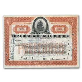
SoldCuba Railroad Co., $1000 bond, 1902 vignette of oCuba, Cuba Railroad Co., $1000 bond, 1902 vignette of oncoming train, black and orange, $1000 bond 1910, vignette of taain passing through station, black & green, also Banco Territorial de CubSee Sold Price
SoldCuba Railroad Co., incorporated U.S.A., $1,000 goCuba Cuba Railroad Co., incorporated U.S.A., $1,000 gold bond, 1910, vignette of passenger train by station, signed by W.C. Van Horne as president, very clear signature, black & green with couSee Sold Price
SoldMercator / Hondius: Antique Map Cuba / Hispaniola, 1607Title/Content of Map: Cuba Insul/Hispaniola Cartographer: Mercator / Hondius Place & Date: Amsterdam / 1607/1620s Size: 7 1/8" x 5 5/8" Condition: full color; overall age-toning and some staining; resSee Sold Price
SoldBonne: L'Isle de Cuba Map, 1760L'Isle de Cuba Map. M. Bonne, C. 1760 Paris. Professional repair to tear on right margin, not into image. Overall good condition, full sheet. Please note that this lot has a confidential reserve. WhenSee Sold Price
SoldCuba Map, Porcacchi, 1572Cuba Map. Porcacchi's well-known map of Cuba (with Jamaica and part of Hispaniola), from his 1572 Isolario, The World's Most Famous Islands. A delightful cartouche, a compass rose and fanciful marineSee Sold Price
SoldMap, Cuba Insula Hispaniola I.S. Margareta CumMap, Cuba Insula [with] Hispaniola Insula [with] Insula Jamaica [with] Ins. S. Ioannis [with] I.S. Margareta Cum Confiniis, on cardboard, map is 17.25" by 21.75". All items sold as is, all sales finalSee Sold Price
SoldAntique Map - Cuba & The Bahama Islands - 1889Antique Map - Cuba & The Bahama Islands - 1889 from Cram's Atlas 1889. Size : 14.5" x 11"See Sold Price
Antique Map - Cuba & The Bahama Islands - 1889Antique Map - Cuba & The Bahama Islands - 1889 from Cram's Atlas 1889. Size : 14.5" x 11"See Sold Price
MAP, Cuba, BonneCuba. Rigobert Bonne, L'Isle de Cuba, from Atlas de Toutes les Parties Connues du Globe Terrestre, 1780 (circa). Hand Color. Attractive copperplate engraving of Cuba and the Bahamas. It is geographicaSee Sold Price
SoldGross, Alexander 1920 Pair of LG Maps. Cuba & Jamaica"Cuba and Jamaica" and "West Indies" also showing Cuba and Jamaica. Large Lithograph Maps Published 1920, London for "The Daily Telegraph Victory Atlas of the World" by Alexander Gross. Centre fold asSee Sold Price
SoldMANILA & SANTIAGO DE CUBA, MAPS DURING WAR, 3MANILA & SANTIAGO DE CUBA, MAPS DURING SPANISH AMERICAN WAR, THREE, H 18" - 24", W 18" - 30":depicts military maps of the battle areas of Santiago, Cuba and Manila, Philippines during the Spanish AmerSee Sold Price
SoldCuba The Cuba Railroad Co. Quartet.1902-51. $10,000. 4 different certificates, 2 are unlisted Specimen Registered Bonds and 2 are Certificate of deposit stocks. 1). Cuba Railroad Co. $10,000. Brown border. Train in oval. 1st Mortgage 5See Sold Price
SoldTwo small 19th Century maps, Cuba and the UnitedTwo small 19th Century maps, Cuba and the United States, the latter published by Thomas Kelly, drawn and engraved by Alexander FindlaySee Sold Price
The Cuba Railroad Company Stock Certificate (Van Horne)Golden Air Auctions4.4(257)See Sold PriceFeb 27, 2024