ATLAS of ANTIENT GEOGRAPHY by SAMUEL BUTLER 1843John McInnis Auctioneers,LLC4.5(505)See Sold PriceFeb 24, 2024
18TH C. ANTIQUE MAP: FRENCH & INDIAN WAR, FRAMEDThomaston Place Auction Galleries4.4(394)See Sold PriceFeb 24, 2024
Rand McNally Railroad Map Cabinet w/ 21 Railroad MapsRail & Road Auctions4.6(165)See Sold PriceMar 08, 2024
Keith Haring - Ink on New York Map, Best Buddies, Inscribed, Signed, and DatedSapphire Auction Gallery4.1(67)See Sold PriceMar 02, 2024
LATE 17TH C. FRENCH MAP OF THE NEW WORLD BY ALEXIS-HUBERT JAILLOT (1632-1712)Thomaston Place Auction Galleries4.4(394)See Sold PriceFeb 24, 2024
Central Railroad of New Jersey Map of Sandy Hook Route-ca. 1903JM Hobby Supply and Railroad Artifact Auctions4.4(127)See Sold PriceFeb 24, 2024
Lot of Six Mixed Atlas Box Cars-HO Scale-New in BoxJM Hobby Supply and Railroad Artifact Auctions4.4(127)See Sold PriceFeb 25, 2024
Rand McNally/Santa Fe Railroad Map of Iowa-1912JM Hobby Supply and Railroad Artifact Auctions4.4(127)See Sold PriceFeb 24, 2024
NICOLAES VISSCHER (NETHERLANDS, 1618-1709) MAP OF THE NEW WORLDThomaston Place Auction Galleries4.4(394)See Sold PriceFeb 24, 2024
17TH C. WORLD MAP BY NICOLAES VISSCHER (NETHERLANDS, 1618-1709)Thomaston Place Auction Galleries4.4(394)See Sold PriceFeb 24, 2024
Lot of Six Mixed Atlas Cabooses-HO Scale-New in BoxJM Hobby Supply and Railroad Artifact Auctions4.4(127)See Sold PriceFeb 25, 2024
SoldAn 18th Century Map of the Polish Empire, ExtendingHenri Abraham Chatelain (1684-1743), Paris 1712, title reads 'Carte De Pologne Avec La Chronologie Des Rois Et Des Ducs De Lithuanie, Ainsi Que Des Grands Maitres De L'Ordre Teutonique Les Evechez etSee Sold Price
SoldAn 18th Century Detailed map of the Polish Empire,John Senex, Published London, c.1719, cartouche reads 'Poland and other the Countries belonging to the Crowne According to the Newest Observation 1719' Note: This, the second edition of the map, whichSee Sold Price
SoldA 18th Century Map of Poland Extending to Lithuania &Published c. 1703, Guillaume De L'Isle (1675-1726), cartouch reads 'La Pologne Dressee sur ce qu'en ont donne Starovolsk, Beauplan, Hartnoch…', detailed map of Poland at the beginning of the 18tSee Sold Price
A late 18th Century Map of the Empire of Germany byincluding all the states comprehended under that name: with the Kingdom of Prussia, &c. (Northern section). By L. Delarochette. London, printed for Robt. Sayer, Map & Print Seller, opposite Fetter LanSee Sold Price
SoldLate 18th Century American Map of Georgia Extending toLate 18th Century American Map of Georgia Extending to Mississippicopperplate engraving without color, likely published in Philadelphia, between Tennessee's admission to the Union in 1796 and MississiSee Sold Price
SoldTHREE 18TH CENTURY MAPS OF THE RUSSIAN EMPIRETHREE 18TH CENTURY MAPS OF THE RUSSIAN EMPIRE. Comprising three maps of Russia including a 1739 Hase and Homann Heirs Map of Russia and Asia. The map with colored regions of Russia and two cartouchesSee Sold Price
18th Century Map of the Persian EmpireMap of the Persian Empire: "Regnum persicum imperium turcicum in asia…". Hand-colored copperplate engraving. The map shows the Kingdom of Persia, Ottoman Anatolia, Russia, the Caspian Sea and thSee Sold Price
SoldSenex's Map of The English EmpireAn early 18th century map of "The English Empire in America...". By John Senex, published 1719. Hand colored engraving on paper. Slight discoloration and fading, center creases, not examined out of frSee Sold Price
SoldTwo 18th century maps of GermanyTwo 18th century maps of Germany: "The Empire of Germany with the 13 Cantons of Switzerland…," published 1785 by Robinson, London, fold creases, color bleeding from other pages, 18-1/2 x 17"; GermanSee Sold Price
"Carte de l'Empire de Perse". Iran & Caucasus. SANTINITITLE/CONTENT OF MAP: 'Carte de l'Empire de Perse dressée sur les Cartes du Sr. d'Anville. À Venise par P. Santini 1779. Chez Mr. Remondini [Map of the Persian Empire]' A decorative 18th century mapSee Sold Price
Sold18TH CENTURY H. MOLL IMPERIUM ROMANUM MAP18TH CENTURY H. MOLL IMPERIUM ROMANUM MAP: ''Imerium Romanum'' by Herman Moll, early to mid-18th century publication. Map depicts spread of the Roman empire with inset titled ''Maris Inferi Seu TyrrheSee Sold Price
18TH CENTURY H. MOLL IMPERIUM ROMANUM MAP18TH CENTURY H. MOLL IMPERIUM ROMANUM MAP: "Imerium Romanum" by Herman Moll, early to mid 18th century publication. Map depicts spread of the Roman empire with inset titled "Maris Inferi Seu TyrrheniSee Sold Price
Sold18TH CENTURY MAP OF SOUTHERN US & SPANISH FLORIDAPrinted map of the early US-Spanish border in the south. It shows US states of Virginia, North Carolina and Georgia extending all the way to the Mississippi River. Also portrays the borders of East anSee Sold Price
Sold18TH CENTURY MAP OF SOUTHERN US & SPANISH FLORIDAPrinted map of the early US-Spanish border in the south. It shows US states of Virginia, North Carolina and Georgia extending all the way to the Mississippi River. Also portrays the borders of East anSee Sold Price
SoldA Late 18th Century Map of The European Part of thelate 18th Century map of "The European Part of the Russian Empire, The Asiatic Part of the Russian Empire", publ Robert Sayer, London 1st May 1790; engraved map with hand-colouring, from the maps publSee Sold Price
Sold18TH CENTURY MAP OF NORTH AMERICA18TH CENTURY MAP OF NORTH AMERICA: Titled "A New Map of North America", no visible printer or cartographer name. Map shows the entire east coast, extending into Louisiana to the west, Newfoundland toSee Sold Price
Sold18th Century Map of North AmericaMap titled "A map of the British Empire in North America" by Samuel Dunn, published by Robert Sayer, London, 1774. Plate measures 19.25" x 12.25" on sheet measuring 21.5" x 15". Map presents hand-coloSee Sold Price
SoldA Late 18th Century Map of The European Part of thelate 18th Century map of "The European Part of the Russian Empire, The Asiatic Part of the Russian Empire", publ Robert Sayer, London 1st May 1790; engraved map with hand-colouring, from the maps publSee Sold Price
Sold18TH CENTURY MAP OF RUSSIA BY EMAN BOWEN(1714-1767):Antique map of the Russian Empire. Emanuel Bowen was a print and map seller by trade, he was also engraver to both George II and Louis XV of France. From 1714 onwards he worked in London and began toSee Sold Price
Maps circa 1750 Ottoman empire by Thomas Bowen & anMaps circa 1750 Ottoman empire by Thomas Bowen & an 18th century map of Asia.See Sold Price
18TH CENTURY MAP OF PANNONIA18TH CENTURY MAP OF PANNONIA: 18th century engraved map of Pannonia, which was under the Roman Empire. Sight size Approx. 8.75" h x 12.25" w. Framed Approx. 17.25" h x 21.25" w. Estate of Dr. Peter J.See Sold Price
Sold18th century map of Southwest PacificMap titled "2 Partie De La Nouvelle Grande Carte Des Indes Orientales, Contenant Les Empires De La Chine & Du Japon…". This is sheet 2 of Elwe's Southeast Asia in four sheets, depicting China, JapanSee Sold Price
SoldGrp: 5 Maps of Germany Europe and the MediterraneGroup of five 18th century maps. This group includes a hand colored map of Germany by Herman Moll (ca. 1654-1732); one map of the Turkish empire by Tobias Conrad Lotter (1717-1777); one map of the BriSee Sold Price
LARGE 18TH C MAP OF RUSSIAA FINE 18TH CENTURY MAP OF RUSSIA, 1750, ROBERT DE VAUGONDY. Partie Occidentale DE L'EMPIRE DE RUSSIE A finely engraved map with large title cartouche upper left dated 1750, original hand-colorinSee Sold Price
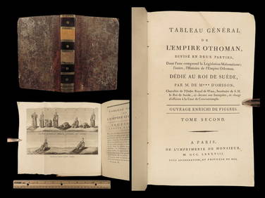
1788 1ed Ottoman Empire MUSLIM Muezzin PRAYER Sultan Selim II TURKS dOhssonSchilb Antiquarian Rare Books4.8(431)See Sold PriceMar 10, 2024
Lot of 13 watercolors and drawings. 18th/19th centuries. To include Empire period portraits,Tremont Auctions4.5(298)See Sold PriceFeb 25, 2024
Empire by Buccellati Italy Sterling Silver Flatware Set 99 pieces DinnerBidhaus4.3(773)See Sold PriceFeb 25, 2024
An early Dutch hand colored engraving map by Georg Balthasar Probst (1732-1801)Ostantix Auctions4.4(11)See Sold PriceFeb 27, 2024
CONGO HEMBA TRIBE RARE FETISH FEMALE FIGURE. WOOD 1,6 kgArs Coin Wien4.5(42)See Sold PriceFeb 25, 2024
18th Century Hess Germany Hand colored Engraved MapGlobal Auctions Company4.3(36)See Sold PriceMar 03, 2024
18th century MAP of ARMENIA GEORGIA NATOLIA BLACK SEA ASIA MINOR antiqueJasper524.5(9.9k)See Sold PriceFeb 27, 2024
La Basse-Guinée… Loango, Congo, AngoIa & Benguela Southern Africa BONNE 1790 mapJasper524.5(9.9k)See Sold PriceFeb 28, 2024
États du Roi de Maroc… d’Alger, Tunis & Tripoli. North Africa. BONNE 1790 mapJasper524.5(9.9k)See Sold PriceFeb 28, 2024
Le Canal de Mosambique, l'Isle de Madagascar… Mozambique. Africa. BONNE 1788 mapJasper524.5(9.9k)See Sold PriceFeb 28, 2024
Royaumes, Etats et Pays de la Haute Guinée. Gulf of Guinea. BONNE 1788 old mapJasper524.5(9.9k)See Sold PriceFeb 28, 2024
La Nubia ed Abissinia. Red Sea Ethiopia Sudan Eritrea Arabia. ZATTA 1785 mapJasper524.5(9.9k)See Sold PriceFeb 28, 2024
Le Royaume d’Adel… Ajan & Zanguebar. Adal Ajuran. Kenya Tanzania. BONNE 1788 mapJasper524.5(9.9k)See Sold PriceFeb 28, 2024
Le Canal de Mosambique, l'Isle de Madagascar… Mozambique. Africa. BONNE 1790 mapJasper524.5(9.9k)See Sold PriceFeb 28, 2024
Partie Occidentale de l’Afrique. West Africa coast Canary islands BONNE 1788 mapJasper524.5(9.9k)See Sold PriceFeb 28, 2024
Le Royaume d’Adel… Ajan & Zanguebar. Adal Ajuran. Kenya Tanzania. BONNE 1790 mapJasper524.5(9.9k)See Sold PriceFeb 28, 2024
États du Roi de Maroc… d’Alger, Tunis & Tripoli. North Africa. BONNE 1788 mapJasper524.5(9.9k)See Sold PriceFeb 28, 2024
La Basse-Guinée… Loango, Congo, AngoIa & Benguela Southern Africa BONNE 1788 mapJasper524.5(9.9k)See Sold PriceFeb 28, 2024
Egypte, Nubie et Abissinie. Egypt, Nubia & Abyssinia. Sudan. BONNE 1788 mapJasper524.5(9.9k)See Sold PriceFeb 28, 2024
Late 18th century map of England and Wales sampler and two printsFellows4.3(160)See Sold PriceMar 05, 2024
ROBERT PARKINGSON, LANCASTER. AN EARLY 18TH CENTURY OAK CASED 11” 30-HOUR LONGCASE CLOCKHutchinson Scott Auctioneers4.4(42)See Sold PriceJul 12, 2024