ATLAS of ANTIENT GEOGRAPHY by SAMUEL BUTLER 1843John McInnis Auctioneers,LLC4.6(502)See Sold PriceFeb 24, 2024
18TH C. ANTIQUE MAP: FRENCH & INDIAN WAR, FRAMEDThomaston Place Auction Galleries4.4(386)See Sold PriceFeb 24, 2024
Rand McNally Railroad Map Cabinet w/ 21 Railroad MapsRail & Road Auctions4.6(165)See Sold PriceMar 08, 2024
Keith Haring - Ink on New York Map, Best Buddies, Inscribed, Signed, and DatedSapphire Auction Gallery4(67)See Sold PriceMar 02, 2024
LATE 17TH C. FRENCH MAP OF THE NEW WORLD BY ALEXIS-HUBERT JAILLOT (1632-1712)Thomaston Place Auction Galleries4.4(386)See Sold PriceFeb 24, 2024
Central Railroad of New Jersey Map of Sandy Hook Route-ca. 1903JM Hobby Supply and Railroad Artifact Auctions4.4(126)See Sold PriceFeb 24, 2024
Lot of Six Mixed Atlas Box Cars-HO Scale-New in BoxJM Hobby Supply and Railroad Artifact Auctions4.4(126)See Sold PriceFeb 25, 2024
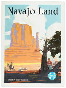
Rand McNally/Santa Fe Railroad Map of Iowa-1912JM Hobby Supply and Railroad Artifact Auctions4.4(126)See Sold PriceFeb 24, 2024
NICOLAES VISSCHER (NETHERLANDS, 1618-1709) MAP OF THE NEW WORLDThomaston Place Auction Galleries4.4(386)See Sold PriceFeb 24, 2024
17TH C. WORLD MAP BY NICOLAES VISSCHER (NETHERLANDS, 1618-1709)Thomaston Place Auction Galleries4.4(386)See Sold PriceFeb 24, 2024
Lot of Six Mixed Atlas Cabooses-HO Scale-New in BoxJM Hobby Supply and Railroad Artifact Auctions4.4(126)See Sold PriceFeb 25, 2024
SoldMAP - Southern US & Mexico. D'AnvilleSouthern United States, Mexico & Central America. D'Anville/Santini, Carte du Mexique, et de la Nouvelle Espagne, Contenant la Partie Australe de l'Amerique Septentle., 1779 (dated). Hand Color. A lovSee Sold Price
MAP - Southern US & Mexico. D'AnvilleSouthern United States, Mexico & Central America. D'Anville/Santini, Carte du Mexique, et de la Nouvelle Espagne, Contenant la Partie Australe de l'Amerique Septentle., 1779 (dated). Black & White. ASee Sold Price
Seutter Map of Mexico Southern US & Gulf 1700sMappa Geographica Regionem Mexicanam et Floridam. By Matthaeus Seutter. Hand-colored copper plate engraving, circa early 18th c. 20 x 24" plate size. Some tears at bottom and a few other margins.See Sold Price
West IndiesTitle/Content of Map: West Indies Date: c1818 Cartographer: HARRISON Publisher: HARRISON Size: 9.8Height - 15.8Width Map detailing extreme southern part of US, most of Mexico, Yucatan, Hondura, PanamaSee Sold Price
West IndiesTitle: West Indies Publication Date: c1818 Cartographer: HARRISON Publisher: HARRISON Size: 9.8Height - 15.8Width Map detailing extreme southern part of US, most of Mexico, Yucatan, Hondura, Panama anSee Sold Price
West IndiesTitle: West Indies Cartographer: HARRISON Publisher: HARRISON Height: 9.8 Width: 15.8 Map detailing extreme southern part of US, most of Mexico, Yucatan, Hondura, Panama and the West Indies. Modern coSee Sold Price
Mexico and Central AmericaTitle/Content of Map: Mexico and Central America Date Printed: 1863 Cartographer: WELL, J./SHERMAN, G.E. Size: 8.3X10.5 Map showing southern part of U.S. Arizona is lower half of New Mexico. MarginalSee Sold Price
SoldMexico and Central AmericaTitle/Content of Map: Mexico and Central America Date: 1863 Cartographer: WELL, J./SHERMAN, G.E. Publisher: MCNALLY'S GEOGRAPHY Size: 8.3Height - 10.5Width Map showing southern part of U.S. Arizona isSee Sold Price
Map of Mexico 1867Title: Impero del Messico Author: Naymiller & Allodi Description: Copper-engraved map, hand-colored in outline (possibly later). 31.8x41.6 cm. (12¼x16¼).Mexico and the southern U.S.; although the maSee Sold Price
SoldMAP, US & Mexico, TallisSouthern United States & Mexico. John Tallis, Mexico, California and Texas, from Illustrated Atlas and Modern History of the World, 1850 (circa). Hand Color. This is the second, and most desirable, stSee Sold Price
Mexico, Central America and the West IndiesTitle: Mexico, Central America and the West Indies Publisher: A.G.S. Height: 30 Width: 43 Excellent Wall Map for putting us in a better perspective with our southern neighbors. Southern U.S. with allSee Sold Price
SoldU S Coast Survey 1896 LG Map. New Orleans Texas Florida"Sketch of General Progress June 30. 1896" Showing Southern, Eastern and Mid West States, incl Florida, Texas, Gulf of Mexico, Georgia etc. Large Lithograph Map Published 1896, Washington for "U.S. CoSee Sold Price
Santini/d'Anville: Antique Map of Southeast US, 1784TITLE/CONTENT OF MAP: 'Partie Méridionale de la Louisiane, avec la Floride, la Caroline et la Virginie par le Sr. d'Anville. À Venise par P. Santini. Chez Mr. Remondini [Southern part of Louisiana,See Sold Price
SoldSantini (P.) Mexico & Central AmericaSantini (P.) Carte du Mexique, et de la Nouvelle Espagne, from the southern tip of California to Florida and Cuba, south to Costa Rica, after D'Anville, engraved map with original hand-colourSee Sold Price
Mexico, Central America and the West IndiesTitle/Content of Map: Mexico, Central America and the West Indies Date: c1938 Publisher: A.G.S. Size: 30Height - 43Width Excellent Wall Map for putting us in a better perspective with our southern neiSee Sold Price
SoldMAP, Southern US, CareySouthern United States. Carey & Warner, The Southern States and Missisippi Territory, 1814 (circa). Hand Color. This is a scarce map that covers current-day Tennessee, North Carolina, South Carolina,See Sold Price
SoldMAP - Southern US. Van der AaColonial Southern United States. Pieter van der Aa, La Floride, Suivant les Nouvelles Observations de Messrs. de l'Academie Royale des Sciences, Etc., 1713 (circa). Black & White. This handsome map ofSee Sold Price
SoldMap, Southern U.S. , 1839Map, Southern U.S. , 1839 - Hand-tinted paper map, flat-mounted on art canvas backing. Rests in a rolled position. From Roswell C. Smith 'Smith's Geography for Schools', (Hartford, 1839)' Drawn & EngrSee Sold Price
MAP, Southern US, LucasSouthern United States. Fielding Lucas Jr., Mississippi Territory, 1816 (circa). Black & White. This early map of Mississippi Territory covers the region of present-day Mississippi and Alabama. At theSee Sold Price
MAP, US & Mexico, PrevostSouthwestern United States & Mexico. Anton Francois Prevost, Carte de la Californie d'Apres les Observations le Plus Exactes, pour Servir a l'Histoire Generale des Voyages, from Histoire Generale desSee Sold Price
MAP - US & Mexico. EttlingUnited States & Mexico. Theodor Ettling, Map of the United States of North America, Upper & Lower Canada New Brunswick, Nova Scotia & British Columbia Mexico Cuba, Jamaica, St. Domingo and the BahamaSee Sold Price
MAP, US & Mexico, Von EulerSouthwestern United States & Mexico. Leonhard von Euler, Americae Septentrionalis Pars III, from Atlas Geographicus Omnes Orbis Terrarum…, 1760 (circa). Hand Color. This scarce map is one sheet of vSee Sold Price
SoldThree (3) 19th C. Maps, Paris, Southern USThree (3) maps, including: 1834 map, Southern US, 17" x 13 1/2", framed 27" x 23", good condition; 1834 map printed Paris, 17" x 13 1/2", framed 27" x 23", good condition; 19th Century dated 1834 PariSee Sold Price
Sold18TH CENTURY MAP OF SOUTHERN US & SPANISH FLORIDAPrinted map of the early US-Spanish border in the south. It shows US states of Virginia, North Carolina and Georgia extending all the way to the Mississippi River. Also portrays the borders of East anSee Sold Price
Rare "Santo Nino" colonial Guatemala or Southern Mexico, 18th century, with natural hair eyelashesTemplum Fine Art Auctions4.3(8)See Sold PriceFeb 28, 2024
1816 MAP SOUTHERN PART OF RUSSIA or MUSCOVY in EUROPE copper engraving ANTIQUEJasper524.5(9.8k)See Sold PriceFeb 27, 2024
Mexico, Central America and West Indies Physical PoliticalJasper524.5(9.8k)See Sold PriceFeb 27, 2024