SoldEARLY GERMAN MAP OF THE AMERICASEARLY GERMAN MAP OF THE AMERICAS: Early German map of the America's, by Sebastian Muenster (1489-1552). This particular antique map is Circa 1540. In frame with UV protective glass. Approx. 21.5" h xSee Sold Price
SoldLarge Map of the Americas by Homann, c. 1720MapsLarge Map of the Americas by Homann c. 1720, German Cartographer's Map of North and South America, Very Fine. 20.25" x 24" hand-colored map with two large uncolored pictorial cartouches.See Sold Price
SoldLarge Map of the Americas by Homann, c. 1720MapsLarge Map of the Americas by Homann c. 1720, German Cartographer’s Map of North and South America, Very Fine. 20.25” x 24” hand-colored map with two large uncolored pictorial carSee Sold Price
SoldLarge Map of the Americas by Homann, c. 1720MapsLarge Map of the Americas by Homann c. 1720, German Cartographer’s Map of North and South America, Very Fine. 20.25” x 24” hand-colored map with two large uncolored pictorial carSee Sold Price
SoldEarly German MapOceanvs Germanics, nova totius Belgii sive Germania Inferioris Framed size 27 1/4" x 23 1/4"See Sold Price
SoldEarly German Map of the Eastern United StatesWeiland, Carl F., "Der Oestliche Theil der Verinigten Staaten von Nord America nebst dem bewohnstesten heile von Canada" (Weimar: Geographisches Instituts, 1835), colored borders, presented in modernSee Sold Price
SoldEarly German Map 18" x 22 1/2" sight. Framed 21 1/2" xEarly German Map 18" x 22 1/2" sight. Framed 21 1/2" x 25"See Sold Price
SoldThree Early German Maps of EuropeThree early European maps, created in Germany, depicting Deutschland (Germany) and Frankreich (France) and Europa (Europe) each measures approx. 16" x 12" ID all in matching framesSee Sold Price
Sold20th C. Print of German Map20th century photo-mechanical reproduction of an early German map, 38 1/4" x 26 1/4", 40 3/4" x 28 3/4" (frame).See Sold Price
SoldEARLY MAP OF THE AMERICAN EASTERN SEABOARD BY HOMANNEarly German map of the American eastern seaboard, 23 1/2" x 19 3/4", published circa 1745 by Nuremburg cartographer Homann Erben. Given the Latin title "Domina Anglorum in America Septentrionali", thSee Sold Price
20th C. Print of German Map20th century photo-mechanical reproduction of an early German map, 38 1/4" x 26 1/4", 40 3/4" x 28 3/4" (frame).See Sold Price
SoldRARE EARLY MAP OF AMERICAS WITH LATER NOTATION -RARE EARLY MAP OF AMERICAS WITH LATER NOTATION - "Americae, nova Tabula" by Willem Janszoon Blaeu, Amsterdam, circa 1650, hand colored engraving on two joined sheets, printed prior to the 1700 editionSee Sold Price
SoldEarly Americas Map [Americas Map]20th-century (exact date unknown) of early Americas geology. Beautiful colors and detail. Measures 15.125-in. x 19.625-in. sheet size. In VG/EX condition, with warping upper and lower margins. UnframeSee Sold Price
SoldEarly 1800" German Map of North America:Early 1800" German Map of North America: "VEREINIGTE STATEN von NORD-AMERICA und CANADA" From Stieler Schul Atlas No XIXb. 8" x 9" Matted in Clear Plastic Sleeve. (70-150)See Sold Price
SoldGerman map of Americas 1800Title: Charte von America, Nac den neuesten Entdeckungewn und astronomischen Ortsbestimmunden berichliget und geseichnet Author: Reinecke, Johann Matthais Christoph Description: Copper-engraved map, hSee Sold Price
SoldSigned work on early map of AmericasHeading: Author: Nunn, George E. Title: The Mappemonde of Juan De La Cosa: A Critical Investigation of its Date Place Published: Jenkintown, Pennsylvania Publisher:George H. Beans Library Date PSee Sold Price
1566 MAP TOLETUM CITY ON HILLEarly German? colored map dated 1566 titled TOLETUM with a city on hill beside a river, 18 x 23 inches. Loss of 3 x 1 inch section on right margin and small loss on lower left corner.See Sold Price
SoldEarly German Hand Colored MapHand colored map. Die Stat Swybuschin; 13.5in. X 18in.(image size)See Sold Price
SoldEARLY MAP OF THE AMERICA'Sdated 1631 Sight- 15 1/2" x 20 1/2" Overall- 24 1/2" x 27 1/2"See Sold Price
SoldFIVE EARLY MAPS OF THE AMERICASFIVE EARLY MAPS OF THE AMERICAS. Comprising five early maps including a Homann Heirs 1746 Map of the Americas entitled "Americae Mappa Generalis" with cartouche depicting early Native Americans. ImagSee Sold Price
SoldAmerica, Rare Early Map of the Americas"America", Rare Early Map of the Americas by Jodocus Hondius (Flemish/Dutch, 1563-1612) for a French edition of Mercator's Atlas, North and South America, hand-colored copper engraved map, published ASee Sold Price
SoldEARLY MAP OF THE AMERICASAmericae nova Tabula. Auct: Guilielmo Blaeuw; Engraving (framed); 14 1/2" x 22" (sight)See Sold Price
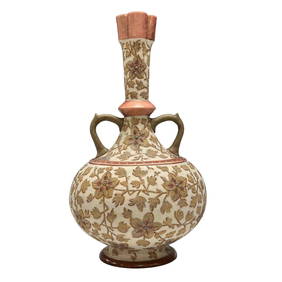
Early German Royal Rudolstadt Textured VasePremier Auction Galleries4.3(329)See Sold PriceMar 09, 2024
An early German glazed ceramic sealed beared man jugOstantix Auctions4.4(10)See Sold PriceFeb 28, 2024
Early German Bible, Another Bible, A.B. Frost BookKeystone Auction LLC4.6(922)See Sold PriceMar 01, 2024
Early German pewter advertising beer steinBaker's Antiques and Auctions3.3(462)See Sold PriceFeb 27, 2024
Early German Beer stein with pewter lidBaker's Antiques and Auctions3.3(462)See Sold PriceFeb 27, 2024
Early German beer stein with pewter lidBaker's Antiques and Auctions3.3(462)See Sold PriceFeb 27, 2024
Early German beer stein with dragon handleBaker's Antiques and Auctions3.3(462)See Sold PriceFeb 27, 2024
Early German Chrysanthemums Tall Form VasePremier Auction Galleries4.3(329)See Sold PriceMar 29, 2024


![Early Americas Map [Americas Map] (1 of 4)](https://p1.liveauctioneers.com/5755/154409/77936932_1_x.jpg?height=282&quality=70&version=1573094011)