ATLAS of ANTIENT GEOGRAPHY by SAMUEL BUTLER 1843John McInnis Auctioneers,LLC4.5(505)See Sold PriceFeb 24, 2024
18TH C. ANTIQUE MAP: FRENCH & INDIAN WAR, FRAMEDThomaston Place Auction Galleries4.4(393)See Sold PriceFeb 24, 2024
Rand McNally Railroad Map Cabinet w/ 21 Railroad MapsRail & Road Auctions4.6(165)See Sold PriceMar 08, 2024
Keith Haring - Ink on New York Map, Best Buddies, Inscribed, Signed, and DatedSapphire Auction Gallery4(67)See Sold PriceMar 02, 2024
LATE 17TH C. FRENCH MAP OF THE NEW WORLD BY ALEXIS-HUBERT JAILLOT (1632-1712)Thomaston Place Auction Galleries4.4(393)See Sold PriceFeb 24, 2024
Central Railroad of New Jersey Map of Sandy Hook Route-ca. 1903JM Hobby Supply and Railroad Artifact Auctions4.4(127)See Sold PriceFeb 24, 2024
Lot of Six Mixed Atlas Box Cars-HO Scale-New in BoxJM Hobby Supply and Railroad Artifact Auctions4.4(127)See Sold PriceFeb 25, 2024
Rand McNally/Santa Fe Railroad Map of Iowa-1912JM Hobby Supply and Railroad Artifact Auctions4.4(127)See Sold PriceFeb 24, 2024
NICOLAES VISSCHER (NETHERLANDS, 1618-1709) MAP OF THE NEW WORLDThomaston Place Auction Galleries4.4(393)See Sold PriceFeb 24, 2024
17TH C. WORLD MAP BY NICOLAES VISSCHER (NETHERLANDS, 1618-1709)Thomaston Place Auction Galleries4.4(393)See Sold PriceFeb 24, 2024
Lot of Six Mixed Atlas Cabooses-HO Scale-New in BoxJM Hobby Supply and Railroad Artifact Auctions4.4(127)See Sold PriceFeb 25, 2024
SoldRARE EARLY MAP OF AMERICAS WITH LATER NOTATION -RARE EARLY MAP OF AMERICAS WITH LATER NOTATION - "Americae, nova Tabula" by Willem Janszoon Blaeu, Amsterdam, circa 1650, hand colored engraving on two joined sheets, printed prior to the 1700 editionSee Sold Price
SoldRARE EARLY MAP OF AFRICA WITH LATER NOTATIONS -RARE EARLY MAP OF AFRICA WITH LATER NOTATIONS - "Nigritarium Regio" by Willem Janszoon Blaeu, Amsterdam, circa 1650, hand colored engraving on two joined sheets, printed prior to the crack in the platSee Sold Price
SoldRARE EARLY MAP OF THE AMERICAS - Hondius, HenricusRARE EARLY MAP OF THE AMERICAS - Hondius, Henricus (1597-1651). America noviter delineata, [Amsterdam:] 1631 [or later]. Engraved hand-colored map of the Americas,with inset maps of the North and SoutSee Sold Price
SoldAmerica, Rare Early Map of the Americas"America", Rare Early Map of the Americas by Jodocus Hondius (Flemish/Dutch, 1563-1612) for a French edition of Mercator's Atlas, North and South America, hand-colored copper engraved map, published ASee Sold Price
SoldRARE EARLY MAP OF NORTH AMERICA - Matthias Seutter,RARE EARLY MAP OF NORTH AMERICA - Matthias Seutter, copperplate engraving on laid paper, with later hand coloring, circa 1730; "Recens Edita Totius novi Belgii in America Septentrionali siti DelineatoSee Sold Price
SoldRare Michael Mercator Map of the AmericasAmerica sive India Nova...Michael Mercator (c. 1567-1600). Engraved map with original hand color. Duisburg, 1595 (but Hondius: Amsterdam, 1613 or later). 15 x 18 1/2 inches visible, 26 x 29 inches fraSee Sold Price
Sold1926 LUFTHANSA AIRLINE PASSENGER PHOTO & EPHEMERAEarly Lufthansa photograph, air map, souvenir wings, ticket, notations detailing the passengers flight to London, photos of pilots and crew even the mascot, a rare grouping.See Sold Price
Sold1926 LUFTHANSA AIRLINES PASSENGER PHOTO & EPHEMERAEarly Lufthansa photograph, air map, souvenir wings, ticket, notations detailing the passengers flight to London, photos of pilots and crew even the mascot, a rare grouping.See Sold Price
Sold1926 LUFTHANSA AIRLINE PASSENGER PHOTO & EPHEMERAEarly Lufthansa photograph, air map, souvenir wings, ticket, notations detailing the passengers flight to London, photos of pilots and crew even the mascot, a rare grouping. Some photos are glued to iSee Sold Price
1926 LUFTHANSA AIRLINE PASSENGER PHOTO & EPHEMERAEarly Lufthansa photograph, air map, souvenir wings, ticket, notations detailing the passengers flight to London, photos of pilots and crew even the mascot, a rare grouping. Some photos are glued to iSee Sold Price
Early Porcelain Cartographic PlateA rare cartographic french porcelain plate depicting a map of the Americas. Surrounded by neo classical desings. The porcelain possibly paris porcelain or sevres blank with incised letters and numbersSee Sold Price
SoldRare & Early Map of Charleston, South Carolinalate 18th century. depicting the attack on Fort Moultree by Sir Peter Parker in 1776 and operations of Charleston. engraved for D. Gordon's History of the American War, T. Condor, London, England. imaSee Sold Price
SoldRARE EARLY MAP - "Walachia, Servia, Bulgaria, Romania"RARE EARLY MAP - "Walachia, Servia, Bulgaria, Romania" by Gerard Mercator, published by Blaeu, from the first edition, 1634, Amsterdam. Unframed. Centered on the lower Danube. 19 1/2" x 21 1/2" sheet.See Sold Price
SoldAntigua labeled Antego. RARE early map.Title: Antigua labeled Antego. RARE early map. Description: c1732/1736 from the Atlas Minor by Herman Moll, London. VERY IMPORTANT early map of the island. Showing all the settlements and plantations.See Sold Price
SoldRare & Early Map of North & South Carolinaby Henry Mouzon, published by Sawyer and Bennett, London, 1775. giving exceptional detail of key locations in both North & South Carolina. upper sheet: H21 1/2" W54 3/4" lower sheet: H21 1/4" W52 1/4"See Sold Price
SoldRARE EARLY MAP - Johann Baptiste Homann; "RegniRARE EARLY MAP - Johann Baptiste Homann; "Regni Mexicani seu Novae Hispaniae, Floridae, Novae Angliae, Carolinae, Virginiae et Pensylvania...", copper engraving with original hand coloring, 1720, NureSee Sold Price
SoldRare Early Map of the Mississippi River, ca. 1698Rare, Early Map of "...Northern America Situated between New Mexico and the Frozen Sea [:] together with the Course of the Great River Meschasipi..." by Father Louis Hennepin (Belgian/Spanish NetherlaSee Sold Price
SoldRare Early Map of MoscowRare early map of Moscow, 41" x 27". Provenance: Property from the estate of Joseph Raymond of Chestnut Hill, MA and Cape Cod, MA. Joseph was a serious collector and dealer of rare maps, prints, and eSee Sold Price
SoldRare early map showing United StatesHeading: Author: Stackhouse, Thomas Title: North America in its present Divisions, agreeable to the Peace Place Published: London Publisher:Published by T. Stackhouse Date Published: June 1sSee Sold Price
SoldRare Early Map of MoscowRare early map of Moscow, 41" x 27". Provenance: Property from the estate of Joseph Raymond of Chestnut Hill, MA and Cape Cod, MA. Joseph was a serious collector and dealer of rare maps, prints, and eSee Sold Price
Rare early map of MinnesotaHeading: (Minnesota) Author: Sewall, J.S. Title: Sectional Map of the Surveyed Portion of Minnesota and the North Western Part of Wisconsin Place Published: Boston Publisher:D.D. Merrill Date PubSee Sold Price
Antigua. RARE early mapTitle: Antigua. RARE early map Description: By. H. Moll. From. Atlas minor. Published. London. Date/Period: 1729-1736 Materials:Copperplate engraved Dimensions:16 1/4 x 12 1/3” Reserve: $200.00 ShipSee Sold Price
SoldRare early map of California Gold RegionHeading: Author: Butler, Benjiman F. Title: Map of the Gold Region California 1851 Place Published: San Francisco Publisher:Lith. and Published by B. F. Butler Date Published: 1851 DesSee Sold Price
Antigua. RARE early map.Title: Antigua. RARE early map. Date/Period: 1729-1736 Materials: Copperplate engraved Dimensions: 16 1/4 x 12 1/3” By. H. Moll. From. Atlas minor. Published. London. Reserve: $180.00 Shipping: DomeSee Sold Price
Central Anatolia 16th / 17th Century Karapinar Long Rug Fragment (mounted) 3 ft 0 in x 1 ft 6 inNazmiyal Auctions4.4(34)See Sold PriceFeb 25, 2024
Ohio and Pennsylvania RR 2nd Annual Report-1850JM Hobby Supply and Railroad Artifact Auctions4.4(127)See Sold PriceFeb 24, 2024
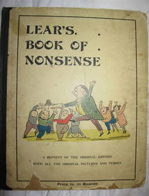
EDWARD LEAR Book Of Nonsense Early ca1890 Routledge Printing RareLuis Porretta Fine Arts4.3(10)See Sold PriceMar 02, 2024
ANNIE BEAN Breath of a ROSE 1916 1st Edition Rare Poetry Book Early CaliforniaLuis Porretta Fine Arts4.3(10)See Sold PriceMar 02, 2024
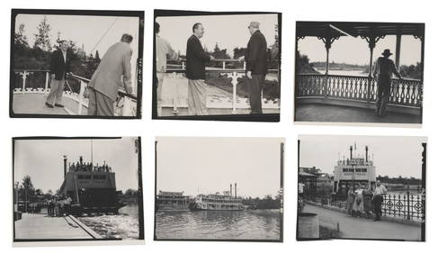
A Set of Early 1955 Aerial Disneyland Photographs.Van Eaton Galleries4.6(99)See Sold PriceMar 02, 2024
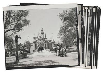
A Collection of 1955 Main Street U.S.A. Photographs.Van Eaton Galleries4.6(99)See Sold PriceMar 02, 2024
Chatelain - Map of the Americas and Details and Insets of Government CounselsTrillium Antique Prints & Rare Books4.5(32)See Sold PriceFeb 24, 2024
Chatelain - 3 Maps of the British Isles (England, Ireland, Scotland)Trillium Antique Prints & Rare Books4.5(32)See Sold PriceFeb 24, 2024