ATLAS of ANTIENT GEOGRAPHY by SAMUEL BUTLER 1843John McInnis Auctioneers,LLC4.6(502)See Sold PriceFeb 24, 2024
18TH C. ANTIQUE MAP: FRENCH & INDIAN WAR, FRAMEDThomaston Place Auction Galleries4.4(386)See Sold PriceFeb 24, 2024
Rand McNally Railroad Map Cabinet w/ 21 Railroad MapsRail & Road Auctions4.6(165)See Sold PriceMar 08, 2024
Keith Haring - Ink on New York Map, Best Buddies, Inscribed, Signed, and DatedSapphire Auction Gallery4(67)See Sold PriceMar 02, 2024
LATE 17TH C. FRENCH MAP OF THE NEW WORLD BY ALEXIS-HUBERT JAILLOT (1632-1712)Thomaston Place Auction Galleries4.4(386)See Sold PriceFeb 24, 2024
Central Railroad of New Jersey Map of Sandy Hook Route-ca. 1903JM Hobby Supply and Railroad Artifact Auctions4.4(126)See Sold PriceFeb 24, 2024
Lot of Six Mixed Atlas Box Cars-HO Scale-New in BoxJM Hobby Supply and Railroad Artifact Auctions4.4(126)See Sold PriceFeb 25, 2024
Rand McNally/Santa Fe Railroad Map of Iowa-1912JM Hobby Supply and Railroad Artifact Auctions4.4(126)See Sold PriceFeb 24, 2024
NICOLAES VISSCHER (NETHERLANDS, 1618-1709) MAP OF THE NEW WORLDThomaston Place Auction Galleries4.4(386)See Sold PriceFeb 24, 2024
17TH C. WORLD MAP BY NICOLAES VISSCHER (NETHERLANDS, 1618-1709)Thomaston Place Auction Galleries4.4(386)See Sold PriceFeb 24, 2024
Lot of Six Mixed Atlas Cabooses-HO Scale-New in BoxJM Hobby Supply and Railroad Artifact Auctions4.4(126)See Sold PriceFeb 25, 2024
The Islands of NEW ZEALAND. Tavai PoenammooTitle/Content of Map: 'THE ISLANDS OF NEW ZEALAND.' Date Printed: The map is indicated to have been correctd to 1844. This edition of the map was published in 1846 Image Size: Approx 40.5 x 33.0cm, 16See Sold Price
The Islands of NEW ZEALAND. Tavai PoenammooTITLE/CONTENT OF MAP: 'THE ISLANDS OF NEW ZEALAND.' DATE PRINTED: The map is indicated to have been correctd to 1844. This edition of the map was published in 1846 IMAGE SIZE: Approx 40.5 x 33.0cm, 16See Sold Price
The Islands of NEW ZEALAND. Tavai PoenammooTITLE/CONTENT OF MAP: 'THE ISLANDS OF NEW ZEALAND.' DATE PRINTED: The map is indicated to have been correctd to 1844. This edition of the map was published in 1846 IMAGE SIZE: Approx 40.5 x 33.0cm, 16See Sold Price
The Islands of NEW ZEALAND. Tavai PoenammooTITLE/CONTENT OF MAP: 'THE ISLANDS OF NEW ZEALAND.' Date: The map is indicated to have been correctd to 1844. This edition of the map was published in 1846 IMAGE SIZE: Approx 40.5 x 33.0cm, 16 x 13 inSee Sold Price
The Islands of NEW ZEALAND. Tavai PoenammooTITLE/CONTENT OF MAP: 'THE ISLANDS OF NEW ZEALAND.' The top image on the right hand side shows the entire map. DATE PRINTED: The map is indicated to have been correctd to 1844. This edition of the mapSee Sold Price
SDUK: Antique Map of Islands of New Zealand, 1846Title/Content of Map: 'THE ISLANDS OF NEW ZEALAND.' Tavai Poenammoo Eaheinomauwe Date Printed: The map is indicated to have been correctd to 1844. This edition of the map was published in 1846 Image SSee Sold Price
Pre-European Maori NEW ZEALAND. Tavai PoenammooTITLE/CONTENT OF MAP: 'THE ISLANDS OF NEW ZEALAND.' DATE PRINTED: This map was originally published by The Society for the Diffusion of Useful Knowledge in 1838; this date is printed on the map. ThisSee Sold Price
Pre-European Maori NEW ZEALAND. Tavai PoenammooTITLE/CONTENT OF MAP: 'THE ISLANDS OF NEW ZEALAND.' The top image on the right hand side shows the entire map. To view a close up of the map showing the level of printed detail, please click on the boSee Sold Price
Pre-European Maori NEW ZEALAND. Tavai PoenammooReserve Reduced! TITLE/CONTENT OF MAP: 'THE ISLANDS OF NEW ZEALAND.' The top image on the right hand side shows the entire map. To view a close up of the map showing the level of printed detail, pleasSee Sold Price
NEW ZEALAND provinces inc. Westland. Tavai PoenammooTITLE/CONTENT OF MAP: 'THE ISLANDS OF NEW ZEALAND.' The map shows the provinces of New Zealand including the short lived province of Westland which had been formed in 1873; New Zealand's provinces werSee Sold Price
Hawaiian Group or Sandwich Islands | New Zealand | YitiTitle: Hawaiian Group or Sandwich Islands | New Zealand | Yiti Group or Feejee Islands | Society Islands | Marquesas or Washington Is. | Galapacos Islands Publication Date: 1857 Cartographer: G. WoolwSee Sold Price
Sold1999-A CHATHAM ISLANDS (NEW ZEALAND) $2MILLENNIUM 1ST NOTE, CRISP UNC, MADE IN POLYMERSee Sold Price
1953 Raoul Islands New Zealand Registered Cover To Fairview NJ1953 Raoul Islands New Zealand Registered Cover To Fairview NJ Place Of Origin: New Zealand Quality: Used Grade: Ungraded Country/Region Of Manufacture: New Zealand Certification: Uncertified Pre-OwneSee Sold Price
SoldAltoon Sultan "Red Roofs, North Island, New Zealand"ALTOON SULTAN (American, 1948) "Red roofs, North Island, New Zealand," 1989, color engraving, image: 12 x 21 inches; overall (sheet/unframed): 27 x 37 inches, pencil signed lower right and dated, editSee Sold Price
Maori Weavers, Rotorua, North Island, New Zealand.Maori Weavers Whatarato Haira and Emire Paora, Rotorua, North Island, NZ. C1920. Very good contrast and tonality. Unknown photographer. 5.25 x 7.5 in. In archival mat. 11 x 14 inSee Sold Price
Maori Women Rotorua, North Island, New Zealand. C1920.Maori Women getting water below Papakura Geyser, Rotorua, North Island, NZ. C1920. Very good contrast and tonality. Unknown photographer. 7.5 x 5.5 in. In archival mat. 11 x 14 inSee Sold Price
Ruins of a Monument. Waihou Island. New Zealand. 1837.Print of steel engraving titled „Ruines d‘un Monument“.Drawn by Danvin.Engraved by Lejeune.From „L'univers pittoresque: histoire et description de tous les peuples“, Published by Firmin DidoSee Sold Price
South Island New Zealand railways. Open proposedTITLE/CONTENT OF MAP: 'Public Works Map showing the railways - South Island of New Zealand 1909' DATE: 1909 IMAGE SIZE: Approx 60.5 x 40.0cm, 24 x 15.75 inches (Large); Please note that this is a foldSee Sold Price
Old Original Map - General Map of the North Island, New Zealand - Cook StraitThis large fine lithograph layered coloured original map was published in the extremely significant Australian & New Zealand publication The Picturesque Atlas of Australasia between 1886-88. The PictuSee Sold Price
Portrait of a woman. Waihou Island. New Zealand. 1837.Print of steel engraving titled „Portrait de Femme“.Drawn by Danvin.Engraved by Casenave.From „L'univers pittoresque: histoire et description de tous les peuples“, Published by Firmin Didot FrSee Sold Price
Portrait of a man. Waihou Island. New Zealand. 1837.Print of steel engraving titled „Portrait d‘Homme. Ile Vaihou“.Drawn by Danvin.Engraved by Casanave.From „L'univers pittoresque: histoire et description de tous les peuples“, Published by FiSee Sold Price
Sold(3) EARLY MAPS and a PRINT AFTER WILLIAM BLAKEIncluding: 1886 Fulton's Territory of Alaska, Hawaiian Group or Sandwich Islands, New Zealand, Feejee Islands, 1867 "The World in Two Hemispheres" by Mitchell (colored) and "The Day of Judgement" prinSee Sold Price
SoldMap of Hawaii and New Zealand by Colton, 1855Map features: Hawaiian Group or Sandwich Islands. New Zealand. Viti Group or Feejee Islands. Society Islands. Marquesas or Washington Is. Galapagos Islands. Samoan or Navigators Island. This map is frSee Sold Price
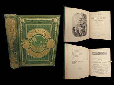
1789 Captain James Cook Life & Voyages Australia New Zealand Hawaii KippisSchilb Antiquarian Rare Books4.8(421)See Sold PriceMar 10, 2024
1871 Captain Cook Voyages Around the World Tahiti Hawaii Exploration AntarcticaSchilb Antiquarian Rare Books4.8(421)See Sold PriceMar 10, 2024
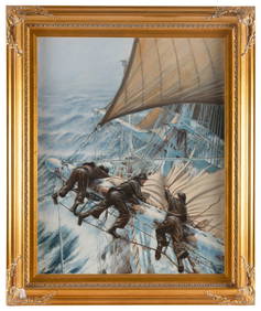
ANTHONY D. (A.D.) BLAKE (New Zealand, 1951-), "Reducing Sail at Sunset"., Oil on canvas, 30" x 24".Eldred's4.7(409)See Sold PriceFeb 27, 2024
ANTHONY D. (A.D.) BLAKE (New Zealand, 1951-), Furling sails in a storm., Oil on canvas, 30" x 24".Eldred's4.7(409)See Sold PriceFeb 27, 2024
ANTHONY D. (A.D.) BLAKE (New Zealand, 1951-), "The Flying Fish and John Gilpin Meet off Cape HornEldred's4.7(409)See Sold PriceFeb 27, 2024
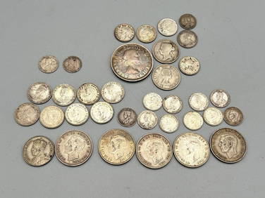
Group of Canada, New Zealand, Australia, Great Britain Silver CoinsDana J. Tharp Auctions4.7(268)See Sold PriceFeb 24, 2024
New Zealand 1 florin King George V, 1933 Silver coinBazaar of Persia4.3(23)See Sold PriceFeb 24, 2024
New Zealand - Maori wooden carved "Tiki" statuette.GOLDFIELD AUCTION4.3(32)See Sold PriceMar 02, 2024
1946 Guernsey Channel Islands England Reg Cover To New Zealand #N4 Blue PaperMynt Auctions4.6(680)See Sold PriceFeb 26, 2024
Cooke, George 1801 Print. Maori Tattoo Man, Warrior of New ZealandAlbion Auctions4.6(336)See Sold PriceMar 07, 2024
Large Group of Mixed Dates UK and Territories Coinage Australia New Zealand Hong KongGCB Estate Sales4.5(86)See Sold PriceMar 02, 2024
4 Antique Engraving Prints of New Zealand IndiansGreenwich Auction4.3(1.4k)See Sold PriceFeb 29, 2024
BATTEN JEAN: (1909-1982)International Autograph Auctions Europe S.L.4.5(52)See Sold PriceMar 14, 2024