ATLAS of ANTIENT GEOGRAPHY by SAMUEL BUTLER 1843John McInnis Auctioneers,LLC4.6(502)See Sold PriceFeb 24, 2024
18TH C. ANTIQUE MAP: FRENCH & INDIAN WAR, FRAMEDThomaston Place Auction Galleries4.4(386)See Sold PriceFeb 24, 2024
Rand McNally Railroad Map Cabinet w/ 21 Railroad MapsRail & Road Auctions4.6(165)See Sold PriceMar 08, 2024
Keith Haring - Ink on New York Map, Best Buddies, Inscribed, Signed, and DatedSapphire Auction Gallery4(67)See Sold PriceMar 02, 2024
LATE 17TH C. FRENCH MAP OF THE NEW WORLD BY ALEXIS-HUBERT JAILLOT (1632-1712)Thomaston Place Auction Galleries4.4(386)See Sold PriceFeb 24, 2024
Central Railroad of New Jersey Map of Sandy Hook Route-ca. 1903JM Hobby Supply and Railroad Artifact Auctions4.4(126)See Sold PriceFeb 24, 2024
Lot of Six Mixed Atlas Box Cars-HO Scale-New in BoxJM Hobby Supply and Railroad Artifact Auctions4.4(126)See Sold PriceFeb 25, 2024
Rand McNally/Santa Fe Railroad Map of Iowa-1912JM Hobby Supply and Railroad Artifact Auctions4.4(126)See Sold PriceFeb 24, 2024
NICOLAES VISSCHER (NETHERLANDS, 1618-1709) MAP OF THE NEW WORLDThomaston Place Auction Galleries4.4(386)See Sold PriceFeb 24, 2024
17TH C. WORLD MAP BY NICOLAES VISSCHER (NETHERLANDS, 1618-1709)Thomaston Place Auction Galleries4.4(386)See Sold PriceFeb 24, 2024
Lot of Six Mixed Atlas Cabooses-HO Scale-New in BoxJM Hobby Supply and Railroad Artifact Auctions4.4(126)See Sold PriceFeb 25, 2024
SoldLondon.- Cary (John) Cary's New and Accurate Plan ofLondon.- Cary (John) Cary's New and Accurate Plan of London and Westminster, the Borough of Southwark and parts adjacent, large detailed map showing from Kensington to the East India Docks, and from CSee Sold Price
SoldLondon.- Cary (John) Cary's New and Accurate Plan ofLondon.- Cary (John) Cary's New and Accurate Plan of London and Westminster, the Borough of Southwark and parts adjacent..., large detailed map showing from Kensington to the Stepney, and from CanonbuSee Sold Price
SoldCary (John) New and Accurate Plan of London and WeCary (John) New and Accurate Plan of London and Westminster, the Borough of Southwark and parts Adjacent......with an Alphabetical List of...500 of the most considerable Streets, from IslingtoSee Sold Price
SoldBLON Cary (John)BLON Cary (John) New and Accurate Plan of London and Westminster, the Borough of Southwark and parts Adjacent...... with an Alphabetical List of...500 of the most considerable Streets, from IsSee Sold Price
SoldLondon.- Cary (John) Cary's New Pocket Plan of London,NO RESERVE London.- Cary (John) Cary's New Pocket Plan of London, Westminster and Southwark ..., showing from Islington to Lambeth, and Hyde Park across to Mile End, with references to Public Offices,See Sold Price
SoldCary (George and John) Cary's New Plan of London aCary (George and John) Cary's New Plan of London and it's Vicinity,showing from Stoke Newington down to North Brixton, and Stratford across to Paddington, with the boundary of the Two-Penny PoSee Sold Price
SoldCary (George and John) Cary's New Plan of London aCary (George and John) Cary's New Plan of London and its Vicinity,from Newington Green to North Brixton and from East India Docks to Kensington Gore, title panel below, unrecorded edition showSee Sold Price
SoldCary (George and John) Cary's New Plan of London aCary (George and John) Cary's New Plan of London and it's Vicinity,showing from Stoke Newington down to North Brixton, and Stratford across to Paddington, with the boundary of the Two-Penny PoSee Sold Price
SoldCaryCary (George and John) Cary's New Plan of London and it's Vicinity, showing from Stoke Newington down to North Brixton, and Stratford across to Paddington, with the boundary of the Two-Penny Post areaSee Sold Price
SoldCary (J.) New Plan of London and its VicinityCary (John) Cary's New Plan of London and its Vicinity Shewing the Limits of the Two-penny Post Delivery,engraved plan, hand-coloured, 770 x 835mm., dissected and laid on linen, slight browninSee Sold Price
SoldCary (John) Cary's New Pocket Plan of London, WestCary (John) Cary's New Pocket Plan of London, Westminster and Southwark,showing from Islington down to Lambeth, and Hyde Park across to Mile End, with references to Public Offices, Post OfficeSee Sold Price
1812 Cary Map of London -- Cary's New and Accurate Plan of London and Westminster, the Borough ofTitle: 1812 Cary Map of London -- Cary's New and Accurate Plan of London and Westminster, the Borough of Southwark and Parts Adjacent Cartographer: J Cary Year / Place: 1812 London Map Dimension (in.)See Sold Price
Sold1802 Edition Cary's New Itinerary Great Roads“Cary’s New Itinerary or an Accurate Delineation of the Great Roads both Direct and Cross Throughout England and Wales With Many Principal Roads in Scotland”, by John Cary, London (1802). New biSee Sold Price
SoldA Cary's "New and Accurate Plan of London and WestA Cary's "New and Accurate Plan of London and Westminster, the Borough of Southwark and Parts Adjacent", with hand coloured sections laid on to linen, with keys to public buildings, churches and streeSee Sold Price
Cary's New Plan of London and its Vicinity, by J & G Cary. 67x85cm 1825 mapTitle: "Cary's New Plan of London and its Vicinity", by J & G Cary. 67x85cm 1825 map Description: Cary's New Plan of London and its Vicinity, 1825' by John & George Cary (1825). Antique folding city pSee Sold Price
London.- Wallis (John) A New and Accurate TopographicalLondon.- Wallis (John) & John Cary. A New and Accurate Topographical Survey of the Environs of London, within Twenty Miles of the Metropolis, from Ware to Dorking, and from Beaconsfield to Chelmsford,See Sold Price
SoldCary (John) Cary's New ItineraryCary (John) Cary's New Itinerary:On An Accurate Delineation of the Great Roads...,seventh edition, engraved title, folding map of England and Wales, linen backed, one fold split, one corner seSee Sold Price
SoldCary (John)Cary (John) Cary's New Itinerary: or an Accurate Delineation of the Great Roads... throughout England and Wales, sixth edition, large engraved folding map and 6 others, large map with tear, enSee Sold Price
SoldCary (John) New ItineraryCary (John) New Itinerary: or an Accurate Delineation of the Great Roads...throughout England and Wales,fourth edition, engraved large folding map and 4 folding maps, some offsetting, occaionaSee Sold Price
SoldJohn Cary, Map United States, Treaty of Peace 1783John Cary (London, 1754-1835) "An Accurate Map of the United States of America, with Part of the Surrounding Provinces agreeable to the Treaty of Peace of 1783", 1783 (created/published) Hand coloredSee Sold Price
Cary, John Cary's New Map of England and Wales withCary, John Cary's New Map of England and Wales with part of Scotland London: J. Cary, 1794. 4to, hand-coloured single-page map of England and Wales, diagram to illustrate scale and 76 map sections, haSee Sold Price
SoldJohn Cary 1806, Three Maps of North AmericaThree hand colored maps of North America by John Cary, London, 1806. 1st map - "A New Map of North America" showing continent of North America. 2nd map - "A New Map of Part of the United States contaiSee Sold Price
SoldCary, John.Cary, John. Cary's New and Correct English Atlas, being a New Set of County Maps. London: J. Cary, 1787, 4to, engraved title and dedication, general map and 46 engraved county maps hand-coloured in ouSee Sold Price
Sold[Noorthouck, John?] A New & Accurate Plan of the Cities[Noorthouck, John?] A New & Accurate Plan of the Cities of London & Westminster London: C. Dicey, [1772], 105 x 60cm, some hand-colouring in outline, laid-down to board, a little browning in patches,See Sold Price
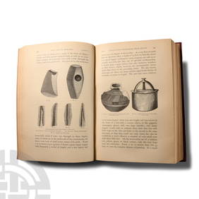
Archaeological Books - Schliemann - Troy and its Remains; A Narrative of Researches and DiscoveriesTimeLine Auctions Ltd.4.5(183)See Sold PriceMar 06, 2024
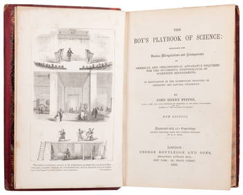
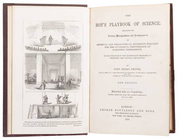
PEPPER, John Henry (1821 - 1900). The Boy’s Playbook of Sci...Potter & Potter Auctions4.6(539)See Sold PriceFeb 24, 2024
PEPPER, John Henry (1821 - 1900). The Boy’s Playbook of Sci...Potter & Potter Auctions4.6(539)See Sold PriceFeb 24, 2024
[ARCTIC]. BOWEN, Emanuel. A New & Accurate Map of the North...Potter & Potter Auctions4.6(539)See Sold PriceMar 07, 2024
Audubon, Amsterdam Ed - American Robin. 131Trillium Antique Prints & Rare Books4.5(30)See Sold PriceFeb 24, 2024
Map: A 19thC engraved and hand coloured map of Buckingham titled A New Map of BuckinghamshireClaydon Auctioneers Ltd4.3(125)See Sold PriceFeb 26, 2024
1764 MAP OF COUNTRIES THIRTY MILES ROUND LONDON antique 12.5 by 15"Jasper524.5(9.8k)See Sold PriceFeb 27, 2024
1738 RUSSIA SIBERIA & GREAT TARTARY Description illustrated ANTIQUE in ENGLISHJasper524.5(9.8k)See Sold PriceFeb 27, 2024
Fielding (Henry) The Works, with An Essay on His Life and Genius by Arthur Murphy, 10 vol., newForum Auctions4.3(52)See Sold PriceFeb 29, 2024
John Cooke 1800s Engraving View of Plymouth Fort & St Nicholas Island FRAMEDKCM Galleries4.7(164)See Sold PriceFeb 25, 2024
LE CARRE JOHN: (1931-2020)International Autograph Auctions Europe S.L.4.5(52)See Sold PriceMar 14, 2024
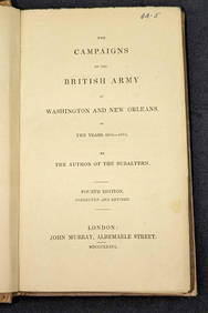
1836 The British Army at Washington & New Orleans HCRapid Estate Liquidators and Auction Gallery4.5(1.1k)See Sold PriceFeb 29, 2024


![[Noorthouck, John?] A New & Accurate Plan of the Cities (1 of 1)](https://p1.liveauctioneers.com/94/192556/97450835_1_x.jpg?height=282&quality=70&version=1612187148)
![[ARCTIC]. BOWEN, Emanuel. A New & Accurate Map of the North... (1 of 1)](https://p1.liveauctioneers.com/928/318880/171360917_1_x.jpg?height=282&quality=70&version=1707501302)