ATLAS of ANTIENT GEOGRAPHY by SAMUEL BUTLER 1843John McInnis Auctioneers,LLC4.5(505)See Sold PriceFeb 24, 2024
18TH C. ANTIQUE MAP: FRENCH & INDIAN WAR, FRAMEDThomaston Place Auction Galleries4.4(393)See Sold PriceFeb 24, 2024
Rand McNally Railroad Map Cabinet w/ 21 Railroad MapsRail & Road Auctions4.6(165)See Sold PriceMar 08, 2024
Keith Haring - Ink on New York Map, Best Buddies, Inscribed, Signed, and DatedSapphire Auction Gallery4.1(67)See Sold PriceMar 02, 2024
LATE 17TH C. FRENCH MAP OF THE NEW WORLD BY ALEXIS-HUBERT JAILLOT (1632-1712)Thomaston Place Auction Galleries4.4(393)See Sold PriceFeb 24, 2024
Central Railroad of New Jersey Map of Sandy Hook Route-ca. 1903JM Hobby Supply and Railroad Artifact Auctions4.4(127)See Sold PriceFeb 24, 2024
Lot of Six Mixed Atlas Box Cars-HO Scale-New in BoxJM Hobby Supply and Railroad Artifact Auctions4.4(127)See Sold PriceFeb 25, 2024
Rand McNally/Santa Fe Railroad Map of Iowa-1912JM Hobby Supply and Railroad Artifact Auctions4.4(127)See Sold PriceFeb 24, 2024
NICOLAES VISSCHER (NETHERLANDS, 1618-1709) MAP OF THE NEW WORLDThomaston Place Auction Galleries4.4(393)See Sold PriceFeb 24, 2024
17TH C. WORLD MAP BY NICOLAES VISSCHER (NETHERLANDS, 1618-1709)Thomaston Place Auction Galleries4.4(393)See Sold PriceFeb 24, 2024
Lot of Six Mixed Atlas Cabooses-HO Scale-New in BoxJM Hobby Supply and Railroad Artifact Auctions4.4(127)See Sold PriceFeb 25, 2024
A New & Accurate Chart of the Discoveries of Captn CookTITLE OF MAP (NOT PRINTED ON THE PAGE):'A New & Accurate Chart of the Discoveries of Captn Cook & other Later Circumnavigators : Exhibiting the whole coast of New South Wales, shewing the situations oSee Sold Price
A New & Accurate Chart of the Discoveries of Captn CookTITLE OF MAP (NOT PRINTED ON THE PAGE):'A New & Accurate Chart of the Discoveries of Captn Cook & other Later Circumnavigators : Exhibiting the whole coast of New South Wales, shewing the situations oSee Sold Price
A New & Accurate Chart of the Discoveries of Captn Cook… CONDER 1794 old mapTitle: A New & Accurate Chart of the Discoveries of Captn Cook… CONDER 1794 old map Description: A New & Accurate Chart of the Discoveries of Captn Cook & other Later Circumnavigators : ExhibitiSee Sold Price
SoldGeorge Augustus Baldwyn's Universal Geography, "A NewGeorge Augustus Baldwyn's Universal Geography, "A New Accurate Chart of the Discoveries of Cap't Cook, the Whole Coast of New South Wales, Coast of North America, Pacific Ocean, Cap't. Bligh," H. - 18See Sold Price
Bowen’s Map of New Holland, 1780A new & accurate chart of the discoveries made by the late Capt. Js. Cook and other distinguished, modern navigators made between the latitudes of 80 degs. north and 50 degs. south and extending to 26See Sold Price
SoldThomas Bowen Map of North and South PacificA New & Accurate Chart of the Discoveries made by the late Capt Jas Cook.....Exhibiting Botany Bay with the whole Coast of New South Wales in New Holland, also New Zealand, Norfolk and the various othSee Sold Price
Northeast Asia with Cook's discoveries 1794Heading: Author: Laurie & Whittle Title: The Asiatic Part of the Russian Empire from the Maps Published by the Imperial Academy of St. Petersburg, with the New Discoveries of Captn. Cook &c. Place PuSee Sold Price
Northeast Asia with Cook's discoveries 1794Heading: Author: Laurie & Whittle Title: The Asiatic Part of the Russian Empire from the Maps Published by the Imperial Academy of St. Petersburg, with the New Discoveries of Captn. Cook &c. Place PuSee Sold Price
Western half of Russian Empire 1794Heading: Author: Laurie & Whittle Title: The Asiatic Part of the Russian Empire from the Maps Published by the Imperial Academy of St. Petersburg, with the New Discoveries of Captn. Cook &c. Place PuSee Sold Price
Western half of Russian Empire 1794Heading: Author: Laurie & Whittle Title: The Asiatic Part of the Russian Empire from the Maps Published by the Imperial Academy of St. Petersburg, with the New Discoveries of Captn. Cook &c. Place PuSee Sold Price
SoldROBERTS, HENRY, A GENERAL CHART, 1784Roberts, Lieut. Henry A GENERAL CHART: EXHIBITING THE DISCOVERIES MADE BY CAPTN JAMES COOK IN THIS AND HIS TWO PRECEEDING VOYAGES, WITH THE TRACKS OF THE SHIPS UNDER HIS COMMAND [London, 1784] H. 60.5See Sold Price
A General chart exhibiting the discoveries of CaptnTITLE/CONTENT OF MAP: 'A General chart exhibiting the discoveries made by Captn. James Cook in this and his two preceeding voyages; with the tracks of the ships under his command' The top image on theSee Sold Price
SoldMap of Captn. James Cook Voyages, c. 1781MapsDiscoveries Made by Captain James Cook c. 1781, “A General Chart: Exhibiting the Discoveries made by Captn. James Cook in his First, Second and Third Voyages; with the Tracks of the Ships unSee Sold Price
SoldMap of Captn. James Cook Voyages, c. 1781MapsDiscoveries Made by Captain James Cook c. 1781, “A General Chart: Exhibiting the Discoveries made by Captn. James Cook in his First, Second and Third Voyages; with the Tracks of the Ships unSee Sold Price
Soldc.1781 Map-Captn. James Cook Voyagesc. 1781, “A General Chart: Exhibiting the Discoveries made by Captn. James Cook in his First, Second and Third Voyages; with the Tracks of the Ships under his Command", Fine. Overall size 12.25"See Sold Price
Soldc.1781 Map-Captn. James Cook VoyagesMapsDiscoveries Made by Captain James Cook c. 1781, “A General Chart: Exhibiting the Discoveries made by Captn. James Cook in his First, Second and Third Voyages; with the Tracks of the Ships unSee Sold Price
Soldc.1781 Map-Captn. James Cook VoyagesMapsc. 1781, “A General Chart: Exhibiting the Discoveries made by Captn. James Cook in his First, Second and Third Voyages; with the Tracks of the Ships under his Command", Fine. Overall size 12See Sold Price
A General chart exhibiting the discoveries of CaptnTITLE/CONTENT OF MAP: 'A General chart exhibiting the discoveries made by Captn. James Cook in this and his two preceeding voyages; with the tracks of the ships under his command' The top image on theSee Sold Price
SoldRoberts (H.) General Chart of Cook's VoyagesRoberts (Lieut. Henry) A General Chart, Exhibiting the Discoveries made by Capt.n James Cook in this and his two preceeding Voyages, with the Tracks of the Ships under his Command, world map oSee Sold Price
Soldc.1781 Map-Captn. James Cook VoyagesMapsc. 1781, “A General Chart: Exhibiting the Discoveries made by Captn. James Cook in his First, Second and Third Voyages; with the Tracks of the Ships under his Command", Fine. Overall size 12See Sold Price
A General chart exhibiting the discoveries of CaptnTITLE/CONTENT OF MAP: 'A General chart exhibiting the discoveries made by Captn. James Cook in this and his two preceeding voyages; with the tracks of the ships under his command' The top image on theSee Sold Price
Cartografia - Australasia - Faden, WilliamA General Chart Exhibiting the Discoveries Made by Capt.n James Cook in This and His Two Preceding Voyages; with the Tracks of the Ships Under His Command Carta geografica incisa in rame e con i confiSee Sold Price
SoldRoberts (Henry) Map of Capt Cook's voyagesRoberts (Henry) A General Chart; Exhibiting The Discoveries Made By Captn. James Cook in This and his two preceeding Voyages With The Tracks of The Ships Under His Command., engraved map, on tSee Sold Price
SoldChart of World with Cook's Voyages 1794Heading: (Cook, James) Author: Roberts, Henry Title: A General Chart: Exhibiting the Discoveries made by Captn. James Cook in this and his two preceding Voyages; with the Tracks of the Ships under hisSee Sold Price
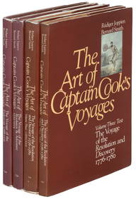
1789 Captain James Cook Life & Voyages Australia New Zealand Hawaii KippisSchilb Antiquarian Rare Books4.8(428)See Sold PriceMar 10, 2024
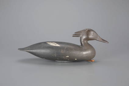
The McAlpin Horner Merganser Hen Decoy by Nathan Rowley Horner (1882-1942)Copley Fine Art Auctions4.5(40)See Sold PriceFeb 24, 2024
LATE 18TH C. VERY LARGE CHART OF NORTHEAST CANADA BY DES BARRES (1721-1824), 1780, FRAMEDThomaston Place Auction Galleries4.4(393)See Sold PriceFeb 24, 2024
LARGE LATE 17TH C. DUTCH CHART OF CANADA, GREAT LAKES, NEW FRANCE, LABRADOR, HUDSON BAY, BY PIERREThomaston Place Auction Galleries4.4(393)See Sold PriceFeb 24, 2024
CHART "LONG ISLAND SOUND FROM NEW YORK TO MONTOCK POINT ..." New York, 1830 21" x 77" sight. FramedEldred's4.7(419)See Sold PriceFeb 27, 2024
[ARCTIC]. BOWEN, Emanuel. A New & Accurate Map of the North...Potter & Potter Auctions4.6(545)See Sold PriceMar 07, 2024
Arrowsmith & Lewis - Map of the United StatesTrillium Antique Prints & Rare Books4.5(32)See Sold PriceFeb 24, 2024
LeRoy Neiman 'Femlin - Happy New Year 1992' Original ink & watercolor drawingWhite Knight Auction, Inc4.6(252)See Sold PriceFeb 25, 2024


![[ARCTIC]. BOWEN, Emanuel. A New & Accurate Map of the North... (1 of 1)](https://p1.liveauctioneers.com/928/318880/171360917_1_x.jpg?height=282&quality=70&version=1707501302)