ATLAS of ANTIENT GEOGRAPHY by SAMUEL BUTLER 1843John McInnis Auctioneers,LLC4.6(504)See Sold PriceFeb 24, 2024
18TH C. ANTIQUE MAP: FRENCH & INDIAN WAR, FRAMEDThomaston Place Auction Galleries4.4(389)See Sold PriceFeb 24, 2024
Rand McNally Railroad Map Cabinet w/ 21 Railroad MapsRail & Road Auctions4.6(165)See Sold PriceMar 08, 2024
Keith Haring - Ink on New York Map, Best Buddies, Inscribed, Signed, and DatedSapphire Auction Gallery4.1(67)See Sold PriceMar 02, 2024
LATE 17TH C. FRENCH MAP OF THE NEW WORLD BY ALEXIS-HUBERT JAILLOT (1632-1712)Thomaston Place Auction Galleries4.4(389)See Sold PriceFeb 24, 2024
Central Railroad of New Jersey Map of Sandy Hook Route-ca. 1903JM Hobby Supply and Railroad Artifact Auctions4.4(126)See Sold PriceFeb 24, 2024
Lot of Six Mixed Atlas Box Cars-HO Scale-New in BoxJM Hobby Supply and Railroad Artifact Auctions4.4(126)See Sold PriceFeb 25, 2024
Rand McNally/Santa Fe Railroad Map of Iowa-1912JM Hobby Supply and Railroad Artifact Auctions4.4(126)See Sold PriceFeb 24, 2024
NICOLAES VISSCHER (NETHERLANDS, 1618-1709) MAP OF THE NEW WORLDThomaston Place Auction Galleries4.4(389)See Sold PriceFeb 24, 2024
17TH C. WORLD MAP BY NICOLAES VISSCHER (NETHERLANDS, 1618-1709)Thomaston Place Auction Galleries4.4(389)See Sold PriceFeb 24, 2024
Lot of Six Mixed Atlas Cabooses-HO Scale-New in BoxJM Hobby Supply and Railroad Artifact Auctions4.4(126)See Sold PriceFeb 25, 2024
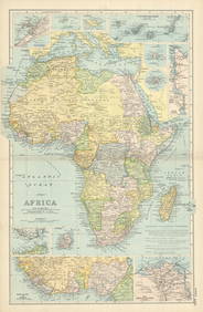
Bacon's Excelsior [Logo] Map of Wales andTitle: Bacon's Excelsior [Logo] Map of Wales and Monmouthshire... With Railways, Roads and Distances. Publicaiton Date: c1880 Cartographer: BACON, G. W. & CO. Publisher: G.W. BACON & CO. Size: 36.75HeSee Sold Price
Bacon's Excelsior [Logo] Map of Wales andTitle/Content of Map: Bacon's Excelsior [Logo] Map of Wales and Monmouthshire... With Railways, Roads and Distances. Date: c1880 Cartographer: BACON, G. W. & CO. Publisher: G.W. BACON & CO. Size: 36.7See Sold Price
Bacon's Excelsior [Logo] Map of South AmericaPublication Date: c1905 Title: Bacon's Excelsior [Logo] Map of South America Cartographer: BACON, G. W. & CO. Publisher: G.W. BACON & CO./BACON'S GEOGRAPHICAL ESTABLISHMENT Height: 63 Width: 48 Old veSee Sold Price
SoldVintage Bacons Excelsior Map of North America 1880sPrinted in London by G. W. Bacon & Co., Ltd., circa 1880. Chromolithograph laid on canvas with both original wood hangers. Approx. 38 in. H x 30 in. WSee Sold Price
SoldBacon's Excelsior Map of The WorldOn Mercator's Projection, printed in London by G. W. Bacon & Co., Ltd., circa 1880. Chromolithograph laid on canvas with both original wood hangers. 39 1/2" x 30".See Sold Price
Three Printed Wall Maps, second quarter 20th centuThree Printed Wall Maps, second quarter 20th century, Bacon's Excelsior Map of the United States, for J.L. Hammett Co. and Map of the World, and George Philip School Room Map of Europe</See Sold Price
SoldBacon (G.W.) Excelsior map...Bacon (G.W.) Excelsior map of Norfolk & Suffolk, colour map, mounted on linen, folded, in original cloth covers, London, 127 Strand, [c. 1880-90]; and another folding map and 4 topographical eSee Sold Price
Bacon's Motoring Map of England & Wales (South Sheet)Title/Content of Map: Bacon's Motoring Map of England & Wales (South Sheet) Date: c1920 Cartographer: BACON, G. W. & CO. Publisher: G.W. BACON & CO. Size: 27.75Height - 38Width Golf links with club hoSee Sold Price
Bacons Motor Road Map: England & Wales. South c.1920sBacons Motor Road Map. England & Wales. South Sheet. Scale Eight Miles to One Inch Publisher. G.W. Bacon & Co, Ltd. Showing Roads, Railways, & Distances. Folding, gauze mounted color road map in greySee Sold Price
Bacons Motor Road Map: England & Wales, North. c.1920sBacons Motor Road Map. North Sheet. England & Wales. Scale. 8 miles = 1 inch Publisher. G.W. Bacon & Co, Ltd. Price on cover 5/=. Folded colour map 29 x 39. Grey/Blue cloth boards 7.5x4.5x0.5 inches (See Sold Price
Bacons Motor Road Map: England & Wales, North. c.1920sBacons Motor Road Map. North Sheet. England & Wales. Scale. 8 miles = 1 inch Publisher. G.W. Bacon & Co, Ltd. Price on cover 5/=. Folded colour map 29 x 39. Grey/Blue cloth boards 7.5x4.5x0.5 inches (See Sold Price
Bacons Motor Road Map: England & Wales, North. c.1920sBacons Motor Road Map. North Sheet. England & Wales. Scale. 8 miles = 1 inch Publisher. G.W. Bacon & Co, Ltd. Price on cover 5/=. Folded colour map 29 x 39. Grey/Blue cloth boards 7.5x4.5x0.5 inches (See Sold Price
Bacons Motor Road Map: England & Wales. South c.1920sBacons Motor Road Map. England & Wales. South Sheet. Scale Eight Miles to One Inch Publisher. G.W. Bacon & Co, Ltd. Showing Roads, Railways, & Distances. Folding, gauze mounted color road map in greySee Sold Price
Bacons Motor Road Map: England & Wales. South c.1920sBacons Motor Road Map. England & Wales. South Sheet. Scale Eight Miles to One Inch Publisher. G.W. Bacon & Co, Ltd. Showing Roads, Railways, & Distances. Folding, gauze mounted color road map in greySee Sold Price
Bacons Motor Road Map: England & Wales. South c.1920sBacons Motor Road Map. England & Wales. South Sheet. Scale Eight Miles to One Inch Publisher. G.W. Bacon & Co, Ltd. Showing Roads, Railways, & Distances. Folding, gauze mounted color road map in greySee Sold Price
Bacons Motor Road Map: England & Wales. South c.1920sBacons Motor Road Map. England & Wales. South Sheet. Scale Eight Miles to One Inch Publisher. G.W. Bacon & Co, Ltd. Showing Roads, Railways, & Distances. Folding, gauze mounted color road map in greySee Sold Price
Bacons Motor Road Map: England & Wales, North. c.1920sBacons Motor Road Map. North Sheet. England & Wales. Scale. 8 miles = 1 inch Publisher. G.W. Bacon & Co, Ltd. Price on cover 5/=. Folded colour map 29 x 39. Grey/Blue cloth boards 7.5x4.5x0.5 inches (See Sold Price
Bacons Motor Road Map: England & Wales, North. c.1920sBacons Motor Road Map. North Sheet. England & Wales. Scale. 8 miles = 1 inch Publisher. G.W. Bacon & Co, Ltd. Price on cover 5/=. Folded colour map 29 x 39. Grey/Blue cloth boards 7.5x4.5x0.5 inches (See Sold Price
SoldBacons Motor Road Map: England & Wales, North. c.1920sTitle/Content of Map:Bacons Motor Road Map: England & Wales, North. c.1920s Date: c.1920s Cartographer: Bacons Motor Road Maps Material/Medium: Folded in boards color map reinforced with original gauzSee Sold Price
Bacons Motor Road Map: England & Wales. South c.1920sTitle/Content of Map:Bacons Motor Road Map: England & Wales. South c.1920s Date: c.1920s Cartographer: Material/Medium: Folded in boards color map reinforced with original gauze. Size: folder 7.5x4.5xSee Sold Price
SoldIRISH & ENGLISH DICTIONARIES, ATLASES AND MAPSIRISH & ENGLISH DICTIONARIES, ATLASES & MAPS INCLUDING 2 VOLS A TOPOGRAPHICAL DICTIONARY OF IRELAND 1837 BY SAMUEL LEWIS, IRISH ATLAS, INDEX TO IRISH ATLAS, AND BACON'S MOTOR ROAD MAP ENGLAND & WALESSee Sold Price
Bacon's Motor Road Map. England And Wales. South Sheet,Title: Bacon's Motor Road Map. England And Wales. South Sheet, Date: c1912 Cartographer: BACON, G. W. & CO. Publisher: G.W. BACON & CO., LTD. Size: 29Height - 39Width Additional Information: showing rSee Sold Price
FLYING A TOURING SERVICE U.S. ROAD MAPS TIN WALL DISPLAY.Dan Morphy Auctions4.2(1.3k)See Sold PriceFeb 25, 2024
10 Dollars - Elizabeth II Map of the WorldWeatherham Estate Treasures3.9(157)See Sold PriceMar 07, 2024
Portfolio of 15 County Maps by Robert Morden (English 1650-1703)Nadeau's Auction Gallery4.7(405)See Sold PriceFeb 24, 2024
Eight Gulf, Mobile & Ohio Railroad Playing Card Decks - Alton Route Map and LogoRail & Road Auctions4.6(165)See Sold PriceMar 08, 2024
BACON'S ILLUSTRATED MAP OF YORKSHIRE 1876 BY EDWARD WELLER F.R.G.SHutchinson Scott Auctioneers4.4(42)See Sold PriceFeb 28, 2024
CENTRAL AFRICA. French Congo German east British Angola Tanzania. BACON 1893 mapJasper524.5(9.8k)See Sold PriceFeb 28, 2024
AFRICA French Congo State Soudan Nile Delta Suez canal by GW BACON 1898 mapJasper524.5(9.8k)See Sold PriceFeb 28, 2024
Late 18th century map of England and Wales sampler and two printsFellows4.3(159)See Sold PriceMar 05, 2024
![Bacon's Excelsior [Logo] Map of Wales and First Image](https://p1.liveauctioneers.com/5584/141211/71536101_1_x.jpg?height=282&quality=95&version=1557265289&width=282)

![Bacon's Excelsior [Logo] Map of Wales and First Image](https://p1.liveauctioneers.com/5584/141211/71536101_1_x.jpg?height=282&quality=1&version=1557265289&width=282)


![Bacon's Excelsior [Logo] Map of Wales and (1 of 12)](https://p1.liveauctioneers.com/5584/141211/71536101_1_x.jpg?height=282&quality=70&version=1557265289)
![Bacon's Excelsior [Logo] Map of Wales and (1 of 16)](https://p1.liveauctioneers.com/5584/159118/80352357_1_x.jpg?height=282&quality=70&version=1579043395)
![Bacon's Excelsior [Logo] Map of South America (1 of 6)](https://p1.liveauctioneers.com/5584/185466/93191486_1_x.jpg?height=282&quality=70&version=1605655429)