ATLAS of ANTIENT GEOGRAPHY by SAMUEL BUTLER 1843John McInnis Auctioneers,LLC4.5(505)See Sold PriceFeb 24, 2024
18TH C. ANTIQUE MAP: FRENCH & INDIAN WAR, FRAMEDThomaston Place Auction Galleries4.4(394)See Sold PriceFeb 24, 2024
Rand McNally Railroad Map Cabinet w/ 21 Railroad MapsRail & Road Auctions4.6(165)See Sold PriceMar 08, 2024
Keith Haring - Ink on New York Map, Best Buddies, Inscribed, Signed, and DatedSapphire Auction Gallery4.1(67)See Sold PriceMar 02, 2024
LATE 17TH C. FRENCH MAP OF THE NEW WORLD BY ALEXIS-HUBERT JAILLOT (1632-1712)Thomaston Place Auction Galleries4.4(394)See Sold PriceFeb 24, 2024
Central Railroad of New Jersey Map of Sandy Hook Route-ca. 1903JM Hobby Supply and Railroad Artifact Auctions4.4(127)See Sold PriceFeb 24, 2024
Lot of Six Mixed Atlas Box Cars-HO Scale-New in BoxJM Hobby Supply and Railroad Artifact Auctions4.4(127)See Sold PriceFeb 25, 2024
Rand McNally/Santa Fe Railroad Map of Iowa-1912JM Hobby Supply and Railroad Artifact Auctions4.4(127)See Sold PriceFeb 24, 2024
NICOLAES VISSCHER (NETHERLANDS, 1618-1709) MAP OF THE NEW WORLDThomaston Place Auction Galleries4.4(394)See Sold PriceFeb 24, 2024
17TH C. WORLD MAP BY NICOLAES VISSCHER (NETHERLANDS, 1618-1709)Thomaston Place Auction Galleries4.4(394)See Sold PriceFeb 24, 2024
Lot of Six Mixed Atlas Cabooses-HO Scale-New in BoxJM Hobby Supply and Railroad Artifact Auctions4.4(127)See Sold PriceFeb 25, 2024
Sold1912 print of Willem and Johan Blaeu's 1635 map of1912 print of Willem and Johan Blaeu's 1635 map of Scotland jointly published by John Bartholomew and Royal Scottish Geographical Society. Framed and glazed. 64 x 55 cmSee Sold Price
SoldMOLUCCAS - BLAEU, Willem Janszoon.MOLUCCAS - BLAEU, Willem Janszoon. Molvccae Insvlae Celeberrimae. (Amst., Willem & Johan Blaeu, 1635). (Ca. 37,5 x 48,5 cm). Hand-coloured engraved map of Molucca Islands Machian, Timor, 'PottebackersSee Sold Price
SoldThe map of 'Zeelandiae Walcheren Insula Pars' of theThe map of 'Zeelandiae Walcheren Insula Pars' of the atlas 'Theatrum Orbis Terrarum Sive Atlas Novus' by Willem & Johan Blaeu, dated 1635, hand-coloured copper engraving, 38 x 50 cm; added the map ofSee Sold Price
SoldBlaeu, Willem (1571-1638) and Johan (1596-1673).Blaeu, Willem (1571-1638) and Johan (1596-1673). Transylvania Sibenburgen, 1635, Hand-colored on wove paper. Together with a hand-colored map on wove paper by Guiljelmum Blaeuw (Willem Blaeu) titled BSee Sold Price
SoldAFTER WILLEM JANSZOON BLAEU PRINTED MAP, 14" XAFTER WILLEM JANSZOON BLAEU (DUTCH, 1571-1638), PRINTED MAP, 14" X 18 1/2", 'THE WORLD IN 1635':Print is after a Blaeu color engraving; framed. From the ex collection of Sarah and the estate of DraperSee Sold Price
SoldAFTER WILLEM JANSZOON BLAEU PRINTED MAPAFTER WILLEM JANSZOON BLAEU (DUTCH, 1571-1638), PRINTED MAP, 14" X 18 1/2", 'THE WORLD IN 1635':Print is after a Blaeu color engraving; framed. From the ex-collection of Sarah and the late Draper HillSee Sold Price
WILLEM BLAEU MAP OF IRELAND -1635Willem Janszoon Blaeu: Hibernia Regnum Vulgo Ireland., published Amsterdam, 1635.RARE map of Ireland embellished with decorative coat of arms, cartouche with title and a scale cartouche showing two puSee Sold Price
Sold(1635) Blaeu Map: Mappa Aestivarvm Insularum,...Historic Maps Hand-Colored "Mappa Aestivarvm Insularum, alias Barmvdas dictarum..." by Willem J. Blaeu, Amsterdam (1635) Hand-Colored Historic Dutch Map titled: "Mappa Aestivarvm Insularum, alias BarmSee Sold Price
Sold[Blaeu (Johan & Willem)] Cyprus Insula[Blaeu (Johan & Willem)] Cyprus Insula,map of the island of Cyprus from, and with the bound text of, the Asia et Sina vol. of the Theatrum Orbis Terrarum (incorporating the text, only, of theSee Sold Price
SoldScandinavia.- Blaeu (Johan & Willem) Tabula IslandScandinavia.- Blaeu (Johan & Willem) Tabula Islandiae,map of Iceland, with decorative title cartouche lower left, engraving after Joris Carolus, 380 x 495mm., central vertical fold minor surfaSee Sold Price
SoldWILLEM BLAEU Map of the World LithographWILLEM BLAEU Map of the World Lithograph, inscriptions to piece in Latin, label to reverse gives information on piece and artist, label to reverse reads ‘Picture Framing’, subject a map of the worSee Sold Price
SoldWILLEM BLAEU Map of the Americas Offset LithographWILLEM BLAEU Map of the Americas Offset Lithograph, inscriptions to piece in Latin, subject a map of North and South America, measures 20 1/2 x 24 1/2 inches, wooden frame, surface wear to frame, profSee Sold Price
SoldWILLEM BLAEU Map of Europe Offset LithographWILLEM BLAEU Map of Europe Offset Lithograph, inscriptions to piece in Latin, a map of Europe with representations of its people to border, measures 20 5/8 x 24 5/8 inches, wooden frame, surface wearSee Sold Price
SoldWILLEM BLAEU Map of Europe Offset LithographWILLEM BLAEU Map of Europe Offset Lithograph, inscriptions to piece in Latin, a map of Europe with representations of its people to border, measures 20 5/8 x 24 5/8 inches, wooden frame, surface wearSee Sold Price
Blaeu (Johan & Willem) 4 Welsh county mapsBlaeu (Johan & Willem) Ceretica, sive Cardiganensis Comitatus,with Comitatus Brechini', and Herefordia Comitatus, 3 Welsh county maps, each with decorative cartouches, coats-of-arms and otherSee Sold Price
SoldMiddle East.- Blaeu (Johan and Willem) Arabia, [c.Middle East.- Blaeu (Johan and Willem) Arabia, map of the Arabian Peninsula, dividing it into the three regions coined by the Romans: Arabia Petraea, Arabia Deserta, and Arabia Felix, engraving with hSee Sold Price
MAP - England & Wales. BlaeuEngland & Wales. Willem Blaeu, Anglia Regnum, 1635 (circa). Hand Color. This fine map of England and Wales was introduced by Willem Blaeu in advance of his rivals', Hondius and Jansson, similar map. TSee Sold Price
Sold17th century China map Veteribus Sinarum Begio nunc17th century China map Veteribus Sinarum Begio nunc Incolis Tame Dicta by Willem and Johan Blaeu. Copper-engraved, hand-colored, 13'' x 15.75'', sheet size 15.5'' x 23''. Excellent condition.See Sold Price
(WILLEM AND JOHAN) BLAEU (Dutch 1596-1673) A HAND(WILLEM AND JOHAN) BLAEU (Dutch 1596-1673) A HAND COLORED ENGRAVED MAP, "Darbiensis Comitatus, Vernacule Darbie Shire," vignette title with rustic figures and cattle, lower left, royal and other coatsSee Sold Price
SoldFramed Map of New NetherlandNew Netherland map, framed, Nova Belgica et Anglia Nova, fort, animal and Indians in canoes, color accents, French text on verso, matted and framed, 22" x 27". Willem Blaeu, Amsterdam 1635 CONDITION:See Sold Price
Sold1635 AMERICAE NOVA TABULA, Map by Willem BlaeuHistoric MapsStunning 1635 Blaeu Map of North and South America c. 1635, Hand-Colored Map: "AMERICAE NOVA TABULA," by Willem Blaeu, (Amsterdam), Very Fine. This beautiful and highly ornate, oSee Sold Price
Sold(WILLEM AND JOHAN) BLAEU (Dutch 1596 - 1673) A HAND(WILLEM AND JOHAN) BLAEU (Dutch 1596 - 1673) A HAND COLORED ENGRAVED MAP, "Darbiensis Comitatus, Vernacule Darbie Shire," vignette title with rustic figures and cattle, lower left, royal and other coaSee Sold Price
Old World European Map An old world European map profusely detailed and labeled. Printed in Scotland and bearing a title of in. Willem and Johan Blaeu: Theatrum Orbis Terrarum, 1635in. , this nice size beauty is in excellenSee Sold Price
(WILLEM AND JOHAN) BLAEU (Dutch 1596 - 1673) A HAND(WILLEM AND JOHAN) BLAEU (Dutch 1596 - 1673) A HAND COLORED ENGRAVED MAP, "Darbiensis Comitatus, Vernacule Darbie Shire," vignette title with rustic figures and cattle, lower left, royal and other coaSee Sold Price
WILLEM JANSZOON BLAEU (NETHERLANDS, 1571-1638) MAP OF UMBRIAThomaston Place Auction Galleries4.4(394)See Sold PriceFeb 24, 2024
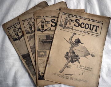
The SCOUT MAGAZINE Rare c1912 5 x Issues RARE!Luis Porretta Fine Arts4.3(10)See Sold PriceMar 02, 2024
Hasimoto Chikanobu, Japanese Woodblock PrintsWealthier Art & Auction4.6(283)See Sold PriceFeb 24, 2024
Willem Blaeu, Etc. 17th C. Antiquarian Maps, 2Auctions at Showplace4.6(744)See Sold PriceMar 17, 2024
Map: A 17thC engraved and hand coloured map of Scotland titled Strath-Navernia / Strath Navern afterClaydon Auctioneers Ltd4.3(125)See Sold PriceFeb 26, 2024
SOUTHERN AFRICA. Congo British/Portuguese/German East Africa Rhodesia 1912 mapJasper524.5(9.9k)See Sold PriceFeb 28, 2024
AFRICA shows 1911 Neukamerun border changes. Equatorial cross section 1912 mapJasper524.5(9.9k)See Sold PriceFeb 28, 2024
NORTH AFRICA. Morocco Algeria Tunis Tunisia Egypt. Cairo. BARTHOLOMEW 1912 mapJasper524.5(9.9k)See Sold PriceFeb 28, 2024
COLONIAL CENTRAL AFRICA. Kenya Tanzania Belgian Congo Angola. JOHNSTON 1912 mapJasper524.5(9.9k)See Sold PriceFeb 28, 2024
FRENCH WEST AFRICA Nigeria Gold Coast Rio de Oro Portuguese Guinea 1912 mapJasper524.5(9.9k)See Sold PriceFeb 28, 2024
Henri Romagnesi (1912 - 1999) - Set of 8 Mushroom Prints - Rhodophyllus - Entoloma sinuatum -Proverde Auctions4.3(3)See Sold PriceFeb 28, 2024
Henri Romagnesi (1912 - 1999) - Set of 8 Mushroom Prints - Rhodophyllus - Inocybe aeruginascensProverde Auctions4.3(3)See Sold PriceFeb 28, 2024
Von Wright brothers - Set of 12 Bird Prints - Aria Grylle - Harelda Hyemalis - AnasProverde Auctions4.3(3)See Sold PriceFeb 28, 2024
Carl Johan Billmark - Set of 4 Prints depicting Rome, Italy - Church in Sweden - Views of EuropeProverde Auctions4.3(3)See Sold PriceFeb 28, 2024
Robert de Vaugondy - Map of Canada - Mer de l' Ouest or Sea of the West and a Northwest PassageProverde Auctions4.3(3)See Sold PriceFeb 28, 2024
Francis McNally - Antique Map of Ohio, Indiana & KentuckyProverde Auctions4.3(3)See Sold PriceFeb 28, 2024


![[Blaeu (Johan & Willem)] Cyprus Insula (1 of 1)](https://p1.liveauctioneers.com/410/10165/2289091_1_x.jpg?height=282&quality=70)