ATLAS of ANTIENT GEOGRAPHY by SAMUEL BUTLER 1843John McInnis Auctioneers,LLC4.6(504)See Sold PriceFeb 25, 2024
18TH C. ANTIQUE MAP: FRENCH & INDIAN WAR, FRAMEDThomaston Place Auction Galleries4.4(389)See Sold PriceFeb 24, 2024
Rand McNally Railroad Map Cabinet w/ 21 Railroad MapsRail & Road Auctions4.6(165)See Sold PriceMar 08, 2024
Keith Haring - Ink on New York Map, Best Buddies, Inscribed, Signed, and DatedSapphire Auction Gallery4.1(67)See Sold PriceMar 02, 2024
LATE 17TH C. FRENCH MAP OF THE NEW WORLD BY ALEXIS-HUBERT JAILLOT (1632-1712)Thomaston Place Auction Galleries4.4(389)See Sold PriceFeb 24, 2024
Central Railroad of New Jersey Map of Sandy Hook Route-ca. 1903JM Hobby Supply and Railroad Artifact Auctions4.4(126)See Sold PriceFeb 24, 2024
Lot of Six Mixed Atlas Box Cars-HO Scale-New in BoxJM Hobby Supply and Railroad Artifact Auctions4.4(126)See Sold PriceFeb 25, 2024
Rand McNally/Santa Fe Railroad Map of Iowa-1912JM Hobby Supply and Railroad Artifact Auctions4.4(126)See Sold PriceFeb 24, 2024
NICOLAES VISSCHER (NETHERLANDS, 1618-1709) MAP OF THE NEW WORLDThomaston Place Auction Galleries4.4(389)See Sold PriceFeb 24, 2024
17TH C. WORLD MAP BY NICOLAES VISSCHER (NETHERLANDS, 1618-1709)Thomaston Place Auction Galleries4.4(389)See Sold PriceFeb 24, 2024
Lot of Six Mixed Atlas Cabooses-HO Scale-New in BoxJM Hobby Supply and Railroad Artifact Auctions4.4(126)See Sold PriceFeb 25, 2024
Maps, Philadelphia: Centennial, Scull ReproA 1957 reproduction of an 1858 republication of the 1762 map of Philadelphia drawn by Nicholas Scull and published by Matthew Clarkson and Mary Biddle, printed by the the Society of Colonial Wars afteSee Sold Price
SoldAN EARLY ENGRAVED MAP OF PHILADELPHIA, NICHOLAS SCULL,AN EARLY ENGRAVED MAP OF PHILADELPHIA, NICHOLAS SCULL, 1762 To the Mayor, Recorder, Aldermen, Common Council and Freemen of Philadelphia this plan of the improved part of the city, surveyed and laid dSee Sold Price
SoldScull Map of Philadelphia, 1752SCULL, Nicholas (1687-1761) & HEAP, George (1714-1752). A Map of Philadelphia and Parts Adjacent. Engraved map with original hand color. London: 1752. 15" x 12 1/2" sheet; 19 3/4" x 17 1/4" framed. EaSee Sold Price
SoldScull Map of Philadelphia with Statehouse, 1752 on SilkSCULL, Nicholas (1687-1761) and HEAP, George (active 1715-1760). A Map of Philadelphia, and Parts Adjacent with a Perspective View of the State House. Engraved Map on silk. c. 1752. 21 1/2" x 12 3/4"See Sold Price
SoldScull and Heap Map - PhiladelphiaMap titled "A Map of Philadelphia and parts Adjacent" by N. Scull and G. Heap. Printed in the London Gentleman's Magazine, Feb 1777. Measures 14 1/2" x 12" and has been trimmed tight on both left andSee Sold Price
SoldThree Maps of PhiladelphiaLot of three maps of Philadelphia, including Fairmount Park Centennial area, the Philadelphia suburbs, etc. Various dates and publishers.See Sold Price
SoldScull & Heap Map of PhiladelphiaMap titled "A Map of Philadelphia and Parts Adjacent" by N. Scull and G. Heap. Map is matted and framed and measures 13 1/4" x 11 1/2" (sight) and exhibits evidence of folding. Shipping: $26 plus insuSee Sold Price
SoldNicholas Scull - A Map of PhiladelphiaNicholas Scull (1687-1762), [A Map of Philadelphia and Parts Adjacent, by N. Scull and G. Heap], London, 1752, surveyor, George Heap, black and white line engraving with period hand color on laid papeSee Sold Price
Sold5 Folding Maps of Philadelphia, 19th century incl5 Folding Maps of Philadelphia, 19th century including 1876 centennial map.-- Dimensions: ---See Sold Price
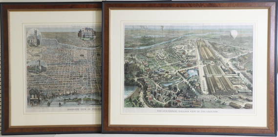
Antique View of Philadelphia Centennial Fair, 1876Title/Content of Map: 1876 Bird's Eye View of Philadelphia Centennial Fair and Exhibit -- Birds Eye View of the Centennial Buildings and Grounds Date Printed: 1876 Cartographer: H Toudy / National PubSee Sold Price
1876 Bird's Eye View of Philadelphia Centennial FairTitle/Content of Map: 1876 Bird's Eye View of Philadelphia Centennial Fair and Exhibit -- Birds Eye View of the Centennial Buildings and Grounds Date: 1876 Cartographer: H Toudy / National PublishingSee Sold Price
1876 Bird's Eye View of Philadelphia Centennial FairTitle/Content of Map: 1876 Bird's Eye View of Philadelphia Centennial Fair and Exhibit -- Birds Eye View of the Centennial Buildings and Grounds Date Printed: 1876 Cartographer: H Toudy / National PubSee Sold Price
1876 Bird's Eye View of Philadelphia Centennial FairTitle/Content of Map: 1876 Bird's Eye View of Philadelphia Centennial Fair and Exhibit -- Birds Eye View of the Centennial Buildings and Grounds Date: 1876 Cartographer: H Toudy / National PublishingSee Sold Price
1876 Bird's Eye View of Philadelphia Centennial FairTitle/Content of Map: 1876 Bird's Eye View of Philadelphia Centennial Fair and Exhibit -- Birds Eye View of the Centennial Buildings and Grounds Date: 1876 Cartographer: H Toudy / National PublishingSee Sold Price
1876 Bird's Eye View of Philadelphia Centennial FairTitle/Content of Map: 1876 Bird's Eye View of Philadelphia Centennial Fair and Exhibit -- Birds Eye View of the Centennial Buildings and Grounds Date: 1876 Cartographer: H Toudy / National PublishingSee Sold Price
1876 Bird's Eye View of Philadelphia Centennial FairTitle/Content of Map: 1876 Bird's Eye View of Philadelphia Centennial Fair and Exhibit -- Birds Eye View of the Centennial Buildings and Grounds Date: 1876 Cartographer: H Toudy / National PublishingSee Sold Price
1876 Bird's Eye View of Philadelphia Centennial FairTitle/Content of Map: 1876 Bird's Eye View of Philadelphia Centennial Fair and Exhibit -- Birds Eye View of the Centennial Buildings and Grounds Date: 1876 Cartographer: H Toudy / National PublishingSee Sold Price
1876 Bird's Eye View of Philadelphia Centennial FairReserve Reduced! Title/Content of Map: 1876 Bird's Eye View of Philadelphia Centennial Fair and Exhibit -- Birds Eye View of the Centennial Buildings and Grounds Date: 1876 Cartographer: H Toudy / NatSee Sold Price
1876 Bird's Eye View of Philadelphia Centennial FairTitle/Content of Map: 1876 Bird's Eye View of Philadelphia Centennial Fair and Exhibit -- Birds Eye View of the Centennial Buildings and Grounds Cartographer: H Toudy / National Publishing Co. Year/PlSee Sold Price
SoldScull and Heap Map of PhiladelphiaA framed map of "Philadelphia and Parts Adjacent" by N. Scull and G. Heap. Framed under glass. Mat opening: 13-1/4in x 11-1/2in.See Sold Price
Scull and Heap Map of Philadelphia.Black and white engraved map by N. Scull and G. Heap of Philadelphia and parts adjacent. Map measures 15" x 13" and presents evidence of previous removal from book with loss at left border. Image exhiSee Sold Price
Sold18TH C. MAPS OF PHILADELPHIA & BOSTONMap of Philadelphia and parts adjacent, by N. Scull and G. Heap and Boston town plan and harbor chart; Hand-colored engravings (framed separately); Each: 12" x 14"See Sold Price
Sold"Urban (Sylvanus) - The Gentleman's Magazine, andVol XXIII, only, engraved plates, a few hand coloured, 3 folding maps, including N. Scull & G. Heap's map of Philadelphia, all trimmed, with very slight loss, Philadelphia also with small tape-repairSee Sold Price
SoldMap of Philadelphia c.1777Title: A Map of Philadelphia and Parts Adjacent, by N. Scull and G. Heap Author: Scull & Heap Description: Copper-engraved map. 34x30 cm. (13½x12").Oddly, the left neat line is not printed. Heading:See Sold Price
1849 Mitchell School ATLAS 24 MAPS America Holy Land France Africa Egypt AsiaSchilb Antiquarian Rare Books4.8(422)See Sold PriceMar 31, 2024
1876 The Centennial Exhibition Pennsylvania Railroad Worlds Fair Guide with Map and Trade CardRail & Road Auctions4.6(165)See Sold PriceMar 07, 2024
Mitchell - Map of the City of Washington (Washington, DC)Trillium Antique Prints & Rare Books4.5(30)See Sold PriceFeb 24, 2024
Carey, pub. 1796 - Map of the State of MarylandTrillium Antique Prints & Rare Books4.5(30)See Sold PriceFeb 24, 2024
Carey, pub. 1796 - Map of GeorgiaTrillium Antique Prints & Rare Books4.5(30)See Sold PriceFeb 24, 2024
Carey, pub. 1796 - Map of The State of South CarolinaTrillium Antique Prints & Rare Books4.5(30)See Sold PriceFeb 24, 2024
Carey, pub. 1796 - Map of KentuckyTrillium Antique Prints & Rare Books4.5(30)See Sold PriceFeb 24, 2024
Carey, pub. 1796 - Map of the Tennassee State formerly part of North Carolina (Tennessee)Trillium Antique Prints & Rare Books4.5(30)See Sold PriceFeb 24, 2024
Antique Primitive Firkin, marked "Our Centennial Best 1775 - 1875".Westside Traders Emporium4.5(34)See Sold PriceFeb 27, 2024
1829 GERMAN-LANGUAGE ANTIQUE AMERICAN BIBLE ILLUSTRATED WITH MAPS OF PHILADELPHIANY Elizabeth 4.3(85)See Sold PriceMar 03, 2024
Framed Vintage Style Visscher Commander Repro MapRapid Estate Liquidators and Auction Gallery4.5(1.1k)See Sold PriceMar 01, 2024
Pair of Philadelphia Woodcut Engravings From Harper's WeeklyAlderfer Auction4.6(710)$300244 Lots Away