ATLAS of ANTIENT GEOGRAPHY by SAMUEL BUTLER 1843John McInnis Auctioneers,LLC4.6(502)See Sold PriceFeb 24, 2024
18TH C. ANTIQUE MAP: FRENCH & INDIAN WAR, FRAMEDThomaston Place Auction Galleries4.4(386)See Sold PriceFeb 24, 2024
Rand McNally Railroad Map Cabinet w/ 21 Railroad MapsRail & Road Auctions4.6(165)See Sold PriceMar 08, 2024
Keith Haring - Ink on New York Map, Best Buddies, Inscribed, Signed, and DatedSapphire Auction Gallery4(67)See Sold PriceMar 02, 2024
LATE 17TH C. FRENCH MAP OF THE NEW WORLD BY ALEXIS-HUBERT JAILLOT (1632-1712)Thomaston Place Auction Galleries4.4(386)See Sold PriceFeb 24, 2024
Central Railroad of New Jersey Map of Sandy Hook Route-ca. 1903JM Hobby Supply and Railroad Artifact Auctions4.4(126)See Sold PriceFeb 24, 2024
Lot of Six Mixed Atlas Box Cars-HO Scale-New in BoxJM Hobby Supply and Railroad Artifact Auctions4.4(126)See Sold PriceFeb 25, 2024
Rand McNally/Santa Fe Railroad Map of Iowa-1912JM Hobby Supply and Railroad Artifact Auctions4.4(126)See Sold PriceFeb 24, 2024
NICOLAES VISSCHER (NETHERLANDS, 1618-1709) MAP OF THE NEW WORLDThomaston Place Auction Galleries4.4(386)See Sold PriceFeb 24, 2024
17TH C. WORLD MAP BY NICOLAES VISSCHER (NETHERLANDS, 1618-1709)Thomaston Place Auction Galleries4.4(386)See Sold PriceFeb 24, 2024
Lot of Six Mixed Atlas Cabooses-HO Scale-New in BoxJM Hobby Supply and Railroad Artifact Auctions4.4(126)See Sold PriceFeb 25, 2024
1826 Hall Map of Northern Africa -- Africa AntiquaTitle/Content of Map: 1826 Hall Map of Northern Africa -- Africa Antiqua Date: 1826, London Cartographer: S Hall Size: 7.3 X 9.5 in. A very nice map of Northen Africa, including the Sahara, topographiSee Sold Price
1826 Hall Map of Northern Africa -- Africa AntiquaTitle/Content of Map: 1826 Hall Map of Northern Africa -- Africa Antiqua Date: 1826, London Cartographer: S Hall Size: 7.3 X 9.5 in. A very nice map of Northen Africa, including the Sahara, topographiSee Sold Price
1826 Hall Map of Northern Africa -- Africa AntiquaReserve Reduced! Title/Content of Map: 1826 Hall Map of Northern Africa -- Africa Antiqua Date: 1826, London Cartographer: S Hall Size: 7.3 X 9.5 in. A very nice map of Northen Africa, including the SSee Sold Price
1826 Hall Map of Northern Africa -- Africa AntiquaTitle/Content of Map: 1826 Hall Map of Northern Africa -- Africa Antiqua Date: 1826, London Cartographer: S Hall Size: 7.3 X 9.5 in. A very nice map of Northen Africa, including the Sahara, topographiSee Sold Price
1826 Hall map of Northern Africa -- Mauritania,Title/Content of Map: 1826 Hall map of Northern Africa -- Mauritania, Numidia, et Africa Propria Date: 1826, London Cartographer: S Hall Size: 7.4 X 9.6 in. A very nice map of Northern Africa from todSee Sold Price
1826 Hall map of Northern Africa -- Mauritania,Reserve Reduced! Title/Content of Map: 1826 Hall map of Northern Africa -- Mauritania, Numidia, et Africa Propria Date: 1826, London Cartographer: S Hall Size: 7.4 X 9.6 in. A very nice map of NortherSee Sold Price
Sold1798 Wilkinson Map of Northern Africa in Ancient TimesTitle: 1798 Wilkinson Map of Northern Africa in Ancient Times -- Africa Antiqua Date: 1798, London Medium: R Wilkinson Size: 7.9 X 11.1 in. Additional Information: This is an attractive map Northern ASee Sold Price
SoldNorthern Africa: 4 maps, 1825-1842. Color & col O[Africa, Northern]. 5 engraved maps, mostly outline color, double-page except first one. Very good condition unless noted. ++ 2 copies: Ludwig Vivien. Aegyptus Antiqua, Ad Tempora Romana. Paris: MenarSee Sold Price
Sidney Hall: Map of Northern Africa 1830Map: Northern Africa Maker: Longman, Rees, Orme, Brown and Green, Hall, Sidney Publication Date: 1830 Publisher: Longman, Rees, Orme, Brown and Green Size: Folio – 16.50 H x 20.00 W Inches Water staSee Sold Price
1840 SDUK Map of Northern Africa -- Ancient Africa orReserve Reduced! Title/Content of Map: 1840 SDUK Map of Northern Africa -- Ancient Africa or Libya Part II Date: 1840, London Cartographer: SDUK Size: 12.1 x 15.6 in This is a superb map of Northern ASee Sold Price
1840 SDUK Map of Northern Africa -- Ancient Africa orTitle/Content of Map: 1840 SDUK Map of Northern Africa -- Ancient Africa or Libya Part II Cartographer: SDUK Year/Place: 1840, London Size: 12.1 x 15.6 in This is a superb map of Northern Africa in paSee Sold Price
1840 SDUK Map of Northern Africa -- Ancient Africa orTitle: 1840 SDUK Map of Northern Africa -- Ancient Africa or Libya Part II Cartographer: SDUK Year / Place: 1840, London Map Dimension (in.): 12.1 x 15.6 in This is a superb map of Northern Africa inSee Sold Price
1840 SDUK Map of Northern Africa -- Ancient Africa or Libya Part IITitle: 1840 SDUK Map of Northern Africa -- Ancient Africa or Libya Part II Cartographer: SDUK Year / Place: 1840, London Map Dimension (in.): 12.1 x 15.6 in This is a superb map of Northern Africa inSee Sold Price
1840 SDUK Map of Northern Africa -- Ancient Africa orTitle/Content of Map: 1840 SDUK Map of Northern Africa -- Ancient Africa or Libya Part II Date Printed: 1840, London Cartographer: SDUK Size: 12.1 x 15.6 in This is a superb map of Northern Africa inSee Sold Price
1840 SDUK Map of Northern Africa -- Ancient Africa orTitle: 1840 SDUK Map of Northern Africa -- Ancient Africa or Libya Part II Date: 1840, London Cartographer: SDUK Size: 12.1 x 15.6 in Additional Information: This is a superb map of Northern Africa inSee Sold Price
1840 SDUK Map of Northern Africa -- Ancient Africa orTitle/Content of Map: 1840 SDUK Map of Northern Africa -- Ancient Africa or Libya Part II Date: 1840, London Cartographer: SDUK Size: 12.1 x 15.6 in This is a superb map of Northern Africa in part, shSee Sold Price
1840 SDUK Map of Northern Africa -- Ancient Africa orReserve Reduced! Title/Content of Map: 1840 SDUK Map of Northern Africa -- Ancient Africa or Libya Part II Date: 1840, London Cartographer: SDUK Size: 12.1 x 15.6 in This is a superb map of Northern ASee Sold Price
1840 SDUK Map of Northern Africa -- Ancient Africa orTitle/Content of Map: 1840 SDUK Map of Northern Africa -- Ancient Africa or Libya Part II Date: 1840, London Cartographer: SDUK Size: 12.1 x 15.6 in This is a superb map of Northern Africa in part, shSee Sold Price
1840 SDUK Map of Northern Africa -- Ancient Africa orTitle/Content of Map: 1840 SDUK Map of Northern Africa -- Ancient Africa or Libya Part II Date: 1840, London Cartographer: SDUK Size: 12.1 x 15.6 in This is a superb map of Northern Africa in part, shSee Sold Price
CHARLES ROLLIN c1828 Ceasar Hand Colored Africa Military MapLuis Porretta Fine Arts4.3(10)See Sold PriceMar 02, 2024
De Jode, Rare, pub. 1593 - Map of Africa (Africae Vera Forma, et Situs)Trillium Antique Prints & Rare Books4.5(30)See Sold PriceFeb 24, 2024
NORTHERN AFRICA. Morocco Tunisia Algeria. Caravan routes. RAPKIN/TALLIS 1851 mapJasper524.5(9.8k)See Sold PriceFeb 28, 2024
WEST AFRICA Explorers' routes Senegal Ashanti. Mountains of Kong. SDUK 1857 mapJasper524.5(9.8k)See Sold PriceFeb 28, 2024
AFRICA. Antiqua; Rome Carthage, start Punic War 1908 old antique map chartJasper524.5(9.8k)See Sold PriceFeb 28, 2024
Pre-colonial Africa. Mountains of Kong/Moon. Caravan routes. THOMSON 1817 mapJasper524.5(9.8k)See Sold PriceFeb 28, 2024
Northern & Southern Africa. Maghreb. Orange River Sovereignty. HALL 1854 mapJasper524.5(9.8k)See Sold PriceFeb 28, 2024
NORTH AFRICA BARBARY. Parts of Tripoli (Libya) & Egypt. Tribes. SDUK 1844 mapJasper524.5(9.8k)See Sold PriceFeb 28, 2024
NORTH AFRICA. 'Biledulgerid', a former North African country. MALLET 1683 mapJasper524.5(9.8k)See Sold PriceFeb 28, 2024
Early colonial Africa. Inset Madeira & Aden. SIDNEY HALL 1856 old antique mapJasper524.5(9.8k)See Sold PriceFeb 28, 2024
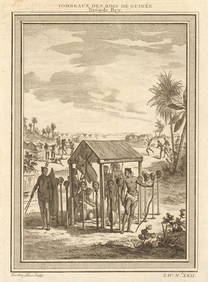
West Africa. Shrines of the Kings of Guinea, from Bry. Heads on stakes 1747Jasper524.5(9.8k)See Sold PriceFeb 28, 2024
Afrique. Pays des Hottentots #50. Namibia South Africa VANDERMAELEN 1827 mapJasper524.5(9.8k)See Sold PriceFeb 28, 2024
Northern & Southern Africa. Maghreb. Orange River Sovereignty. HALL 1856 mapJasper524.5(9.8k)See Sold PriceFeb 28, 2024
North & West Africa. Dahomey. Gold Coast. Military Territory. THE TIMES 1922 mapJasper524.5(9.8k)See Sold PriceFeb 28, 2024
Afrique. Pays des Hottentots #51. Botswana South Africa. VANDERMAELEN 1827 mapJasper524.5(9.8k)See Sold PriceFeb 28, 2024
NIGERIA early explorers' routes. Lake Chad. Yariba Houssa Borgou SDUK 1844 mapJasper524.5(9.8k)See Sold PriceFeb 28, 2024
Early colonial Africa. Inset Madeira & Aden. SIDNEY HALL 1854 old antique mapJasper524.5(9.8k)See Sold PriceFeb 28, 2024
NIGERIA w/ early explorers' routes. Lake Chad Yariba Houssa Borgou.SDUK 1844 mapJasper524.5(9.8k)See Sold PriceFeb 28, 2024
NORTHERN AFRICA. Morocco Tunisia Algeria. Caravan routes.TALLIS/RAPKIN 1851 mapJasper524.5(9.8k)See Sold PriceFeb 28, 2024
NORTHERN AFRICA. Morocco Tunisia Algeria. Caravan routes. RAPKIN/TALLIS 1851 mapJasper524.5(9.8k)See Sold PriceFeb 28, 2024