ATLAS of ANTIENT GEOGRAPHY by SAMUEL BUTLER 1843John McInnis Auctioneers,LLC4.6(502)See Sold PriceFeb 24, 2024
18TH C. ANTIQUE MAP: FRENCH & INDIAN WAR, FRAMEDThomaston Place Auction Galleries4.4(386)See Sold PriceFeb 24, 2024
Rand McNally Railroad Map Cabinet w/ 21 Railroad MapsRail & Road Auctions4.6(165)See Sold PriceMar 08, 2024
Keith Haring - Ink on New York Map, Best Buddies, Inscribed, Signed, and DatedSapphire Auction Gallery4(67)See Sold PriceMar 02, 2024
LATE 17TH C. FRENCH MAP OF THE NEW WORLD BY ALEXIS-HUBERT JAILLOT (1632-1712)Thomaston Place Auction Galleries4.4(386)See Sold PriceFeb 24, 2024
Central Railroad of New Jersey Map of Sandy Hook Route-ca. 1903JM Hobby Supply and Railroad Artifact Auctions4.4(126)See Sold PriceFeb 24, 2024
Lot of Six Mixed Atlas Box Cars-HO Scale-New in BoxJM Hobby Supply and Railroad Artifact Auctions4.4(126)See Sold PriceFeb 25, 2024
Rand McNally/Santa Fe Railroad Map of Iowa-1912JM Hobby Supply and Railroad Artifact Auctions4.4(126)See Sold PriceFeb 24, 2024
NICOLAES VISSCHER (NETHERLANDS, 1618-1709) MAP OF THE NEW WORLDThomaston Place Auction Galleries4.4(386)See Sold PriceFeb 24, 2024
17TH C. WORLD MAP BY NICOLAES VISSCHER (NETHERLANDS, 1618-1709)Thomaston Place Auction Galleries4.4(386)See Sold PriceFeb 24, 2024
Lot of Six Mixed Atlas Cabooses-HO Scale-New in BoxJM Hobby Supply and Railroad Artifact Auctions4.4(126)See Sold PriceFeb 25, 2024
Carte Des Isles De La Societe Decouvertes...[Cook’s 1st Voyage] Carte Des Isles De La Societe Decouvertes Par Le Lieutt. J Cook. 1769. Folding map after Capt. James Cook showing the Society Islands, discovered on his first voyage. Plate 1 froSee Sold Price
SoldCarte Des Isles De La Societé... J. Cook. 1769.[Oceania] Carte Des Isles De La Societé découvertes Par Le Lieutt. J. Cook. Paris, 1774. Detailed map of the Society Islands, based upon the contemporary surveys of Captain James Cook during his firSee Sold Price
Map Of Captain Cook's VoyagesCarte Des Isles De La Societe 10 1/2" x 13 1/2" (sight) Rigorbet Bonne, 1775See Sold Price
SoldIsles de la Société. Society Islands. Huaheine RaiateaTITLE/CONTENT OF MAP: '[Cook 3e Voyage] Carte des Isles de la Société // Isle de Noël // Havre d'Owarre dans Huaheine // Havre d'Oopoa dans Ulietea // Havre d'Ohamaneno dans Ulietea [Cook's 3rd VoySee Sold Price
SoldMap of the Society Islands, 1787Heading: Author: Bonne, Rigobert Title: Carte des Isles de la Societé Place Published: Paris Publisher: Date Published: 1787 Description: Copper-engraved map, later hand-coSee Sold Price
Carte des Isles Sandwich. Hawaiian Islands & KealakekuaTITLE/CONTENT OF MAP: '[Cook 3e Voyage] Carte des Isles Sandwich // Plan de la Baye de Karakakooa [Cook's 3rd Voyage - Map of the Sandwich (Hawaiian) Islands // Map of Kealakekua Bay]' DATE PRINTED: 1See Sold Price
Carte des Isles Sandwich. Hawaiian Islands & KealakekuaTITLE/CONTENT OF MAP: '[Cook 3e Voyage] Carte des Isles Sandwich // Plan de la Baye de Karakakooa [Cook's 3rd Voyage - Map of the Sandwich (Hawaiian) Islands // Map of Kealakekua Bay]' DATE PRINTED: 1See Sold Price
Carte des Isles Sandwich. Hawaiian Islands & KealakekuaTITLE/CONTENT OF MAP: [Cook 3e Voyage] Carte des Isles Sandwich // Plan de la Baye de Karakakooa [Cook's 3rd Voyage - Map of the Sandwich (Hawaiian) Islands // Map of Kealakekua Bay] DATE PRINTED: 179See Sold Price
Carte des Isles Sandwich. Hawaiian Islands & KealakekuaTITLE/CONTENT OF MAP: [Cook 3e Voyage] Carte des Isles Sandwich // Plan de la Baye de Karakakooa [Cook's 3rd Voyage - Map of the Sandwich (Hawaiian) Islands // Map of Kealakekua Bay] The top image onSee Sold Price
Carte des Isles Sandwich. Hawaiian Islands & KealakekuaTITLE/CONTENT OF MAP: '[Cook 3e Voyage] Carte des Isles Sandwich // Plan de la Baye de Karakakooa [Cook's 3rd Voyage - Map of the Sandwich (Hawaiian) Islands // Map of Kealakekua Bay]' The top image oSee Sold Price
Carte des Isles Sandwich. Hawaiian Islands & KealakekuaTITLE/CONTENT OF MAP: '[Cook 3e Voyage] Carte des Isles Sandwich // Plan de la Baye de Karakakooa [Cook's 3rd Voyage - Map of the Sandwich (Hawaiian) Islands // Map of Kealakekua Bay]' DATE PRINTED: 1See Sold Price
Carte des Isles Sandwich. Hawaiian Islands & KealakekuaTITLE/CONTENT OF MAP: [Cook 3e Voyage] Carte des Isles Sandwich // Plan de la Baye de Karakakooa [Cook's 3rd Voyage - Map of the Sandwich (Hawaiian) Islands // Map of Kealakekua Bay] The top image onSee Sold Price
Carte des Isles Sandwich. Hawaiian Islands & KealakekuaTITLE/CONTENT OF MAP: '[Cook 3e Voyage] Carte des Isles Sandwich // Plan de la Baye de Karakakooa [Cook's 3rd Voyage - Map of the Sandwich (Hawaiian) Islands // Map of Kealakekua Bay]' DATE PRINTED: 1See Sold Price
SoldJames Cook Chart of Tahiti c.1780Title: Carte de l'Isle de Taiti, par Lieutenant J. Cook 1769 Author: Cook, James Description: Copper-engraved chart/map, modern hand-coloring. 23.4x40 cm. (9¼x15¾").Well-engraved map of Tahiti as chSee Sold Price
SoldJames Cook Chart of Tahiti c.1780Title: Carte de l'Isle de Taiti, par Lieutenant J. Cook 1769 Author: Cook, James Description: Copper-engraved chart/map. 23.4x40 cm. (9¼x15¾"), hinged to mat.Well-engraved map of Tahiti as charted bSee Sold Price
James Cook Chart of Tahiti c.1780Title: Carte de l'Isle de Taiti, par Lieutenant J. Cook 1769 Author: Cook, James Description: Copper-engraved chart/map. 23.4x40 cm. (9¼x15¾"), hinged to mat.Well-engraved map of Tahiti as charted bSee Sold Price
SoldCarte de l'Isle de Taiti'. Island of Tahiti. COOK /TITLE/CONTENT OF MAP: 'Carte de l'Isle de Taiti , par le Lieutenant J. Cook 1769 [Map of the Island of Tahiti by Lieutenant J. Cook 1769]' DATE PRINTED: 1789 IMAGE SIZE: Approx 25.0 x 41.5cm, 9.75 x 1See Sold Price
Benard, R. Carte de la N. Zelande visitee par J. CookBenard, Robert Carte de la N.le.Zelande visitee en 1769, et 1770 par le Lieutenant J. Cook 1774 Copperplate engraving; area coloured Printed area: 53.3 x 39.7 cm; 20.9 x 15.6 in Created by Robert BenaSee Sold Price
SoldBellin (J N) Chart of the coast of CantonBellin (J.N.) Carte des Isles qui sont a l'Embouchure de la Riviere de Canton, the coast of China, with decorative title cartouche and compass rose, engraved chart, with original hand-colourinSee Sold Price
Sold3pc 18th Century Maps of Macao & Islands- Cook etc3pc 18th Century Maps of Macao & Islands. Includes J.V. Schley 'Carte des Isles de le Riviere de Canton' c. 1750 (11.25x15''), James Cook 'Sketch Typa and Macao' 1785 (11.25x9''), and Nicolas Bellin 'See Sold Price
SoldBellin (J N) Carte des Isles ...CantonBellin (Jacques Nicolas) Carte des Isles qui sont a l'Embouchure de la Riviere de Canton,southern China, part of Quang Tong province, and Macau, with decorative title cartouche, and compass roSee Sold Price
Bellin.Carte des Isles..Riviere de Canton,1756Maps.- Bellin (J.N.) Carte des Isles qui sont a l'Embouchure de la Riviere de Canton, the coast of China, with decorative title cartouche and compass rose, engraved chart, with original hand-See Sold Price
Bellin Map of Saint Pierre and MiquelonCarte des Isles de Miquelon et de St Pierre et de la Coste de Terre-Neuve Voisine. J. N. Bellin, 1764. Image 9" x 6.5" / 23 cm x 16.5 cm.See Sold Price
1773 Bellin Map of Japan, Korea and Coastal China --Title: 1773 Bellin Map of Japan, Korea and Coastal China -- Carte des Isles du Japon et la Presqu Isle de Coree avec les Costes de la Chine Depuis Pekin Jusqua Canton Cartographer: J Bellin Year / PlaSee Sold Price
Charles Emile Jacque (French 1813-1894) Etching on laid paper Portrait M.J LuqueGlobal Auctions Company4.3(36)See Sold PriceMar 03, 2024
Pierre LE FAGUAYS (1892-1962) Rare "Jeune fille aux Poupees" lampGOLDFIELD AUCTION4.3(32)See Sold PriceMar 02, 2024
[MAPS]. DUFOUR, Auguste-Henri (1795-1865). Bound Volume of ...Potter & Potter Auctions4.6(539)See Sold PriceMar 07, 2024
Map of St. Kitts and Nevis Depot de la Marine, Paris, 1758Global Auctions Company4.3(36)See Sold PriceMar 03, 2024
Duval - Pair: Map of Georgia & Map of Moscow, RussiaTrillium Antique Prints & Rare Books4.5(30)See Sold PriceFeb 24, 2024
Duval - Pair: Map of India & Map of MaldivesTrillium Antique Prints & Rare Books4.5(30)See Sold PriceFeb 24, 2024
Railways & Transport.- [Prospectus] The Dorking, Brighton, and Arundel Atmospheric Railway, byForum Auctions4.3(52)See Sold PriceFeb 29, 2024
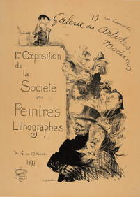
Charles Leandre - Les Maitres de l'Affiche : 1ere Exposition de la Societe des PeintresNCAG4.4(32)See Sold PriceMar 10, 2024
1764 Bellin Map of Eastern Guadeloupe in the Lesser Antilles -- Partie Orientale de l'Isle de laJasper524.5(9.8k)See Sold PriceFeb 27, 2024
1764 Bellin Map of Mari-Galante Near Guadeloupe -- Carte de l'Isle de Mari-GalanteJasper524.5(9.8k)See Sold PriceFeb 27, 2024
1764 Bellin Map of St. Kitts -- Carte de l'Isle St. ChristopheJasper524.5(9.8k)See Sold PriceFeb 27, 2024
1764 Bellin Map of Western Guadeloupe in the Lesser Antilles -- Partie Occidentale de l'Isle de laJasper524.5(9.8k)See Sold PriceFeb 27, 2024
1764 Bellin Map of Antigua -- Carte de l'Isle d'Antigue Situee par la Latitude 17 Degres et par laJasper524.5(9.8k)See Sold PriceFeb 27, 2024
1845 Delisle/Bauche Map of Martinique -- Carte de l'Isle de la Martinique Colonie Francoise de l'uneJasper524.5(9.8k)See Sold PriceFeb 27, 2024
Georges Pierre Dutriac (French,1866-1958) oil paintingBroward Auction Gallery4.8(277)See Sold PriceMay 19, 2024
1890 Souvenirs des Guerres de Crimée et d'ItalieRapid Estate Liquidators and Auction Gallery4.5(1.1k)See Sold PriceFeb 29, 2024


![[MAPS]. DUFOUR, Auguste-Henri (1795-1865). Bound Volume of ... (1 of 2)](https://p1.liveauctioneers.com/928/318880/171361279_1_x.jpg?height=282&quality=70&version=1707501302)


![Railways & Transport.- [Prospectus] The Dorking, Brighton, and Arundel Atmospheric Railway, by (1 of 1)](https://p1.liveauctioneers.com/5458/319736/171654703_1_x.jpg?height=282&quality=70&version=1708010439)