ATLAS of ANTIENT GEOGRAPHY by SAMUEL BUTLER 1843John McInnis Auctioneers,LLC4.6(502)See Sold PriceFeb 24, 2024
18TH C. ANTIQUE MAP: FRENCH & INDIAN WAR, FRAMEDThomaston Place Auction Galleries4.4(386)See Sold PriceFeb 24, 2024
Rand McNally Railroad Map Cabinet w/ 21 Railroad MapsRail & Road Auctions4.6(165)See Sold PriceMar 08, 2024
Keith Haring - Ink on New York Map, Best Buddies, Inscribed, Signed, and DatedSapphire Auction Gallery4(67)See Sold PriceMar 02, 2024
LATE 17TH C. FRENCH MAP OF THE NEW WORLD BY ALEXIS-HUBERT JAILLOT (1632-1712)Thomaston Place Auction Galleries4.4(386)See Sold PriceFeb 24, 2024
Central Railroad of New Jersey Map of Sandy Hook Route-ca. 1903JM Hobby Supply and Railroad Artifact Auctions4.4(126)See Sold PriceFeb 24, 2024
Lot of Six Mixed Atlas Box Cars-HO Scale-New in BoxJM Hobby Supply and Railroad Artifact Auctions4.4(126)See Sold PriceFeb 25, 2024
Rand McNally/Santa Fe Railroad Map of Iowa-1912JM Hobby Supply and Railroad Artifact Auctions4.4(126)See Sold PriceFeb 24, 2024
NICOLAES VISSCHER (NETHERLANDS, 1618-1709) MAP OF THE NEW WORLDThomaston Place Auction Galleries4.4(386)See Sold PriceFeb 24, 2024
17TH C. WORLD MAP BY NICOLAES VISSCHER (NETHERLANDS, 1618-1709)Thomaston Place Auction Galleries4.4(386)See Sold PriceFeb 24, 2024
Lot of Six Mixed Atlas Cabooses-HO Scale-New in BoxJM Hobby Supply and Railroad Artifact Auctions4.4(126)See Sold PriceFeb 25, 2024
SoldGvulei Tziyon with a Map of the Land of Israel,Ma'alat Eretz Yisrael with elucidations on the verses about the Land of Israel and elucidations on the Sages' sayings which praise the Land of Israel. With a study of the borders of the Land of IsraelSee Sold Price
SoldGevulei Tziyon. Vilna, 1899. With a Map of the Land ofGevulei Tziyon, with a color map of the Land of Israel and the surrounding region "Landcarte fun Palestine," by R' Shabtai Moskowitz. Special copy with the rare leaf of approbations. The book deals wiSee Sold Price
G'vulei Zion - Vilnius, 1889 - Map of Eretz IsraelSefer G'vulei Zion, general view on the borders of Eretz Israel as explained on the second title page accompanied by a map of the Holy Land. By Shabtai Ya'akov of Etzkowitz. Printed by Avraham Zvi KatSee Sold Price
Sefer G'vulei Zion - Vilnius, 1889 - Map of Eretz"Sefer G'vulei Zion, general view on the borders of Eretz Israel as explained on the second title page with a map of the Holy Land" (Hebrew). By Shabtai Ya'akov of Metzkewitz. Printed by Avraham Zvi KSee Sold Price
SoldThe Borders of the Holy Land - Vilnius, 1899Sefer G'vulei Yisrael (The Borders of Israel), as explained on the second title page with a map of the Holy Land. By Shabtai Ya'akov of Etzkowitz. Vilnius, 1899. Between the first and second title pagSee Sold Price
Lithography Map Land of Israel and Jerusalem Holy SitesA map in lithographic print, after an original painting made by Rabi Hayim Solomon Pinia of Safed, circa 1875. The original map was printed on canvas in 1875. Before us is a black and white lithographSee Sold Price
SoldANTIQUE MAP OF HOLY LAND (ISRAEL) (1767), hand colored,ANTIQUE MAP OF HOLY LAND (ISRAEL) (1767), hand colored, 11.25''H x 8.75''W.See Sold Price
Antique Map Engraving Land of Israel Dutch Bible BookThe map depicts the western part of the land of Israel up to the Lebanon. Made by Visscher Stoopendaal. The map depicts the travels of the tribes and the Exodus after the parting of the Red Sea. AdditSee Sold Price
SoldFive geographical maps - the Land of Israel, Jerusalem,5 geographical maps - the Land of Israel, Jerusalem, and the Temple Mount. Various Puplishers, 19th century * TERRE SAINTE By A.H. Dufour. Paris 1843. 33x25 cm. * Palaestina. Map of the Land of IsraelSee Sold Price
SoldFive Geographic Maps - Etchings. Land of Israel and theFive geographic maps - etchings depicting the Land of Israel and the Asian continent - 18th and 19th centuries. * La Turchia D'Asia Venice 1784 hand-painted from the time of the printing. 40x33 cm. *See Sold Price
SoldFive Geographic Maps - Etchings. Land of Israel and theFive geographic maps - etchings depicting the Land of Israel and the Asian continent - 18th and 19th centuries. * La Turchia D'Asia Venice 1784 hand-painted from the time of the printing. 40x33 cm. *See Sold Price
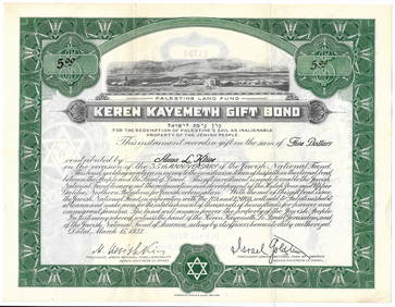
JNF/Jewish National Fund/KKL 1928 Map of Eretz IsraelJNF/Jewish National Fund (KKL) stamps & labels: Israel Head Office/Jerusalem pre-State issue, 1928 issue Map of Land of Israel 100m denominated embossed imperforated stamp in reddish brown on yellow pSee Sold Price
JNF/Jewish National Fund/KKL 1928 Map of Eretz IsraelJNF/Jewish National Fund (KKL) stamps & labels: Israel Head Office/Jerusalem pre-State issue, 1928 issue Map of Land of Israel 100m denominated embossed imperforated stamp in reddish brown on yellow pSee Sold Price
SoldTobias Conrad Lotter 19th C. Israel Holy Land MapTobias Conrad Lotter (German, 1717-1777). A 19th Century map of the Holy Land in its twelve tribal divisions, based on the work of Lotter, one of the best known 18th century German mapmakers. MeasuresSee Sold Price
SoldMap of the Holy Land. Israel. 1835.Print of hand colored steel engraving titled „Carte de la Terre Sainte.Author C. V. Monin.Engraved by unknown.From the „Atlas Universel de Geography by C. V. Monin. Parsi. 1835.The Holy Land as aSee Sold Price
SoldMap of the Land of Israel - Engraving - Venice, 1786Chorographia Tarrae Sancte in Angustiorem Formam Radacta, Et Ex Variis Auctoribus A Multis Erroribus Expurgata. Map of the Land of Israel - impressive engraving hand-painted (apparently, according toSee Sold Price
SoldAncient Palestine, A Map of the Land of Israel. AnA map of the Land of Israel in lithographic print, colored by hand by John Tallis, London 1851. On the sides of the map are pleasant cartouches: from left to right, Syrian roads, the entrance to JerusSee Sold Price
A Map of the Land of Israel, 1798Orignial engraved map by T. Conder. Published by C. Taylor, 1798. Showing the situation of those places which are mentioned by the Four Evangelists. Important placenames and routes of travel noted. DiSee Sold Price
Two Maps of the Land of Israel in Biblical Times – LondTwo Maps of the Land of Israel in Biblical Times – London.1. Canaan. Map of the Land of Israel as an aid to the study of Yehoshua and Shoftim. Published by Arrowsmith, engraved by S. Hall. London. 1See Sold Price
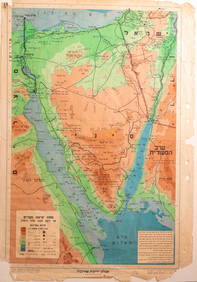
Map of the Land of Israel with Proposed BoundariesNew map of Palestine showing the proposed U. N. boundaries of Israel -Jewish and Arab towns, villages and settlements, plans of Tel Aviv, Jerusalem and Haifa, index of place names - under the guidanceSee Sold Price
Two Maps of the Land of Israel, 18th Century ...1. Iudaea, seu Terra Sancta quae Hebraeorum sive Israelitarum. Map of the Land of Israel on both banks of the Jordan River, showing the division of land among the tribes, by Guillaume Sanson. AmsterdaSee Sold Price
A Map of the Land of Israel, 1798Orignial engraved map by T. Conder. Published by C. Taylor, 1798. Showing the situation of those places which are mentioned by the Four Evangelists. Important placenames and routes of travel noted. DiSee Sold Price
A Map of the Land of Israel, 1798Orignial engraved map by T. Conder. Published by C. Taylor, 1798. Showing the situation of those places which are mentioned by the Four Evangelists. Important placenames and routes of travel noted. DiSee Sold Price
SoldMap of the Land of Israel. Venice, 1527. The FirstMap of the borders of the Land of Israel by Rabbi Eliyahu Mizrachi - the Re'em. Venice, at the Bomberg printing press, 1527, a leaf from Rabbi Eliyahu Mizrachi's supercommentary on Rashi's commentarySee Sold Price
Jewish National Fund Collection Box - Great BritainLevy Auction House4.3(11)See Sold PriceFeb 27, 2024
Eretz Israel Map Postcard - World Zionist OrganizationLevy Auction House4.3(11)See Sold PriceFeb 27, 2024
Collection of 10 Maps of Cities in Israel for TouristsLevy Auction House4.3(11)See Sold PriceFeb 27, 2024
Illustrated Sabbath Cloth - Holy Sites of Eretz IsraelLevy Auction House4.3(11)See Sold PriceFeb 27, 2024
1849 Mitchell School ATLAS 24 MAPS America Holy Land France Africa Egypt AsiaSchilb Antiquarian Rare Books4.8(421)See Sold PriceMar 31, 2024
1872 Holy BIBLE & Hitchcock Analysis Gruden Concordance Theology MAPS Holy LandSchilb Antiquarian Rare Books4.8(421)See Sold PriceMar 31, 2024
1886 Cities of BASHAN Holy Land SYRIA Palestine Israel Jerusalem History BibleSchilb Antiquarian Rare Books4.8(421)See Sold PriceMar 31, 2024
[MAPS]. DUFOUR, Auguste-Henri (1795-1865). Bound Volume of ...Potter & Potter Auctions4.6(539)See Sold PriceMar 07, 2024
A large silver handwashing vessel for the priests in the synagogue,Alma4.3(59)See Sold PriceMar 03, 2024
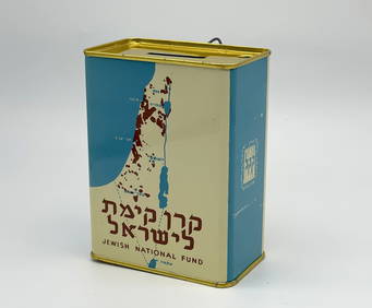
Alfred Salzman, Etc. JNF Tin Tzedakah Boxes, 3Auctions at Showplace4.5(726)See Sold PriceApr 07, 2024
Disney Art Prints and Old Epcot Discovery GuideRapid Estate Liquidators and Auction Gallery4.5(1.1k)See Sold PriceFeb 25, 2024
ANTIQUE 1686 OPERA OMNIA BY JOHN LIGHTFOOT TELLIMA BOUND FOLIO WITH ISRAEL MAPNY Elizabeth 4.3(84)See Sold PriceMar 03, 2024


![[MAPS]. DUFOUR, Auguste-Henri (1795-1865). Bound Volume of ... (1 of 2)](https://p1.liveauctioneers.com/928/318880/171361279_1_x.jpg?height=282&quality=70&version=1707501302)