ATLAS of ANTIENT GEOGRAPHY by SAMUEL BUTLER 1843John McInnis Auctioneers,LLC4.5(505)See Sold PriceFeb 25, 2024
18TH C. ANTIQUE MAP: FRENCH & INDIAN WAR, FRAMEDThomaston Place Auction Galleries4.4(393)See Sold PriceFeb 24, 2024
Rand McNally Railroad Map Cabinet w/ 21 Railroad MapsRail & Road Auctions4.6(165)See Sold PriceMar 08, 2024
Keith Haring - Ink on New York Map, Best Buddies, Inscribed, Signed, and DatedSapphire Auction Gallery4(67)See Sold PriceMar 02, 2024
LATE 17TH C. FRENCH MAP OF THE NEW WORLD BY ALEXIS-HUBERT JAILLOT (1632-1712)Thomaston Place Auction Galleries4.4(393)See Sold PriceFeb 24, 2024
Central Railroad of New Jersey Map of Sandy Hook Route-ca. 1903JM Hobby Supply and Railroad Artifact Auctions4.4(127)See Sold PriceFeb 24, 2024
Lot of Six Mixed Atlas Box Cars-HO Scale-New in BoxJM Hobby Supply and Railroad Artifact Auctions4.4(127)See Sold PriceFeb 25, 2024
Rand McNally/Santa Fe Railroad Map of Iowa-1912JM Hobby Supply and Railroad Artifact Auctions4.4(127)See Sold PriceFeb 24, 2024
NICOLAES VISSCHER (NETHERLANDS, 1618-1709) MAP OF THE NEW WORLDThomaston Place Auction Galleries4.4(393)See Sold PriceFeb 24, 2024
17TH C. WORLD MAP BY NICOLAES VISSCHER (NETHERLANDS, 1618-1709)Thomaston Place Auction Galleries4.4(393)See Sold PriceFeb 24, 2024
Lot of Six Mixed Atlas Cabooses-HO Scale-New in BoxJM Hobby Supply and Railroad Artifact Auctions4.4(127)See Sold PriceFeb 25, 2024
Bonne: Antique Map of Northeastern USA, 1780Title/Content of Map: 'Carte de la Partie Nord des Etats Unis de l'Amérique Septentrionale' A map of the northeastern United States: Mid-Atlantic States and New England Date Printed: 1780 Image Size:See Sold Price
Bonne: Antique Map of Northeastern USA, 1780Title/Content of Map: 'Carte de la Partie Nord des Etats Unis de l'Amérique Septentrionale' A map of the northeastern United States: Mid-Atlantic States and New England Date Printed: 1780 Image Size:See Sold Price
SoldFramed map, Rigobert Bonne, Northeastern US, 1787Framed handcolored map, Rigobert Bonne, Carte De La Partie Nord, Des Etats Unis, de l' Amerique Septentrionale, Northeastern United States, from Raynal's ''Atlas d.les Deux Indes'', Geneva, J.L. PelleSee Sold Price
(1778) Map Carte de la Partie Nord Des Etats UnisHistoric Maps(1778) Map titled, "Carte de la Partie Nord, Des Etats Unis, De L'Amerique Septentrionale," by M. Bonne, Extremely Fine. This original Map measures 9.5" x 14.25" and iSee Sold Price
SoldHand-colored Etats Unis Map, c.1780Historic MapsHand-colored "Etats Unis" Map c. 1780, "Carte de la Partie Nord, des Etats Unis de L'Amerique Septentrionale," M. Bonne, Choice Very Fine The 10.5" x 16.5" map depSee Sold Price
SoldHand-colored Etats Unis Map, c.1780MapsHand-colored “Etats Unis” Map c. 1780, “Carte de la Partie Nord, des Etats Unis de L'Amerique Septentrionale,” M. Bonne, Choice Very Fine The 10.5” x 16.5” mapSee Sold Price
SoldCarte de la Partie Nord, des Etats Unis...[North America/New England] CARTE DE LA PARTIE NORD, DES ETATS UNIS, DE L’AMERIQUE SEPTENTRIONALE, Par M. Bonne, Ingenieur Hydrographe de la marine. Folding map. [C. 1780.] “Liv. XVII et XVIII.”See Sold Price
SoldHand-colored Etats Unis Map, c.1780MapsHand-colored “Etats Unis,” Map c. 1780, “Carte de la Partie Nord, des Etats Unis de L'Amerique Septentrionale,” M. Bonne, Choice Very Fine The 10.5” x 16.5” mapSee Sold Price
SoldHand-colored Etats Unis Map, c.1780Historic MapsHand-colored "Etats Unis" Map c. 1780, "Carte de la Partie Nord, des Etats Unis de L'Amerique Septentrionale," M. Bonne, Choice Very Fine The 10.5" x 16.5" map depSee Sold Price
SoldNorthern part of new U.S. c.1783Title: Carte de la Partie Nord, des Etats Unis, de l'Amerique Septentrionale Author: Bonne, Rigobert Description: Copper-engraved map, later hand-coloring. 21x31.5 cm. (8½x12¼").The newly minted UniSee Sold Price
SoldHand-colored Etats Unis Map, c.1780Historic MapsHand-colored “Etats Unis” Map c. 1780, “Carte de la Partie Nord, des Etats Unis de L'Amerique Septentrionale,” M. Bonne, Choice Very Fine The 10.5” x 16.5&rdSee Sold Price
SoldNorthern United States c.1782Title: Carte de la Partie Nord, des Etats Unis, de l'Amerique Septentrionale Author: Bonne, Rigobert Description: Copper-engraved map. 21x32 cm. (8½x12½").Early map of the United States. From RaynalSee Sold Price
SoldHand-colored Etats Unis Map, c.1780Historic MapsHand-colored "Etats Unis" Map c. 1780, "Carte de la Partie Nord, des Etats Unis de L'Amerique Septentrionale," M. Bonne, Choice Very Fine The 10.5" x 16.5" map depSee Sold Price
Bonne: Antique Map of Northeast United States, 1780TITLE/CONTENT OF MAP: 'Carte de la Partie Nord des Etats Unis de l'Amérique Septentrionale' A map of the northeastern United States: Mid-Atlantic States and New England DATE PRINTED: 1780 IMAGE SIZE:See Sold Price
"Partie Nord des Etats Unis de l'AmériqueTITLE/CONTENT OF MAP: 'Carte de la Partie Nord des Etats Unis de l'Amérique Septentrionale' A map of the northeastern United States: Mid-Atlantic States and New England DATE PRINTED: 1780 IMAGE SIZE:See Sold Price
1785 AND 1730 ENGRAVED MAPSCARTE DE LA PARTIE NORD, DES ETATS UNIS, DE L'AMERIQUE SEPTENTRIONALE. R. BONNE. PARIS. 1785. Map of early U.S. Northeast, shortly after the Treaty of Paris created the U.S.A. Shows forts Duquesne, NeSee Sold Price
Lot of 3 copper-engraved maps by BonneTitle: Lot of 3 maps of America by Bonne Author: Bonne, Rigobert Description: Includes: Carte de la Partie Nord, des Etats Unis, de l'Amerique Septentrionale. * Le Nouveau Mexique, avec la Partie SeptSee Sold Price
SoldMAP OF NEW ENGLANDMAP OF NEW ENGLAND Carte de la partie Nord, Des Etats Unis de L’Amerique Septentrionale, par M. Bronne, Ingenieur Hydrographe de la Marine Worldwide shipping available. Contact shipping@sheppards.ieSee Sold Price
SoldNorthern part of new U.S. c.1783Title: Carte de la Partie Nord, des Etats Unis, de l'Amerique Septentrionale Author: Bonne, Rigobert Description: Copper-engraved map. 21x31.5 cm. (8½x12¼").The newly minted United States from the CSee Sold Price
Sold1800 Weld Map of Northern United States and Great LakesTitle: 1800 Weld Map of Northern United States and Great Lakes -- Partie des Etats-Unis de L'Amerique Septentrionale Cartographer: I Weld Year / Place: 1800, Paris Map Dimension (in.): 16.1 X !8.2 in.See Sold Price
Sold2 United States maps2 United States maps 1). ''Partie des Etats Unis de l'Amerique Septrionale''- from I. Weld Jrs.- 'Voyage au Canada dans les annees 1795, 1796 and 1797', French edition with faint original outline coloSee Sold Price
Partie Nord des Etats Unis de l'Amérique SeptentrionaleTITLE/CONTENT OF MAP: 'Carte de la Partie Nord des Etats Unis de l'Amérique Septentrionale' A map of the northeastern United States: Mid-Atlantic States and New England The top image on the right hSee Sold Price
SoldFrench Map of Southeastern"United States [Carte De la Partie Sud Des Etats Unis De L'Amerique Septentrionale,] Rigobert Bonne (French, 1727-1795), Paris, circa 1780, engraving on laid paper, hand-colored in outline, 8-3/4 x 13See Sold Price
Bonne: Antique Map of the Carolinas, 1780Title/Content of Map: 'Carte de la Partie Sud des Etats Unis de l'Amérique Septentrionale' A map of the Carolinas & Georgia Date Printed: 1780 Image Size: Approx 23.0 x 34.0cm, 9 x 13.5 inches (LargeSee Sold Price
LATE 17TH C. FRENCH MAP OF THE NEW WORLD BY ALEXIS-HUBERT JAILLOT (1632-1712)Thomaston Place Auction Galleries4.4(393)See Sold PriceFeb 24, 2024
LARGE EARLY 18TH C. DUTCH CHART OF UPPER NORTH AMERICA, PIERRE MORTIER (1661-1711), FRAMEDThomaston Place Auction Galleries4.4(393)See Sold PriceFeb 24, 2024
AMBROISE TARDIEU c1822 Napoleonic War Map GermanyLuis Porretta Fine Arts4.3(10)See Sold PriceMar 02, 2024
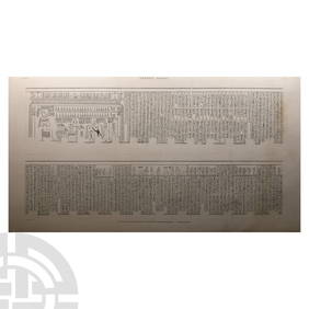
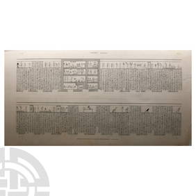
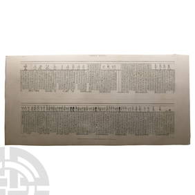
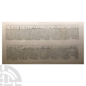
Large Egyptian Expedition Lithograph Print with HieroglyphsTimeLine Auctions Ltd.4.6(183)See Sold PriceMar 06, 2024
Large Egyptian Expedition Lithograph Print with HieroglyphsTimeLine Auctions Ltd.4.6(183)See Sold PriceMar 06, 2024
Large Egyptian Expedition Lithograph Print with HieroglyphsTimeLine Auctions Ltd.4.6(183)See Sold PriceMar 06, 2024
Numismatic Books - Miscellanea Numismatique 1872-1891TimeLine Auctions Ltd.4.6(183)See Sold PriceMar 09, 2024
ENFILADE en bois partiellement peint en noir ouvrant en façade par deux vantaux sur la partieValoir Pousse-Cornet4.3(4)See Sold PriceFeb 24, 2024
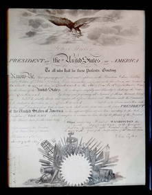
TYLER, John, 10e président des États-Unis d’Amérique / 10th President of theIEGOR Auctions4.2(135)See Sold PriceFeb 28, 2024
1758 MAP PARTIE DE LA MER GLACIALE contenants La Nouvelle Zemble RUSSIA antiqueJasper524.5(9.9k)See Sold PriceFeb 28, 2024
1845 Delisle/Bauche Map of Martinique -- Carte de l'Isle de la Martinique Colonie Francoise de l'uneJasper524.5(9.9k)See Sold PriceFeb 28, 2024
Partie Occidentale de l’Afrique. West Africa coast Canary islands BONNE 1788 mapJasper524.5(9.9k)See Sold PriceFeb 28, 2024


![[PRIZE OF WAR] : (1 of 6)](https://p1.liveauctioneers.com/1458/320148/172030900_1_x.jpg?height=282&quality=70&version=1708367366)


