ATLAS of ANTIENT GEOGRAPHY by SAMUEL BUTLER 1843John McInnis Auctioneers,LLC4.6(502)See Sold PriceFeb 24, 2024
18TH C. ANTIQUE MAP: FRENCH & INDIAN WAR, FRAMEDThomaston Place Auction Galleries4.4(386)See Sold PriceFeb 24, 2024
Rand McNally Railroad Map Cabinet w/ 21 Railroad MapsRail & Road Auctions4.6(165)See Sold PriceMar 08, 2024
Keith Haring - Ink on New York Map, Best Buddies, Inscribed, Signed, and DatedSapphire Auction Gallery4(67)See Sold PriceMar 02, 2024
LATE 17TH C. FRENCH MAP OF THE NEW WORLD BY ALEXIS-HUBERT JAILLOT (1632-1712)Thomaston Place Auction Galleries4.4(386)See Sold PriceFeb 24, 2024
Central Railroad of New Jersey Map of Sandy Hook Route-ca. 1903JM Hobby Supply and Railroad Artifact Auctions4.4(126)See Sold PriceFeb 24, 2024
Lot of Six Mixed Atlas Box Cars-HO Scale-New in BoxJM Hobby Supply and Railroad Artifact Auctions4.4(126)See Sold PriceFeb 25, 2024
Rand McNally/Santa Fe Railroad Map of Iowa-1912JM Hobby Supply and Railroad Artifact Auctions4.4(126)See Sold PriceFeb 24, 2024
NICOLAES VISSCHER (NETHERLANDS, 1618-1709) MAP OF THE NEW WORLDThomaston Place Auction Galleries4.4(386)See Sold PriceFeb 24, 2024
17TH C. WORLD MAP BY NICOLAES VISSCHER (NETHERLANDS, 1618-1709)Thomaston Place Auction Galleries4.4(386)See Sold PriceFeb 24, 2024
Lot of Six Mixed Atlas Cabooses-HO Scale-New in BoxJM Hobby Supply and Railroad Artifact Auctions4.4(126)See Sold PriceFeb 25, 2024
SoldBellin: Madeira and Porto SantoMap Title: Carte des Isles de Madere et Portosanto Cartographer: Bellin Place / Date: Paris / 1746/1760 Size: 8 1/2" x 6 1/8" Bellin's striking map of the Portuguese Atlantic islands of Madeira and PoSee Sold Price
Bellin: Madeira and Porto SantoBellin's striking map of the Portuguese Atlantic islands of Madeira and Porto Santo, "drawn from the journals of the ablest navigators," from the atlas of Prevost d'Exiles' influential travel book, HiSee Sold Price
SoldBellin: Antique Map of Madeira & Porto Santo, 1746Map: Carte des Isles de Madere et Portosanto Cartographer: Bellin Place & Date: Paris / 1746/1760 Size: 8 1/2" x 6 1/8" Condition: b&w; light overeall age toning; minor spotting and smudging; mountedSee Sold Price
SoldVidal/Hydrographic Office: Islands of Madeira Map, 1857Map: The Islands of Madeira Porto Santo and Dezertas Cartographer: Vidal/Hydrographic Office of the Admiralty Place & Date: London / 1857 Size: 30 1/4" x 25 7/8" A large and dramatically detailed topoSee Sold Price
MADEIRA/PORTO SANTO. 'Isle de Madere'. Funchal PortugalTITLE OF THE MAP: 'Isle de Madere' The Madeira archipelago: the islands of Madeira, Porto Santo and Desertas. DATE PRINTED: 1683 IMAGE SIZE: Approx Overall page size 13 x 21cm approximately (5 x 8 incSee Sold Price
MADEIRA/PORTO SANTO. 'Isle de Madere'. Funchal PortugalTITLE OF THE MAP: 'Isle de Madere' The Madeira archipelago: the islands of Madeira, Porto Santo and Desertas. DATE: 1683 IMAGE SIZE: Approx Overall page size 13 x 21cm approximately (5 x 8 inches); imSee Sold Price
Bonne: Map of the Canary Islands, 1787Title/Content of Map: 'Carte des Isles Canaries avec l'Isle de Madere et celles de Porto Santo' A map of the Canary Islands, Madeira & Porto Santo This map is folding hence the centrefold line may shoSee Sold Price
MADEIRA/PORTO SANTO. 'Isle de Madere'. Funchal Portugal islands. MALLET 1683 mapTITLE OF THE MAP: 'Isle de Madere' (De L'Afrique) The Madeira archipelago: the islands of Madeira, Porto Santo and Desertas. DATE PRINTED: 1683 IMAGE SIZE: Approx Overall page size 13 x 21cm approximaSee Sold Price
SoldBowdich.Excursions in Madeira and Porto SantoBowdich (T. Edward) Excursions in Madeira and Porto Santo,during the autumn of 1823, while on his third voyage to Africa..., first edition, 22 lithographed plates, 4 hand-coloured, 3 folding,See Sold Price
SoldVaugondy: Antique Map of Canary Islands & Madeira, 1749Title/Content of Map: 'Les Isles Canaries; Isles de Madere et Porto-Santo' Canary Islands - Madeira Island - Porto Santo Date Printed: 1749 Image Size: Approx 18.0 x 21.0cm, 7 x 8.25 inches (Medium) TSee Sold Price
Bonne: Antique Map of Madeira & Canary Islands, 1780Carte des Isles Canaries The detailed Canary Islands map, with Madeira and Porto Santo to the north, from Bonne's Atlas de Toutes les Parties Connues du Monde. Cartographer: Bonne Place & Date: ParisSee Sold Price
SoldPortugal.- Bowdich (Thomas Edward) Excursions inPortugal.- Bowdich (Thomas Edward) Excursions in Madeira and Porto Santo, during the autumn of 1823, first edition, signed presentation copy from Mrs. Bowdich, 2 parts in 1, including appendix, 22 litSee Sold Price
SoldBowdich, Excursions in Madeira...Bowdich (T.Edward) Excursions in Madeira and Porto Santo, during the Autumn of 1823, while on his third voyage to Africa,first edition, 3 hand-coloured plates only (of 4, missing first coloureSee Sold Price
SoldBowdich (T. Edward) Excursions in Madeira and PortoBowdich (T. Edward) Excursions in Madeira and Porto Santo, during the autumn of 1823, while on his third voyage to Africa..., FIRST EDITION, 22 lithographed plates, including frontispiece, 4 handSee Sold Price
Vaugondy: Map of Canary Islands & Madeira, 1749Title of the Map: 'Les Isles Canaries; Isles de Madere et Porto-Santo' Canary Islands - Madeira Island - Porto Santo Date Printed: 1749 Image Size: Approx 18.0 x 21.0cm, 7 x 8.25 inches (Medium) Type:See Sold Price
Hartung, G Geologische Beschreibung der Inseln MadeiraPortugal Hartung G Geologische Beschreibung der Inseln Madeira und Porto Santo. Mit dem systematischen Verzeichnisse der fossilen Reste dieser Inseln und der Azoren von Karl Mayer. Mit 1 gefalt. KarteSee Sold Price
Hartung, G Geologische Beschreibung der Inseln MadeiraPortugalHartung, GGeologische Beschreibung der Inseln Madeira und Porto Santo. Mit dem systematischen Verzeichnisse der fossilen Reste dieser Inseln und der Azoren von Karl Mayer. Mit 1 gefalt. KarteSee Sold Price
SoldPORTUGAL. Silver: 100-Escudos 1989 & 1990 "The exploratPORTUGAL. Silver: 100-Escudos 1989 & 1990 "The exploration of the Canaries, The discovery of Porto Santo & Madeira, The discovery and settling of the Azores, The newborn science of celestial navigatioSee Sold Price
SoldBellin: Antique Map of Madera & Porto Santo, 1748Map: Karte von den Eylanden Madera und Porto Santo Cartographer: Bellin Place & Date: Leipzig / 1748 Size: 8 5/8" x 6 1/8" Condition: old color; overall age toning and some staining and spotting, mostSee Sold Price
SoldMadeira.- [Johnston (William)] [Geo-Hydrographic SurveyMadeira.- [Johnston (William)] [Geo-Hydrographic Survey of the Isle of Madeira with the Dezertas and Porto Santo Islands geometrically taken in the year 1788], one section only, with chart with view oSee Sold Price
Bonne: Antique Map of Madeira & the Canary IslandsTITLE/CONTENT OF MAP: 'Carte Des Isles Canaries avec l'Isle de Madere et celle de Porto Santo' A map of Madeira & the Canary Islands DATE PRINTED: 1780 IMAGE SIZE: Approx 34.0 x 23.0cm, 13.5 x 9 incheSee Sold Price
Isles Canaries avec l'Isle de Madere et celle de PortoTITLE/CONTENT OF MAP: 'Carte Des Isles Canaries avec l'Isle de Madere et celle de Porto Santo' A map of Madeira & the Canary Islands DATE PRINTED: 1780 IMAGE SIZE: Approx 34.0 x 23.0cm, 13.5 x 9 incheSee Sold Price
Isles Canaries Avec L'isle De Madere Map, Bonne, 1780TITLE/CONTENT OF MAP: 'Carte Des Isles Canaries avec l'Isle de Madere et celle de Porto Santo' A map of Madeira & the Canary Islands DATE PRINTED: 1780 IMAGE SIZE: Approx 34.0 x 23.0cm, 13.5 x 9 incheSee Sold Price
Carte Des Isles De Madere Et PortosantoTitle: Carte Des Isles De Madere Et Portosanto Printing Date: 1747 Cartographer: BELLIN, JACQUES NICOLAS, ELDER (1703-1772) Publisher: DIDOT Size: 6.25Height - 8.75Width Additional Information: dresseSee Sold Price
Santo Domingo Pueblo Kewa Multi String Pendant NecklaceCowboy Joe's Antiques4.7(189)See Sold PriceFeb 27, 2024
Santo Domingo Pueblo Kewa Shell and Coral Pendant NecklaceCowboy Joe's Antiques4.7(189)See Sold PriceFeb 27, 2024
Santo Domingo Double Strand Amber Necklace Signed Lavina TsikewaCowboy Joe's Antiques4.7(189)See Sold PriceFeb 27, 2024
Santo Dominogo Corn Maiden Necklace and EarringsCowboy Joe's Antiques4.7(189)See Sold PriceFeb 27, 2024
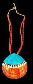
VINTAGE BEAUTIFUL SANTO DOMINGO STERLING SILVER INLAY TURQUOISE NECKLACEModern Jewelry4.5(182)See Sold PriceFeb 25, 2024
Vintage Santo Domingo Necklace Depression Era ThunderbirdCowboy Joe's Antiques4.7(189)See Sold PriceFeb 27, 2024
Julian Lovato Signed Santo Domingo Sterling and Turquoise RingCowboy Joe's Antiques4.7(189)See Sold PriceFeb 27, 2024
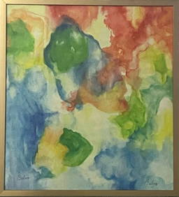
ALICE BABER - PORTO DE LA SILVA - PAINTING - ABSTRACT WATERCOLOR ON PAPER - IN THE STYLE OFThe Art's World4.3(1)See Sold PriceFeb 27, 2024
Santo Domingo Turquoise & Spiny Oyster Choker NecklaceBilly The Kid Auction House4.8(818)See Sold PriceMar 03, 2024
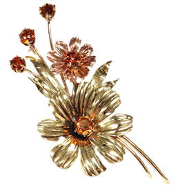
Tiffany & Co. Madeira Citrine 14k Rose Yellow Gold Floral Motif Numbered 1940s Retro Deco BroochHess Fine Auctions4.5(197)See Sold PriceMar 02, 2024
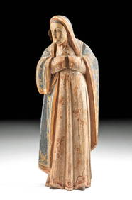
17th CENTURY ST. FRANCIS HAND PAINTED SANTOLewis & Maese Antiques & Auction4.4(520)See Sold PriceFeb 25, 2024
Santo Domingo Pottery Olla by Arthur & Hilda CorizZiebarth's Gallery4.4(81)See Sold PriceMar 01, 2024
Large Kewa (Santo Domingo) Pictorial Pottery Jars (Robert Tenorio)Ziebarth's Gallery4.4(81)See Sold PriceMar 01, 2024
Santo, scultura in argento, sec.XVIII h.cm.38Aste di Antiquariato Boetto4.3(47)See Sold PriceMar 06, 2024
1764 Bellin Map of Lesser Antilles Northern Portion -- Petites Antilles ou Isles du Vent 3e. Partie.Jasper524.5(9.8k)See Sold PriceFeb 27, 2024
19th C. Filipino Spanish Colonial Santo - Virgin MaryArtemis Fine Arts4.8(1.4k)See Sold PriceFeb 26, 2024
Santo Tomas de Villanueva Antique Oil on Wood PaintingAntiques Online Auctions4.6(407)See Sold PriceMar 14, 2024


![Madeira.- [Johnston (William)] [Geo-Hydrographic Survey (1 of 1)](https://p1.liveauctioneers.com/5458/147572/74578981_1_x.jpg?height=282&quality=70&version=1565275641)