ATLAS of ANTIENT GEOGRAPHY by SAMUEL BUTLER 1843John McInnis Auctioneers,LLC4.6(502)See Sold PriceFeb 24, 2024
18TH C. ANTIQUE MAP: FRENCH & INDIAN WAR, FRAMEDThomaston Place Auction Galleries4.4(386)See Sold PriceFeb 24, 2024
Rand McNally Railroad Map Cabinet w/ 21 Railroad MapsRail & Road Auctions4.6(165)See Sold PriceMar 08, 2024
Keith Haring - Ink on New York Map, Best Buddies, Inscribed, Signed, and DatedSapphire Auction Gallery4(67)See Sold PriceMar 02, 2024
LATE 17TH C. FRENCH MAP OF THE NEW WORLD BY ALEXIS-HUBERT JAILLOT (1632-1712)Thomaston Place Auction Galleries4.4(386)See Sold PriceFeb 24, 2024
Central Railroad of New Jersey Map of Sandy Hook Route-ca. 1903JM Hobby Supply and Railroad Artifact Auctions4.4(126)See Sold PriceFeb 24, 2024
Lot of Six Mixed Atlas Box Cars-HO Scale-New in BoxJM Hobby Supply and Railroad Artifact Auctions4.4(126)See Sold PriceFeb 25, 2024
Rand McNally/Santa Fe Railroad Map of Iowa-1912JM Hobby Supply and Railroad Artifact Auctions4.4(126)See Sold PriceFeb 24, 2024
NICOLAES VISSCHER (NETHERLANDS, 1618-1709) MAP OF THE NEW WORLDThomaston Place Auction Galleries4.4(386)See Sold PriceFeb 24, 2024
17TH C. WORLD MAP BY NICOLAES VISSCHER (NETHERLANDS, 1618-1709)Thomaston Place Auction Galleries4.4(386)See Sold PriceFeb 24, 2024
Lot of Six Mixed Atlas Cabooses-HO Scale-New in BoxJM Hobby Supply and Railroad Artifact Auctions4.4(126)See Sold PriceFeb 25, 2024
Cram: Antique Railraod Map of Texas, 1898Large and scarce 19th century railroad map of Texas in fine condition. Highly detailed railroad map from the extremely scarce 1898 Cram’s Bankers and Brokers Railroad Atlas published by GeorgeSee Sold Price
SoldTWO 19TH CENTURY MAPS OF ENGLAND, SCOTLAND, IRELANDIncludes an 1861 Johnson and Ward map of England and Wales, 25.5 x 17.25 inch sight size, matted. Also an unmatted map of Ireland and Scotland, also by Johnson and Ward, 1863, 18 x 26.25 inches.See Sold Price
SoldGroup of Five (5) 19th Century MapsIncluding England Scotland and Ireland Britain or the United Kingdom published by Cummings & Hillard No. 1 Cornhill Boston, Newfoundland Nova Scotia and New Brunswick map, French map of North America,See Sold Price
SoldGrp: Assorted Maps of EuropeLarge group of assorted 18th and 19th century maps of Europe. Includes two overall maps of Europe, one map of England and Wales, one map of Scotland, one map of France, one map of Greece, two maps ofSee Sold Price
19th century railroad map of Texas. George F. Cram,19th century railroad map of Texas. George F. Cram, 1898 Large and scarce 19 th century railroad map of Texas. George F. Cram, 1898. Highly detailed railroad map from the extremely scarce 1898 Cram’See Sold Price
Sold1850 McDowall Diamond Maps ATLAS Geography England1850 McDowall Diamond Maps ATLAS Geography England Scotland Ireland World Color A collection of 19th-century McDowall maps. These four maps are extremely desirable, hand-colored views. Maps include: �See Sold Price
Sold1886 1st ed Kidnapped Robert Louis Stevenson Scotland1886 1st ed Kidnapped Robert Louis Stevenson Scotland Jacobite Highlander MAP Robert Louis Stevenson was a 19th-century Scottish author known for his adventure novels such as ‘Dr. Jekyll and Mr. HydSee Sold Price
SoldScarce and huge RR map of California – 1898Toward the end of the 19th century, the better atlas makers had pushed the size and quality of their maps to the limit. George F. Cram was one of these publishers, but he also put out a special groupSee Sold Price
SoldLarge/scarce 1861 map of New York BayReserve Reduced! Large and scarce 1861 coastal map of New York City and its harbor. One of the earliest 19th century charts to depict New York City as we know it today. It shows Manhattan, Brooklyn anSee Sold Price
SoldOrdnance Survey maps,West Coast of Scotland, late 19th century with some revisions, approx 60 sheets, some with vignettes, including Lochs, Western Isles, Skye, Harris, Hebrides etc, condition varies (c.60)See Sold Price
SoldScarce 19th Century Tiffany Studios Gilt BronzePattern Postal Scale. With applied "jewels" and original celluloid front. Stamped Tiffany Studios and numbered 1627. From a Norwalk/Stamford estate. Dimensions: 1.75" wide x 3.25" deep x 3.25" high. CSee Sold Price
SoldCollection of 19th Century mapsVarious engravers and publishers including Augustus Mitchell A.J. Johnson New York, Taintor Bros & Merrill are a few. See photos for details. Fair to good condition as shown. Also a great 1832 by BaldSee Sold Price
SoldA SCARCE 19TH CENTURY OVAL BLOWN GLASS CLOCK DOMEThe tall glass dome on conforming wood base. Measures 21 x 16 x 10 inches. We happily provide seamless in-house packing and shipping services on nearly everything we sell.See Sold Price
SoldEarly 19th Century Map of LouisianaEarly 19th Century Map of Louisiana(Baltimore: F. Lucas, 1817), engraving with outline color, depicts adjacent areas in Mississippi, Alabama, Florida, Texas and Arkansas (being labeled "Missouri"). PrSee Sold Price
Sold19th century maps(lot of 4) 19th century maps of different sections of Paris, overall (framed/each): 21.5"h x 27.25"wSee Sold Price
SoldEarly 19th Century Map of Ontario and Yates County byEarly 19th Century Map of Ontario and Yates County by David H. Burr Sight 17 x 16 in. The estate of Dr. Seymour Ira Schwartz, Rochester, New York.See Sold Price
SoldScarce 19th century Naval sailors oil cloth soft hat.Scarce 19th century Naval sailors oil cloth soft hat. These were commonly used by many military sailors. 12" diameter x 4.25" high. Overall nice condition, has some ribbon fraying and tares in ribbon.See Sold Price
SoldEleven (11) 19th Century MapsIncluding Map of the State of Arkansasby TAINTOR BROS & MERRILL, Map of Wisconsin by Geo. F Cram, Johnson's NEW BRUNSWICK Nova Scotia, NEWFOUNDLAND and Prince Edward P. By Johnson and Ward Washington,See Sold Price
Sold(2) 19TH CENTURY MAPS OF MARYLAND, VIRGINIA, ETC.Includes: (1) "Map of Virginia and Maryland - Constructed from the Latest Authorities", dated 1825; published by A. Finley, Phila. 1824; engraved by J. H Young; Drawn by D H. Vance; exhibits the whiteSee Sold Price
SoldLarge Collection of 19th Century MapsVarious makers, engravers and publishers. See photos for details. Fair to good condition as shown. George CRAM, Johnsons Georgia and Alabama, Johnsons and Ward NEW YORK, J.H. Colton South Carolina andSee Sold Price
Sold(4) 19th Century Map Engravings.(4) 19th C. map engravings. A New and Accurate map of Europe. Drawn from the best Authorities, assisted by the most approved Charts and Maps and adjusted by Astronomical Observations by Eman Bowen;See Sold Price
Sold19th Century Map - A Plan of the Town, New HavenMap of plan of New Haven. Paper in linen. 19th century. Map opening size : H 7-3/4", W 6"; frame size: H 14", W 12". Excellent condition. Professionally framed. Collection of Laura Mitler. Please refeSee Sold Price
SoldTHREE 19TH CENTURY MAPS OF UTAHIncludes two 'by order of the honorable the Secretary of War,' and assisted by G.K. Gilbert, A.R. Marvine, E.E. Howell, and based on expeditions of 1872 and 1873. Both with sight sizes of approximatelSee Sold Price
SoldWall Maps. Two rolled 19th century maps mounted onWall Maps. Two rolled 19th century maps mounted on linen, for instructional use, one of the United States, and the other of Worcester County, some cracking and discoloration.See Sold Price
1853 FISHING Anglers Companion Scotland Rivers Lochs Salmon Trout Bait TackleSchilb Antiquarian Rare Books4.8(421)See Sold PriceMar 10, 2024
Scarce early American Masonic engraving. Late 18th/early 19th century. Engraved and published by F.Tremont Auctions4.6(293)See Sold PriceFeb 25, 2024
1849 Mitchell School ATLAS 24 MAPS America Holy Land France Africa Egypt AsiaSchilb Antiquarian Rare Books4.8(421)See Sold PriceMar 31, 2024
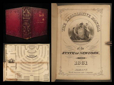
1861 Civil War Legislative Manual New York 84th Congress US Captain PROVENANCESchilb Antiquarian Rare Books4.8(421)See Sold PriceMar 31, 2024
1872 Holy BIBLE & Hitchcock Analysis Gruden Concordance Theology MAPS Holy LandSchilb Antiquarian Rare Books4.8(421)See Sold PriceMar 31, 2024
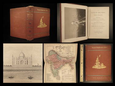
1872 INDIA Land of the Veda Travel Exploration Voyages Hindu Sepoy RebellionSchilb Antiquarian Rare Books4.8(421)See Sold PriceMar 31, 2024
A 19TH CENTURY HAND COLOURED MAP OF ORKNEY AND SHETLANDHutchinson Scott Auctioneers4.4(39)See Sold PriceFeb 28, 2024
AMBER BLOWN GLASS WRYTHEN BOTTLE.Amelia Jeffers, Auctioneers & Appraisers4.6(101)See Sold PriceMar 08, 2024
THREE HAND COLORED AND ADORNED PRINTS.Amelia Jeffers, Auctioneers & Appraisers4.6(101)See Sold PriceMar 08, 2024
1825 Vandermaelen Map of the Curacao, Aruba -- Amer. Sep. Curacao No. 74.Jasper524.5(9.8k)See Sold PriceFeb 27, 2024
COLONIES FRANÇAISES en AFRIQUE. Africa Sénégal Madagascar. LEVASSEUR c1850 mapJasper524.5(9.8k)See Sold PriceFeb 28, 2024
Johnson's Africa. Colonies & tribes. Liberia Nile Delta Cape Colony 1866 mapJasper524.5(9.8k)See Sold PriceFeb 28, 2024
West Africa. Sahara caravan routes. Tribes Kingdoms Empires. LIZARS 1842 mapJasper524.5(9.8k)See Sold PriceFeb 28, 2024
Afrique Ancienne. Ancient North Africa. MALTE-BRUN c1871 old antique map chartJasper524.5(9.8k)See Sold PriceFeb 28, 2024
Two Hand-Colored 19th Century Maps of New Orleans and Louisiana, Larger- H.- 12 1/2 in., W.- 15 1/2Crescent City Auction Gallery4.3(229)See Sold PriceMar 08, 2024
Rare 19thc Colton Map, Argentine Republic, Chile, Uruguay, PataguayConnoisseur Auctions4(333)See Sold PriceMar 16, 2024