ATLAS of ANTIENT GEOGRAPHY by SAMUEL BUTLER 1843John McInnis Auctioneers,LLC4.6(502)See Sold PriceFeb 24, 2024
18TH C. ANTIQUE MAP: FRENCH & INDIAN WAR, FRAMEDThomaston Place Auction Galleries4.4(386)See Sold PriceFeb 24, 2024
Rand McNally Railroad Map Cabinet w/ 21 Railroad MapsRail & Road Auctions4.6(165)See Sold PriceMar 08, 2024
Keith Haring - Ink on New York Map, Best Buddies, Inscribed, Signed, and DatedSapphire Auction Gallery4(67)See Sold PriceMar 02, 2024
LATE 17TH C. FRENCH MAP OF THE NEW WORLD BY ALEXIS-HUBERT JAILLOT (1632-1712)Thomaston Place Auction Galleries4.4(386)See Sold PriceFeb 24, 2024
Central Railroad of New Jersey Map of Sandy Hook Route-ca. 1903JM Hobby Supply and Railroad Artifact Auctions4.4(126)See Sold PriceFeb 24, 2024
Lot of Six Mixed Atlas Box Cars-HO Scale-New in BoxJM Hobby Supply and Railroad Artifact Auctions4.4(126)See Sold PriceFeb 25, 2024
Rand McNally/Santa Fe Railroad Map of Iowa-1912JM Hobby Supply and Railroad Artifact Auctions4.4(126)See Sold PriceFeb 24, 2024
NICOLAES VISSCHER (NETHERLANDS, 1618-1709) MAP OF THE NEW WORLDThomaston Place Auction Galleries4.4(386)See Sold PriceFeb 24, 2024
17TH C. WORLD MAP BY NICOLAES VISSCHER (NETHERLANDS, 1618-1709)Thomaston Place Auction Galleries4.4(386)See Sold PriceFeb 24, 2024
Lot of Six Mixed Atlas Cabooses-HO Scale-New in BoxJM Hobby Supply and Railroad Artifact Auctions4.4(126)See Sold PriceFeb 25, 2024
Sold1851 Tallis Map of British India -- British IndiaTitle/Content of Map: 1851 Tallis Map of British India -- British India Date: 1851, London Cartographer: J TallisSize: 12.9 x 9.5 in. This is a very nice map of India under British rule from Punjab toSee Sold Price
1851 Tallis Map of British India -- British IndiaReserve Reduced! Title/Content of Map: 1851 Tallis Map of British India -- British India Date: 1851, London Cartographer: J Tallis Size: 12.9 x 9.5 in. This is a very nice map of India under British rSee Sold Price
1851 Tallis Map of British India -- British IndiaTitle/Content of Map: 1851 Tallis Map of British India -- British India Date: 1851, London Cartographer: J Tallis Size: 12.9 x 9.5 in. This is a very nice map of India under British rule from Punjab tSee Sold Price
1851 Tallis Map of British India -- British IndiaTitle/Content of Map: 1851 Tallis Map of British India -- British India Date: 1851, London Cartographer: J Tallis Size: 12.9 x 9.5 in. This is a very nice map of India under British rule from Punjab tSee Sold Price
1851 Tallis Map of British India -- British IndiaTitle/Content of Map: 1851 Tallis Map of British India -- British India Date: 1851, London Cartographer: J Tallis Size: 12.9 x 9.5 in. This is a very nice map of India under British rule from Punjab tSee Sold Price
1851 Tallis Map of British India -- British IndiaTitle/Content of Map: 1851 Tallis Map of British India -- British India Date: 1851, London Cartographer: J Tallis Size: 12.9 x 9.5 in. This is a very nice map of India under British rule from Punjab tSee Sold Price
Sold1851 Tallis Map of British India -- British IndiaTitle/Content of Map: 1851 Tallis Map of British India -- British India Date: 1851, London Cartographer: J Tallis Size: 12.9 x 9.5 in. This is a very nice map of India under British rule from Punjab tSee Sold Price
Sold1851 British India & Denmark MapsUnframed c. 1851 John Tallis & Company published steel lined engraved maps of British India & Denmark, both are engraved by J. Rapkin, British India is illustrated by A. H. Wray engraved by G. GreatbaSee Sold Price
Tallis / Rapkin: Antique Map of British India, 1858Title/Content of Map: 'British India' Railways. Military bases. Mutiny events. Date Printed: 1858 Image Size: Approx 33.5 x 25.5cm, 13.25 x 10 inches (Large) Type: Antique steel engraved map with origSee Sold Price
Sold2 maps of India by TallisTitle: Two maps, Northern India [and] British India Author: Tallis, John Description: Includes: * British India. Map drawn & engraved by J. Rapkin. Illustrations by A.H. Wray, engraved by G. GreatbachSee Sold Price
SoldIndia.- Tallis (John) British India; Overland Route toIndia.- Tallis (John) British India; Overland Route to India, two decorative maps of India, both embellished with engraved vignettes, from Tallis's 'The Illustrated Atlas and Modern History of the WorSee Sold Price
SoldTallis/Rapkin: Antique Map of British India, 1858Title/Content of Map: 'British India' Railways. Military bases. Mutiny events. Date Printed: 1858 Image Size: Approx 33.5 x 25.5cm, 13.25 x 10 inches (Large) Type: Antique steel engraved map with origSee Sold Price
"British India, southern part". Malabar & CoromandelTITLE/CONTENT OF MAP: 'British India, southern part' A large detailed map of southern India showing British territories and Native States. The Malabar, Coromandel and Pirate coasts are marked. Part ofSee Sold Price
Thomson: Antique Map of Southern British India 1817TITLE/CONTENT OF MAP: 'British India, southern part' A large detailed map of southern India showing British territories and Native States. The Malabar, Coromandel and Pirate coasts are marked. Part ofSee Sold Price
SoldBritish India 1897Title/Content of Map: British India 1897 Date Printed: 1897 Material/Medium: paper Size: approx. 11x 14 inches Additional Info: Cram's Universal Atlas Geographical, Astronomical and Historical Atlas RSee Sold Price
Thomson: Antique Map of British India, 1817TITLE/CONTENT OF MAP: 'British India, southern part' A large detailed map of southern India showing British territories and Native States. The Malabar, Coromandel and Pirate coasts are marked. Part ofSee Sold Price
Sold"British India, northern part" w/ Nepal & Cabul.TITLE/CONTENT OF MAP: 'British India, northern part // Nepaul // Cabul' A detailed map of Northern British India, Nepal, and the environs of Kabul. The supposed course of the "Gaggar" (Ghaggar or LuniSee Sold Price
SoldThomson: Antique Map of British India, 1814Map: British India Southern Part/British India Northern Part Cartographer: Thomson Place & Date: Edinburgh / 1814/1817 Size: 24 1/8" x 22 5/8" Condition: overall age-toning and spotting; repaired spliSee Sold Price
Tallis/Rapkin: Antique Map of British India, 1858Title/Content of Map: 'British India' Railways. Military bases. Mutiny events. Date Printed: 1858 Image Size: Approx 33.5 x 25.5cm, 13.25 x 10 inches (Large) Type: Antique steel engraved map with origSee Sold Price
BRITISH INDIA showing military bases & proposedTITLE/CONTENT OF MAP: 'British India' The key indicates the Presidencies of India, military and civil stations, and proposed railways (black) connecting Delhi, Bombay and Calcutta. At the time of publSee Sold Price
British India 1897Title/Content of Map: British India 1897 Date Printed: 1897 Material/Medium: paper Size: approx. 11x 14 inches Cram's Universal Atlas Geographical, Astronomical and Historical Atlas Reserve: $20.00 ShSee Sold Price
BRITISH INDIA. shows 'Proposed Railways'. MilitaryTITLE/CONTENT OF MAP: 'British India' The key indicates the Presidencies of India, military and civil stations, and proposed railways (black) connecting Delhi, Bombay and Calcutta. At the time of publSee Sold Price
BRITISH INDIA. Railways. Military bases. Mutiny events.TITLE/CONTENT OF MAP: 'British India' The top image on the right hand side shows the entire map. To view a close up of the map showing the level of printed detail, please click on the bottom image onSee Sold Price
BRITISH INDIA. Railways. Military bases. Mutiny events.TITLE/CONTENT OF MAP: 'British India' DATE: 1858 IMAGE SIZE: Approx 33.5 x 25.5cm, 13.25 x 10 inches (Large) TYPE: Antique steel engraved map with original outline hand colouring CONDITION: Fair: SpliSee Sold Price
John Horace Hooper (British 1851 - 1906) Oil Painting Landscape w/ FishermanGlobal Auctions Company4.3(36)See Sold PriceMar 03, 2024
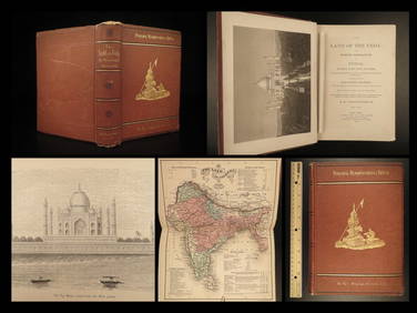
1872 INDIA Land of the Veda Travel Exploration Voyages Hindu Sepoy RebellionSchilb Antiquarian Rare Books4.8(421)See Sold PriceMar 31, 2024
1935 British India RPPC Postcard Cover to Purora CzechoslovakiaMynt Auctions4.6(680)See Sold PriceFeb 25, 2024
1932 Ireland Airmail First Flight Cover FFC Dublin to Bellary British IndiaMynt Auctions4.6(680)See Sold PriceFeb 26, 2024
1945 British Burma Cover Bassein to Devakottai Madras IndiaMynt Auctions4.6(680)See Sold PriceFeb 26, 2024
AN ANTIQUE FOLDING MAP OF THE BRITISH ISLES DATED 1873Hutchinson Scott Auctioneers4.4(39)See Sold PriceFeb 28, 2024
D'Oyly (Calcutta, India) - Government House from St. Andrew's LibraryTrillium Antique Prints & Rare Books4.5(30)See Sold PriceFeb 24, 2024
D'Oyly (Calcutta, India) - Procession of the CurruckpoojaTrillium Antique Prints & Rare Books4.5(30)See Sold PriceFeb 24, 2024
William Mellor (1851-1931), British School, Oil on canvas, A woodland landscape scene with figuresClaydon Auctioneers Ltd4.3(125)See Sold PriceFeb 26, 2024
GOVIND SOLEGAONKAR (Sehore, Madhya Pradesh, British India, 1912-1986). "Abstract composition."Setdart Auction House4.1(22)See Sold PriceMar 05, 2024
INDIA WITHIN THE GANGES SUSAN GOLE ILLUSTRATED MAPS EARLY CARTOGRAPHYJasper524.5(9.8k)See Sold PriceFeb 27, 2024
British India/China 2-Coin Set the First War on DrugsGolden Air Auctions4.4(257)See Sold PriceFeb 25, 2024
1906 India-British 1 Rupee KM# 508 ASW: 0.3438oz XF/AUAndrew's Coin & Jewelry4.5(209)See Sold PriceMar 07, 2024