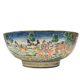
Important Qianlong Chinese Export Hunt Scene BowlPremier Auction Galleries4.3(329)See Sold PriceMar 09, 2024
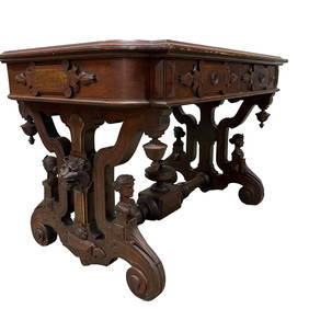
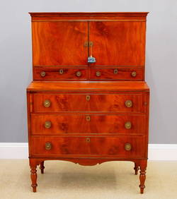
American Renaissance Revival Carved Partners DeskPremier Auction Galleries4.3(329)See Sold PriceMar 09, 2024
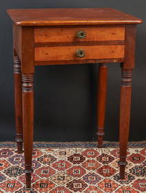
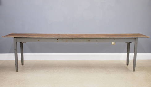
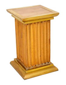
(19th c) CHERRY, MAHOGANY & MAPLE (2) DRAWER STANDJohn McInnis Auctioneers,LLC4.6(504)See Sold PriceFeb 24, 2024
Louis XV Style Marquetry Inlaid Writing DeskNadeau's Auction Gallery4.7(405)See Sold PriceFeb 24, 2024
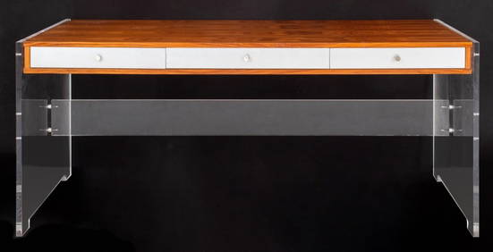
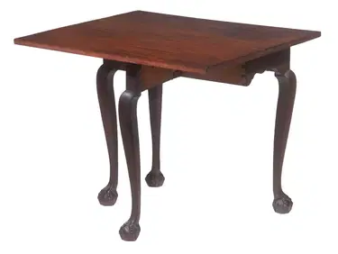
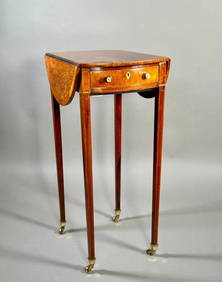
RARE DIMINUTIVE CHIPPENDALE SINGLE DROP-LEAF TABLEThomaston Place Auction Galleries4.4(389)See Sold PriceFeb 24, 2024
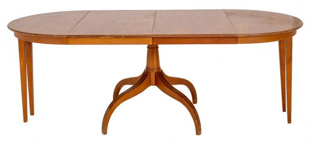
A Fine and Rare Small George III Rosewood and Satinwood Pembroke TableNeue Auctions4.6(356)See Sold PriceMar 02, 2024
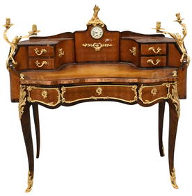
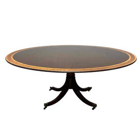
20th C. Five Foot Round Banded Mahogany Pedestal TablePremier Auction Galleries4.3(329)See Sold PriceMar 09, 2024
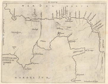
Munster Americas MapMunster, Sebastian (1488-1552). Le table des neufues lefquells on appelle isle d'occifent & d'Indie pour divers regard. Woodcut map. Basel, 1540 (State 12, 1569). 11 1/2" x 15 1/4" sheet, 23" x 26 1/2See Sold Price
SoldMunster map of Americas 1574Heading: (Maps) Author: Münster, Sebastian Title: Die neüwen Inseln/ so hinder Hispanien gegen Orient bey dem land Indie ligen Place Published: Basel, Switzerland Publisher: Date Published:See Sold Price
SoldMunster map of Americas 1574Heading: (Americas) Author: Münster, Sebastian Title: Die neüwen Inseln/ so hinder Hispanien gegen Orient bey dem land Indie ligen Place Published: Basel, Switzerland Publisher: Date Published: <See Sold Price
SoldMunster Map of AmericasTabula novarum insularum, quas Diversis respectibus Occidentales & Indianas uocant. Sebastian Munster (1488-1552). Woodcut map. Basel, Henri Petri, 1559. 11 1/4 x 14 3/4 inches visible, 19 1.4 x 22 3/See Sold Price
SoldMunster Woodcut Map of AmericasTabula novarum insularum...Sebastian Munster (1488-1552). Woodcut map with hand color in full. Basel, 1550 (state 5, Latin text). 11 1/2 x 14 3/4 inches visible, 20 1/2 x 22 inches framed. One of theSee Sold Price
SoldMunster Woodcut Map of the AmericasTauola dell'isole nuoue, le quali son nominate occidentali,...Sebastian Munster (1489-1552). Woodcut map. Basel, 1588. (State 8). 11 x 14 inches visible, 20 x 22 1/2 inches framed.See Sold Price
SoldMunster (Sebastian) - Americae Novi Orbis, NovaMunster second map of the Americas, based on that of Ortelius, woodcut map, 315 x 360mm., German text verso, central vertical fold, [Basel], [1598].See Sold Price
SoldMunster, First Map Map of the Americas, 1554Tabula novarum insularum, quas Diversis respectibus Occidentales & Indianas uocant. Sebastian Munster (1488-1552). Basel, 1554. Engraved Map. 11 1/2 x 14 1/2 inches visible, 19 x 23 inches framed. TheSee Sold Price
SoldMunster map of America 1614Heading: (Americas) Author: Münster, Sebastian Title: Americæ sive Novi Orbis, Nova Descriptio Place Published: Basel Publisher:Sebastian Petri Date Published: 1588-[1614] Description:See Sold Price
SoldMünster map of Americas 1545Heading: Author: Münster, Sebastian Title: Die neüwen Inselen / so zu unsern zeicen durch die kunig von Hispania im grossen Oeano gefunden sinde Place Published: Basel, Switzerland Publisher: DaSee Sold Price
SoldMuenster's map of the Americas, 1574Title: Die neüwen Inseln/ so hinder Hispanien gegen Orient bey dem land Indie ligen Author: Münster, Sebastian Description: Woodcut map, hand-colored (later). 25.2x33.8 cm. (10x13¼").One of the mosSee Sold Price
Soldc.1600 Swiss Map of the Americas.Attributed to Sebastian Munster via 2005 Auction Catalogue with the title: Americæ sive Novi Orbis, Nova. Published in Basel by Sebastian Petri. Woodcut map, modern hand-coloring plus German title atSee Sold Price
SEBASTIAN MUNSTER (German 1488-1552)Map of the Americas Hand colored woodcut map (framed) 11 5/8" x 14 3/4" (sight) Provenance: Property from the Estate of Florence Knoll BassettSee Sold Price
SoldMuenster's map of the Americas, 1564Title: Die neüwen Inseln/ so hinder Hispanien gegen Orient bey dem land Indie ligen Author: Münster, Sebastian Description: Woodcut map. 25.2x33.8 cm. (10x13¼"). One of the most influential early mSee Sold Price
Sold[Munster (S)] Americæ Sive Novi Orbis,[Munster (Sebastian)] Americæ Sive Novi Orbis, Nova Descriptio,the Americas, with large title cartouche and gothic text above, woodcut map, 310 x 365mm., headpiece and German text on verso, ceSee Sold Price
Sold1572 Munster map of Islands, Sea Monsters, ShipsNo Reserve! Nice map of various islands from Munster’s “Cosmographia,” one of the most important early atlases. This woodcut is typical in that Munster used the same woodcut to illustrate the WeSee Sold Price
SoldSEBASTIAN MUNSTER, MAP OF THE WORLD, FRAMEDSebastian Munster (German, 1488-1552). "Map of the Ptolemaic World" from "Cosmographia", engraving with hand coloring, framed. Approx. 18.5" x 20.25" (frame), 12.75" x 14.5" (sight) Item from the EstaSee Sold Price
SoldMunster map of New World 1550Heading: Author: Münster, Sebastian Title: Tabula nouarum insularum, quas diuersis respectibus Occidentales & Indianas uocant Place Published: Basel, Switzerland Publisher: Date Published: 1See Sold Price
SoldSebastian Munster Map of Paris 1550Sebastian Munster (1488-1552), "La ville de Paris, par tout tant renommee, & principalle ville du royaulme de France," ca. 1568. This hand-colored woodcut map of Paris shows the city from a birdseye vSee Sold Price
SoldMunster: Map of Inca Capital of Cusco, 1550Map: Die Statt Cusco Cartographer: Sebastian Munster Place & Date: Basle / 1550 Size: 14 3/4" x 10 5/8" The magnificent view of the ancient Inca capital of Cusco from Münster's influential CosmographSee Sold Price
Sebastian Munster: Map of Poland & Hungary. 1542, BaselPolonia Et Ungaria XV Nova Tabula. One of the earliest maps of Poland, with Lithuania to the North, south of the Danube, east to the Black Sea with river Dnieper basin and Bessarabia. CARTOGRAPHER SebSee Sold Price
SoldAntique Sebastian Munster Map of Ancient RomeAntique Sebastian Munster Map of Ancient Rome. Profeisonally matted and framed. Frame measures 21 inches x 26 inches.See Sold Price
SoldMunster map of Great Britain 1588Heading: (Great Britain) Author: Münster, Sebastian Title: Das Under Buch Beschreibung Engellandts und Schottlandts Place Published: Basel Publisher: Date Published: 1588 Description: <See Sold Price
Chatelain - Map of the Americas and Details and Insets of Government CounselsTrillium Antique Prints & Rare Books4.5(30)See Sold PriceFeb 24, 2024
Chatelain - 3 Maps of the British Isles (England, Ireland, Scotland)Trillium Antique Prints & Rare Books4.5(30)See Sold PriceFeb 24, 2024
NASA Facts JFK Space Center Booklet And MoreRapid Estate Liquidators and Auction Gallery4.5(1.1k)See Sold PriceFeb 24, 2024


![[Munster (S)] Americæ Sive Novi Orbis, (1 of 0)](https://p1.liveauctioneers.com/dist/images/placeholder.jpg?height=282&quality=70)