ATLAS of ANTIENT GEOGRAPHY by SAMUEL BUTLER 1843John McInnis Auctioneers,LLC4.5(505)See Sold PriceFeb 24, 2024
18TH C. ANTIQUE MAP: FRENCH & INDIAN WAR, FRAMEDThomaston Place Auction Galleries4.4(393)See Sold PriceFeb 24, 2024
Rand McNally Railroad Map Cabinet w/ 21 Railroad MapsRail & Road Auctions4.6(165)See Sold PriceMar 08, 2024
Keith Haring - Ink on New York Map, Best Buddies, Inscribed, Signed, and DatedSapphire Auction Gallery4.1(67)See Sold PriceMar 02, 2024
LATE 17TH C. FRENCH MAP OF THE NEW WORLD BY ALEXIS-HUBERT JAILLOT (1632-1712)Thomaston Place Auction Galleries4.4(393)See Sold PriceFeb 24, 2024
Central Railroad of New Jersey Map of Sandy Hook Route-ca. 1903JM Hobby Supply and Railroad Artifact Auctions4.4(127)See Sold PriceFeb 24, 2024
Lot of Six Mixed Atlas Box Cars-HO Scale-New in BoxJM Hobby Supply and Railroad Artifact Auctions4.4(127)See Sold PriceFeb 25, 2024
Rand McNally/Santa Fe Railroad Map of Iowa-1912JM Hobby Supply and Railroad Artifact Auctions4.4(127)See Sold PriceFeb 24, 2024
NICOLAES VISSCHER (NETHERLANDS, 1618-1709) MAP OF THE NEW WORLDThomaston Place Auction Galleries4.4(393)See Sold PriceFeb 24, 2024
17TH C. WORLD MAP BY NICOLAES VISSCHER (NETHERLANDS, 1618-1709)Thomaston Place Auction Galleries4.4(393)See Sold PriceFeb 24, 2024
Lot of Six Mixed Atlas Cabooses-HO Scale-New in BoxJM Hobby Supply and Railroad Artifact Auctions4.4(127)See Sold PriceFeb 25, 2024
New Map of the Upper Part of Italy Containing...Title: New Map of the Upper Part of Italy Containing... Publication Date: c1721 Publisher: THOS. BOWLES... AND JOHN BOWLES... Size: 24 x 40 "...ye Principality Piermont ye Dutchies of Savoy, Milan, PaSee Sold Price
New Map of the Upper Part of Italy Containing...Reserve Reduced! Title: New Map of the Upper Part of Italy Containing... Publication Date: c1721 Cartographer: MOLL, HERMAN Publisher: THOS. BOWLES... AND JOHN BOWLES... Size (inches): 24 x 40 "...yeSee Sold Price
New Map of the Upper Part of Italy Containing...Title: New Map of the Upper Part of Italy Containing... Publication Date:1721 ca. Cartographer: MOLL, HERMAN Publisher: THOS. BOWLES... AND JOHN BOWLES... Brief Description: "...ye Principality PiermoSee Sold Price
New Map of the Upper Part of Italy Containing...Title/Content of Map: New Map of the Upper Part of Italy Containing... Cartographer: MOLL, HERMAN Date: c1721 Publisher: THOS. BOWLES... AND JOHN BOWLES... Size: 24Height - 40Width "...ye PrincipalitySee Sold Price
New Map of the Upper Part of Italy Containing...Title/Content of Map: New Map of the Upper Part of Italy Containing... Cartographer: MOLL, HERMAN Date: c1721 Publisher: THOS. BOWLES... AND JOHN BOWLES... Size: 24Height - 40Width "...ye PrincipalitySee Sold Price
SoldLarge George II Map of Northern Italy by MollMoll, Herman (1654-1732). New Map of the Upper Part of Italy Containing... Engraved map. Thomas Bowles & John Bowles, c.1721. 24" x 40" sheet. "...ye Principality Piermont ye Dutchies of Savoy, Milan,See Sold Price
Sold1 piece. Hand-Colored Engraved Map. Laurie, Rober1 piece. Hand-Colored Engraved Map. Laurie, Robert; Whittle, James. A New Map of The Middle & Upper Parts of Italy,... Tuscany;... Lombardy,... Parma,... Venice..." London, 1799. 27 1/4 x 19 3/4 incheSee Sold Price
SoldMap of the Battle of Harlem HeightsHeading: (New York) Author: Shannon, Joseph Title: Map of the Upper Part of the Island of Manhattan Above Eighty-Sixth Street Arranged to Illustrate the Battle of Harlem Heights Place Published: [NewSee Sold Price
Map of the Battle of Harlem HeightsHeading: (New York) Author: Shannon, Joseph Title: Map of the Upper Part of the Island of Manhattan Above Eighty-Sixth Street Arranged to Illustrate the Battle of Harlem Heights Place Published: [NewSee Sold Price
Sold1747 Bowen Map of Southern Portion of Africa -- A New &Title/ Content of Map: 1747 Bowen Map of Southern Portion of Africa -- A New & Accurate Map of the Southern Parts of Africa Containing Lower Guinea, Monoemugi, Zanguebar, the Empire of Monomotapa, CouSee Sold Price
Northern Italy & Leghorn 1747Heading: Author: Bowen, Emanuel Title: A New and Accurate Map of the Northern Parts of Italy... [on sheet with] A Draught of the Road of Leghorn Place Published: London Publisher: Date PublishedSee Sold Price
SoldBowen map of southern Africa 1747Heading: Author: Bowen, Emanuel Title: A New & Accurate Map of the Southern Parts of Africa, Containing Lower Guinea, Monoemugi, Zanguebar, the Empire of Monomatapa, Country of the Cafres &c. and theSee Sold Price
Bowen map of southern Africa 1747Heading: Author: Bowen, Emanuel Title: A New & Accurate Map of the Southern Parts of Africa, Containing Lower Guinea, Monoemugi, Zanguebar, the Empire of Monomatapa, Country of the Cafres &c. and theSee Sold Price
SoldPair of American MapsA New Map of the United States by Cary, 1806, 18" x 20" together with The Upper Part of Manhattan by Rogers, 1868, 14" x 23" Pair of American MapsSee Sold Price
Cary: Antique Map of New England, 1811An original hand colored engraved 1811 map titled ""A New Map of Part of the United States of North America Containing New York, Vermont, New Hampshire, Massachusets, Connecticut, Rhode Island, PennsySee Sold Price
SoldCary Map of Florida, Georgia, North Carolina, SouthCary, John (British, 1754-1835). A New Map of Part of the United States of North America, Containing the Carolinas and Georgia, also the Floridas and Part of the Bahama Islands. London: 1806. EngravedSee Sold Price
SoldCary's Map of the Southern United States, 1806A New Map of Part of the United States of North America Containing the Carolinas and Georgia, Also the Floridas and Part of the Bahama Islands, etc. by John Cary, 1806, a partially hand-coSee Sold Price
SoldJohn Cary (British, 1754-1835)John Cary (British, 1754-1835), "A New Map of Part of The United States of North America Containing the Carolinas and Georgia, also The Floridas and Part of The Bahama Islands & C.", London, 1806, hanSee Sold Price
19th century map of the southeast,A New Map of Part of the United States of North America, containing the Carolinas and Georgia. Also the Floridas and part of the Bahama islands, &c., by John Cary, published in [Cary's New Universal ASee Sold Price
Sold1 piece. Hand-Colored Engraved Map. Cary, John. A1 piece. Hand-Colored Engraved Map. Cary, John. A New Map of Part of The United States of North America Containing the Carolinas and Georgia, also The Floridas and Part of The Bahama Islands & C." LonSee Sold Price
SoldJohn Cary U.S. map,"A New Map of Part of the United States of North America, containing the Carolinas and Georgia also the Floridas…", published by John Cary, London, 1819, copper plate engraving, hand colored, centerSee Sold Price
SoldCary Map of the Southeast, 1821, inc. AlabamaJohn Cary: A NEW MAP OF PART OF THE UNITED STATES OF NORTH AMERICA, CONTAINING THE CAROLINAS and GEORGIA, ALSO THE FLORIDAS AND PART OF THE BAHAMA ISLANDS & C., 1821. Scarce map, the only edition of CSee Sold Price
SoldA map of Georgia the Carolinas Floridas and Bahamas by John Cary 1806John Cary, a large, early 19th century engraved, colored map titled "A New Map of Part of the United States of North America Containing the Carolinas and Georgia, Also the Floridas and part of the BahSee Sold Price
SoldJacques Nicolas BELLIN - An essay of a new and compactJacques Nicolas BELLIN - An essay of a new and compact map containing the known parts of the terrestrial globe = Essay d'une carte reduite contenant les parties connues du globe terrestre = Proef vanSee Sold Price
MATTHEWS c1856 Map Of Upper Canada Ontario Indian Land Agency Divisions Scarce!Luis Porretta Fine Arts4.3(10)See Sold PriceMar 02, 2024
1849 THE NEW-ENGLAND MERCANTILE UNIONNorth American Artifact Auctions4.7(198)See Sold PriceApr 20, 2024
[ARCTIC]. BOWEN, Emanuel. A New & Accurate Map of the North...Potter & Potter Auctions4.6(545)See Sold PriceMar 07, 2024
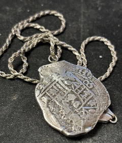
1715 Fleet Shipwreck 8 Reale Silver Piece of 8 coin PendantJC Auctions4.4(47)See Sold PriceFeb 27, 2024
Mitchell - Map of the City of Washington (Washington, DC)Trillium Antique Prints & Rare Books4.5(32)See Sold PriceFeb 24, 2024
1816 MAP SOUTHERN PART OF RUSSIA or MUSCOVY in EUROPE copper engraving ANTIQUEJasper524.5(9.9k)See Sold PriceFeb 27, 2024
1816 MAP NORTHERN PART OF RUSSIA or MUSCOVY in EUROPE copper engraving ANTIQUEJasper524.5(9.9k)See Sold PriceFeb 27, 2024
BEAUTIFUL LAMP BY THE SIGNATURE F. VALENTI- SPAIN 1960s - BRONZEABC Gallery4.2(8)See Sold PriceMar 18, 2024
Carte de la Guinée, contenant…'. Guinea & Cape Verde islands. BONNE 1771 mapJasper524.5(9.9k)See Sold PriceFeb 28, 2024
Black and white map of part of New York City (mostly Manhattan)Proverde Auctions4.3(3)See Sold PriceFeb 28, 2024
Laminated Unique Media New York City MapRapid Estate Liquidators and Auction Gallery4.5(1.1k)See Sold PriceFeb 29, 2024
Herman Moll A New Map of Ye North Parts of AmericaWillow Auction House4.5(289)See Sold PriceMar 14, 2024
Italian Mid Century Fontana Arte Style Brass Finish Metal and Glass Eight-Light Chandelier In theDOYLE Auctioneers & Appraisers4.6(171)See Sold PriceMar 06, 2024
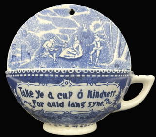
VINTAGE BLUE WHITE TRANSFERWARE HALF CUP KINDNESS AULD LANG SYNE WALL POCKETJasper524.5(9.9k)See Sold PriceMar 07, 2024


![[ARCTIC]. BOWEN, Emanuel. A New & Accurate Map of the North... (1 of 1)](https://p1.liveauctioneers.com/928/318880/171360917_1_x.jpg?height=282&quality=70&version=1707501302)