ATLAS of ANTIENT GEOGRAPHY by SAMUEL BUTLER 1843John McInnis Auctioneers,LLC4.6(502)See Sold PriceFeb 24, 2024
18TH C. ANTIQUE MAP: FRENCH & INDIAN WAR, FRAMEDThomaston Place Auction Galleries4.4(386)See Sold PriceFeb 24, 2024
Rand McNally Railroad Map Cabinet w/ 21 Railroad MapsRail & Road Auctions4.6(165)See Sold PriceMar 08, 2024
Keith Haring - Ink on New York Map, Best Buddies, Inscribed, Signed, and DatedSapphire Auction Gallery4(67)See Sold PriceMar 02, 2024
LATE 17TH C. FRENCH MAP OF THE NEW WORLD BY ALEXIS-HUBERT JAILLOT (1632-1712)Thomaston Place Auction Galleries4.4(386)See Sold PriceFeb 24, 2024
Central Railroad of New Jersey Map of Sandy Hook Route-ca. 1903JM Hobby Supply and Railroad Artifact Auctions4.4(126)See Sold PriceFeb 24, 2024
Lot of Six Mixed Atlas Box Cars-HO Scale-New in BoxJM Hobby Supply and Railroad Artifact Auctions4.4(126)See Sold PriceFeb 25, 2024
Rand McNally/Santa Fe Railroad Map of Iowa-1912JM Hobby Supply and Railroad Artifact Auctions4.4(126)See Sold PriceFeb 24, 2024
NICOLAES VISSCHER (NETHERLANDS, 1618-1709) MAP OF THE NEW WORLDThomaston Place Auction Galleries4.4(386)See Sold PriceFeb 24, 2024
17TH C. WORLD MAP BY NICOLAES VISSCHER (NETHERLANDS, 1618-1709)Thomaston Place Auction Galleries4.4(386)See Sold PriceFeb 24, 2024
Lot of Six Mixed Atlas Cabooses-HO Scale-New in BoxJM Hobby Supply and Railroad Artifact Auctions4.4(126)See Sold PriceFeb 25, 2024
SoldMAP - Crete. Ortelius/GalleCrete. Ortelius/Galle, Candia olim Creta, 1590 (published). Hand Color. Beautifully and fully engraved copper plate map features exceptional detail of the island. The map has numerous place names andSee Sold Price
Ortelius / Galle: Map of Crete, 1580Map: Candia olim Creta Cartographer: Ortelius / Galle Place & Date: Antwerp / 1580s Size: 4 3/4" x 3 3/8" Condition: b&w; overall age toning; some staining along outer margins; a strong, dark impressiSee Sold Price
Ortelius / Galle: Antique Map of Crete, 1580Map: Candia olim Creta Cartographer: Ortelius / Galle Place & Date: Antwerp / 1580s Size: 4 3/4" x 3 3/8" Condition: b&w; overall age toning; some staining along outer margins; a strong, dark impressiSee Sold Price
SoldOrtelius/Galle: Crete 1580sMap: Candia olim Creta Cartographer: Ortelius / Galle Place & Date: Antwerp / 1580s Size: 4 3/4" x 3 3/8" Condition: b&w; overall age toning; some staining along outer margins; a strong, dark impressiSee Sold Price
Sold(MAP, CRETE) DE WIT, FREDERICK. Insula candia. Amst(MAP, CRETE) DE WIT, FREDERICK Insula Candia. Amsterdam, circa 1680. Hand-colored engraved map of Crete. The emphasis on fortifications reflects contemporary events in the capital of Candia. An importSee Sold Price
MAP, Crete, HomannCrete. Johann Baptist Homann, Insula Creta Hodie Candia in sua IV. Territoria Divisa cum Adjacentibus Aegei Maris Insulis..., 1716 (published). Hand Color. This is a handsome, decorative map of CreteSee Sold Price
MAP, Crete, WitCrete. Frederick de Wit, Insula Candia Ejusque Fortificatio, 1688 (circa). Hand Color. This dramatic map of Crete shows the island following the Siege of Candia, a conflict in which Ottoman forces besSee Sold Price
SoldMAP, Crete, JanssonCrete. Jan Jansson, Candia olim Creta, 1647 (published). Hand Color. This wonderful map of the island is geographically identical to that of Joan Blaeu's map. However, Jansson has changed the cartouchSee Sold Price
MAP, Crete, JanssonCrete. Jan Jansson, Candia olim Creta, 1647 (published). Hand Color. This wonderful map of the island is geographically identical to that of Joan Blaeu's map. However, Jansson has changed the cartouchSee Sold Price
MAP - Crete. BeaulieuCrete. Sebastian de Pontault Sieur de Beaulieu, Plan de Lisle de Candie Iadis Crete et des Isles Voisines, 1680 (circa). Hand Color. This dramatic map of Crete shows the island following the Siege ofSee Sold Price
SoldMAP - Crete. Mercator/HondiusCrete. Mercator/Hondius, Candia [on sheet with] I Corfu [and] Zante [and] Milo [and] Nicsia [and] Scarpanto, 1610 (published). Hand Color. Crisply engraved, reduced version of Mercator's handsome mapSee Sold Price
MAP - Crete & Aegean Islands. OrteliusCrete & Aegean Islands. Abraham Ortelius, Candia Insula [on sheet with] Archipelagi Insularum Aliquot Descrip., 1598 (published). Hand Color. This handsome sheet features a large map of Crete above teSee Sold Price
MAP, Crete, JanssonCrete. Jan Jansson, Creta Iovis Magni, Medio Jacet Insula Ponto, 1652 (circa). Black & White. This handsome map of ancient Crete is based on the map by Ortelius that he compiled from classical and conSee Sold Price
MAP - Crete. JanssonCrete. Jan Jansson, Creta Iovis Magni, Medio Jacet Insula Ponto. Ex Conatibus Geographicis Abrahami Ortely, 1741 (published). Hand Color. This handsome map of ancient Crete is based on the map by OrteSee Sold Price
Crete. (Candita). Greek island.Title/Content of Map: Crete. (Candita). Greek island. Date: 1576-1590. Cartographer: By Porcacchi Size: 8x12”. Provenance: Republic of Venice Decorated with seven sea monsters, two ships and a crabSee Sold Price
SoldMercator: Antique Map of Crete, 1619Title/Content of Map: Candia cum Insulis aliquot circa Graeciam. Cartographer: Gerard Mercator Place & Date: Amsterdam / 1619 Size: 19" x 13 1/2" Condition: wash color; overall age toning A splSee Sold Price
SoldOrtelius Map of Crete and Cyprus ca. 1570sAbraham Ortelius (1527–1598), "Cyprus Insula; Candia, Olim Creta," from "Theatrum Orbis Terrarum," Antwerp: Ortelius, ca. 1570s. Hand colored map of Cyprus and Crete, with each island shown sepSee Sold Price
Ortelius: Antique Map of Crete, 1621Title/Content of Map: Creta Cartographer: Ortelius Place & Date: Antwerp / 1621 Size: 19 1/4" x 13 1/4" Condition: wash color; minor wrinkling along centerfold, otherwise in excellent condition The suSee Sold Price
Homann: Antique Map of Crete & Aegean Islands, 1730Title/Content of Map: Insula Creta hodie Candia Cartographer: Homann Place & Date: Nuremberg / 1730 Size: 23" x 19" Condition: light browning along center fold; some staining along bottom of center foSee Sold Price
SoldAntique Map (C18C.) Crete & Etching of M. Pepyn1. Map depicting Greek island of Crete and surrounding islands. 2. Martinus Pepyn portrait etching. Dimensions: 1.12.25" x 16.5 framed 18.5 x 22.5 2. 9 7/8 x 6.25 framed 18.75 x 14 7/8 (SHAA7510/2)(JPSee Sold Price
SoldGeorg Matthaus Seutter, Framed Map of CreteFramed map of Crete by map maker Georg Matthaus Seutter. Titled: Insula Creta nunc Candia, Date : Augsburg, 1741. Hand-colored map divided into its four territories, and the islands to its north. TheSee Sold Price
Boisseau: Antique Map of Crete & Neighboring Isles 1645Map: Description de l'isle de Candie et des isles Voisine sde la Grece Cartographer: Boisseau Place & Date: Paris / 1645 Size: 18 1/2" x 12 3/4" Condition: outline color; two small wormholes in upperSee Sold Price
Sold1598 Ortelius/Galle Map of Africa -- Africae TabulaTitle: 1598 Ortelius/Galle Map of Africa -- Africae Tabula Nova Cartographer: Ortelius/Galle Year / Place: 1598 c., Antwerp Map Dimension (in.): 3.1 X 4.3 in. This fine map of Africa is from the miniaSee Sold Price
SoldMAP - Malta. Ortelius/GalleMalta. Ortelius/Galle, Malta olim Melita Insula, 1590 (published). Hand Color. Charming miniature map of Malta with towns depicted with castles. The map is richly adorned with a sea monster, sailing sSee Sold Price
Central Railroad of New Jersey Map of Sandy Hook Route-ca. 1903JM Hobby Supply and Railroad Artifact Auctions4.4(126)See Sold PriceFeb 24, 2024
Cincinnati Hamilton and Dayton RR Map -USGC 1889JM Hobby Supply and Railroad Artifact Auctions4.4(126)See Sold PriceFeb 24, 2024
Northern Pacific RR Washington and Northern Idaho Map Folder-1941JM Hobby Supply and Railroad Artifact Auctions4.4(126)See Sold PriceFeb 24, 2024
Rand McNally/Santa Fe Railroad Map of Iowa-1912JM Hobby Supply and Railroad Artifact Auctions4.4(126)See Sold PriceFeb 24, 2024
17TH C. WORLD MAP BY NICOLAES VISSCHER (NETHERLANDS, 1618-1709)Thomaston Place Auction Galleries4.4(386)See Sold PriceFeb 24, 2024
LATE 17TH C. FRENCH MAP OF THE NEW WORLD BY ALEXIS-HUBERT JAILLOT (1632-1712)Thomaston Place Auction Galleries4.4(386)See Sold PriceFeb 24, 2024
18TH C. ANTIQUE MAP: FRENCH & INDIAN WAR, FRAMEDThomaston Place Auction Galleries4.4(386)See Sold PriceFeb 24, 2024
NICOLAES VISSCHER (NETHERLANDS, 1618-1709) MAP OF THE NEW WORLDThomaston Place Auction Galleries4.4(386)See Sold PriceFeb 24, 2024
Vintage Full Color World Map LithographThe Benefit Shop Foundation Inc.4.3(2.9k)See Sold PriceFeb 28, 2024
Nova Totius Full Color Geographical World MapThe Benefit Shop Foundation Inc.4.3(2.9k)See Sold PriceFeb 28, 2024
Civil War Map, Positions of the Army of the Ohio Front oh Dalton GA Dated 1864 34"L x 24"TSwisher Bros. Auction LLC4.4(241)See Sold PriceFeb 24, 2024
Keith Haring - Ink on New York Map, Best Buddies, Inscribed, Signed, and DatedSapphire Auction Gallery4(67)See Sold PriceMar 02, 2024
Rand McNally Railroad Map Cabinet w/ 21 Railroad MapsRail & Road Auctions4.6(165)See Sold PriceMar 08, 2024
Willem Blaeu, Etc. 17th C. Antiquarian Maps, 2Auctions at Showplace4.5(726)See Sold PriceMar 17, 2024
Putnam - First Map of the State of Ohio by Rufus PutnamTrillium Antique Prints & Rare Books4.5(30)See Sold PriceFeb 24, 2024
De Jode, Rare, pub. 1593 - Map of Africa (Africae Vera Forma, et Situs)Trillium Antique Prints & Rare Books4.5(30)See Sold PriceFeb 24, 2024
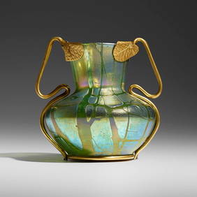
Loetz, Crete Pampas vase with applied mountToomey & Co. Auctioneers4.7(390)See Sold PriceFeb 29, 2024
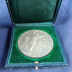
WW2 WWII German Fallschirmajager commerative medallion of crete invasionEagles Corps International LLC4.6(107)See Sold PriceMar 10, 2024
Antique Pennsylvania Map Fragment incl Wellersburg and New CentervilleCordier Auctions4.4(1.5k)See Sold PriceMar 02, 2024