ATLAS of ANTIENT GEOGRAPHY by SAMUEL BUTLER 1843John McInnis Auctioneers,LLC4.5(494)See Sold PriceFeb 24, 2024
18TH C. ANTIQUE MAP: FRENCH & INDIAN WAR, FRAMEDThomaston Place Auction Galleries4.4(386)See Sold PriceFeb 24, 2024
Rand McNally Railroad Map Cabinet w/ 21 Railroad MapsRail & Road Auctions4.6(165)See Sold PriceMar 08, 2024
Keith Haring - Ink on New York Map, Best Buddies, Inscribed, Signed, and DatedSapphire Auction Gallery3.9(67)See Sold PriceMar 02, 2024
LATE 17TH C. FRENCH MAP OF THE NEW WORLD BY ALEXIS-HUBERT JAILLOT (1632-1712)Thomaston Place Auction Galleries4.4(386)See Sold PriceFeb 24, 2024
Central Railroad of New Jersey Map of Sandy Hook Route-ca. 1903JM Hobby Supply and Railroad Artifact Auctions4.4(126)See Sold PriceFeb 24, 2024
Lot of Six Mixed Atlas Box Cars-HO Scale-New in BoxJM Hobby Supply and Railroad Artifact Auctions4.4(126)See Sold PriceFeb 25, 2024
Rand McNally/Santa Fe Railroad Map of Iowa-1912JM Hobby Supply and Railroad Artifact Auctions4.4(126)See Sold PriceFeb 24, 2024
NICOLAES VISSCHER (NETHERLANDS, 1618-1709) MAP OF THE NEW WORLDThomaston Place Auction Galleries4.4(386)See Sold PriceFeb 24, 2024
17TH C. WORLD MAP BY NICOLAES VISSCHER (NETHERLANDS, 1618-1709)Thomaston Place Auction Galleries4.4(386)See Sold PriceFeb 24, 2024
Lot of Six Mixed Atlas Cabooses-HO Scale-New in BoxJM Hobby Supply and Railroad Artifact Auctions4.4(126)See Sold PriceFeb 25, 2024
SoldEARLY MAP OF THE NORTH PACIFICEarly copper-engraved and hand-colored map of the North Pacific, 17" x 10 1/2", published circa 1779-1780, with the printer not identified. The map specifically charts the third and final voyage of exSee Sold Price
EARLY MAP OF THE NORTH PACIFICEarly hand-colored copper-plate engraved map, 22' x 32', a circa 1797 depiction of the North Pacific and the coastlines of North America and Asia as far south as Baja California and Formosa. The rubriSee Sold Price
EARLY MAP OF THE NORTH PACIFIC BY M. BONNEEarly copper-engraved map of the North Pacific, 17 1/2" x 11 1/2", published circa 1779-1780 and drafted by French hydrographic engineer M. Bonne. The map depicts the Kamchatka Peninsula, the coast ofSee Sold Price
EARLY FRENCH MAP OF THE NORTH PACIFICEarly hand-colored map of the North Pacific, 15 1/4" x 11 3/4", printed in French circa 1779-1780 by "Dupuis". The map depicts the coast of Asia from southern China to the Kamchatka Peninsula, the JapSee Sold Price
SoldMunster (Sebastian) Tabula novarum insularum, quasMunster (Sebastian) Tabula novarum insularum, quas diversis respectibus Occidentales & Indianas vocant,very early map of North and South America for the Cosmography, naming the Pacific Ocean,See Sold Price
Sold1762 JEAN JANVIER MAP OF NORTH AMERICA1762 JEAN JANVIER MAP OF NORTH AMERICA: Early map of North America featuring the ''Mer ou Baye de L'Ouest'' or ''Sea of the West'' in the Pacific Northwest. Cartouche lower left with foliate design, fSee Sold Price
SoldEarly map of California(lot of 2) unframed detailed color map of California and the Pacific coast, 12'' x 14'', together with an unframed 1831 North American map highlighting Native American tribes, 12.5'' x 17''See Sold Price
SoldNorthern Pacific Railway Yellowstone Park MapThis is a Northern Pacific Railway map of Yellowstone National Park. The map shows the very early roads and wagon trails used in the late 1800's. The top is marked "Northern Pacific Railway" and the bSee Sold Price
SoldYellowstone Park NP RR Map & Yellowstone Shaw TheThe lot includes: antique early silk Yellowstone National Park Wilderness shaw or fabric advertisement and Northern Pacific Yellowstone Park Line Map. The pamphlet shows pages of informatoin about theSee Sold Price
SoldYellowstone National Park Ephemera CollectionThis lot contains a collection of early Yellowstone National Park ephemera, including; a Northern Pacific Yellowstone Park Line magazine, three fold out maps - two of them Conoco Gasoline branded, a sSee Sold Price
de l'Isle: Antique Map North Pacific Discoveries, 1750Nouvelles decouvertes au nord de la Mer du Sud. North Pacific. This landmark map in the history of cartography shows "new discoveries" in the North Pacific Ocean by explorers seeking among other objecSee Sold Price
SoldRARE EARLY MAP OF NORTH AMERICA - Matthias Seutter,RARE EARLY MAP OF NORTH AMERICA - Matthias Seutter, copperplate engraving on laid paper, with later hand coloring, circa 1730; "Recens Edita Totius novi Belgii in America Septentrionali siti DelineatoSee Sold Price
SoldEarly Map of North AmericaEarly Map of North America. New York, New Jersey and part of Pennsylvania. c. 1776. 55" x 21 1/2". A Prominent Buffalo, NY Family.See Sold Price
SoldJansson, Important Early Map of North AmericaJanssonius, Joannes. America Septentrionalis. Amsterdam, ca 1636-47. Plate 18.25 x 21.5 in., including margins, 20.5 x 23.75 in. Hand-colored in outline and illustrations. Often cited as the earliestSee Sold Price
SoldVery Early Map of North CarolinaVery Early Map of North Carolinafrom American Pocket Atlas (Philadelphia: Matthew Carey, 1801), copperplate engraving by W. Barker, with outline color. Presented behind a mat. Sheet 8 x 9 in. AdditioSee Sold Price
De la Porte: Early Map of North America, 1786Map: L'Amerique Septentrionale Divisee en Ses Principaux Etats (scarce Early Map of North America) Cartographer: De La Porte Illustrator: De La Porte Date: 1786 Size: 7 x 8.75 inches Scarce, antique mSee Sold Price
SoldEarly Map of North AmericaEarly Map of North America Showing numerous Indian Tribes Maker: Samuel Walker - Boston Dated: Circa 1830's - 40's Type: Engraving<See Sold Price
SoldGrp: Early Maps of North America w/ 1 Map EnglandGroup of early maps of North America with one map of England. Includes Louis Brion de la Tour (1743-1803), "Amerique Septentrionale, ou se remarquent les Etats Unis," Paris, 1779; John Melish (1771-18See Sold Price
SoldEARLY MAP OF NORTH AMERICAN by LEON L HOLLANDExcellent hand drawn map of North America. Done by Leon L Holland. Framed. 30"x24" ExcellentSee Sold Price
SoldEarly Map of North AmericaEarly Map of North America Showing numerous Indian Tribes and California as a peninsula. Cartographer: Samuel Walker - Boston Dated: Circa 1830's - 40's<See Sold Price
1775 Sayer Map of North Pacific with Detail of SiberiaTitle: 1775 Sayer Map of North Pacific with Detail of Siberia -- The Russian Discoveries from the Map Published by the Imperial Academy of St. Petersburg Cartographer: R Sayer Year / Place: 1775, LondSee Sold Price
SoldRare & Early Map of North & South Carolinaby Henry Mouzon, published by Sawyer and Bennett, London, 1775. giving exceptional detail of key locations in both North & South Carolina. upper sheet: H21 1/2" W54 3/4" lower sheet: H21 1/4" W52 1/4"See Sold Price
SoldEarly Map of North AmericaHerman Moll British (1654-1732)A NEW MAP OF THE NORTH PARTS OF AMERICA CLAIMED BY FRANCE UNDRE YE NAMES OF LOUISIANA, MISSISSIPPI, CANADA, AND NEW FRANCE WITH YE ADJOYNING TERRITORIES OF ENGLAND AND SSee Sold Price
EARLY 18TH C. DUTCH CHART OF PACIFIC OCEAN BY FREDERIK DE WIT (1629-1706) WITH CALIFORNIA AS ANThomaston Place Auction Galleries4.4(386)See Sold PriceFeb 24, 2024
8 Stereoscope Cards - Great Horse Show at the Louisiana Exposition, Southern Pacific Train,North American Artifact Auctions4.7(175)See Sold PriceApr 20, 2024
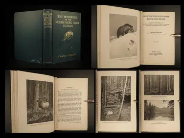
1912 HUNTING Alaska Vancouver Sheldon Wilderness of North Pacific Canada BearSchilb Antiquarian Rare Books4.8(415)See Sold PriceMar 31, 2024
Arrowsmith & Lewis - Map of PolynesiaTrillium Antique Prints & Rare Books4.5(28)See Sold PriceFeb 24, 2024
Arrowsmith & Lewis - Map of North AmericaTrillium Antique Prints & Rare Books4.5(28)See Sold PriceFeb 24, 2024
Arrowsmith & Lewis - Map of the World on Mercator's ProjectionTrillium Antique Prints & Rare Books4.5(28)See Sold PriceFeb 24, 2024
Arrowsmith & Lewis - Map of LouisianaTrillium Antique Prints & Rare Books4.5(28)See Sold PriceFeb 24, 2024
Arrowsmith & Lewis - Map of the United StatesTrillium Antique Prints & Rare Books4.5(28)See Sold PriceFeb 24, 2024
Carey, pub. 1796 - Map of the Tennassee State formerly part of North Carolina (Tennessee)Trillium Antique Prints & Rare Books4.5(28)See Sold PriceFeb 24, 2024
Blackie (Pub) 1882 Folio Map. West USA - Pacific StatesAlbion Auctions4.7(335)See Sold PriceMar 01, 2024