ATLAS of ANTIENT GEOGRAPHY by SAMUEL BUTLER 1843John McInnis Auctioneers,LLC4.5(505)See Sold PriceFeb 24, 2024
18TH C. ANTIQUE MAP: FRENCH & INDIAN WAR, FRAMEDThomaston Place Auction Galleries4.4(393)See Sold PriceFeb 24, 2024
Rand McNally Railroad Map Cabinet w/ 21 Railroad MapsRail & Road Auctions4.6(165)See Sold PriceMar 08, 2024
Keith Haring - Ink on New York Map, Best Buddies, Inscribed, Signed, and DatedSapphire Auction Gallery4.1(67)See Sold PriceMar 02, 2024
LATE 17TH C. FRENCH MAP OF THE NEW WORLD BY ALEXIS-HUBERT JAILLOT (1632-1712)Thomaston Place Auction Galleries4.4(393)See Sold PriceFeb 24, 2024
Central Railroad of New Jersey Map of Sandy Hook Route-ca. 1903JM Hobby Supply and Railroad Artifact Auctions4.4(127)See Sold PriceFeb 24, 2024
Lot of Six Mixed Atlas Box Cars-HO Scale-New in BoxJM Hobby Supply and Railroad Artifact Auctions4.4(127)See Sold PriceFeb 25, 2024
Rand McNally/Santa Fe Railroad Map of Iowa-1912JM Hobby Supply and Railroad Artifact Auctions4.4(127)See Sold PriceFeb 24, 2024
NICOLAES VISSCHER (NETHERLANDS, 1618-1709) MAP OF THE NEW WORLDThomaston Place Auction Galleries4.4(393)See Sold PriceFeb 24, 2024
17TH C. WORLD MAP BY NICOLAES VISSCHER (NETHERLANDS, 1618-1709)Thomaston Place Auction Galleries4.4(393)See Sold PriceFeb 24, 2024
Lot of Six Mixed Atlas Cabooses-HO Scale-New in BoxJM Hobby Supply and Railroad Artifact Auctions4.4(127)See Sold PriceFeb 25, 2024
Map of the World On Mercator's Projection. by David H.Reserve Reduced! Title: Map of the World On Mercator's Projection. by David H. Burr. ... Publication Date: c1850 Cartographer: BURR, DAVID H. Publisher: S.W. CHANDLER & BRO. Size (inches): 17.1 x 21 ASee Sold Price
Map of the World On Mercator's Projection. by David H.Title: Map of the World On Mercator's Projection. by David H. Burr. ... Publication Date: c1850 Publisher: S.W. CHANDLER & BRO. Size: 17.1 x 21 A good quality steel engraved Burr wall map surrounded wSee Sold Price
Rare Small School Wall Map With Current Events;Burr, David H. (1803-1875). Map of the World on Mercator's Projection. Engraved map. S. W. chandler & Bro., c. 1850. 17 â…›" x 21" sheet. A good quality steel engraved Burr wall map surrounded wiSee Sold Price
SoldThe World, on Mercator's Projection 1850Heading: Author: Burr, David H. Title: The World, on Mercator's Projection Place Published: Boston Publisher:J. Haven Date Published: 1850 Description: Map size: 46x57 cm (18x22See Sold Price
Colton's New Illustrated Map Of The WorlColton's New Illustrated Map Of The World, On Mercator's Projection Published by J. H. Colton & Co., #172 William Street, New York, 1856; map has been laid to board and has crinkling. frame size: H34See Sold Price
1831 Teesdale World Map -- The World on Mercator'sTitle: 1831 Teesdale World Map -- The World on Mercator's Projection Date: 1831, London Cartographer: H Teesdale Size: 13.2 X 16.1 in. Additional Information: This is a very nice World Map.The northerSee Sold Price
Hart: Map of World On Mercator's Projection, 1828Title/Content of Map: World On Mercator's Projection Date Printed: 1828 Cartographer: HART, JOSEPH C./J. H. YOUNG Size (inches): 13.8x10.3 "Drawn & engraved to illustrate HART'S geographical exercisesSee Sold Price
Colton: Map of the World On Mercator's Projection, 1855Map of the World On Mercator's Projection. JOSEPH HUTCHINS COLTON, 1855, Folio – 16.75 H x 25.50 W Inches, Large double-page world map with leaf of text. Shows major voyage routes of famous explorerSee Sold Price
SoldFramed Map of the World in Mercator ProjectionFramed map of the world in Mercator Projection. Dated 1987. Printed by the American Map Company. 62" W x 39 1/2" H.See Sold Price
Scherer (H.). Iter S. Francisci Xaverii [...]Scherer (Heinrich) Iter S. Francisci Xaverii ex Europa in India, & Japoniam, world map on Mercator's projection, from Atlas Novus, showing California as an island, vignette shipping scenesSee Sold Price
Framed Map of the World in Mercator ProjectionFramed map of the world in Mercator Projection. Dated 1987. Printed by the American Map Company. 62" W x 39 1/2" H.See Sold Price
SoldMap of The World On Mercators Projection, 1848Map: The World On Mercators Projection Size: Folio – 11.00 H x 13.20 W Inches Publisher: Orr & Sons & J. Morrison 1848 London/Glasgow From Edinburgh General Atlas. Shows Texas labeled in the North ASee Sold Price
World On Mercator's ProjectionReserve Reduced! Title/Content of Map: World On Mercator's Projection Date: 1828 Cartographer: HART, JOSEPH C./J. H. YOUNG Material/Medium: R. LOCKWOOD, etc. Size: 12.3Height - 14.8Width Drawn & engraSee Sold Price
SoldMercators Projections 1892 map of the WorldMercators Projections 1892 map of the World. 21"h x 27" wSee Sold Price
SoldChart of the World On Mercators Projection, 1796Map: Chart of the World On Mercators Projection Maker: Thomas & Andrews, Morse/Doolittle (Sculp) Publisher: Boston, 1796 Size: Quarto - 7.30 H x 10.00 W Inches Small map of the world. Shows LouisianaSee Sold Price
World On Mercator's ProjectionTitle: World On Mercator's Projection Publication Date: 1828 Cartographer:HART, JOSEPH C./J. H. YOUNG Publisher: R. LOCKWOOD, etc. Brief Description: "Drawn & engraved to illustrate HART'S geographicaSee Sold Price
SoldEMANUEL BOWEN, MAP PRINT "A NEW & CORRECT CHART"EMANUEL BOWEN, MAP PRINT, H 15", W 18", "A NEW & CORRECT CHART OF ALL THE KNOWN WORLD": Complete title "A New And Correct Chart of all the Known Word Laid down according to Mercator's Projection ExhibSee Sold Price
Sold(3) MAPS, MERCATOR'S PROJECTION, WESTERN EUROPEAntique maps: (1) framed map of the West Indies from George Washington Colton's 1855 Atlas of the World, page 56, Bermuda Islands inset at upper right above the Havana harbor, sight: 13.5"h, 16.5"w, oSee Sold Price
Tallis World Map World on Mercator's Projection 1851Tallis World Map The World on Mercator's Projection 1851. T. Jefferys, 1757 London, 6 X 10.6 In.. This Is an Attractive and Charming Double Hemisphere Map, Colored, and Framed. it Is Set Against a BacSee Sold Price
SoldMap World of Mercator's Projection John TallesMap World of Mercator's Projection John Talles - drawn & engraved by J. RapkinSee Sold Price
SoldTallis World Map World on Mercator's Projection 1851Tallis World Map The World on Mercator's Projection 1851 . J. Tallis, 1851 London, 10.5 X 14 In.. This Is a Decorative and Striking Steel Engraved World Map That Was Produced from the Same Plate UsedSee Sold Price
SoldGuthrie, William 1798 Map World of Mercators ProjectionCopper Engraved Map Published 1798, London for "A New Geographical, Historical and Commercial Grammar..." by William Guthrie. The maps are by John Senex, Thomas Kitchin and others. Folds as issued. PaSee Sold Price
SoldRapkin, John 1860 Map. World on Mercator's ProjectionSteel Engraved Map Published 1860 by The London Printing & Published Company, London for "The Royal Dictionary-Cyclopedia for Universal Reference" by Thomas Wright. Drawn & Engraved by John Rapkin. FoSee Sold Price
SoldRapkin, John 1860 Map. World on Mercator's ProjectionSteel Engraved Map Published 1860 by The London Printing & Published Company, London for "The Royal Dictionary-Cyclopedia for Universal Reference" by Thomas Wright. Drawn & Engraved by John Rapkin. FoSee Sold Price
Arrowsmith & Lewis - Map of the World on Mercator's ProjectionTrillium Antique Prints & Rare Books4.5(32)See Sold PriceFeb 24, 2024
Carey, pub. 1796 - A Chart of the West IndiesTrillium Antique Prints & Rare Books4.5(32)See Sold PriceFeb 24, 2024
Carey, pub. 1796 - Map of the State of MarylandTrillium Antique Prints & Rare Books4.5(32)See Sold PriceFeb 24, 2024
Carey, pub. 1796 - Map of GeorgiaTrillium Antique Prints & Rare Books4.5(32)See Sold PriceFeb 24, 2024
Carey, pub. 1796 - Map of The State of South CarolinaTrillium Antique Prints & Rare Books4.5(32)See Sold PriceFeb 24, 2024
Carey, pub. 1796 - Map of KentuckyTrillium Antique Prints & Rare Books4.5(32)See Sold PriceFeb 24, 2024
Carey, pub. 1796 - Map of the Tennassee State formerly part of North Carolina (Tennessee)Trillium Antique Prints & Rare Books4.5(32)See Sold PriceFeb 24, 2024
De Jode, Rare, pub. 1593 - Map of Africa (Africae Vera Forma, et Situs)Trillium Antique Prints & Rare Books4.5(32)See Sold PriceFeb 24, 2024
1738 BIBLE in DUTCH ILLUSTRATED w/ MAPS antique MASSIVE FOLIO BIBLIAJasper524.5(9.9k)See Sold PriceFeb 27, 2024
1730 BIBLE in DUTCH ILLUSTRATED w/ MAPS antique MASSIVE FOLIO BIBLIAJasper524.5(9.9k)See Sold PriceFeb 27, 2024
Georg Bockler Map of Ancient Jerulsaem EtchingAuctions at Showplace4.6(740)See Sold PriceApr 07, 2024
Blackie (Pub) 1882 Folio Map. World on Mercators ProjectionAlbion Auctions4.7(341)See Sold PriceMar 01, 2024
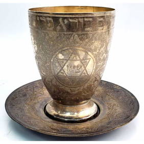
Judaica Persian Silver Kiddish Cup and UnderplateWorld Auction Gallery LLC4.7(264)See Sold PriceMar 10, 2024
1995 Massive World Map Custom-Made Coffee TableGLOBAL NETWORTH AUCTIONS4(35)See Sold PriceMar 03, 2024


![Scherer (H.). Iter S. Francisci Xaverii [...] (1 of 1)](https://p1.liveauctioneers.com/410/21399/7337489_1_x.jpg?height=282&quality=70)