ATLAS of ANTIENT GEOGRAPHY by SAMUEL BUTLER 1843John McInnis Auctioneers,LLC4.6(504)See Sold PriceFeb 24, 2024
18TH C. ANTIQUE MAP: FRENCH & INDIAN WAR, FRAMEDThomaston Place Auction Galleries4.4(389)See Sold PriceFeb 24, 2024
Rand McNally Railroad Map Cabinet w/ 21 Railroad MapsRail & Road Auctions4.6(165)See Sold PriceMar 08, 2024
Keith Haring - Ink on New York Map, Best Buddies, Inscribed, Signed, and DatedSapphire Auction Gallery4.1(67)See Sold PriceMar 02, 2024
LATE 17TH C. FRENCH MAP OF THE NEW WORLD BY ALEXIS-HUBERT JAILLOT (1632-1712)Thomaston Place Auction Galleries4.4(389)See Sold PriceFeb 24, 2024
Central Railroad of New Jersey Map of Sandy Hook Route-ca. 1903JM Hobby Supply and Railroad Artifact Auctions4.4(126)See Sold PriceFeb 24, 2024
Lot of Six Mixed Atlas Box Cars-HO Scale-New in BoxJM Hobby Supply and Railroad Artifact Auctions4.4(126)See Sold PriceFeb 25, 2024
Rand McNally/Santa Fe Railroad Map of Iowa-1912JM Hobby Supply and Railroad Artifact Auctions4.4(126)See Sold PriceFeb 24, 2024
NICOLAES VISSCHER (NETHERLANDS, 1618-1709) MAP OF THE NEW WORLDThomaston Place Auction Galleries4.4(389)See Sold PriceFeb 24, 2024
17TH C. WORLD MAP BY NICOLAES VISSCHER (NETHERLANDS, 1618-1709)Thomaston Place Auction Galleries4.4(389)See Sold PriceFeb 24, 2024
Lot of Six Mixed Atlas Cabooses-HO Scale-New in BoxJM Hobby Supply and Railroad Artifact Auctions4.4(126)See Sold PriceFeb 25, 2024
SoldRetrospective of Maps Depicting CyprusRetrospective of Maps Depicting CyprusMaps of Cyprus From the Collections of the Bank of Cyprus Cultural Foundation, Leonora Navari, ed. (Nicosia: Bank of Cyprus Cultural Foundation, 2003), 373 pp. quSee Sold Price
Giacomo Cantelli da Vignola. Natolia Detta anticGiacomo Cantelli da Vignola. Natolia Detta anticamente Asia Minore.See Sold Price
Giacomo Cantelli da Vignola. Asiae Minoris. RomaGiacomo Cantelli da Vignola. Asiae Minoris. Roma: 1See Sold Price
Sold20st Century Middle Eastern Persian Miniature Depicting the Map of CyprusDescription: 20th century Middle Eastern Persian miniature depicting the map of Cyprus, 27 x 36,5 cm. The item will be shipped in a protective tube. Condition: in very good condition Inhouse worldwideSee Sold Price
Sold(MAP) CAMOCIO Size of frame 21 x 15 inches.(MAP) CAMOCIO A group of two maps framed together. By Francesco Camocio. From an edition of Isole famose. Venice, c. 1560 depicting Cyprus and the Morea. Size of frame 21 x 15 inches.See Sold Price
SoldOrtelius, Abraham. Insular. Aliquot Aegaei Marisdated 1584, from Theatrum Orbis Terrarum (Antwerp, late 16th century), copperplate engraving, depicting Cyprus and prominent Aegean islands, verso with Latin text, one page with XXX pagination. UnframSee Sold Price
Soldc. 1592 Pilgrimage of St Paul, Abraham Ortelius [Map]Colored map by Abraham Ortelius depicting the pilgrimage of St. Paul and printed in Antwerp in the year 1592. Map covers the Mediterranean Sea region between Israel and Sicily with Cyprus, Italy, GrSee Sold Price
SoldCOLLECTION OF 38 16TH CENTURY MAPS DEPICTINGEUROPEAN CITIES SUCH AS CADIZ, BARCINO, BLANMONT, AURELLA, THEMAE, DUACUM, MONTES, CAMPENA, VERONA. MANY OF THEM ARE DATED 1581, PROBABLY TAKEN FROM AN ATLAS, PAGES ARE JOINED TOGETHER. THERE IS WATERSee Sold Price
SoldAntique Maps: Collection of Five Map Depicting VariousAll unframed. Largest: 14" wd x 8.5" ht.See Sold Price
SoldOrtelius Antique Map: Cyprus Insula, Candia Olim CretaTitle/Content of Map: Cyprus Insula, Candia Olim Creta Date Printed: 1579 Cartographer: Abraham Ortelius Material/Medium: No color, good impression. Latin text on verso. From the first modern atlas- tSee Sold Price
Soldc1844 HAND TINTED U.S. United States MAP DEPICTING -c1844 HAND TINTED U.S. United States MAP DEPICTING - MICHIGAN WISCONSIN, PART IA c1844 HAND TINTED U.S. United States MAP DEPICTING - MICHIGAN WISCONSIN, PART IA Description Circa 1844 Hand Tinted WatSee Sold Price
SoldEight Maps Depicting the Journeys of the Children ofEight maps depicting the journeys of the Children of Israel, the entrance into the Land and its tribal division - etches. Various etches, 18-19th centuries. *Â The Forty Years of Travels of the ChilSee Sold Price
Three Framed Maps Depicting EuropeIncluding: Guillaume DeLisle, "The Seat of War on The Rhine being a New Map of the Course of the River from Strasbourg to Bonn," John Senex, "The New Map of Italy," and John Senex, "A New and CorrectSee Sold Price
SoldScarce 1818 Map depicting the Battle of Bunker Hill drawn by witness Henry DeBernier, a soldier inScarce 1818 Map depicting the Battle of Bunker Hill drawn by witness Henry DeBernier, a soldier in the 10th regiment of infantry. "Sketch of the Action on the Heights of Charlestown 17 June 1775 BetweSee Sold Price
SoldCollection of maps depicting the British Isles, EnglandCollection of maps depicting the British Isles, England and Wales (qty) - Stock Ref:255-41See Sold Price
Soldc1844 HAND TINTED U.S. United States MAP DEPICTINGc1844 HAND TINTED U.S. United States MAP DEPICTING CENTRAL STATES VA OH KY PA MD c1844 HAND TINTED U.S. United States MAP DEPICTING CENTRAL STATES VA OH KY PA MD Description Circa 1844 Hand Tinted WatSee Sold Price
SoldLot of 45 maps depicting Texas105. [MAP]. TEXAS. Lot of 45 maps, all depicting Texas, at least in part, mostly nineteenth and early twentieth century with approximately 10 twentieth-century facsimiles. Various plSee Sold Price
Sold(EUROPA REGINA.) Two early maps depicting the European(EUROPA REGINA.) Two early maps depicting the European continent as a Queenly personification. Vp, vd Münster, Sebastian. [Europa Regina.] Woodcut, 13½x8¾ inches sheet size, German textSee Sold Price
Sold* Two Maps Depicting Missouri* Two Maps Depicting Missouri G.W. & C.B. COLTON & CO. (MAP) Colton's Missouri. New York. Lithograph with hand-coloring. Framed. BRINK McDONOUGH & CO. Township & Railroad Map of MisSee Sold Price
Sold4 maps depicting the Russian Empiure42” x 29” Frame size, 4 maps depicting the Russian Empiure, in colors, published by W.H. Lizars Edinburgh - will not shipSee Sold Price
SoldTwo Antique French Maps Depicting Near Eastern LandsTwo Antique French Maps Depicting Near Eastern Landsas follows: Terrae Sanctae Tabuls (Paris: Joseph De L'Isle, 1763), copperplate engraving with outline color, after the writings of Flavius Josephus,See Sold Price
SoldA RARE PRINT OF A MAP DEPICTING PARTS OF THE ARABIAN GULF INCLUDING QATAR FROM 1874A RARE PRINT OF A MAP DEPICTING PARTS OF THE ARABIAN GULF INCLUDING QATAR FROM 1874L: 60cm , H: 42cmSee Sold Price
SoldA map depicting the The relative part of Jews in theThe Economic Structure of the Jewish and Non-Jewish Population in Poland. A map describing the relative share of Jews in the various economic sectors, vis-à-vis non-Jews in Poland, 1921-1928. YSee Sold Price
WILLEM JANSZOON BLAEU (NETHERLANDS, 1571-1638) MAP OF UMBRIAThomaston Place Auction Galleries4.4(389)See Sold PriceFeb 24, 2024
ALKEN / ACKERMAN Original Equestrian Aquatint Victorious Bunchclod c1847 FramedLuis Porretta Fine Arts4.3(10)See Sold PriceMar 02, 2024
A quantity of World War II / Two military ephemera to include assorted 1940s newspapers pages toClaydon Auctioneers Ltd4.3(125)See Sold PriceFeb 26, 2024
World map.- Macrobius (Ambrosius Aurelius Theodosius) In somnium Scipionis, Libri II. Saturnaliorum,Forum Auctions4.3(53)See Sold PriceFeb 29, 2024
Theodor Fischer (1862 - 1938) - Set of 4 Bird Prints - Haliaetos Albicilla - Strix LapponicaProverde Auctions4.3(3)See Sold PriceFeb 28, 2024
Henri Plon - Set of 4 topographical prints depicting Asia and JapanProverde Auctions4.3(3)See Sold PriceFeb 28, 2024
Henri Plon - Set of 20 topographical prints depicting Asia - Japan - China - Religious building -Proverde Auctions4.3(3)See Sold PriceFeb 28, 2024
Carl Johan Billmark - Set of 4 Prints depicting Rome, Italy - Church in Sweden - Views of EuropeProverde Auctions4.3(3)See Sold PriceFeb 28, 2024
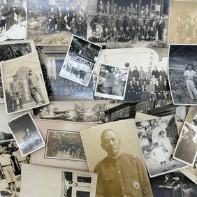
Photography - Set of 30 Photos from Japan - Group photographs and portraits of Japanese peopleProverde Auctions4.3(3)See Sold PriceFeb 28, 2024


![c. 1592 Pilgrimage of St Paul, Abraham Ortelius [Map] (1 of 8)](https://p1.liveauctioneers.com/7226/294713/156486872_1_x.jpg?height=282&quality=70&version=1688308989)