ATLAS of ANTIENT GEOGRAPHY by SAMUEL BUTLER 1843John McInnis Auctioneers,LLC4.6(504)See Sold PriceFeb 24, 2024
18TH C. ANTIQUE MAP: FRENCH & INDIAN WAR, FRAMEDThomaston Place Auction Galleries4.4(389)See Sold PriceFeb 24, 2024
Rand McNally Railroad Map Cabinet w/ 21 Railroad MapsRail & Road Auctions4.6(165)See Sold PriceMar 08, 2024
Keith Haring - Ink on New York Map, Best Buddies, Inscribed, Signed, and DatedSapphire Auction Gallery4.1(67)See Sold PriceMar 02, 2024
LATE 17TH C. FRENCH MAP OF THE NEW WORLD BY ALEXIS-HUBERT JAILLOT (1632-1712)Thomaston Place Auction Galleries4.4(389)See Sold PriceFeb 24, 2024
Central Railroad of New Jersey Map of Sandy Hook Route-ca. 1903JM Hobby Supply and Railroad Artifact Auctions4.4(126)See Sold PriceFeb 24, 2024
Lot of Six Mixed Atlas Box Cars-HO Scale-New in BoxJM Hobby Supply and Railroad Artifact Auctions4.4(126)See Sold PriceFeb 25, 2024
Rand McNally/Santa Fe Railroad Map of Iowa-1912JM Hobby Supply and Railroad Artifact Auctions4.4(126)See Sold PriceFeb 24, 2024
NICOLAES VISSCHER (NETHERLANDS, 1618-1709) MAP OF THE NEW WORLDThomaston Place Auction Galleries4.4(389)See Sold PriceFeb 24, 2024
17TH C. WORLD MAP BY NICOLAES VISSCHER (NETHERLANDS, 1618-1709)Thomaston Place Auction Galleries4.4(389)See Sold PriceFeb 24, 2024
Lot of Six Mixed Atlas Cabooses-HO Scale-New in BoxJM Hobby Supply and Railroad Artifact Auctions4.4(126)See Sold PriceFeb 25, 2024
SoldLot of (6) antiquarian mapsLot of (6) antiquarian maps, c/o "The Century Atlas: England and Wales, Northern Part" (Buffalo: Matthews-Northrup Co 1897); "The Century Atlas: England and Wales, Southern Part" (Buffalo: Matthews-NoSee Sold Price
Sold6 antiquarian maps of Ireland and Great BritainLot of (6) antiquarian maps of Ireland and Great BritainSee Sold Price
SoldStieler, Adolph 1905 Lot 6 Maps South America & MexicoIncl Mexico, South America Continent, and several sheets showing parts of South America. Lithograph Maps Published 1905 by Justus Perthes, Gotha for "Stielers Hand-Atlas" by Adolf Stieler. Centre foldSee Sold Price
SoldLOT (6) MAPS-WORLD AND THE CONTINENTS, JOHN WALKERLOT (6) MAPS-WORLD AND THE CONTINENTS, JOHN WALKER DUBLIN, C.1788. (1) 7 3/8 X 12 1/2"; FRAMED AND GLAZED 15 X 20"; (5) 7 1/2 X 9", FRAMED AND GLAZED 15 X 16 1/2"See Sold Price
SoldEphemera Lot #6Ephemera Lot #6: Map of Palestine, no date, apparently a page removed from an atlas and mounted on foam board, sealed in plastic. Areas marked Judea, Samaria, Galilee, Perea. Colorized. VGSee Sold Price
SoldGeology 1833-64 Lot of 6 Maps and PrintsMaps mosly of Europe and British Isles but one plate showing Asia/Mexico/Holy Land. Copper Engraved Maps Published 1817-45, London for "Encyclopaedia Metropolitana" by Samuel Taylor Coleridge el al anSee Sold Price
SoldBartholomew, John 1922 Lot of 6 Maps of the AmericasIncl Mexico, West Indies, South America Political, South America North, South America South, and Argentina/Chile. Large Lithograph Maps Published 1922 by The Times, London for "The Times Survey AtlasSee Sold Price
SoldLot of 6 Maps of Africa 1618-1813Guinea (under heading: Descriptio Gvineæ.) By Petrus Kerius Pieter van der Keere For atlas of Petrus Bertius (Pieter de Bert), Amsterdam, 1618 , page 652. 9 cm x 13 cm Watermarked paper. Small faSee Sold Price
SoldThe Times 1895 Mixed Lot of 6 MapsIncl Australia and New Zealand, England and Wales (South and North) Africa North East, Africa North West, and India North. Lithograph Maps Published 1895, London for "The Times Atlas" Paper Size: 21 xSee Sold Price
SoldMixed Maps 1780's-C1870 Mixed Lot of 6 MapsIncl Barnard Castle, Roman Empire, Battle of Alexandria, Siege of Toulon, Europe, and Central & Southern Europe. Examples by Grose, Alison & Johnson, Hughes, Stieler and Sidney Hall. Paper Size: Up toSee Sold Price
SoldA lot of 6 Maps of Israel and Jerusalemsix framed maps engravings and copies of Israel and Jerusalem. Made according to maps from the 17th and 18th century. All of the maps are in good condition and in quality framing.See Sold Price
SoldAfrica 1881-1992 Lot of 6 Maps by BartholomewIncl Cape Colony, Central/Southern Africa, Africa Political, Cape Province/Transvaal - East and West, and South Africa. Large Lithograph Maps Published 1922 by The Times, London for "The Times SurveySee Sold Price
SoldBlackie & Weller 1882 Lot of 6 Maps of EuropeIncl Europe Continent, France, Central Europe, German Empire West Sheet, German Empire East Sheet, and The Austrian Empire. Lithograph Maps Published 1882 by Blackie & Son, London for "The ComprehensiSee Sold Price
SoldTurkey & Greece 19th Century Lot of 6 MapsMostly Turkey. Examples by Cornwell/Dower, Becker, and Chambers. Paper Size: Up to 12 x 9.5 inch (30 x 24cm) Some small faults in parts, good overallSee Sold Price
SoldEstevanez, Nicolas C1910 Lot of 6 Maps of South AmericaIncl South America Continent, Peru, Bolivia, Columbia/Ecuador, Brazil and Uruguay. Lithograph Maps Published C1910, Paris for "Atlas Geografico de America" by Nicolas Estevanez. Centre fold as issued.See Sold Price
SoldBrockhaus (Pub) 1890's Lot of 6 Maps of GermanyIncl Elberfeld, German Dialects, Military Positions, Dresden, and Bayern. Lithograph Maps Published 1892-98 by F. A. Brockhaus, Leipzig for "Brockhaus' Konversations-Lexikon" by Various. Paper Size: USee Sold Price
SoldGroup Lot of 6 MapsSix Map Lot 1. Cram's Railroad and Township Map of Montana. George Cram. Lithograph with hand color. Chicago: Cram, 1879. 21 3/4 x 34 inches sheet, 33 x 45 inches framed 2. Map of Montana. Rand McNallSee Sold Price
Sold[CEYLON] A lot of 6 mapsMAPS OF CEYLON. A lot of 6 maps Including: Sanson, N. CEYLON EN DE MALDIVE SCH EILANDEN. Engraved map, centre fold, minor imperfections,good condition, 8.5 x 24.5. [1705] ** Samuel Purchas. NECIUS VOYSee Sold Price
UK C1830-1948 Mixed Lot of 6 MapsEngraved and Lithographed Maps. Incl Staffordshire, Huddersfield, Navigable Rivers, Buckingham, London and England. Examples by Ordnance Survey, Sidney Hall, Encyclopaedia Britannica, National EncycloSee Sold Price
SoldSohio/Boron MapsSohio/Boron Maps, this Job lot contains 6 maps, all in great condition.See Sold Price
SoldFrench 18th C. Map of the WorldGROUP LOT OF 6 MAPS WITH FINE ORIGINAL COLOR Louis Brion de la Tour (c. 1743 – 1803) from Louis C. Desnos' Atlas General Engraved maps with hand color in full Paris, 1779 (1783) each approximately 2See Sold Price
De La Tour Continents Maps*** START PRICE IS THE RESERVE *** [World] DE LA TOUR, Louis Brion (c. 1743 - 1803). Group lot of 6 maps (1. World and 5 Continents). Engraved maps with original hand color. From Louis C. Desnos' AtlaSee Sold Price
SoldLevasseur, Victor 1869 Lot 6 HC Decorative Maps FranceHand Coloured Steel Engraved Decorative Maps Published C1850, Paris for "Atlas National Illustre" by Victor Levasseur. Paper Size: 20.5 x 15 inch (52 x 38cm) Good ConditionSee Sold Price
Guinea-Bissau Cacheu town Fortaleza de São José da Amura Preparing cassava 1745Jasper524.5(9.8k)See Sold PriceFeb 28, 2024
AFRICA. Antiqua; Rome Carthage, start Punic War 1908 old antique map chartJasper524.5(9.8k)See Sold PriceFeb 28, 2024
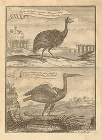
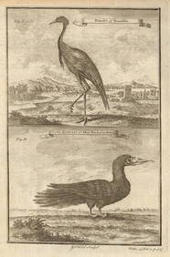
Pintado or Guinea-Hen. African Swan, or Gambian Stork. West African birds 1745Jasper524.5(9.8k)See Sold PriceFeb 28, 2024
West coast of Africa from Cape Blanco… Arguin bay, Mauritania. LABAT 1745 mapJasper524.5(9.8k)See Sold PriceFeb 28, 2024
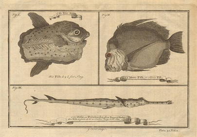
Ocean sunfish. Opah Moonfish. Orsie Petinbuaba Filefish. West African Fish 1745Jasper524.5(9.8k)See Sold PriceFeb 28, 2024
Partie de la Coste d'Afrique'. Southern Mauritania BELLIN/SCHLEY 1747 old mapJasper524.5(9.8k)See Sold PriceFeb 28, 2024
Coast & Islands between Cape Roxo. Guinea-Bissau & Bissagos. KITCHIN 1745 mapJasper524.5(9.8k)See Sold PriceFeb 28, 2024
West African birds. Ostrich pelican spoonbill bird of paradise. SCHLEY 1747Jasper524.5(9.8k)See Sold PriceFeb 28, 2024
West African fruit. Kola nut. Guava fruit. Kalabash Calabash tree 1745 printJasper524.5(9.8k)See Sold PriceFeb 28, 2024
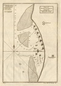
Plan du Portendic, appellé aussi…' Portendick Mauritania BELLIN/SCHLEY 1747 mapJasper524.5(9.8k)See Sold PriceFeb 28, 2024
Western Sahara. Africa 1885 old antique vintage map plan chartJasper524.5(9.8k)See Sold PriceFeb 28, 2024
Eastern Sahara. Africa. Libya Niger Algeria Chad Nigeria 1885 old antique mapJasper524.5(9.8k)See Sold PriceFeb 28, 2024
Central Africa. Congo Zambia Tanzania Kenya Mozambique. BARTHOLOMEW 1886 mapJasper524.5(9.8k)See Sold PriceFeb 28, 2024
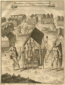
Sepulture of the Kings in Guinea'. Beheadings. Executions. After DE BRY 1746Jasper524.5(9.8k)See Sold PriceFeb 28, 2024
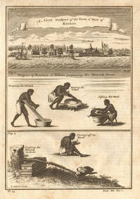
BENIN TOGO GHANA COAST. 'Kingdoms of Koto, Popo, Fida/Whydah & Ardra' 1746 mapJasper524.5(9.8k)See Sold PriceFeb 28, 2024
West African Birds. Crane Demoiselle. Alcatrazi or Mad-Bird. Albatross 1745Jasper524.5(9.8k)See Sold PriceFeb 28, 2024
West Africa. Hammerhead shark. Gambian insects. Ocean Sunfish. SCHLEY 1747Jasper524.5(9.8k)See Sold PriceFeb 28, 2024
Plan of Portendic… Portu d'Addi or Penia. Portendick Mauritania. LABAT 1745 mapJasper524.5(9.8k)See Sold PriceFeb 28, 2024
Western coast of Africa… to the River Sanaga. Southern Mauritania LABAT 1745 mapJasper524.5(9.8k)See Sold PriceFeb 28, 2024
Hottentots Namaquas'. Khoikhoi people of Namaqualand. Namibia/South Africa 1748Jasper524.5(9.8k)See Sold PriceFeb 28, 2024
SOUTHERN AFRICA. 'Namaqua Hottentots'. Khoikhoi. Namibia. From TACHARD 1746Jasper524.5(9.8k)See Sold PriceFeb 28, 2024
AFRICA. Elephant in the Pitfall (Field Sports- Edward Orme) 1814 old printJasper524.5(9.8k)See Sold PriceFeb 28, 2024
West Africa gold trinkets worn as spells and utensils. jewels ornaments 1745Jasper524.5(9.8k)See Sold PriceFeb 28, 2024
Rees & Macpherson 1820 Lot of 6 Ancient Geography MapsAlbion Auctions4.6(341)See Sold PriceMar 01, 2024


![[CEYLON] A lot of 6 maps (1 of 1)](https://p1.liveauctioneers.com/1124/187577/94368857_1_x.jpg?height=282&quality=70&version=1607095126)