ATLAS of ANTIENT GEOGRAPHY by SAMUEL BUTLER 1843John McInnis Auctioneers,LLC4.5(505)See Sold PriceFeb 24, 2024
18TH C. ANTIQUE MAP: FRENCH & INDIAN WAR, FRAMEDThomaston Place Auction Galleries4.4(393)See Sold PriceFeb 24, 2024
Rand McNally Railroad Map Cabinet w/ 21 Railroad MapsRail & Road Auctions4.6(165)See Sold PriceMar 08, 2024
Keith Haring - Ink on New York Map, Best Buddies, Inscribed, Signed, and DatedSapphire Auction Gallery4.1(67)See Sold PriceMar 02, 2024
LATE 17TH C. FRENCH MAP OF THE NEW WORLD BY ALEXIS-HUBERT JAILLOT (1632-1712)Thomaston Place Auction Galleries4.4(393)See Sold PriceFeb 24, 2024
Central Railroad of New Jersey Map of Sandy Hook Route-ca. 1903JM Hobby Supply and Railroad Artifact Auctions4.4(127)See Sold PriceFeb 24, 2024
Lot of Six Mixed Atlas Box Cars-HO Scale-New in BoxJM Hobby Supply and Railroad Artifact Auctions4.4(127)See Sold PriceFeb 25, 2024
Rand McNally/Santa Fe Railroad Map of Iowa-1912JM Hobby Supply and Railroad Artifact Auctions4.4(127)See Sold PriceFeb 24, 2024
NICOLAES VISSCHER (NETHERLANDS, 1618-1709) MAP OF THE NEW WORLDThomaston Place Auction Galleries4.4(393)See Sold PriceFeb 24, 2024
17TH C. WORLD MAP BY NICOLAES VISSCHER (NETHERLANDS, 1618-1709)Thomaston Place Auction Galleries4.4(393)See Sold PriceFeb 24, 2024
Lot of Six Mixed Atlas Cabooses-HO Scale-New in BoxJM Hobby Supply and Railroad Artifact Auctions4.4(127)See Sold PriceFeb 25, 2024
SoldWALLING 1958 MAP TITLED BARNSTABLE, DUKES AND NANTUCKETBased upon the trigometrical survey of the State, the details from actual surveys under the direction of Henry F. Walling. Engraved, colored and mounted by H.F. Walling, published by D.R. Smith & Co.See Sold Price
SoldMap of Barnstable, Dukes and Nantucket Counties, dRare map by Walling dated 1858 of Barnstable, Dukes and Nantucket Counties, Massachusetts. Detailed village views of Brewster, Chatham, Dennis, Eastham, Falmouth, Harwich, Mashpee, Orleans, ProvincetoSee Sold Price
Map of Barnstable, Dukes and Nantucket Counties, d"Rare map by Walling dated 1858 of Barnstable, Dukes and Nantucket Counties, Massachusetts. Detailed village views of Brewster, Chatham, Dennis, Eastham, Falmouth, Harwich, Mashpee, Orleans, ProvincetSee Sold Price
SoldMap of Barnstable, Dukes and Nantucket Counties, 1858Rare map by Walling dated 1858 of Barnstable, Dukes and Nantucket Counties, Massachusetts. Detailed village views of Brewster, Chatham, Dennis, Eastham, Falmouth, Harwich, Mashpee, Orleans, ProvincetoSee Sold Price
Cape Cod, Nantucket & Martha's Vineyard. Barnstable Dukes. WALLING GRAY 1871 mapTitle: Cape Cod, Nantucket & Martha's Vineyard. Barnstable Dukes. WALLING GRAY 1871 map Description: Barnstable, Dukes, Nantucket counties' by Henry Francis Walling & Ormando Willis Gray (1871). AntiqSee Sold Price
Sold"MAP OF THE COUNTIES OF BARNSTABLE, DUKES AND"MAP OF THE COUNTIES OF BARNSTABLE, DUKES AND NANTUCKET, MASSACHUSETTS."Dated 1858Survey by Henry F. Walling. Published by D.R. Smith & Co., Boston. Linen backed.62" x 60.5".See Sold Price
Sold1858 LINEN BACKED. BARNSTABLE, DUKES & NANTUCKET1858 LINEN BACKED. BARNSTABLE, DUKES & NANTUCKET OF MA. 63"X60"See Sold Price
SoldCIVIL WAR BROADSIDE - Provost Marshal's Office List ofCIVIL WAR BROADSIDE - Provost Marshal's Office List of Deserters dated Oct 13th, 1863, New Bedford, Mass, issued by Capt. AD Hatch, entailing Dukes, Nantucket, Barnstable, Plymouth & Bristol Counties.See Sold Price
Barnstable Nantucket County MapBarnstable Nantucket County Map, depicting Nantucket, Martha's Vineyard and Cape Cod, matted and framed 16.5 in. x 24.5 in. Framed 24 in. x 31 in.See Sold Price
SoldDavid Rathman "Maps" Screenprint 2000David Rathman (American, b. 1958). Screenprint titled "Maps" depicting a view of the world with "Maps" written above and "All Kinds, Reasonably Accurate - Handsome and AffordaSee Sold Price
Hayley Lever Gouache NantucketHayley Lever ( 1876- 1958) RWA-ROI-NA - RBA gouache titled Nantucket Harbor, 1929 signed lower right. Provenance Clayton Liberatore Galleries, Bridgehampton, NY -about 14 x 18 siteSee Sold Price
SoldHenry Walling 1858 Reproduction Nantucket Street MapHenry Walling 1858 Reproduction Nantucket Street Map, in birds eye maple frame. Overall 26 in. x 26 in. Dimensions Overall 26 in. x 26 in. Origin 20th CenturySee Sold Price
HAND-TINTED RUSSIAN MAP, C. 1670, H 11", L 16"HAND-TINTED RUSSIAN MAP, C. 1670, H 11", L 16"A hand-tinted map titled "Maps of the Estates of the Duke of Russia Blanch or Moscovia." Dated 1669 in plate to the lower right.See Sold Price
A VINTAGE WALL MAP OF THE WORLD BY GEORGE PHILIPA vintage wall map, titled World Wide Marine Bunker Oil Facilities. Publisher: George Philip & Son, Limited, 1958. The inscription to the center: The zonal information is reproduce from an Admiralty CSee Sold Price
SoldTony Fitzpatrick (American, B. 1958) The Map of Mercy.Tony Fitzpatrick (American, B. 1958) The Map of Mercy. Color etching. Initialed and dated "T.F. 11" lower right. Titled and numbered "A.P." along lower margin Sight: 10.5" x 8.5" Frame: 12" x 10"See Sold Price
Map of Barnstable County, MassachusettsRestrike of an 1891 Walker's map of Barnstable county showing many Cape Cod towns including Chatham, Orleans, Brewster, Yarmouth, and Dennis. Also shows Nantucket Sound, Monomoy Island and highlightsSee Sold Price
Hayley Lever signed etching of NantucketRichard Hayley Lever(1876-1958) Signed copper plate etching titled The Maidstone, Fishing Boats , Nantucket Massachusetts - size 7 3/4 x 8 7/8 inches in nice condition with titled written on the reverSee Sold Price
Sold1871 Topographical Atlas of Massachusetts, Walling1871 Atlas of Massachusetts complete with twenty-six hand colored printed maps of individual counties and cities with New England and U.S. Map included. Atlas titled, "OFFICIAL TOPOGRAPHICAL ATLAS OFSee Sold Price
Sold1835 Bradford Map of Massachusetts1835 Bradford map of Massachusetts. Covers the entire state as well as parts of the neighboring states of Connecticut, Vermont and New Hampshire. Martha's Vineyard (Dukes Island) and Nantucket IslandSee Sold Price
Richard Blome Map Of Russia 1669, H 11'' W 16''Richard Blome Map Of Russia 1669, H 11'' W 16'' | A hand-tinted map in two parts titled "A Map of the Estates of the Great Duke of Russia, Blanch, or Moscovia., defined by Mounc Sanfon. Geographer toSee Sold Price
A map of the world. 19th.Lithography titled „A map of the world with the Ship „Duke & „Dutchess Tract round it from 1708 to 1711.Author/compiler - Herman Moll.Engraved by Eman Bowen.From Illus. in: Woodes Rogers, A CruiSee Sold Price
SoldA late 18th century colored map of North America by d'AnvilleA late 18th century colored map of North America by d'Anville titled "A Map of North America Published Under the Patronage of the Duke of Orleans by d'Anville", hand colored engraving on laid paper, mSee Sold Price
Hayley Lever etching signed NantucketHayley Lever(1876-1958) matted etching on copper - plate #52 -about 6 x7 inches site - titled "Doris" Fishing Boat , Nantucket, 1929 - provenance- Clayton Liberatore Galleries , Bridgehampton, NYSee Sold Price
SoldYASEMIN KYRENA TOMAKAN,YASEMIN KYRENA TOMAKAN Connecticut/Massachusetts/Turkey, b. 1958 "Marsh, Nantucket". Signed lower right "Tomakan". Titled on tag verso. Oil on canvas, 24" x 36". Framed 27" x 39".See Sold Price
Chicago Rock Island and Pacific RR Book Sunshine and Moonlight-1889JM Hobby Supply and Railroad Artifact Auctions4.4(127)See Sold PriceFeb 24, 2024
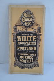
Maine Central RR Through the White Mtns-Portland to the St Lawrence River Book-1901JM Hobby Supply and Railroad Artifact Auctions4.4(127)See Sold PriceFeb 24, 2024
Union Pacific RR Across The Continent West From Omaha, NE Book-April 2, 1868JM Hobby Supply and Railroad Artifact Auctions4.4(127)See Sold PriceFeb 24, 2024
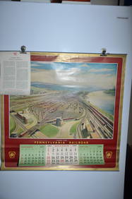
1958 Pennsylvania Railroad Calendar-Conway YardJM Hobby Supply and Railroad Artifact Auctions4.4(127)See Sold PriceFeb 24, 2024
Pablo Picasso (1881-1973) lithograph on Arches paper, titled "Les Satimbanques" (The Tumblers),Neely Auction4.6(224)See Sold PriceFeb 25, 2024
Christo Vladimirov Javacheff (1935-2020) and Jeanne-Claude Denat de Guillebon (1935-2009), known asNeely Auction4.6(224)See Sold PriceFeb 25, 2024
Autographed 1958 Topps Willie Mays and Duke SniderPast to Present Auctions4.3(7)See Sold PriceMar 02, 2024
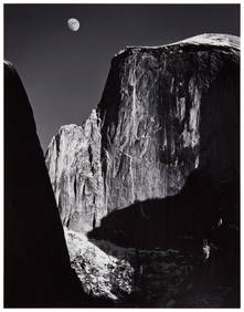
Ansel Adams (1902-1984), "Moon and Half Dome," Gelatin silver print on paper mounted to a boardJohn Moran Auctioneers, Inc.4.7(461)See Sold PriceFeb 27, 2024
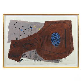
Ben Shahn 1898-1969 Lute and Molecule #1 PaintingHill Auction Gallery 4.7(1k)See Sold PriceFeb 28, 2024
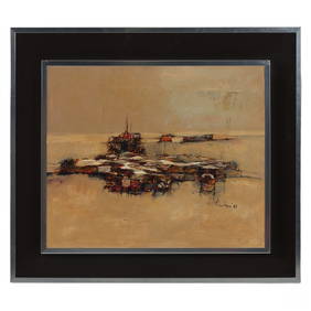
Nicola Simbari 1927-2012 Gypsy Encampment PaintingHill Auction Gallery 4.7(1k)See Sold PriceFeb 28, 2024
Antique German Kampen Town Color Copper EtchingHill Auction Gallery 4.7(1k)See Sold PriceFeb 28, 2024
Two (2) Antique 18th C. Copper Engraved Framed Maps - America & EuropeMagnusson Art Group4.5(53)See Sold PriceMar 14, 2024
Arrowsmith & Lewis - Map of the United StatesTrillium Antique Prints & Rare Books4.5(32)See Sold PriceFeb 24, 2024
Framed Space Age Rand McNally Map of Planets Poster, 1958PUBLIC SALE4.7(226)See Sold PriceMar 02, 2024
Brett James Smith (American/Louisiana, b. 1958), "Morning Mallard," 1984, H.- 20 in., W.- 30 in.,Crescent City Auction Gallery4.3(231)See Sold PriceMar 09, 2024
Randall Henry (American/Louisiana, b. 1958), "Interior Scene," 1981, H.- 24 1/4 in., W.- 30 1/2 in.,Crescent City Auction Gallery4.3(231)See Sold PriceMar 09, 2024